Masazir Lake is often introduced through photographs of pink water, but color is only one part of its story. Salt production, a changing shoreline and uncertain visitor access matter just as much when identifying the place or deciding whether to make a stop.
A salt lake, not a guaranteed pink-water stop
Masazir is a saline lake near Baku on Azerbaijan’s Absheron Peninsula, associated with salt production and sometimes pink-looking water. Research documents pigment-producing algae from the lake, but does not establish a guaranteed pink season. A currently permitted public shoreline viewpoint has not been confirmed, so do not assume unrestricted access.
Access information checked: November 18, 2026. No named, currently permitted public shoreline entrance or viewpoint was confirmed.
How to use this article: Understand the laboratory evidence, separate past reports from present conditions, or check what remains unresolved about access.
1. Where Masazir Lake lies near Baku
Masazir, also written Masazyr or Masazır, is an inland salt lake on the Absheron Peninsula near Baku. It is not the Caspian waterfront in the city center. The Azerbaijan country profile gives the wider geographic setting; the important local distinction is between the lake and the nearby settlement sharing its name.
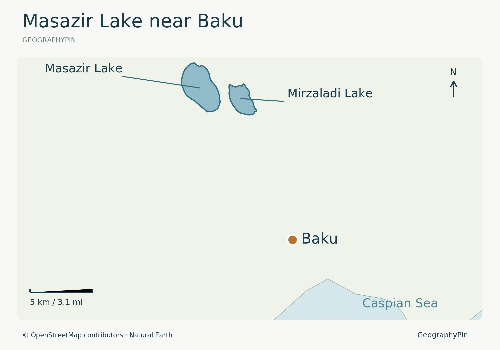
Use the lake’s name and location together when checking a photograph or map pin. “Pink Lake Baku” is a descriptive label, not enough by itself to identify a particular shore, an entrance or permission to stand there. A regional locator can show where the lake lies without claiming to provide a visitor route.
The lake occupies a depression between Novkhany and Masazir, a location documented in JICA’s 2001 environmental study of Baku. Mirzaladi is a separate lake to its east. That neighboring lake is a useful landmark when checking a map: do not treat the two names as alternatives for the same body of water.
The gray-looking water in the accompanying 2017 photograph records one moment, not a contradiction of the lake’s occasional pink appearance.
2. Why Masazir can look pink
The algae documented at Masazir
A 2017 laboratory study by Alizadeh and colleagues identifies its Dunaliella salina strain as originating from Masazir. The researchers cultured the microalga and examined carotenoid production under changes in salt concentration, ultraviolet exposure and temperature. Carotenoids are pigments; the results show that their production can respond to experimental conditions.
That is more specific than a generic claim that “algae make lakes pink,” but it remains a culture experiment. It does not measure how much each organism contributes to the visible color of the entire lake today, or establish which month will produce a particular photograph.
A separate 2022 microbiome study of Australia’s Lake Hillier found a community rich in pigment-producing microorganisms. That comparison helps explain why pink-lake biology should not automatically be reduced to one organism. It is evidence from Hillier, however, not a species census or color analysis of Masazir.
“Halophile” describes an organism adapted to salty conditions; it is not the name of one pink-producing bacterium. Masazir’s color belongs to a living saline environment rather than a fixed decorative feature.
3. Salt production is part of the landscape
The lake’s industrial setting is documented, not incidental. An official account dated July 21, 2010 records the opening of the Masazyr Salt Refinery beside the lake and a transport road linking the plant with the Masazyr–Novkhany highway. That road was described as salt-production infrastructure, not a public visitor entrance.
Azersun’s description of the Azerbaijan Salt Production Association identifies Masazir as its salt source and describes food and industrial salt production. This is the operator’s account of the business, not an independently audited statement of present output or a grant of tourist access.
The plant and its transport infrastructure make salt extraction part of the lake’s identity. This is a working landscape, not simply a natural backdrop for photographs, and industrial roads should not be mistaken for visitor facilities.
4. A shoreline shaped by development
What was documented in 2020 and 2023
In a September 19, 2020 inspection report, the Absheron district authority described wastewater infrastructure that did not fully intercept flows reaching Masazir’s salt lake. This establishes an officially documented problem at that time, not a current water-quality measurement.
Photographer Shahla Abbakirova’s June 29, 2023 Chai Khana photo essay documented salt work, trucks, fencing, shoreline waste and construction. Residents described losing access, while an interviewed environmentalist discussed altered water inflows and wastewater pressures. Those observations complicate the image of an untouched natural attraction.
Together, these dated accounts show a shoreline shaped by settlement, infrastructure and salt work. They do not provide a present-day contamination reading; the color of the water is not a water-quality test.
5. Can you visit Masazir Lake?
What would need confirming before a stop
The VisitSilkRoad listing includes a viewpoint facility label, but no named, currently authorized shoreline viewpoint was established by the access checks for this profile. A listing, a visible track and a photograph taken by someone else are not equivalent to permission.
If considering a stop, establish the exact permitted location and the authority responsible for access first. Do not cross fences or enter salt-working areas or industrial roads on the assumption that they are tourist facilities. Unconfirmed access also does not prove that every possible view of the lake is legally forbidden.
Keep the lake optional rather than making it the fixed centerpiece of a Baku day. The Baku travel guide offers city-based alternatives. No public swimming facility, supervised bathing access or medical use is established here; the lake’s appearance and salt-industry role do not supply that evidence.
What Did We Learn Today?
Masazir is best understood as a salt lake within an industrial and changing shoreline landscape. Laboratory pigment evidence, dated environmental reporting and permission to visit answer different questions. None makes a pink-water photograph or unrestricted shoreline stop certain, so location and context matter more than a promised color.
Sources & Data Notes
View lake, science and landscape sources
Sources and access information checked November 18, 2026. JICA’s 2001 report is used for local geography, not current environmental conditions. Historical inspections and photographs retain their dates. No current public shoreline permission was confirmed.
- Alizadeh and colleagues, 2017: cultured Dunaliella pigments
- Sierra and colleagues, 2022: Lake Hillier microbiome
- JICA, March 2001: Baku environmental study, lake locations (S2-3)
- Official presidency account: refinery opening, July 2010
- Azersun: Azerbaijan Salt Production Association
- Shahla Abbakirova, Chai Khana: June 2023 photo essay
- Absheron district authority: September 2020 inspection
- VisitSilkRoad: Masazir Lake listing
Photo: Masazir Lake, Qolcomaq, September 30, 2017; CC BY-SA 4.0. Resized by Wikimedia Commons; cropped for display.
Locator: GeographyPin, using © OpenStreetMap contributors, ODbL, retrieved November 18, 2026. Masazir polygon last edited September 24, 2025; Mirzaladi polygon June 20, 2024. These are map-edit dates, not water-level survey dates. Generalized coast and Baku reference point: Natural Earth Countries 5.1.1 and Populated Places 5.1.2, public domain. No visitor route or access point is depicted.