Lookout Mountain is easy to mistake for one summit above Chattanooga. From farther out, it is an elongated upland that continues across state lines. Understanding its shape means separating the sandstone-capped landscape from two neighboring municipalities, individual overlooks and the attractions that use the same name.
Lookout Mountain is a long upland in the southern Appalachians, extending southwest from Chattanooga through northwestern Georgia into northeastern Alabama. Its resistant sandstone cap, steep edges and dissected surface connect it to the Cumberland Plateau landscape. The mountain is not the same entity as the adjoining Tennessee town and Georgia city called Lookout Mountain.
How to use this article: Distinguish the regional district, interpret specific destinations, or compare rivers crossing uplands.
1. Locate the mountain across three states
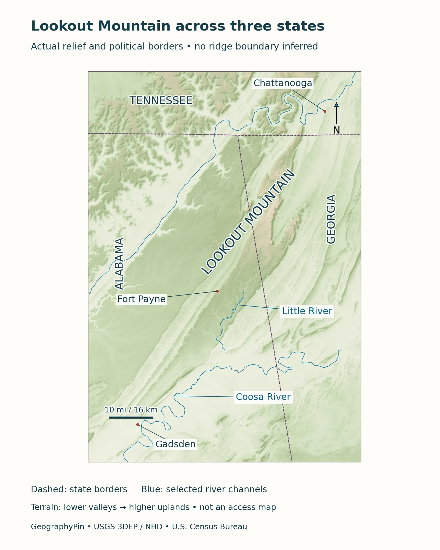
The familiar northern end rises beside Chattanooga, Tennessee. The upland continues through Georgia and into Alabama toward Gadsden. A map that stops at the Tennessee–Georgia line can locate the northern attractions but cannot explain the larger landform. Conversely, a regional map cannot resolve every street, property line or trail near the northern lookout.
A regional district is not a surveyed summit
The Geological Survey of Alabama describes the Lookout Mountain physiographic district as a narrow remnant of the Cumberland Plateau extending about 75 miles (121 kilometers) from Chattanooga to Gadsden, with a width of roughly 3–7 miles (5–11 kilometers). These are approximate dimensions of a district, not a measured hiking route or a boundary enclosing every place that uses the name.
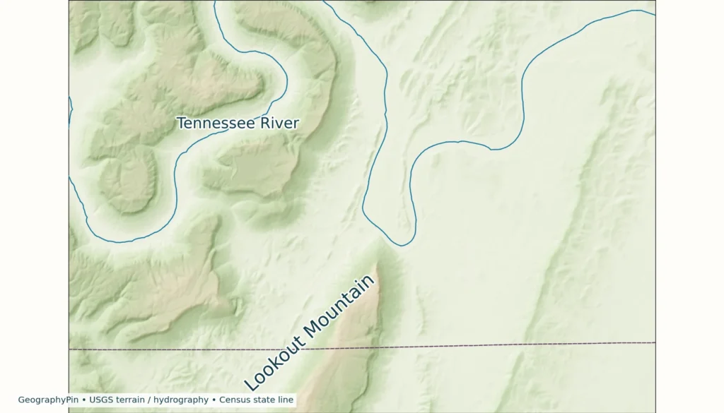
The long northeast–southwest orientation matters more for first-time map reading than choosing one point as “the mountain.” Relief imagery reveals the elongated high ground and neighboring valleys. State borders provide a separate political reference: they cross the landscape rather than defining its geological edges.
2. Separate the ridge, municipalities and visitor sites
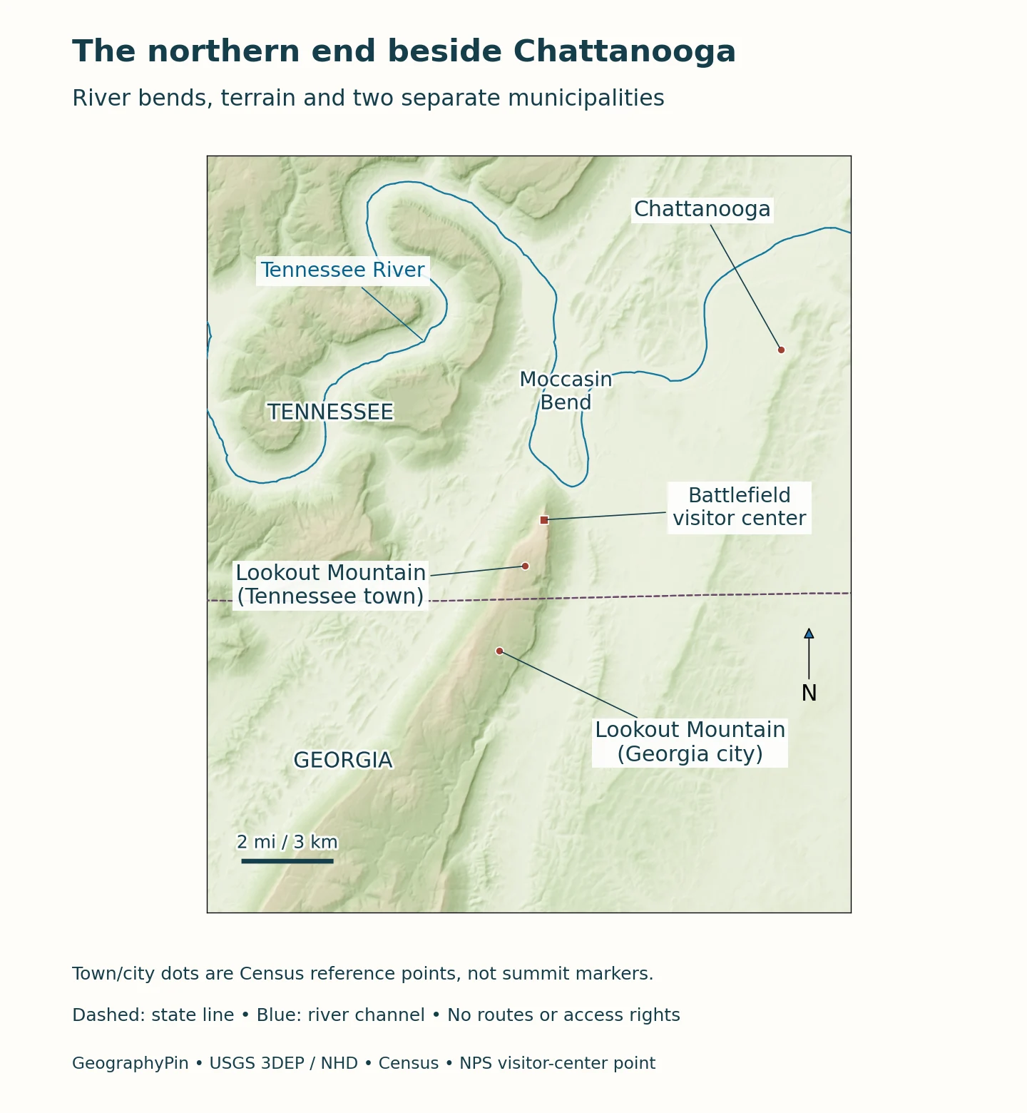
Lookout Mountain, Tennessee, and Lookout Mountain, Georgia, are neighboring municipalities near the northern end of the upland. The University of Tennessee’s municipal directory identifies the Tennessee community as a town in Hamilton County. The Georgia municipality maintains its own city government. Neither municipality represents the whole mountain across all three states.
| Name | Setting | What it identifies |
|---|---|---|
| Lookout Mountain upland | Tennessee, Georgia and Alabama | Physical landscape across state lines |
| Lookout Mountain, Tennessee | Hamilton County | Municipal town near the northern end |
| Lookout Mountain, Georgia | Georgia side of the state line | Separate municipal city |
| Point Park | Northern Lookout Mountain | National military park site, not the entire mountain |
The address is part of the answer
A request for directions to “Lookout Mountain” needs a more specific destination. An overlook, city office, trailhead and commercial attraction can share the mountain’s name without sharing an entrance or management. Use the actual site name and state when checking a map. A label placed at one tourist viewpoint should not be read as the geographic center or highest point of the entire upland.
The same distinction applies to conservation land. Point Park belongs to Chickamauga and Chattanooga National Military Park; Cloudland Canyon is a Georgia state park; Little River Canyon is a separate national preserve in Alabama. Their rules and boundaries do not combine into one continuous public park covering Lookout Mountain.
3. Read the plateau edge and the folded rocks beneath it
A broad, relatively level top can still be part of a folded landscape. National Park Service geological studies describe Lookout Mountain as an eroded, broad syncline that plunges gently southwest. A syncline is a downward fold in rock layers. It describes the structure beneath the land, not a requirement that the present surface must form a valley.
Resistant Pennsylvanian sandstone and conglomerate cap the northern mountain. Erosion removes weaker material more readily, helping leave resistant layers standing high above neighboring ground. This is why the shape is better understood as a dissected upland with steep margins than as an isolated cone. An escarpment is a steep slope or cliff marking such a change in level; it need not be one unbroken vertical wall.
The sedimentary layers record environments that existed before the present topography. Later folding during Appalachian mountain building and subsequent erosion produced a different arrangement of rocks and landforms. The age of a sandstone layer is therefore not the age of the modern cliff face. Nor does a flat-looking skyline mean that every point on the surface has the same elevation.
Little River Canyon exposes another part of this story farther southwest. The NPS describes resistant Pottsville sandstones and conglomerates above weaker sedimentary layers, with the canyon cutting into underlying Mississippian carbonate rocks. The landscape changes from gently rolling upland to steep cliffs and a narrow canyon floor. Those contrasts illustrate physical geography: geological structure and flowing water working together.
4. Follow the Tennessee River and the streams cutting the upland
At the northern end, the Tennessee River bends around the mountain’s nose beside Moccasin Bend. NPS geological interpretation describes deeply entrenched meanders in this part of the river’s course.
A river can cross an upland before cutting a canyon
Farther southwest, Little River flows for much of its course atop Lookout Mountain before descending through its canyon toward Weiss Lake. Its headwaters extend into northwestern Georgia, while the well-known canyon lies in northeastern Alabama. This is a useful counterexample to the assumption that rivers always occupy only the broad lowlands between mountains.
The Geological Survey of Alabama identifies Little River and Black Creek as major drainage features of the Lookout Mountain district. Little River ultimately joins the Coosa system at Weiss Reservoir. Thus, being on the same long upland does not mean that all local water flows north to the Tennessee River. A drainage map follows connected channels, not a shared mountain name.
Cloudland Canyon illustrates erosion on the western edge in Georgia. Its water-carved canyons expose the relief of the plateau margin. Compare the regional setting with the local gorge: a relatively broad upland can contain steep, deeply cut valleys that are difficult to appreciate from a small-scale road map.
5. Interpret heights, history and access at the right scale
Elevation above sea level, local relief and canyon depth answer different questions. A viewpoint’s elevation is not the vertical drop to the river below. Likewise, the highest point of a municipality is not automatically the summit elevation of the whole ridge. A terrain map shows variation across the surface, while a quoted measurement needs a named feature and reference.
| Measurement | Meaning | Limit |
|---|---|---|
| Elevation | Height relative to a vertical reference | A named viewpoint or summit, not the whole ridge |
| Local relief | Difference between nearby high and low ground | Not the same as elevation above sea level |
| Canyon depth | Difference between a rim and valley floor | Varies with the location measured |
| District length | Approximate regional extent | Not a trail length or legal boundary |
The commanding northern slopes also help explain the mountain’s historical importance. During the Chattanooga campaign, positions on Lookout Mountain overlooked routes and Union forces below. The Battle of Lookout Mountain took place on November 24, 1863. Today Point Park interprets part of that history, while Moccasin Bend remains visible across the Tennessee River. A battlefield viewpoint is one geographically significant place, not a substitute for the whole regional landscape.
Before visiting, check current information from the national military park, Cloudland Canyon or Little River Canyon. A national-park area, state park and privately operated attraction can have different entry arrangements. Do not infer public access from a ridge label or assume that a scenic map depicts a continuous marked route. Cliffs, canyon edges and caves require particular care; the explanatory maps here are not navigation or access-permission maps.
What Did We Learn Today?
Lookout Mountain is a long, sandstone-capped upland spanning Tennessee, Georgia and Alabama, not just a single Chattanooga viewpoint. Its folded rocks, resistant cap and river-cut valleys explain the plateau-like surface and steep edges. Town names, state borders, park units and individual attractions describe different things, while elevations and distances only make sense when their measured feature is clear.
Sources & Data Notes
The regional length and width follow the Geological Survey of Alabama’s physiographic district description. They are approximate, not a surveyed ridge boundary. Feet and miles are paired with rounded metric conversions. Maps do not establish access rights.
The maps combine USGS 3DEP elevation rasters and named National Hydrography Dataset river geometry with U.S. Census Bureau state borders and municipal reference points. Relief shading represents actual terrain, not a geological or property boundary. The visitor-center point follows NPS coordinates; municipal dots are not summit locations. Selected river lines are not a complete drainage network. The featured image is an original terrain-map detail, not a photograph.
- Geological Survey of Alabama Bulletin 186, physiographic districts
- NPS 2009 Chickamauga and Chattanooga geological scoping summary
- NPS Little River Canyon geodiversity
- NPS Little River Canyon description
- NPS Lookout Mountain and Point Park
- Georgia State Parks: Cloudland Canyon
- University of Tennessee municipal directory: Lookout Mountain
- City of Lookout Mountain, Georgia
- NPS Chickamauga and Chattanooga geodiversity atlas
- USGS 3DEP elevation data
- USGS National Hydrography Dataset river geometry
- U.S. Census Bureau cartographic boundaries
- Census TIGERweb municipal reference points
- NPS battlefield visitor-center coordinates