A mountain slope can send air uphill while it is in the sun and let colder air drain downhill once it falls into shadow. At La Fouly in the Swiss Alps, researchers measured what happened between those two states. The reversal did not arrive all at once: for a short time the breeze was weak and kept shifting direction.
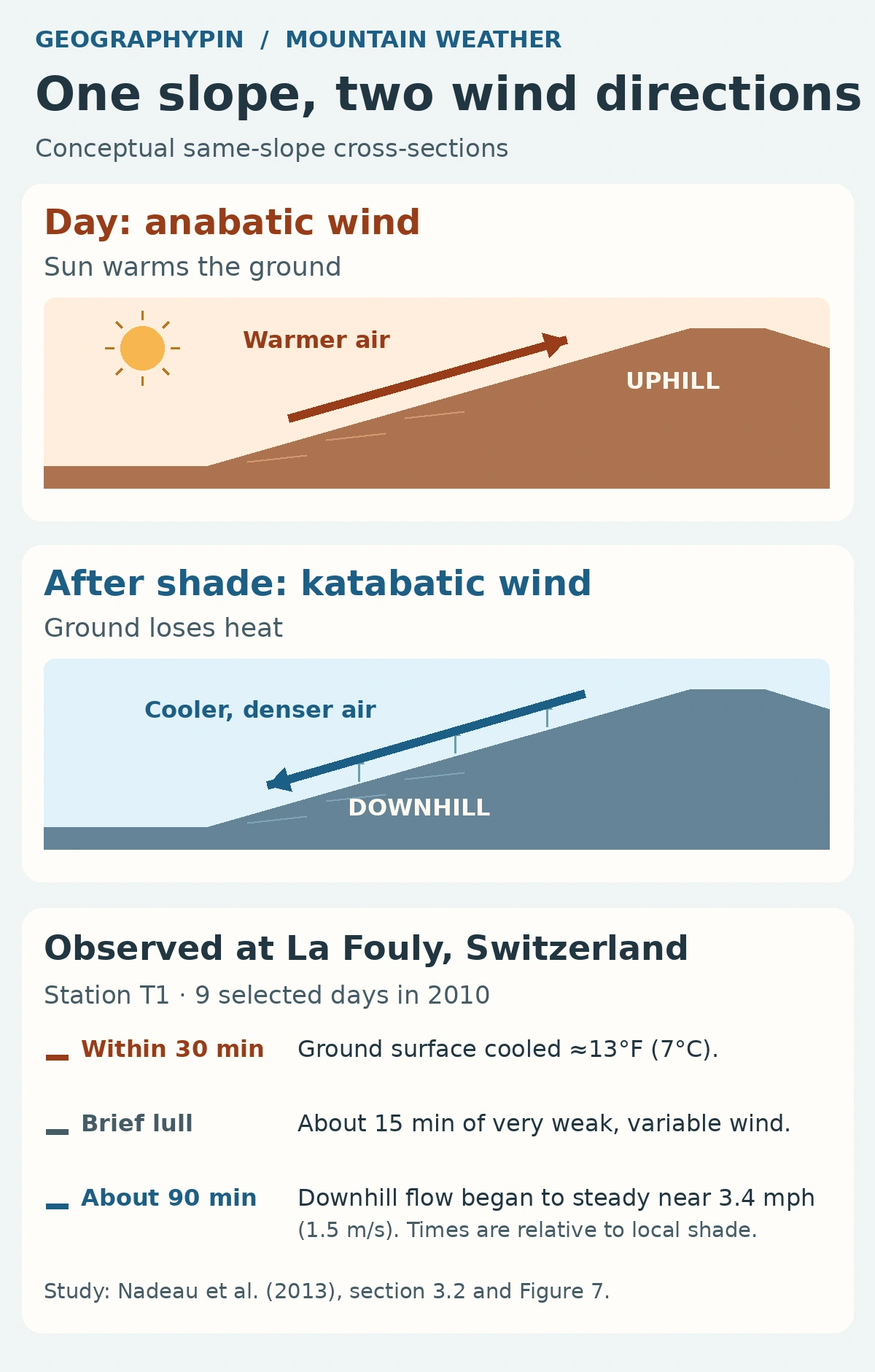
An anabatic wind moves uphill as a sun-warmed slope heats the air next to it. A katabatic wind moves downhill when air near a cold slope becomes denser than the surrounding air and drains under gravity. These winds can be shallow, so a breeze along a hillside can blow in a different direction from the wind above it or along the valley floor.
How to use this article: Follow the arrows on one slope, see what changed when shade reached La Fouly, or learn what to compare in the field.
Why warmed air moves uphill
Start with the ground, not the clock
Sunlight warms the ground. The ground then warms the air touching it, making that air less dense than cooler air at the same height away from the slope. On a hillside the resulting buoyant flow follows the slope upward. The National Weather Service glossary calls this local heating-driven flow an anabatic wind.
Look for it when the slope has had time to warm but still receives direct sunlight. The window differs between slopes: a ridge can put one hillside in shadow while the facing hillside is still lit. A strong background wind or persistent cloud can make the local pattern much less distinct.
What changes when the slope cools
When a ridge cuts off direct sunlight, the ground can lose more heat than it gains. As the surface cools, it cools the air next to it. If that air becomes denser than the surrounding air at the same height, gravity can send it downslope. This is katabatic drainage. The cold layer is often shallow; air a little higher up does not have to turn with it.
The key is the change in the surface’s heat balance, not the moment sunset appears on a phone. Shade can reach a valley side before the Sun sets at an unobstructed horizon. Even once heating stops, the previous flow can weaken first and the new flow can take time to form.
What observers measured at La Fouly
The wind paused before it drained downhill
In 2010, researchers worked on a steep west-facing slope near La Fouly, Switzerland. Their field study summarized nine clear days with weak regional pressure gradients. They lined up the records at station T1 by the time the slope entered local shade, which was not the same clock time on every date.
- Within 30 minutes: The ground surface cooled by about 13°F (7°C). The air at 8 feet (2.5 meters) cooled more slowly.
- Between wind directions: Near-surface up-valley wind stopped a few minutes after shade. Before the downhill flow developed, there was a roughly 15-minute spell of very weak wind from varying directions.
- About 90 minutes after shade: Downslope wind speed began to steady near 3.4 mph (1.5 m/s).
The distinction matters: the earlier wind at T1 was up the valley, not necessarily up the slope. A separate tethered-balloon profile before local shade on August 21 recorded uphill flow close to the surface. It shows that an upslope wind did occur at the site, but it is not the opening segment of the nine-day station summary. Neither result gives a countdown you can apply to another hillside.
How to tell a slope wind from a valley wind
Compare two directions, then look for a temperature change
First identify the steepest uphill direction at your observation point. On a valley wall that direction can be nearly across the valley, while the river and the valley floor run lengthwise. A wind blowing upstream along the river is an up-valley wind; it is not an upslope wind unless it actually climbs the hillside there.
Next ask whether the change tracks local heating or cooling. A hillside breeze that weakens when shade arrives and later runs downhill fits the thermal explanation better than a downhill arrow on its own. Compare it with a reading on the valley floor or at an exposed site higher up. If the directions disagree, that can be a shallow slope flow beneath a different valley or regional wind. A strong wind that changes at the same time over a broad area gives you a reason to check the larger weather pattern instead.
Frequently Asked Questions
Can a katabatic wind blow downhill in daylight?
Yes. When a snowfield or glacier is colder than the air above it, it can cool the air touching it even in daylight. The cold air can then drain down the ice or slope. Night is a common setting for drainage over land, not part of the definition.
Is a warm föhn wind also katabatic?
Not in the cold-drainage sense used here. A föhn is a lee-side wind associated with flow across a mountain barrier; descending air can warm as it is compressed. A katabatic wind starts because cold, denser air can drain downhill. Direction alone does not tell you which process is at work.
Can the valley floor end up colder than the hillside?
Yes. In sheltered terrain, cold air can collect in low areas instead of continuing out of the valley. That can leave colder air below warmer air, a temperature inversion. A valley with stronger mixing or an unobstructed outlet need not hold onto that cold pool.
What Did We Learn Today?
Sunlit ground can drive air uphill. A cooling slope can send denser air back downhill, but there may be a lull between the two, and winds higher up or along the valley can keep blowing in another direction. At La Fouly the timing followed shade at the ground. Compare direction, temperature and exposure before assigning a name to the wind.
Sources & Data Notes
Open the field study, definitions and photo credit
The original diagrams are conceptual. The observed estimates summarize the T1 record aligned to local shade on nine selected summer 2010 days (sections 2 and 3.2, Figure 7). The August 21 tethered balloon measurement is separate (section 3.3, Figure 8); the paper reports it at 17:47 CET. The surface-temperature difference is rounded after conversion to Fahrenheit.
- Nadeau and colleagues (2013), Flow during the evening transition over steep Alpine slopes, DOI 10.1002/qj.1985.
- National Weather Service weather glossary, slope flow and winds along the valley axis.
- National Weather Service, flight environment, cold air drainage over ice and snow.
- MeteoSwiss, foehn mechanisms and National Weather Service, temperature inversions.
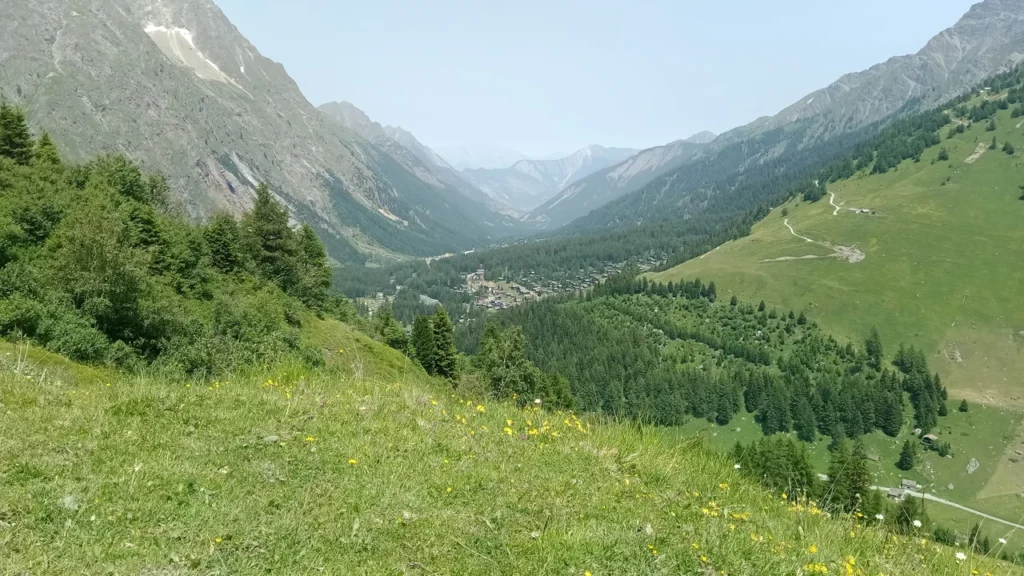
La Fouly photograph: La Fouly @ Léchère Dessus, Rémih, June 28, 2023, CC BY-SA 4.0. Cropped, resized and converted to WebP under the same license. The photo places La Fouly in Val Ferret; it does not identify the study instruments or document wind direction.