
Jamaica’s coastline is familiar, but its interior explains much of the island’s geography. Eastern mountains, limestone uplands and coastal plains influence where water flows, where people settle and how communities connect. Looking beyond the beach reveals a country shaped as much by steep slopes and underground drainage as by the Caribbean Sea.
Jamaica is predominantly mountainous and hilly, not a broad coastal plain. The Blue Mountains rise in the east, while limestone uplands and the deeply dissected karst of Cockpit Country shape much of the interior. Coastal plains are narrower and discontinuous, although their ports, towns and transport corridors give them importance far beyond their share of the land.
How to use this article: Explore the Blue Mountains, understand Cockpit Country’s karst, or distinguish Kingston from parish statistics.
1. Where Is Jamaica?
Jamaica is an independent island country in the Caribbean Sea, south of Cuba and west of Hispaniola. It belongs to the Greater Antilles, the group of large islands in the northern Caribbean. Its neighbors are separated by sea rather than land borders.
The main island is elongated from west to east. Kingston, the capital, lies on its southeastern coast, while Montego Bay is on the northwestern coast. This orientation matters: the north coast is not the same urban corridor as the capital’s harbor-facing southeastern setting.
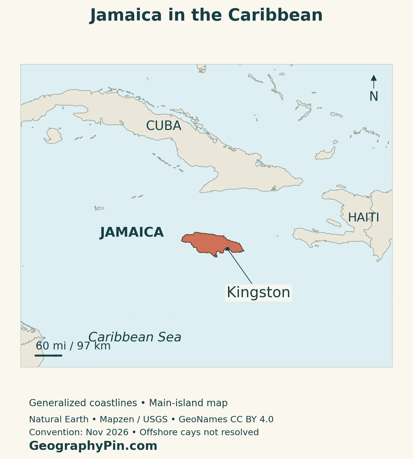
The country also includes smaller offshore islands and cays. A regional-scale map necessarily simplifies these small features; the familiar outline of the main island is not a detailed inventory of every offshore component or maritime limit.
Our Caribbean countries and territories map places Jamaica among the region’s independent states and distinguishes those countries from dependent territories. Jamaica’s position within the Caribbean does not make it part of a neighboring country.
2. Country Facts with Dates and Scope
| Fact | Detail |
|---|---|
| Capital | Kingston |
| Population | 2,774,538 in the 2022 Population and Housing Census; a census-year figure, not a 2026 estimate |
| Surface area | About 4,243 square miles (10,990 km²); UNData reference year 2023, not land-only |
| Highest point | Blue Mountain Peak, about 7,402 feet (2,256 meters) |
| Language | English is the official language; Jamaican Creole is widely used in everyday life |
| Currency | Jamaican dollar (JMD) |
| Government | Parliamentary constitutional monarchy; proposed republican reforms should not be confused with an implemented change |
| Administrative geography | 2022 census geography: 14 parishes; later legislation provides for Portmore as a 15th parish, with boundary implementation addressed separately |
The population figure refers to the 2022 census, even though the results were released later. A release date and a population reference date answer different questions. UNData separately lists a 2025 medium-variant projection of about 2.837 million; that modeled series is not another count taken in the 2022 census.
Area also needs a definition. The surface-area figure includes inland water rather than describing only dry land. It does not measure the much larger marine space associated with Jamaica’s maritime jurisdiction.
3. Mountains, Limestone Uplands and Coastal Plains
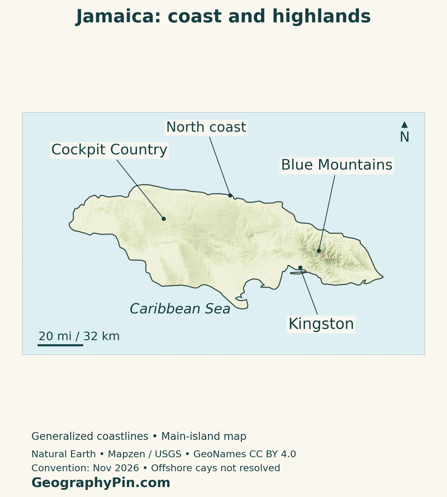
Jamaica’s relief is varied rather than a single uniform mountain chain. The eastern Blue Mountains contain its highest ground. Farther west, limestone uplands form a different kind of rugged interior, with hills, enclosed depressions and caves. Lower coastal ground interrupts this upland pattern but does not replace it.
| Setting | Physical character | Why it matters |
|---|---|---|
| Blue Mountains and eastern uplands | High ridges, steep slopes and forested catchments | Altitude, rainfall and headwaters differ from nearby lowlands |
| Cockpit Country | Limestone hills separated by steep-sided closed depressions | Karst links the visible terrain to underground drainage |
| Other limestone and interior uplands | Hills, plateaus and locally deeper soils | Aquifers, farming and mineral deposits vary with the underlying geology |
| Coastal plains and harbor corridors | Lower ground around parts of the island’s edge | Ports, settlements and connections concentrate in accessible coastal settings |
The Blue Mountains Are More Than a High Point
Blue Mountain Peak rises to approximately 7,402 feet (2,256 meters). The surrounding uplands create substantial height differences over a relatively small island. Moving inland from the southeastern coast therefore means more than increasing distance from the sea: it also means entering a cooler, steeper environment.
The Blue and John Crow Mountains World Heritage property recognizes both natural and cultural significance. Its forests and varied elevations support distinctive habitats, while its rugged landscape provided refuge for Taíno people and later Maroon communities. Trails, settlements and places of resistance connect human history with the terrain.
The protected property is not identical to every place called the Blue Mountains. A regional mountain label describes a broad landform, whereas a conservation boundary identifies a particular legally or internationally recognized area.
Why Cockpit Country Has Enclosed Depressions
Cockpit Country is a limestone karst landscape. Water dissolves the rock along fractures and other pathways, helping create steep-sided depressions surrounded by hills. Many depressions drain underground rather than through an obvious surface outlet. The repeated pattern of hills and hollows gives the region its distinctive appearance.
The landscape also has a cultural history, including its importance to Leeward Maroon communities. Its difficult terrain supported refuge and resistance, so the hills cannot be understood solely as geological shapes.
Cockpit Country Protected Area was submitted to UNESCO’s Tentative List in April 2025. That is different from World Heritage inscription: it is a proposed site under consideration, unlike the already-inscribed Blue and John Crow Mountains.
4. Water beneath and across the Island
Jamaica’s uplands divide drainage toward different coasts. Streams descend from the interior, but the visible river network is only one part of the freshwater system. In limestone country, water can enter the rock and travel below the surface.
Karst Makes Groundwater Especially Important
The Water Resources Authority distinguishes limestone aquifers from alluvial aquifers made of river-deposited gravel, sand, silt and clay. In the White Limestone Group, fractures and karst conduits allow substantial infiltration and underground movement. The aquifer can be compartmentalized rather than behaving as one evenly connected underground reservoir.
Coastal reef limestone has its own characteristics: it can transmit water readily while providing limited storage. Permeability and storage are different properties. A rock that lets water move quickly is not necessarily a large, dependable reserve.
These differences explain why a surface map alone cannot show every freshwater connection. A dry depression in limestone terrain does not automatically mean there is no drainage, and neighboring places can have different groundwater conditions even when both look green on a landscape photograph.
5. Rainfall, Elevation and Seasonal Contrasts
Jamaica has a tropical maritime climate, modified by elevation and exposure. Coastal lowlands are generally warmer than the higher interior. Northeast trade winds are an important influence, while the mountains create local contrasts that a single national temperature or rainfall average cannot capture.
The Office of Disaster Preparedness and Emergency Management describes rainfall peaks around May and October, with relatively drier conditions commonly occurring in January, February, March and July. This is not simply one uninterrupted wet season followed by one uninterrupted dry season.
Those averages do not guarantee conditions in a particular month. Rainfall varies between years and places. Drought can also develop differently in soils, rivers and stored water: crop moisture stress and low reservoir levels need not begin or end at exactly the same time.
For an island with steep terrain and concentrated coastal settlement, the location of rainfall matters as much as the national total. The same map that identifies uplands and coastal plains helps explain why water management must consider catchments, slopes and the communities downstream, rather than treating the island as one uniform surface.
6. Kingston, the North Coast and Parish Geography
Kingston’s southeastern harbor setting contrasts with the north coast’s string of towns and visitor destinations. Montego Bay, Ocho Rios and Port Antonio occupy different parts of that northern coastline; they are not suburbs of the capital. The island’s elongated shape makes these regional distinctions easy to see on a map.
Kingston Is Not the Same Statistical Area as Kingston and St. Andrew
Place names and statistical boundaries need care. In the published 2022 census comparison, Kingston and St. Andrew are presented together, with 672,904 people. That combined figure should not be labeled the population of Kingston parish alone or assumed to describe a precisely bounded urban footprint.
St. Catherine, listed separately, had 542,763 people in the same census table. Comparing parish figures helps show the scale of settlement around the southeastern part of the island, but it does not by itself define a metropolitan boundary.
The 14-parish framework used for the 2022 census consists of administrative and historical units, not physical regions. A mountain range, aquifer or karst landscape can cross parish boundaries. Cockpit Country, for example, extends across parts of several parishes rather than matching a single administrative outline.
Parliament passed legislation in February 2025 to establish Portmore as a 15th parish. In June 2026, the Electoral Commission was still consulting on electoral-boundary realignment to meet constitutional requirements. Those later changes must not be read back into the 2022 figures: the St. Catherine total above uses the census-era geography, not a newly separated Portmore area.
Language adds another layer to everyday geography. English is used officially, while Jamaican Creole has a central place in daily communication and cultural expression. University of the West Indies research describes speakers moving between Jamaican English and Jamaican Creole according to context. Listing English in a facts table should not suggest that everyone speaks in the same way in every setting.
7. Government and Economic Connections
Jamaica’s constitutional system remains distinct from proposals to reform it. The official republic-bill tracker, checked November 16, 2026, describes legislation intended to replace the monarch with a non-monarchical head of state; it does not show completion of assent and gazetting. A proposal to become a republic should therefore not be presented as an already implemented constitutional change.
The country’s economic geography also reflects its contrasting landscapes. The Jamaica Bauxite Institute describes bauxite deposits as red-earth pockets and blankets associated with the interior’s white limestone. The relationship is geological, not simply a coincidence between mining and upland scenery.
Coastal connections serve different functions. Port Authority statistics distinguish domestic cargo from transshipment cargo at Kingston, as well as recording cruise activity at ports including Montego Bay, Falmouth and Ocho Rios. Cargo transferred between ships is not the same as goods imported for Jamaican consumption, and a cruise call is not the same activity as a container-terminal operation.
Together, these connections link interior resources, coastal towns and international routes. A country map becomes more informative when it distinguishes the harbor-based capital, the northern visitor corridor and the limestone interior, instead of treating all coastal places as equivalent.
For the wider regional reference, see our North American countries and capitals. Jamaica’s Caribbean setting is part of that broader continental geography, while its particular combination of mountains, karst and settlement gives it a distinct national profile.
What Did We Learn Today?
Jamaica is an upland island whose coastal places have an importance greater than their physical extent. The eastern mountains and western limestone landscapes differ in form, history and water movement. Kingston’s harbor setting, the north coast and interior resource areas connect these landscapes to settlement and economic activity. Reading parish statistics, conservation designations and dated population figures carefully keeps those distinct geographic layers clear.
Sources & Data Notes
Population and parish comparisons refer to the 2022 census, not the date of their later publication. The separate UN projection is identified by its own year and method. Surface area follows UNData’s 2023 reference series. Older geography pages are used for stable terrain and place relationships, not historical population, production or land-use statistics. Constitutional reform status was checked November 16, 2026.
- STATIN: 2022 census population change by parish
- UNData: surface area, currency and separate population projection
- Jamaica National Heritage Trust: stable physical geography and Blue Mountain Peak
- Electoral Commission of Jamaica, June 2026: Portmore legislation and boundary realignment
- Embassy of Jamaica: landforms, coastal towns and climate setting
- UNESCO: Blue and John Crow Mountains World Heritage property
- UNESCO Tentative List: Cockpit Country Protected Area, submitted April 2025
- Water Resources Authority: Jamaican aquifer types and characteristics
- ODPEM: rainfall seasonality and drought processes
- University of the West Indies: English, Jamaican Creole and code-switching
- Ministry of Justice and Constitutional Affairs: republic-bill tracker
- Jamaica Bauxite Institute: bauxite and limestone geology
- Port Authority of Jamaica: January 2025 shipping publication, cargo and cruise categories
Map method: Original GeographyPin cartography uses public-domain Natural Earth country, coastline, lake and Kingston-point geometry. These main-island maps do not resolve offshore cays or maritime limits. Blue Mountains and Cockpit Country reference coordinates come from GeoNames under CC BY 4.0; they were reprojected and rendered as labeled points, not protected-area outlines or complete regional extents. The north-coast pointer is anchored to the source shoreline. Relief uses Mapzen Terrain Tiles with USGS SRTM/GMTED2010 elevation; the source elevation mosaic required no inland-cell repairs. Elevation colors represent height, not vegetation. The featured flag-filled outline is decorative cartography, not a maritime jurisdiction map.

