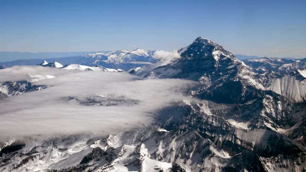
Aconcagua in Argentina is South America’s highest mountain. Argentina’s national mapping agency measured its summit at 22,837 feet (6,960.8 m) above mean sea level. Ojos del Salado, on the Chile–Argentina border, is lower than Aconcagua but has a separate distinction: it is the highest volcano above sea level.
Aconcagua leads, followed by Ojos del Salado and Monte Pissis. The order is less secure farther down the table. Some published measurements put Peru’s Huascarán Sur above Bonete Chico; others place it below.
How to use this comparison: Find the peaks in the map and table, then see which summits count separately and why close elevations are not definitive ranks.
The highest Andean summits compared
Eight summit locations and published heights
These eight long-recognized high summits are sorted by the particular source values shown. The list uses an independent-summit rule to avoid counting every high point on the same mountain, and relies on published agency elevations rather than reading the top of a cell in a digital terrain model. These measurements were not all made in the same year or reduced to one common vertical datum.
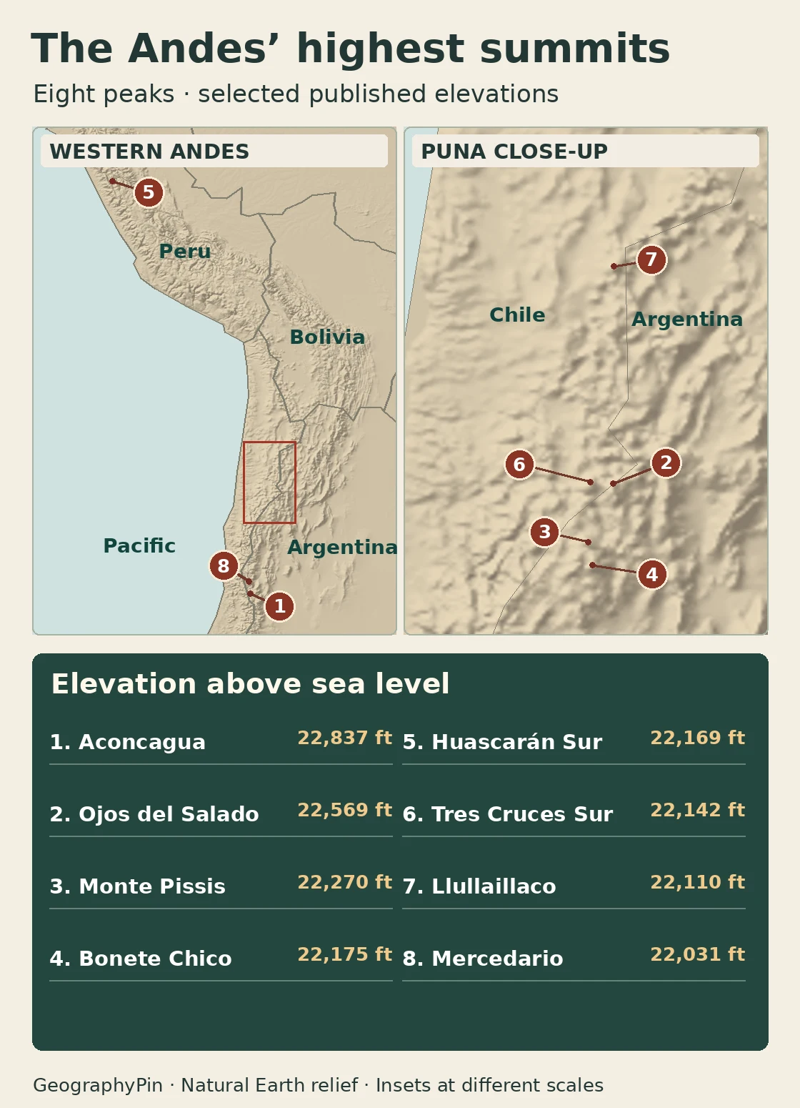
| Order here | Summit | Location | Feet | Meters |
|---|---|---|---|---|
| 1 | Aconcagua | Argentina | 22,837 | 6,960.8 |
| 2 | Ojos del Salado | Argentina–Chile | 22,569 | 6,879 |
| 3 | Monte Pissis | Argentina | 22,270 | 6,788 |
| 4 | Bonete Chico | Argentina | 22,175 | 6,759 |
| 5 | Huascarán Sur | Peru | 22,169 | 6,757 |
| 6 | Tres Cruces Sur | Argentina–Chile | 22,142 | 6,749 |
| 7 | Llullaillaco | Argentina–Chile | 22,110 | 6,739 |
| 8 | Mercedario | Argentina | 22,031 | 6,715 |
The spreadsheet identifies the base source for every row. Aconcagua’s decimal is the precision actually published by the Argentine survey; other elevations are reported in whole meters. Feet are converted and rounded. No nominal entries tie, but the source differences discussed below matter more than the apparent precision of a small gap.
A border summit is still one mountain
Aconcagua’s summit is in Mendoza, Argentina, not on the line with Chile. Ojos del Salado and Llullaillaco are border summits. A count by country may show a shared mountain under both countries, but a continental summit table counts it once. The map uses one marker per summit. It is not intended to resolve exact boundary placement on a ridge.
Geography matters even between nearby peaks. In the high, dry Andes of the Chile–Argentina frontier, Ojos del Salado and Tres Cruces are separate mountains despite their proximity. Farther north, Huascarán Sur is in Peru’s Cordillera Blanca. Ecuador’s high capital is a different question altogether: Quito’s elevation describes where a city sits, not the height of a surveyed Andean summit.
What makes a summit independent?
The 400-meter cutoff
Elevation asks how high a point sits above sea level. Topographic prominence asks how far you must descend from a summit before reaching higher ground. Find the highest saddle connecting the peak to any higher summit, then subtract that saddle’s elevation from the peak’s elevation. A hypothetical 6,700-meter point linked by a 6,450-meter saddle has 250 meters of prominence even though its elevation is 6,700 meters.
This comparison uses a 400-meter (about 1,312-foot) screening rule, following the regional summit compiler’s inclusion method. The cutoff identifies reasonably independent high mountains; it is not a universal definition. For example, if several high shoulders belong to the same massif and their saddles fail the rule, they do not get independent entries. The eight cases are the top eight entries in the regional compilation before updating their heights from agency sources. Its wider list also includes Huascarán Norte and Tres Cruces Central as independent summits under its cutoff; they sit below the eight compared here.
Why official summit heights can disagree
Comparing agency height estimates
Argentina’s Instituto Geográfico Nacional (IGN) established Aconcagua’s 6,960.8-meter height using GPS and gravity measurements during 2011 and 2012. Its summary table rounds the figure to 6,961 meters. That is not a competing measurement. Older published figures such as 6,959 meters are different values, not a whole-meter rounding of 6,960.8.
For Ojos del Salado, Argentina’s IGN and the Smithsonian’s Global Volcanism Program use 6,879 meters. A Chilean geological report gives 6,893 meters. Neither figure threatens Aconcagua’s lead: with the first, the difference is 81.8 meters; with the second it is 67.8 meters. Those are differences between selected published numbers, not new geodetic measurements.
Other published heights have also moved the order. Argentina’s 2015 statistical yearbook printed 6,882 meters for Pissis, above its then-listed Ojos figure of 6,879. The Argentine IGN’s current list puts Pissis at 6,788. That is a difference between source editions, not proof of a physical change. The Andes compilation puts Llullaillaco at 6,752 meters, above Tres Cruces Sur in that list, while the Argentine IGN and Smithsonian use 6,739 for Llullaillaco.
Small gaps can reverse. Peru’s INAIGEM expedition reported 6,757 meters for Huascarán Sur in 2017, putting it 2 meters below the current Argentine IGN figure of 6,759 for Bonete Chico. Peru’s digital IGN atlas instead gives Huascarán 6,746 meters, while the national tourism inventory gives 6,768. Using 6,746 would put it below the 6,749-meter Tres Cruces entry; using 6,768 would put it above Bonete Chico. The alternative values illustrate sensitivity to source and measurement convention. They do not establish which peak changed height or by how much.
Frequently Asked Questions
Does the highest volcano also have the highest summit?
No. The Smithsonian identifies Ojos del Salado as the world’s highest volcano above sea level. Aconcagua is the higher mountain. Above sea level is the comparison here; height above the mountain’s own base is a separate question.
Can I subtract these elevations to work out a climb’s elevation gain?
No. A route’s gain depends on its starting elevation and any descent and reascent along the way. Summit elevation alone tells you neither the route’s gain nor its difficulty.
Can rounding create a tie?
Yes. For instance, 6,757 and 6,759 both round to 6,760 meters if rounded to the nearest ten. More importantly, values from different surveys can differ by more than the nominal gap, so the order may be uncertain even when the table shows distinct numbers.
What Did We Learn Today?
Aconcagua is South America’s highest summit and Ojos del Salado holds the volcano record. To read the rest of the ranking, check which points qualify as independent mountains and which agency elevations the table used. The boundaries between countries and the gaps between published heights are different questions.
Sources & Data Notes
Show sources and summit notes
- Argentina IGN: Aconcagua summit announcement and Argentina IGN: maximum heights and depressions. The summary table provides elevations and mapped feature coordinates for the Argentine and border entries. These are not route or legal boundary coordinates. Argentina’s 2015 statistical yearbook: historical Pissis discrepancy.
- John Biggar’s original Andes summit compilation: independent summit screening, 400-meter prominence, named summits and alternative elevations. The table shown here substitutes agency elevation records where stated and does not inherit Biggar’s original height rankings.
- Smithsonian Global Volcanism Program: highest volcanoes and Chile SERNAGEOMIN report: Ojos del Salado comparator.
- Peru INAIGEM GNSS survey, Peru IGN digital atlas, and Peru MINCETUR inventory: distinct published heights for Huascarán. Map location checked against INAIGEM digital geographic record.
- Natural Earth shaded relief (public domain) was used only to shade the locator. Featured photo: Aconcagua fjell, Roberto Castillo, public-domain release, photographed December 29, 2007; cropped and compressed.