Haleakalā’s summit can look like a separate world from Maui’s wet coastal valleys. Reading the park as a mountain landscape, rather than one sunrise viewpoint, reveals how erosion, renewed eruptions and elevation connect its very different settings.
Haleakalā National Park lies on Maui, Hawaiʻi, extending from a 10,023-foot (3,055-meter) summit to the southeastern coast at Kīpahulu. Its two visitor districts have separate road approaches. The great summit depression was shaped mainly by erosion, while later eruptions added the lava flows and cinder cones within it.
How to use this article: Locate the summit within the park, follow how the depression formed, or check why coastal water access needs care.
1. Where Is Haleakalā National Park?
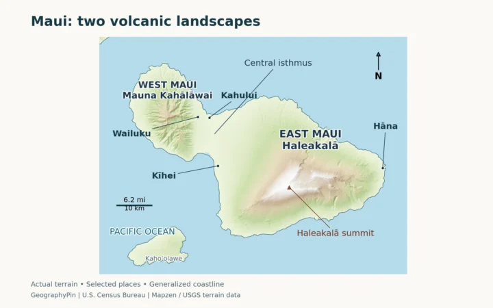
Haleakalā National Park occupies part of East Maui in Hawaiʻi. It reaches from the high summit of Haleakalā down the mountain’s southeastern flank to the coast at Kīpahulu, near Hāna. The protected landscape belongs to one island, but its upper and coastal visitor areas have very different settings and approaches.

Haleakalā is also the name commonly used for East Maui volcano. The volcano is much larger than the national park: a geological feature and a protected-area boundary are not interchangeable. Likewise, “Haleakalā Crater” names the great summit depression, not the entire mountain.
The summit is not the whole park
Puʻuʻulaʻula is the highest point in the park and on Maui, at 10,023 feet (3,055 meters). The summit observation area looks across the depression rather than standing on its floor. A photograph taken from the rim can therefore conceal how far the landscape drops away below it.
The neighboring observatories are another important distinction. They are on an adjacent hill, outside the national park, and the National Park Service says they are not open to the public. Visible buildings on the skyline are not automatically park visitor facilities.
2. Summit and Kīpahulu: Two Different Visitor Areas
The park’s Summit District and Kīpahulu District should not be treated as consecutive stops on one road through the mountain. NPS identifies separate approaches, with no direct road connection between the two. A short distance on a map is not the same as a short drive across steep volcanic terrain.
| District | Geographic setting | What to distinguish |
|---|---|---|
| Summit | High volcanic landscape, summit overlooks, cinder cones and shrubland | The broad erosional depression is different from the smaller volcanic cones within it. |
| Kīpahulu | Southeastern coast, streams, waterfalls and wet vegetation | Public coastal trails are different from the restricted biological reserve farther up the valley. |
Kīpahulu is more than a waterfall stop
Kīpahulu’s visitor area lies beyond Hāna along the coastal highway. ʻOheʻo Gulch and the Pīpīwai Trail belong to this side of the park, not to the summit approach. Water draining down the mountain helps organize a landscape of stream channels, falls and coastal outlets.
Higher in Kīpahulu Valley, wet forest and bog habitats are protected within a biological reserve. NPS limits entry there to authorized researchers and resource managers. That is not an invitation to continue uphill beyond public trails. The absence of visitor development is part of the reserve’s protection, not a missing section of a tourist route.
3. Why the “Crater” Is an Erosion-Shaped Valley
The familiar name “Haleakalā Crater” can suggest that one eruption blasted out the enormous summit hollow. The USGS describes a different history: two valleys expanded into the summit area and joined, producing a large erosional depression. It was not simply a volcanic crater or a caldera created by collapse above an emptied magma reservoir.
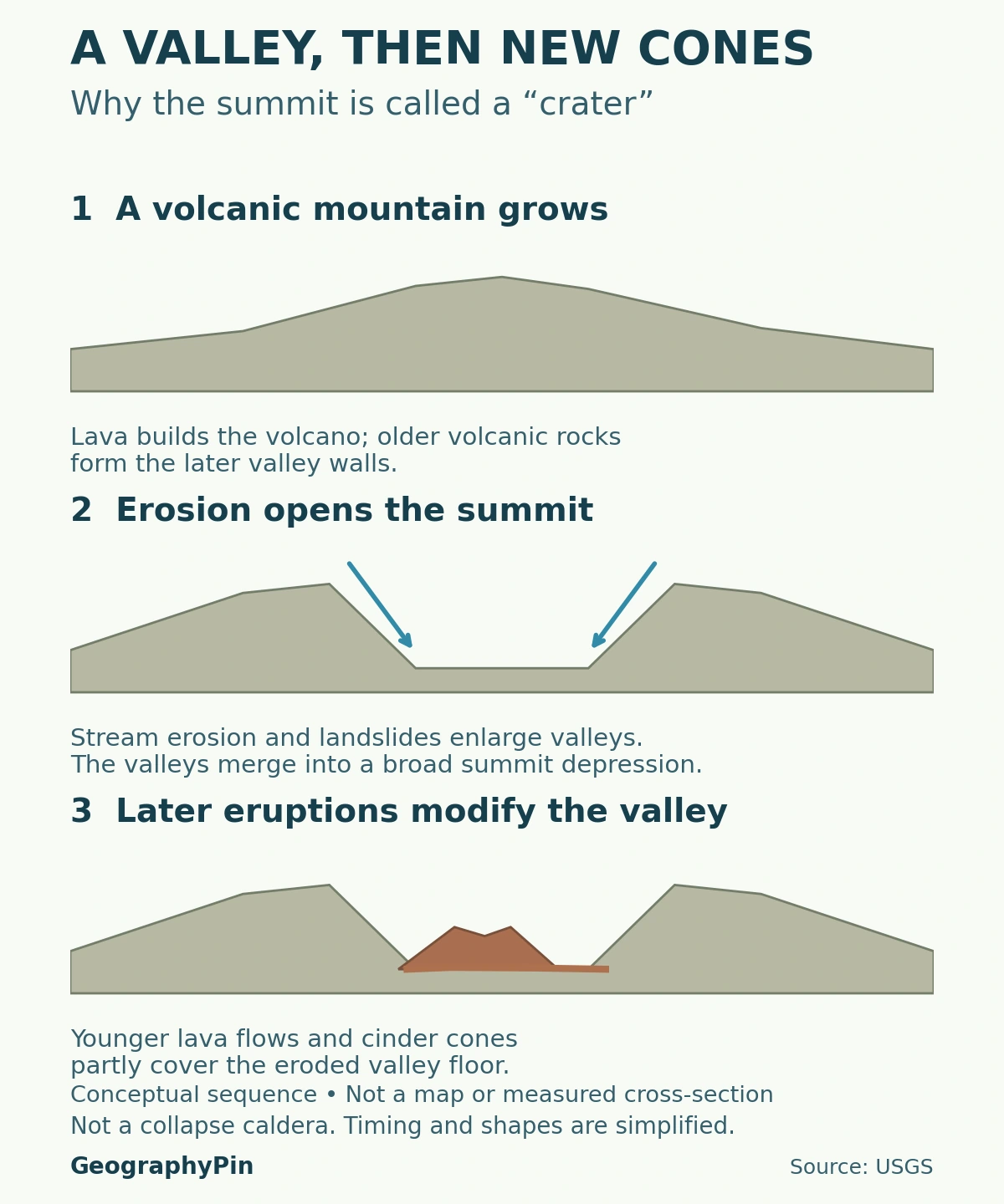
Valleys opened the summit; later lava partly filled it
Koʻolau Valley extended into the mountain from the north, while Kaupō Valley approached from the south. Stream erosion and landslides helped enlarge these openings. USGS considers a major south-flank landslide a probable contributor to the development of Kaupō Gap; the northern opening developed through repeated erosion and smaller slope failures.
The sequence was gradual and complicated. Geologists cannot assign one precise birthday to the whole depression because erosion removed parts of the evidence. The broad hollow likely enlarged in stages rather than appearing as a finished bowl in a single event.
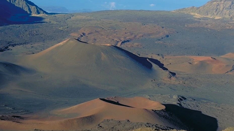
Later eruptions placed lava flows and cinder cones inside the eroded landscape. Those deposits partly filled the valley, so the present floor records both removal and renewed volcanic construction. The cones are genuine volcanic landforms even though the much larger depression around them has an erosional origin.
Small craters inside a much larger depression
A cinder cone builds around an eruptive vent as fragments of lava fall nearby. A cone can have its own crater at the top. On Haleakalā, that local volcanic feature is nested within a summit-scale landscape shaped by different processes. The two uses of “crater” describe different sizes and different histories.
The diagram separates these processes conceptually. It is not a reconstruction of an exact ancient skyline, a measured cross-section or a claim that all erosion ended before every later eruption.
4. An Old-Looking Landscape on a Volcano That Is Not Extinct
Haleakalā is a shield volcano: repeated lava flows built a broad volcanic mass. It is now in the postshield stage, a geological description of its development rather than a statement that it can no longer erupt. USGS records repeated eruptions during the past thousand years.
The youngest activity did not occur everywhere on the mountain at once. Young flows and cones are distributed along rift zones, elongated zones where eruptions have occurred. Some relatively young deposits lie on the lower flanks, far from the summit visitor area.
The latest eruption was centuries ago on the lower southwestern flank. That should not be retold as a recent eruption of the great summit depression. Published age estimates are ranges, not a securely observed calendar date, and a long interval without an eruption does not make Haleakalā extinct.
For present volcanic conditions, the appropriate reference is the USGS Haleakalā page and its volcano updates. An evergreen geography profile cannot replace monitoring, and the park’s appearance on a particular day does not predict when an eruption will occur.
5. Elevation, Moisture and Habitats Change Across the Mountain
The high summit and Kīpahulu coast are parts of one mountain, but they do not share one uniform climate. NPS describes cold, rapidly changing summit conditions, strong sunlight and moving clouds. At the eastern coast, ocean influence and trade winds contribute to a milder, wetter setting.
Altitude matters, but so do exposure and moisture. These connections between landforms, climate and living organisms are central to physical geography. An island forecast or a sunny beach is not a reliable description of the summit. Conversely, the sparse-looking high volcanic landscape does not represent the wet forests farther down the mountain. Weather can change quickly in either district.
Bare-looking ground can still be sensitive habitat
Near the summit, the ʻāhinahina, or Haleakalā silversword, is a recognizable example of a plant adapted to this environment. NPS warns that footsteps can damage its fragile roots. Staying on established paths protects more than the plants immediately visible beside the trail.
Elsewhere, native shrubland, forest and wet upper-valley habitats support organisms shaped by Hawaiʻi’s isolation. The park’s nature guidance emphasizes how introduced grazers, predators and diseases threaten these ecosystems. The biological reserve protects habitat that cannot be understood as simply unused land awaiting visitor access.
This makes conservation a geographic issue as well as a species issue. Where trails run, which areas remain restricted and how habitats connect across the mountain all affect what the protected landscape can sustain.
6. A Cultural Landscape, Not an Empty Mountain
Haleakalā’s summit is sacred to Native Hawaiians. NPS describes it as a place associated with pilgrimage, ceremony, navigation through the study of stars and the making of stone tools. Its significance is not limited to the scenery that appears in a sunrise photograph.
The volcanic rock itself connects physical and cultural geography. Skilled adze makers selected suitable stone, while coastal communities were linked to activities higher on the mountain. Archaeological traces and present-day cultural relationships give the landscape meanings that a landform map alone cannot convey.
At Kīpahulu, NPS also explains the importance of ahupuaʻa, traditional land divisions connecting mountain and coastal resources. These relationships help explain why water, uplands and shore are considered together. Respecting the place includes leaving rocks and cultural features undisturbed and following access rules, not only choosing the right route.
7. What the Geography Means for Access
Choose the district before choosing a destination in a navigation app. NPS directs summit traffic through Routes 37, 377 and 378. The approach to Kīpahulu follows Routes 36, 360 and 31. These are separate approaches around and up the mountain, not a road crossing through the summit depression.
Use the official directions together with current park alerts. Closures and reservations are operational conditions, not permanent features of a locator map. The map in this article is for geographic orientation, not turn-by-turn navigation or permission to enter restricted areas.
Waterfalls do not imply swimming access
NPS does not allow entry to the Pools of ʻOheʻo because of safety concerns. The park also warns about flash floods and rockfalls and advises against entering or wading in streams. A photograph of clear water, or an older travel description calling the pools a swimming spot, does not override those warnings.
Keep the two districts’ practical differences in mind: exposed high-elevation conditions at the summit, wet stream-and-coast terrain at Kīpahulu, and protected places that are not open for recreation. Check the relevant official district page rather than assuming every area inside the park boundary has the same visitor access.
What Did We Learn Today?
The national park, East Maui volcano and the summit depression are different geographic features. Summit and Kīpahulu visitors use separate road approaches. Erosion opened the great summit valley, and later lava and cones partly filled it. Elevation, moisture, native habitats and Hawaiian cultural relationships make the park more than a single overlook.
Sources & Data Notes
The summit elevation refers to Puʻuʻulaʻula, not the floor of the depression. “Crater” is retained as a familiar place name while its erosional origin is explained. The formation sequence is conceptual, not a dated reconstruction. Separate district access does not mean that every part of the park is open to visitors. Consult NPS alerts and USGS updates for changing conditions.
- USGS: Haleakalā volcano and monitoring
- USGS: Geology and History of Haleakalā (2023)
- NPS: geology of the summit valley, lava and cinder cones
- NPS: Puʻuʻulaʻula elevation, silversword protection and observatory distinction
- NPS: separate district approaches
- NPS: Summit District
- NPS: Kīpahulu District and water-access warnings
- NPS: Kīpahulu Biological Reserve
- NPS: summit and coastal weather contrasts
- NPS: native ecosystems and conservation
- NPS: summit cultural landscape
Featured photograph: Haleakalā’s summit valley and cinder cones, looking toward Koʻolau Gap. Photo: USGS, public domain. Cropped and converted to WebP. No claim is made to the original U.S. Government photograph.
Map methods: The National Park Service Land Resources Division’s official HALE boundary feature, edited September 17, 2025, is preserved with its source components and interior rings. It is a park-unit boundary, not a parcel-ownership map or a statement of public access. The locator uses a generalized Natural Earth coastline, the OpenStreetMap Haleakalā Visitor Center building and the NPS Kīpahulu Visitor Center meeting location, projected in WGS 84 / UTM zone 4N. Markers locate visitor centers, not the summit elevation or district centroids. The map is not a legal survey; see the NPS use notice.
Diagram methods: The original illustration simplifies the USGS erosion-and-eruption sequence. It does not assign fixed dates or durations to the stages, reconstruct an ancient skyline, or imply that erosion stopped when later eruptions occurred.