Lake Mungo is a lake you recognize by its basin and former shore, not by a blue patch of water. Its broad dry floor and pale eastern dune preserve different parts of a long environmental history. Reading those landforms together explains why this inland New South Wales landscape matters, while remembering that it remains living Country for its Traditional Owners.
Lake Mungo is an ancient dry lake basin in southwestern New South Wales, Australia, within the Willandra Lakes cultural landscape. Its eastern lunette, including the Walls of China, records changing lake conditions and windblown sediment. The dry basin, Mungo National Park and the wider World Heritage property are related places, not identical boundaries.
How to use this article: Distinguish the lake, park and wider landscape, read the environmental sequence, or compare satellite and ground perspectives.
1. Locate the dry lake, park and Willandra landscape
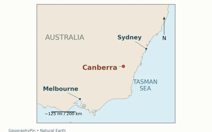
Lake Mungo lies inland in southeastern Australia, in the southwestern part of New South Wales. It belongs to the Willandra Lakes system, whose former lake basins are now a prominent part of a semi-arid landscape. A locator is useful here because “Lake Mungo,” “Mungo National Park” and “Willandra Lakes Region” often appear together in travel descriptions even though they refer to different geographic units.
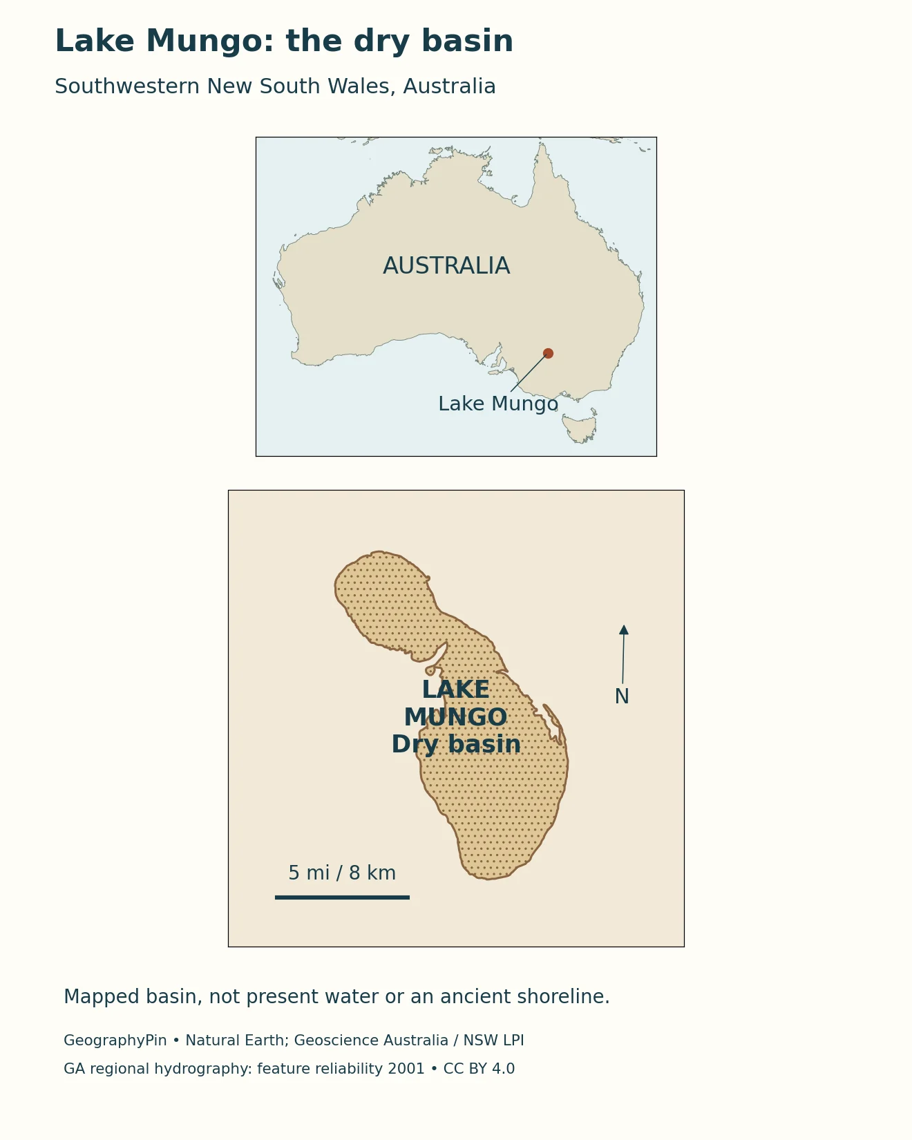
Three names, three different extents
Lake Mungo is the physical basin. Mungo National Park is a protected area with its own boundary and management arrangements. The Willandra Lakes Region World Heritage property is a wider cultural and natural landscape containing several former lakes and their surrounding landforms. A park entrance, a lake outline and a World Heritage boundary should not be read as interchangeable markers.
The Australian Government describes the World Heritage property as approximately 927 square miles (2,400 square kilometers). That is not the area of Lake Mungo. Its account also notes a boundary modification in 1995, which helps explain why an older property description may quote a different regional area. Use the name and date attached to a measurement rather than transferring a large regional figure to the individual lake.
The locator shows a mapped dry-basin outline, not an ancient waterline reconstructed for one particular year. Water occupied different levels during the lake’s history. A modern cartographic feature can locate the depression without telling us exactly how far water extended during every earlier phase.
2. Why an ancient lake can be dry today
The Willandra landscape preserves the remains of a lake system whose water supply and losses changed over time. Lake Mungo was not simply a permanently full lake that emptied in a single event. Sediments in its lunette record repeated changes in water level, with different deposits and soil-forming intervals marking different conditions.
A 2020 study by Barrows and colleagues reconstructed lake-level history using dated sediment sections. Their results describe generally wetter conditions than today from shortly after about 60,000 years ago until roughly 19,000 years ago, interrupted by fluctuations. The final phase included several short-lived lake-level events rather than one uniform highstand. Those approximate ages describe a scientific reconstruction; they are not precisely dated shoreline photographs.
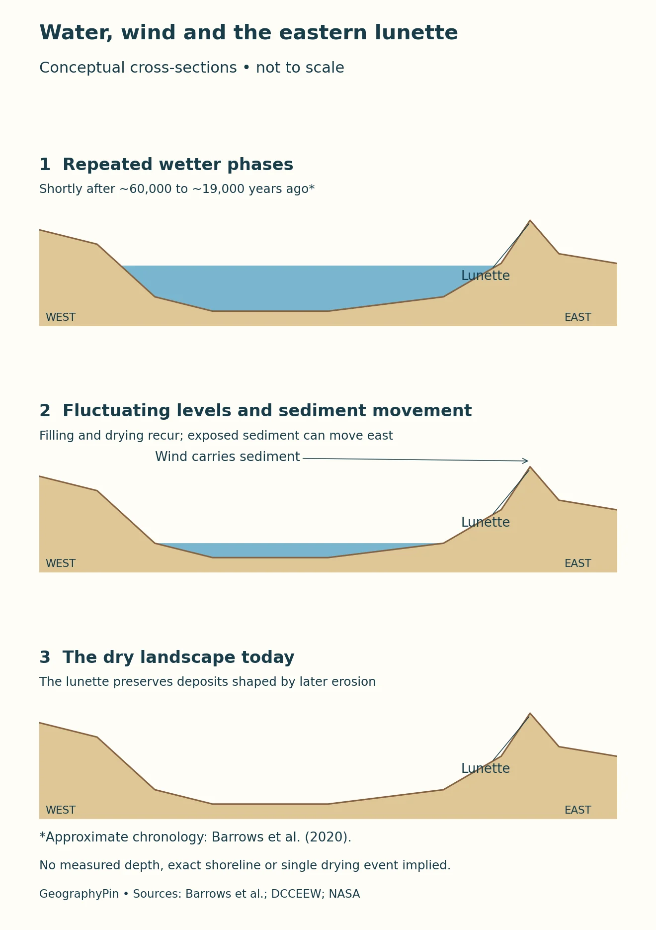
Read the sequence, not a single ancient shoreline
The conceptual diagram separates wetter and fluctuating phases from the dry landscape of the present. It does not assign a surveyed water depth or a geographic shoreline to its schematic basin. A cross-section can explain the relationship between water, sediment and wind without pretending to reproduce a measured lake profile.
The broader Willandra lakes also did not all dry simultaneously. The Australian Government describes their drying as a sequence through the lake system. A regional summary date and a lake-specific sediment chronology therefore answer slightly different questions. The useful conclusion is a transition through changing hydrological conditions, not that every depression crossed the same threshold on the same day.
3. How the lunette and Walls of China formed
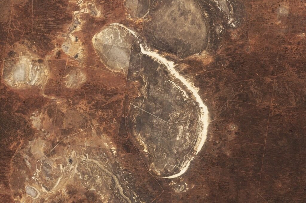
The pale crescent along Lake Mungo’s eastern side is a lunette: a dune-like accumulation associated with the downwind margin of the basin. Its position matters. It is not a ring of rock mountains enclosing the lake, and the name “Walls of China” does not describe a built wall. Wind, sediment deposition and later erosion produced the distinctive forms.
Sand and finer sediment accumulated under changing environmental conditions. Layers within the lunette preserve evidence of those changes, while erosion has cut and exposed parts of the deposit. The visible ridges, gullies and sculpted surfaces are therefore not all the same age as the material from which they are made. An old sediment deposit can acquire a much younger exposed surface.
NASA’s October 21, 2024 Landsat 9 image shows the large eastern crescent clearly. Its accompanying account describes the lunette as about 19 miles (30 kilometers) long. That is the length of a landform, not the lake’s circumference, depth or a walking-route distance. The image also shows abrupt differences across nearby land-use boundaries; the color changes are not all ancient shorelines.
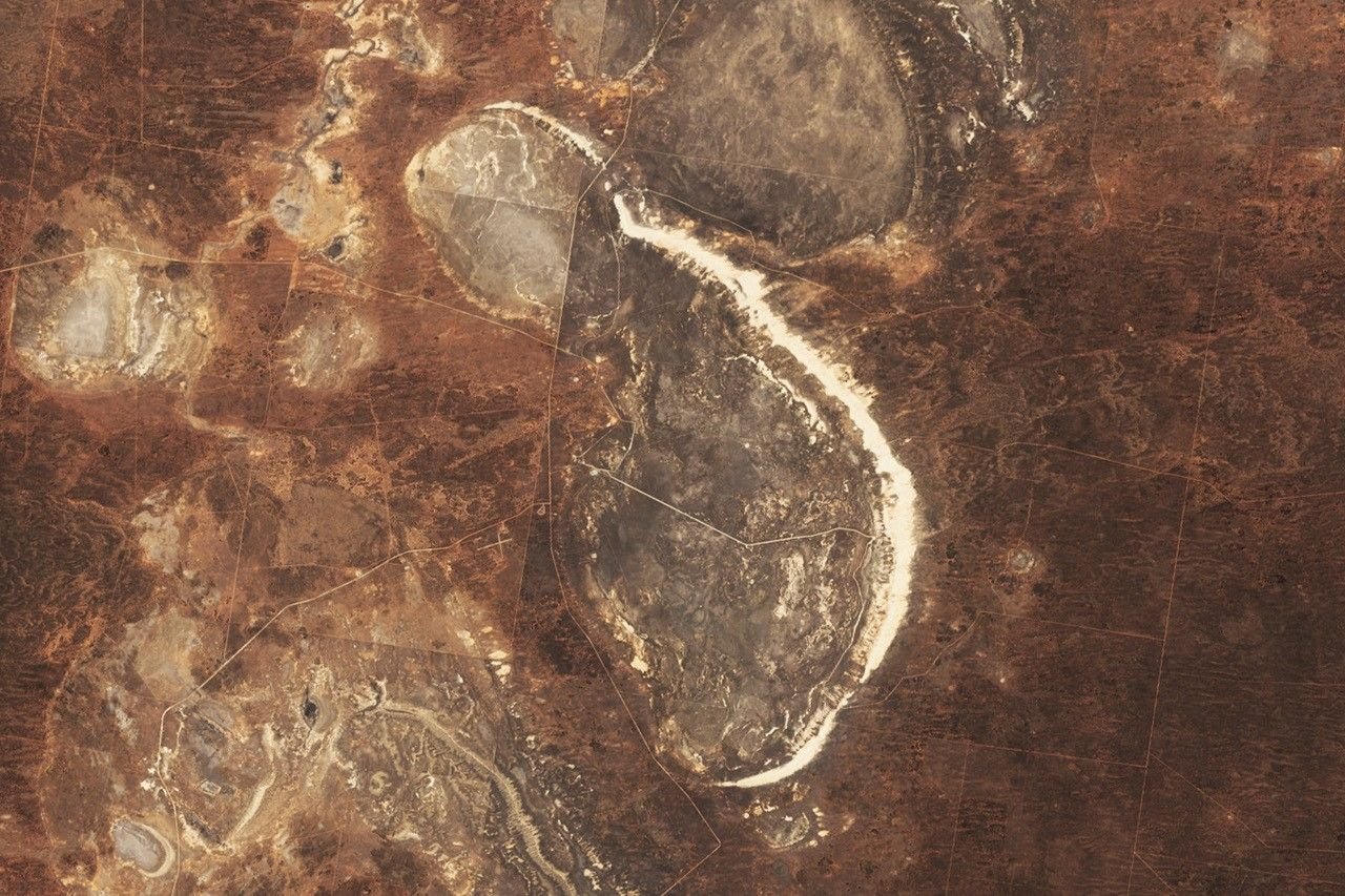
A satellite view and a ground view reveal different things
From above, the basin’s shape and the lunette’s position are easier to see. From designated viewing areas, the exposed layers and erosion forms become more apparent. Neither view alone supplies the full chronology: interpreting the sequence requires field observations and dating, not just matching a pale line to a presumed former coast.
4. Keep the measurements attached to their meaning
For an ancient dry lake, the most useful facts are often about extent, observation dates and interpretation rather than a present water volume. A conventional lake fact box can mislead if it gives a single “depth” without saying whether that means an ancient water depth, basin relief or the thickness of sediment.
| Reference | Value or date | What it describes |
|---|---|---|
| World Heritage property | About 927 sq mi (2,400 km²) | The wider Willandra property, not Lake Mungo; boundary modified in 1995 |
| Eastern lunette | About 19 mi (30 km) long | Landform length reported with NASA’s 2024 image, not a walking distance |
| Wetter interval in the 2020 reconstruction | Shortly after about 60,000 to about 19,000 years ago | Approximate period with fluctuations, not one constant shoreline |
| Satellite observation | October 21, 2024 | Landsat 9 surface observation, not live conditions |
The figures in this table concern different things and should not be added or compared as if they were equivalent lake measurements. In particular, the World Heritage property’s area belongs to a conservation designation, while the approximate lunette length belongs to a physical landform. The 2024 image documents a historical observation of the surface, not a claim about today’s road conditions or every part of the park.
A map scale measures horizontal distance on the map. It does not establish ancient water depth. Likewise, a reconstruction labeled “about 19,000 years ago” should retain its approximation. Scientific chronologies are interpretations of dated evidence with uncertainty, not calendar dates accurate to the year.
5. A cultural landscape with living custodians
The geographic story is inseparable from Aboriginal relationships with Country. NSW National Parks identifies the Barkindji, Mutthi Mutthi and Ngyiampaa peoples in its account of Mungo’s joint management. Their involvement is not just a historical footnote: Traditional Owners continue to participate in caring for the park and interpreting its significance.
The park’s formal joint-management arrangements began in 2001, and the Willandra Lakes Aboriginal Advisory Group was established in 2015. These institutional dates are different from the much deeper history preserved in the landscape. They help explain who participates in decisions today rather than defining when cultural connections began.
The sediments and cultural evidence make the Willandra landscape internationally important, but a visitor map is not an invitation to locate, handle or collect heritage material. Ancestral remains and archaeological locations are not marked on this locator. Learn through the visitor centre, designated interpretation and Aboriginal-guided experiences rather than treating exposed material as something to investigate independently.
The World Heritage designation recognizes both cultural and natural values. Keeping those values together avoids two misleading extremes: presenting Mungo as an empty desert without people, or treating its environmental history as merely scenery behind an archaeological story. Country, landforms and continuing care belong in the same explanation.
6. Use the landscape respectfully when planning a visit
Start with the park’s current visitor information and alerts. NSW National Parks describes access to the Walls of China viewing platform as unsealed and suitable in dry weather. Conditions can change, so a published map or an old photograph does not guarantee that a road, walking route or tour is available on the day you travel.
The viewing platform and boardwalk are different from unrestricted access across the lunette. Follow signed routes and current park guidance; use an authorized guided tour for experiences beyond public viewing areas where required. An NPWS Aboriginal-guided lunette tour offers interpretation of the landscape as well as access under the relevant arrangements.
The park also restricts drone use. Its published visitor guidance requires prior written agreement, granted only in exceptional circumstances with Traditional Owner endorsement. Do not assume that a scenic destination is open for aerial filming. For ordinary photography, respect signs, other visitors and cultural guidance, and leave objects and surfaces undisturbed.
The geographic reason for this care is visible in the landforms themselves: fine sediments can preserve a long record while also being vulnerable at the surface. A photograph taken from a permitted viewpoint can communicate the landscape without crossing a fragile formation or publicizing a sensitive location.
What Did We Learn Today?
Lake Mungo is an ancient dry basin, not a present-day blue-water lake, and it is distinct from both the national park and the larger Willandra World Heritage property. Its eastern lunette preserves evidence of changing water and sediment conditions, while a dated satellite image shows the modern surface. Reading the landscape accurately means keeping measurements and reconstructions in context and recognizing the continuing role of Traditional Owners in caring for Country.
Sources & Data Notes
Dates distinguish reconstructed ancient conditions from the October 21, 2024 satellite observation. The wider World Heritage property is not the lake or national park boundary.
- Australian Government: Willandra Lakes Region
- UNESCO: Willandra Lakes Region
- Barrows and colleagues (2020): Late Pleistocene lake level history of Lake Mungo, author abstract
- NASA Earth Observatory: Lake Mungo, Landsat image from October 21, 2024
- NSW National Parks: Mungo joint management
- NSW National Parks: Walls of China viewing platform visitor information
- NSW National Parks: Mungo lunette guided tour
- NASA image and media reuse guidelines
- Geoscience Australia: Surface Hydrology regional polygons
- Creative Commons Attribution 4.0 license for the GA source
Approximate palaeolake dates follow the author abstract of the 2020 research article, not an exact annual chronology. The schematic explains environmental phases rather than reconstructing a measured waterline. Regional property area is not lake area. Visitor information can change; consult current NSW National Parks alerts and follow Traditional Owner and park guidance.
Locator: official Geoscience Australia regional surface-hydrology geometry identifies the mapped dry basin; the feature has a November 6, 2001 reliability date. It is not a contemporary water extent or a reconstructed ancient shoreline. Local detail uses WGS 84 / UTM zone 54S; the Australia context panel has its own scale. Adapted by GeographyPin from © Commonwealth of Australia (Geoscience Australia) 2016 and AusHydro contributors, including NSW LPI, under CC BY 4.0; continental context uses Natural Earth public-domain data. The conceptual cross-sections are not measured profiles. The approximate lunette length is converted from the source’s 30 kilometers to 19 miles.