A port, a factory cluster and a neighborhood shop all depend on connections extending beyond their immediate surroundings. Tracing those connections reveals why the same economic activity can develop differently in different places.
Economic geography studies where economic activity happens, how places are connected, and why opportunities and outcomes differ between locations. It examines production, work, trade and consumption through factors such as distance, transport, skills, resources, institutions and business networks. A port, a factory cluster or a local service can reveal how location shapes an economy without determining its future.
How to use this article: Explore the benefits of business clusters, Rotterdam and the Rhine corridor, how to test a location claim.
1. What Does Economic Geography Study?
An economic map is more than a map of wealthy and poor countries. It can show where people work, where materials are processed, how goods reach customers, or how one region depends on activity somewhere else. Economic geography asks why those patterns exist and how they change.
The field belongs within human geography. Its subject includes farms, mines and factories, but also finance, logistics, digital services, tourism and everyday retail. It studies connections within a town as well as networks crossing continents.
Consider a bakery as a hypothetical example. Its location may depend on customers, rent, delivery access, available workers and local rules. The flour may arrive from outside the neighborhood, while many customers come from nearby. The business is simultaneously part of a local market and a wider production network.
How is it different from economics? Economics and economic geography overlap substantially. The useful distinction is emphasis, not a rigid boundary: economic geography puts places, spatial relationships and regional differences at the center of the question. Economists also study these matters, especially in regional, urban and international economics.
2. Why Location and Distance Matter
Two places can be close on a map yet costly to connect. A mountain crossing, missing transport link, border procedure or unreliable service can matter more to a particular shipment than straight-line distance. Conversely, a longer journey on a dependable connection may be more useful than a shorter but uncertain one.
Market access means more than being near a large population. The relevant questions include who can buy the product, whether it can reach them, and what the journey costs in money and time. Access to suppliers and workers matters too.
Different activities weigh these factors differently. A hypothetical neighborhood repair shop needs a reachable local clientele. A specialized component producer may care more about dependable deliveries to other firms. A business requiring particular skills may accept higher premises costs to reach an appropriate workforce. There is no single best location for every industry.
- Resources and infrastructure: suitable land, energy, water and transport can enable an activity.
- Workers and capabilities: relevant skills and experience affect what firms can do.
- Institutions: rules, public services and arrangements for doing business influence how connections function.
- Existing relationships: suppliers, customers and accumulated knowledge can make an established location valuable.
These factors interact. A transport link does not create a suitable workforce by itself, and a resource deposit does not guarantee that local residents receive lasting benefits. Geography helps identify opportunities and constraints; it is not a formula that turns location into prosperity.
3. Why Businesses Cluster, and Why Clustering Has Limits
Sharing, matching and learning
Agglomeration means the geographic concentration of economic activity. Benefits associated with proximity are often explained through three mechanisms. Firms can share access to specialized suppliers or facilities; workers and employers can find more suitable matches; and knowledge can circulate through professional contacts and interaction. Gilles Duranton’s research review distinguishes these mechanisms while emphasizing the difficulty of establishing their causal effects.
A cluster is not simply a collection of neighboring buildings. The important question is whether proximity creates useful relationships. Firms in the same sector may benefit from specialized connections, while a diverse city can bring different activities together. Neither pattern guarantees that every firm or worker benefits equally.
Density alone is not a development strategy
Concentration can coexist with congestion, expensive space and difficult journeys. A World Bank study of Latin America and the Caribbean describes a regional productivity problem in which dense cities have not automatically delivered strong productivity performance. Its analysis emphasizes economic restructuring, weak connections and divisions within cities. These are findings about the region studied, not a universal verdict on every large city.
The practical lesson is to investigate the connections beneath the density. A crowded district and a well-functioning network of workers, firms and services are not the same thing. Simply adding businesses to a map does not show that they share suppliers, exchange knowledge or recruit from the same labor market.
4. Worked Example: Rotterdam and the Rhine Corridor
A coastal gateway linked to an inland port
Rotterdam in the Netherlands provides a concrete example of a seaport connected with inland destinations. The Port of Rotterdam describes inland shipping links through the Rhine, Maas, other rivers and canals. This is not just a coastal location: the useful geographic relationship extends inland.
Duisburg, in Germany, is one inland example. The European Investment Bank’s account of the port describes Rhine connections with Rotterdam, Amsterdam and Antwerp. These connections illustrate how an inland port links water transport with other logistics activities. The cited 2017 account describes an earlier investment project, not today’s cargo volumes.
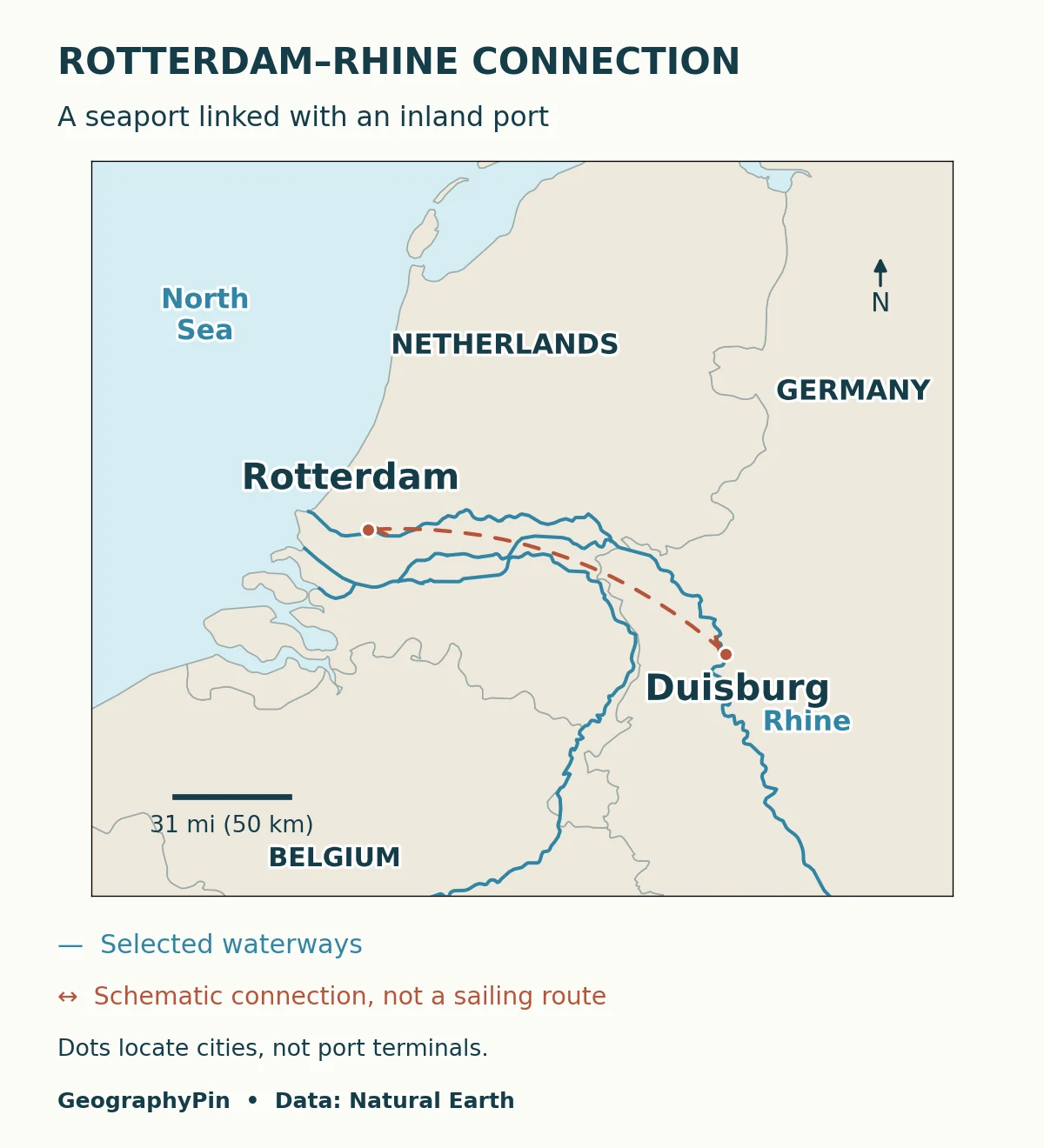
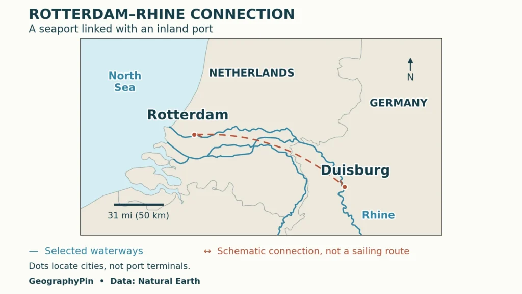
The locator shows Rotterdam and Duisburg city reference points, country context and selected waterways. City points are not individual terminal entrances. The connecting line is schematic: it does not trace a vessel’s journey, represent cargo volume or establish that all firms along the corridor trade with each other.
| Documented evidence | Geographic interpretation | What it does not establish |
|---|---|---|
| Rotterdam has inland waterway connections | A seaport can serve destinations beyond its coastal area | The cheapest option for every shipment |
| Duisburg is connected to seaports by the Rhine | An inland node links with wider transport networks | That transport alone explains every firm’s location |
| Low water can constrain vessel loading | Physical conditions affect a network’s usable capacity | A fixed annual loss or a current disruption |
The connection also has physical limits
A river on a map does not provide identical transport conditions all year. A CCNR reflection paper on Rhine navigation explains how low navigable water depth can limit cargo-carrying capacity and affect voyage conditions. The paper was prepared following a 2019 workshop and updated in 2021; it is used here to explain the mechanism, not to describe today’s river conditions.
That distinction matters economically. The existence of a link and the capacity available on a particular day are different facts. To compare actual transport costs, a researcher would need the cargo, origin and destination, terminal handling, available alternatives and relevant operating conditions. A line between two ports cannot supply that information.
5. Production Networks and Uneven Benefits
A product does not necessarily belong to one place throughout its life. The OECD describes global value chains as production arrangements in which activities such as design, manufacturing, assembly and distribution are spread across economies. The connections can involve components and services, not only finished goods moving to a customer.
A simple teaching chain might place design, component production, assembly and retail in different locations. That is an illustration, not a claim that every product follows the same sequence. Real networks can branch, involve multiple suppliers, and include repair or reuse. Physical movement and the creation of value are related but not identical.
This helps explain why a busy transport corridor is not a complete picture of who benefits. A place might handle goods without performing all the higher-paid or decision-making activities associated with them. Another may host important services while moving little physical cargo.
Regional inequality therefore needs more than a map of output. Ask where jobs are located, who can reach them, what skills they require, and what households receive after local living costs. Also ask who bears environmental or infrastructure burdens. A national average can conceal differences between regions, and a regional average can conceal differences between neighborhoods.
No single indicator answers every question. Employment measures jobs or workers, productivity concerns output relative to inputs, and household income concerns resources reaching households. Comparing these measures can be useful, but treating them as interchangeable can produce misleading conclusions.
6. How to Investigate an Economic Geography Question
Move from a pattern to a testable explanation
Start with a precise question, such as whether access to a particular transport connection helps explain where a type of business operates. Identify the locations, period and activity being compared. Then distinguish the evidence you can observe from the mechanism you propose.
- Choose matching units. A municipality, metropolitan region and country represent different scales. Avoid mixing them without explanation.
- Check what is counted. A registered headquarters is not necessarily a factory, and a shipment’s declared origin may not describe every production stage.
- Measure the relevant connection. Straight-line distance, journey time and delivery cost are different variables.
- Compare plausible alternatives. Skills, land availability, past investment and institutions may help explain the same pattern.
- State the remaining uncertainty. A cluster beside a port does not, by itself, prove that the port caused the cluster.
Interviews, business records, transport data and historical maps can answer different parts of the question. Their dates and definitions matter. A careful explanation may be narrower than an eye-catching claim, but it is more useful: it tells the reader what the evidence supports and what still needs testing.
Frequently Asked Questions
Does economic geography only study international trade?
No. It also studies local and regional relationships, including neighborhood services, labor markets and connections between rural and urban areas. International trade is one scale of analysis, not the whole field.
Does online business make location irrelevant?
No. Some activities can reach customers without shipping a physical product, but workers, infrastructure, legal arrangements and service availability still have locations. The useful question is which spatial constraints have changed, rather than whether geography has disappeared.
Can a resource-rich region still have low household incomes?
Yes. Resource extraction and household well-being measure different things. To understand their relationship, examine employment, ownership, public revenue, local services, costs and how benefits are distributed instead of assuming that the presence of a resource settles the question.
What Did We Learn Today?
Economic geography connects places with the activities and relationships that sustain them. Distance matters through usable connections, clustering matters through actual interactions, and a production network can distribute work and benefits across many locations. Rotterdam and the Rhine illustrate these relationships without proving that a transport link guarantees low costs or prosperity. The strongest explanation separates a mapped pattern from the evidence needed to explain it.
Sources & Data Notes
The port example documents connections, not current freight prices, shipment volumes or a causal estimate of clustering benefits. Historical methodological sources are used for concepts, not current rankings. The locator uses generalized Natural Earth geography and city reference points; its schematic connection is not a navigational route or cargo-flow measurement.
- Port of Rotterdam: inland shipping connections
- European Investment Bank: Duisburg’s port connections
- CCNR: Act Now! Low water and effects on Rhine navigation, 2021 edition
- Gilles Duranton: Growing through Cities in Developing Countries, 2014
- World Bank: The Evolving Geography of Productivity and Employment
- OECD: Interconnected Economies, 2013
- Natural Earth: public-domain map data and terms