Djibouti is small on a world map, but its position connects very different landscapes: a narrow maritime gateway, a deep gulf, volcanic highlands and salt-bearing depressions. Its capital and ports face the sea, while roads and railways connect them to the much larger inland markets of the Horn of Africa.
Djibouti is a country in northeastern Africa bordering Eritrea, Ethiopia and Somalia. Its capital is also called Djibouti. The country lies beside the Gulf of Aden and the southern approach to the Red Sea, near the Bab el-Mandeb strait. Its geography combines coastal plains, volcanic uplands and low-lying closed basins, including salt-rich Lake Assal. Maritime access and connections with landlocked Ethiopia help explain the importance of its ports.
How to use this article: Locate the Red Sea gateway, compare the main landscapes, or distinguish the country from its capital region.
1. Locate Djibouti at the Red Sea gateway
Djibouti occupies part of the Horn of Africa near the southern entrance to the Red Sea, across the water from the Arabian Peninsula. Eritrea lies to the north, Ethiopia to the west and southwest, and Somalia to the southeast. Yemen lies across the water rather than across a land border.
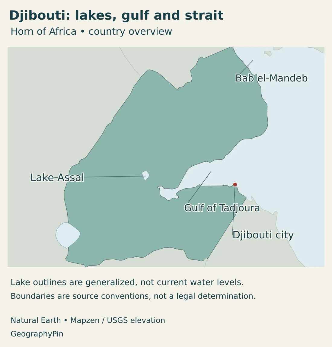
The Gulf of Tadjoura cuts deeply into the country from the east. Djibouti city stands on its southern side near the gulf’s entrance. Farther inland, the narrow Ghoubbet connection leads toward the volcanic landscape separating the sea from the Lake Assal depression.
Why the Bab el-Mandeb matters
The Bab el-Mandeb connects the Red Sea with the Gulf of Aden and the wider Indian Ocean route. Djibouti’s northern coast lies close to its African approach. This is a maritime gateway, not a canal built across the country.
Ships using the Red Sea route can continue toward the Suez Canal and Mediterranean. A restriction at this gateway can therefore affect journeys far beyond Djibouti itself. The importance comes from the arrangement of seas and coastlines, not from the country’s size or population.
Our Red Sea map explains those sea connections in more detail. The East Africa countries map places Djibouti within the Horn and its neighboring inland regions.
2. Country facts with dates and scope
| Measure | Value | Date or scope |
|---|---|---|
| Capital | Djibouti city | The city and the country share a name. |
| Population | 1,066,809 | Final 2024 census: resident population at May 20, 2024; published June 2025. |
| Surface area | About 8,960 sq mi (23,200 km²) | UN-published surface area, reference year 2023; not a new shoreline survey. |
| Official languages | Arabic and French | Official status does not describe all everyday language use. |
| Currency | Djibouti franc (DJF) | National currency. |
| Regional census units | Djibouti-Ville and five other regions | Ali Sabieh, Arta, Dikhil, Obock and Tadjourah. |
| Government | Republic | National institutions are distinct from regional administration. |
A country population and a capital-region population answer different questions. Djibouti is the name of both the sovereign state and its capital, while census tables also identify a Djibouti-Ville region. A regional count should not automatically be described as the population inside a continuously built-up city boundary.
The area figure in the table is a published national surface-area reference. It is not a new measurement of shorelines or a map of present-day lake water. Lake levels, salt crusts and occasionally flooded ground need observations with their own dates.
3. Coastal plains, volcanic uplands and Lake Assal
The main landscape contrasts
| Setting | Landscape | Geographic significance |
|---|---|---|
| Coast and Gulf of Tadjoura | Coastal plains, bays and steep-sided stretches around the gulf. | Maritime access, ports and the capital contrast with a largely dry interior. |
| Volcanic uplands | Faulted ridges, plateaus and volcanic terrain. | Relief influences local climate, drainage and routes between settlements. |
| Lake Assal depression | A closed salt-lake basin below sea level. | Evaporation and groundwater inputs create a saline setting rather than a freshwater reservoir. |
| Western inland basins | Dry valleys and depressions toward the Ethiopian frontier, including shared Lake Abhe. | Some drainage ends inland instead of reaching the sea. |
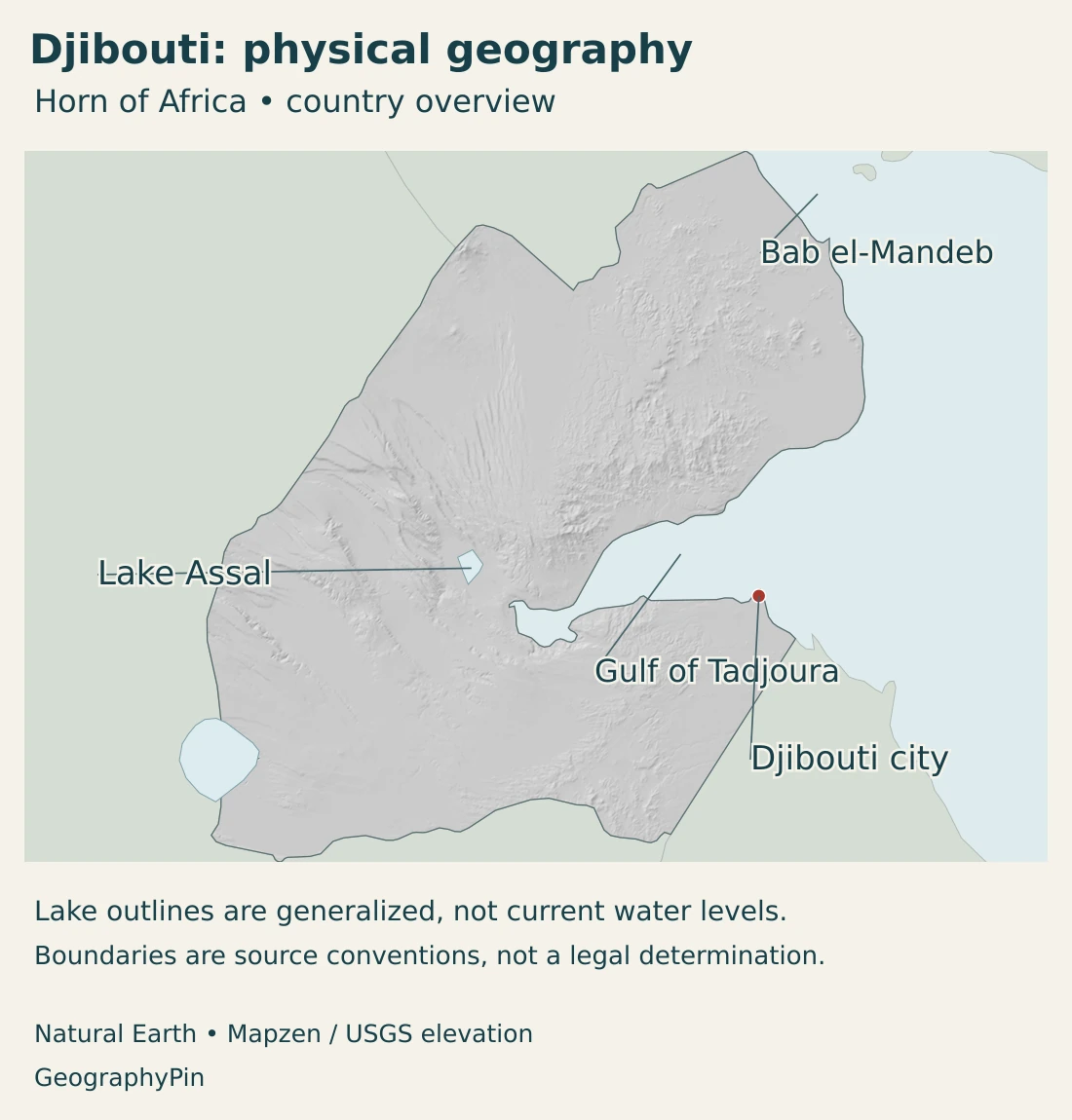
Much of Djibouti’s terrain reflects extension within the Afar region, where the East African rift system meets the Red Sea and Gulf of Aden systems. Faulting and volcanism have helped produce abrupt changes between elevated blocks and depressed basins.
This does not mean that every part of the country is erupting or that a new ocean will appear on a predictable human timetable. Plate motion describes a long-term process. Individual earthquakes and volcanic events require their own monitoring and cannot be inferred from a simple national map.
Lake Assal: low elevation does not mean freshwater
Lake Assal’s surface lies roughly 500 feet (150 meters) below sea level. It occupies a closed depression, separated from the nearby sea by volcanic terrain. Its setting is therefore very different from an ordinary coastal inlet.
Water reaches the basin through springs, groundwater connections and irregular surface inflows. Strong evaporation removes water while leaving dissolved salts behind. Salt deposits around the lake are part of this water balance, not evidence that the basin contains an abundant freshwater supply.
Elevation and salinity describe different properties. A lake can lie below sea level without having the same salinity as seawater, and its salt concentration can change with water inputs and evaporation. A precise salinity comparison needs a dated measurement and a consistent method.
Lake Abhe, also written Abbe, lies farther southwest along the Ethiopian border. It is a separate inland lake system, not another name for Assal or an arm of the Gulf of Tadjoura. These distinctions matter when comparing the country’s apparently similar lowland landscapes.
4. Dry climate, brief floods and scarce freshwater
Djibouti has a hot, dry climate, but aridity does not mean that rain never falls. Rainfall is irregular, and short intense storms can produce substantial runoff. Higher ground can have different local conditions from the exposed lowlands and coast.
The country has no perennial rivers. Wadis may remain dry for long periods and then carry water after rain. Some drain toward the coast; others lead into inland depressions. A channel visible on a map should therefore not automatically be interpreted as a year-round flowing river.
Why drought and flooding can coexist
A storm can deliver more water than dry ground and drainage infrastructure can absorb quickly. Floodwater may pass through a settlement without becoming a dependable supply for the following dry months. Drought and flash flooding are consequently different parts of the same water-management challenge.
Groundwater is especially important away from the major urban network. Fractures in volcanic rocks and deposits along drainage channels can hold or transmit water, but wells differ in yield and quality. Salinity, limited recharge and excessive abstraction can make a source unsuitable or less reliable.
The World Bank’s 2026 rural-water project identifies maintenance and groundwater management as part of the response, alongside restoring and extending water systems. Building a borehole is only one step: operating pumps, protecting recharge areas and keeping equipment working determine whether the supply remains useful.
Urban water supply has a different infrastructure mix, including desalination and a pipeline connection from Ethiopia. These systems connect the coastal city’s needs to energy, treatment facilities and cross-border infrastructure rather than to a large local perennial river.
Pastoral livelihoods are also sensitive to where and when rain falls. In a July 2025 assessment, FAO reported that poor seasonal rains in inland areas had affected pasture and water for livestock. That is a dated example of the connection between climate and livelihoods, not a claim that identical conditions prevail every year.
5. Djibouti city, regional settlement and languages
The country, the capital and Djibouti-Ville
Djibouti city is the national capital and the main focus of urban services and transport activity. Its coastal position connects government and commercial functions with port facilities and inland corridors. It should nevertheless be distinguished from the entire country bearing the same name.
The final 2024 census counted 767,250 residents in the Djibouti-Ville region, about 71.9% of the national total. This is an administrative-region figure, not a separately measured built-up-city population. It demonstrates the strong concentration around the capital without implying that every resident lives inside one continuous urban footprint.
The other census regions are Ali Sabieh, Arta, Dikhil, Obock and Tadjourah. They include settlements and surrounding territories with very different combinations of coast, upland and dry inland terrain. A national average can conceal these differences in access to water, roads and services.
Official languages and everyday communication
Arabic and French are the official languages. Somali and Afar are also important languages of everyday life and community identity. Official status describes the legal and institutional role of a language; it does not mean that all residents use the same language in every setting.
For a fuller explanation of those roles, see our guide to the official languages of Djibouti. The country profile provides the geographic context rather than repeating that language-focused article.
6. Government, ports and inland connections
Djibouti is a republic. Its national constitutional framework places executive leadership with the president, alongside a prime minister and government. National institutions should be distinguished from the regional units used to organize administration and report census results.
The country’s economic geography is strongly shaped by the relationship between its coast and the inland Horn of Africa. Port access gives landlocked Ethiopia a connection to maritime trade, while road and rail corridors link coastal terminals with inland destinations.
Those connections do not operate through geography alone. Border procedures, road condition, rail operations and cargo-handling infrastructure affect how effectively a favorable location can be used. A narrow coastal gateway needs reliable inland links as well as deep-water access.
A 2026 World Bank corridor project illustrates this relationship: planned improvements to the Djibouti–Addis southern corridor include road rehabilitation, drainage and measures addressing heat and intense rainfall. Planned upgrades should not be confused with an already completed transport network.
Outside the main urban and logistics concentration, livelihoods include livestock keeping and other activities adapted to scarce and variable water. The contrast is important: a national economy connected to global shipping still contains communities whose immediate concerns are pasture, water points and local access.
Djibouti’s geography is best understood through these connections. The Bab el-Mandeb gives the coast international significance; the Gulf of Tadjoura shapes local coastal space; volcanic relief and closed basins shape the interior; and transport corridors connect this small country with a much larger region.
Frequently Asked Questions
Is Djibouti a country or a city?
Both. Djibouti is an independent country, and Djibouti city is its capital. Census figures for the Djibouti-Ville region describe an administrative area, not automatically the built-up city alone.
Is Lake Assal connected to the sea as an open bay?
No. It is a closed inland depression separated from the nearby sea by volcanic terrain. Groundwater connections and other inflows are different from an open surface channel forming a coastal bay.
Does Djibouti have rivers that flow all year?
No perennial rivers are identified in the national hydrogeological overview. Wadis carry water intermittently after rainfall, while groundwater and engineered supply systems are important sources of usable water.
What Did We Learn Today?
Djibouti combines a strategic coastal location with a dry, varied interior. Its capital and ports connect the Horn of Africa to maritime routes, while faulted uplands and closed basins explain landscapes such as Lake Assal. Water scarcity and occasional flooding are compatible, and a capital-region population should not be confused with a built-up-city count.
Sources & Data Notes
Reviewed in November 2026. The population is a dated final census count, not a 2026 estimate. Capital-region and built-up-city boundaries are different measures. Lake elevation is rounded; water extent and salinity require separately dated observations.
- Presidency of Djibouti, final RGPH-3 census results: June 17, 2025: 1,066,809 residents at May 20, 2024; Djibouti-Ville region 767,250, or 71.9%. Regional counts are not interchangeable with built-up-city estimates.
- United Nations Statistics Division, Djibouti profile: Surface area 23,200 km², reference year 2023; capital and currency. The area is reproduced as the source’s published surface-area measure without an additional land/water interpretation.
- Presidency of Djibouti, constitutional text: Republic, capital, official languages and executive framework; read together with subsequent amendments.
- Official Journal, 2025 constitutional revision: Amendments to the constitutional framework; provisions requiring subsequent institutional implementation are distinct from existing operations.
- U.S. Energy Information Administration, Bab el-Mandeb geography: 2019 reference for the strait’s sea connections and route significance.
- British Geological Survey, Hydrogeology of Djibouti: Intermittent drainage, groundwater, volcanic terrain and inland lake settings; hydrogeological overview rather than a current water-level survey.
- Geological Society, Afar triple junction: Scientific explanation of extension and the Afar triple-junction context, not an earthquake prediction.
- UNESCO World Heritage Centre, Lake Assal tentative-list entry: Djibouti’s January 2015 submission describes the closed basin, low elevation and saline setting. A tentative-list entry is not an inscribed World Heritage property.
- World Bank, Djibouti climate and development report: 2024 assessment of heat, drought, flooding, urban water infrastructure and regional economic connections.
- World Bank, rural water access project: March 16, 2026: groundwater management, maintenance and planned water-system improvements.
- FAO GIEWS, Djibouti country brief: July 9, 2025 assessment used for the dated example of rainfall, pasture and livestock-water conditions.
- World Bank, regional economic corridor: June 18, 2026: Djibouti–Addis corridor and planned road, drainage and resilience improvements.
- French Ministry for Europe and Foreign Affairs, Djibouti: Official Arabic and French, with Somali and Afar listed as national languages.
Map sources and scope: Original GeographyPin maps use public-domain Natural Earth country outlines, city coordinate attributes and lake polygons. Complete Djibouti source geometry is retained; offshore features are limited by the source scale. Lake polygons are generalized geographic references without a stated observation date, not current shorelines or measurements of lake levels.
These outlines do not adjudicate the Djibouti–Eritrea dispute around Ras Doumeira and Doumeira Island, described in UN Security Council Resolution 1862 (2009). No current military positions, control boundary or invented disputed-area polygon is drawn. Gulf and strait labels are geographic anchors rather than mapped boundaries.
Hillshade uses genuine elevations accessed through Mapzen Terrain Tiles. Global elevation data courtesy of the U.S. Geological Survey. Elevation-source attribution and terms apply. Shading has no vertical exaggeration and does not depict ocean depths, numerical elevation bands or an invented rift boundary.
The cover uses Djibouti flag artwork from Commons and OpenClipArt with the generalized national outline. The intact flag is shown separately from the decorative clipped motif.