The Colorado Plateau stretches across parts of Utah, Colorado, Arizona and New Mexico. Its mesas and river canyons do not stop at state lines, and the whole region is not one level surface. The outline also depends on whether the map is grouping landforms or ecosystems.
The Four Corners point is inside the plateau
On a Colorado Plateau map, the physical region spreads across much of eastern and southern Utah, western Colorado, northern Arizona and western New Mexico. The Four Corners Monument marks one state-line junction inside it.
This map uses the U.S. Geological Survey landform boundary and shows how the EPA’s similarly named ecoregion differs.
How to use this article: Find the physical region and Four Corners point, look for the southern escarpment and other margins, or see why Chaco changes categories between maps.
What the Colorado Plateau map shows
Read the landform outline, then the state borders
The filled area follows the U.S. Geological Survey’s digitized version of Fenneman and Johnson’s 1946 map. It calls the province the Colorado Plateaus, in the plural. A physiographic province groups terrain by shared landforms, rocks and geologic history. That rule puts wide basins and deep river canyons in the same province as high tablelands.
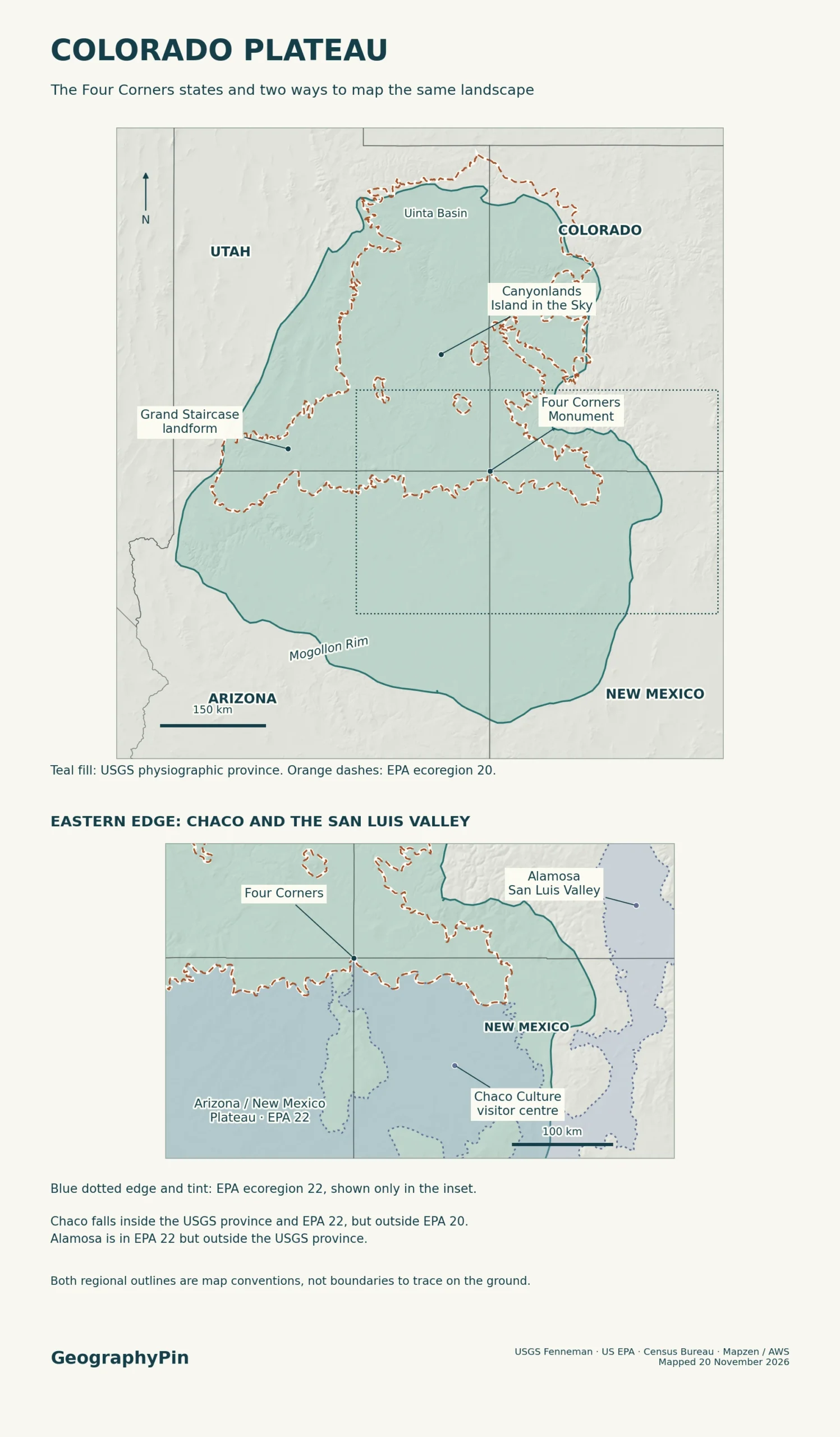
The Four Corners Monument marks the meeting of four states. “Four Corners” can also mean the surrounding area in ordinary speech, but that usage has no single mapped outer edge. The monument falls inside the plateau. Neither the dot nor the four states colored in full would show the area of the physical province.
The National Park Service’s province overview gives about 130,000 square miles (337,000 km²). That is a guide to the scale of the landform, not the area of the entire four-state region or the EPA ecoregion.
How the Grand Staircase rises northward
Across northern Arizona and southern Utah, successive cliffs and benches rise from the Grand Canyon’s North Rim toward Bryce Canyon. Geologists call this series the Grand Staircase. The steps are not a set of evenly spaced ridges. Resistant rock forms steep cliffs, while weaker rock wears back into gentler slopes and wider benches.
The White Cliffs expose pale Navajo Sandstone. The Pink Cliffs higher in the sequence include the rock sculpted into Bryce Canyon’s formations. Cliffs between them need not line up neatly on every road or appear at the same height. The steps make sense together at regional scale, even when only one part is visible from the ground.
Grand Staircase–Escalante National Monument is a managed area, not the outline of the stair-like terrain. The monument includes other landscapes, such as the Kaiparowits Plateau and the Escalante canyons, while the Pink Cliffs reach into Bryce Canyon National Park and surrounding lands.
What Canyonlands reveals about the plateau
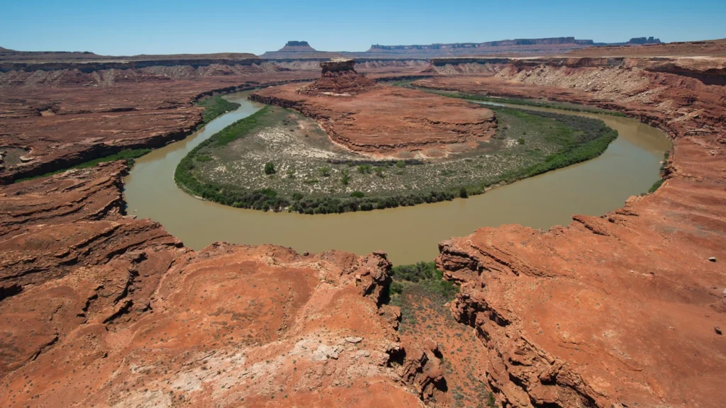
Farther northeast in Utah, Canyonlands National Park shows a different shape inside the same physical province. The Green River approaches from the northwest and joins the Colorado River inside the park. Their canyons frame Island in the Sky, a high tableland between the rivers that is still connected to land to its north by a narrow neck.
Uplift raised the region, and the rivers and their tributaries cut down through layers of sedimentary rock. The steep-walled canyons and high tops belong to the same landscape. That is why a relief map can show great local drops inside a province described as a plateau.
The national park is only part of the larger Canyon Lands section of the USGS province. A label for the park points to one protected area. A landform label covers a much wider tract of broken plateaus and valleys.
Where the plateau meets other landforms
A rim in Arizona, a transition farther west
In central Arizona, the Mogollon Rim is a recognizable edge. The Arizona Geological Survey uses the escarpment to separate the plateau to the north from the Transition Zone to the south, where faulted ranges and basins interrupt the higher tablelands. That is an example of a boundary with a visible feature on the ground.
Other edges are less tidy. Toward the Basin and Range to the west, the National Park Service describes a transition where terrain has traits of both provinces. Toward the north, the USGS places the Uinta Basin within its plateau province. The neighboring Uinta Mountains help frame that basin; the basin label is not a claim that the entire mountain range belongs to the plateau.
Toward the east, the Southern Rockies and Rio Grande Rift provide different terrain from the plateau interior. One abrupt cliff does not trace the whole province. The useful edge depends on which part of the region you are looking at and the level of detail the source map can show.
Why the USGS and EPA draw different outlines
Check the point at Chaco against both maps
The EPA’s Colorado Plateaus Level III ecoregion uses an almost identical name, but it groups places by ecosystems. Its criteria include features such as vegetation, soils, climate and land use as well as geology and landforms. Using the two published outlines and the same equal-area projection gives approximately 129,000 square miles (334,000 km²) for the USGS province and 53,000 square miles (137,000 km²) for the EPA ecoregion. These are measurements of source polygons, not legal boundaries.
| Map reference point | USGS physical province | EPA Level III ecoregion |
|---|---|---|
| Four Corners Monument | Inside Colorado Plateaus. | Colorado Plateaus (20). |
| Chaco Culture visitor center, New Mexico | Inside Colorado Plateaus. | Arizona/New Mexico Plateau (22), not Colorado Plateaus (20). |
| Alamosa area, Colorado | Outside Colorado Plateaus at the point checked. | Arizona/New Mexico Plateau (22). |
Chaco shows why the two labels cannot be swapped. Alamosa shows why adding the whole adjacent ecoregion does not recreate the physiographic province either. Each point keeps its location; the polygons answer different questions. Use the landform layer for the relief and geologic setting and the ecological layer for comparisons of environments.
Frequently Asked Questions
Is the Colorado River Basin the same as the Colorado Plateau?
No. A river basin includes land that drains to a river or its tributaries; a plateau province groups related terrain. Part of the Colorado River Basin reaches into the Southern Rockies, outside the plateau. The Colorado River crosses the plateau, but does not define its outline.
Can the plateau include mountains?
Yes. Canyonlands’ high views take in isolated ranges such as the La Sal, Henry and Abajo mountains. The National Park Service explains that resistant igneous rock became exposed as softer surrounding layers eroded. A mountain rising above a tableland does not automatically put it outside the region.
What should I use to look for the boundary on the ground?
Use the regional province map to locate the right area, then use a detailed topographic map and a geologic map to read landforms, rock units and slopes. At a visible edge such as the Mogollon Rim, contours show the slope change. In a transition zone there may be no exact step or marker to stand on.
What Did We Learn Today?
Four Corners is a state-line junction inside the Colorado Plateau, not its outer limit. The Grand Staircase and Canyonlands show different surfaces within the same physical region. Chaco helps distinguish that region from the similarly named EPA ecoregion: the first groups landforms and the second groups ecosystems.
Sources & Data Notes
The map compares the USGS physiographic polygons digitized from Fenneman and Johnson’s 1946 map with the EPA Level III polygons and their EPA classification criteria. Outline areas use the same U.S. Albers equal-area projection. Another NPS regional article cites a larger area without naming the same polygon; this comparison uses the two mapped datasets above. The point results describe those positions, not entire park boundaries. The Navajo Nation’s Four Corners Monument description, NPS province overview, Grand Staircase geologic guide, Canyonlands geologic atlas and NPS Canyonlands erosion and mountain notes establish the landmarks and terrain. See Arizona Geological Survey on the Mogollon Rim, NPS regional margin explanation, USGS Uinta Basin and plateau sections, NPS Chaco visitor center reference point and USGS Colorado River Basin description for the margins and map comparisons. Green River photograph: NPS Photo / Neal Herbert, public domain, cropped and converted to WebP. Editorial responsibility: Zurab Koniashvili (Z.K. Atlas); AI tools assisted in preparation.
Map: GeographyPin; regional geometries from the USGS physiographic shapefile and the U.S. EPA Level III ecoregions, state lines from the U.S. Census Bureau 2024 files, and relief from Mapzen/AWS. The map compares physical classifications and does not establish political or administrative boundaries.