A map of Brazil can be misleading if the Amazon is treated as the whole country. Its river lowlands, extensive highlands, seasonal wetlands and densely settled Atlantic-facing regions have different physical settings and different roles in national life.
Brazil is South America’s largest country, with Brasília as its capital. Its geography combines the Amazon basin in the north, extensive Brazilian Highlands, the Pantanal wetlands and a long Atlantic coast. Population and economic activity are unevenly distributed, with major urban concentrations in eastern and southeastern Brazil rather than throughout the Amazon interior.
How to use this article: Compare the main landscapes, separate three meanings of Amazon, or clarify Brasília’s role among Brazil’s cities.
1. Locate Brazil and read its map
Brazil occupies much of eastern and central South America. The Atlantic Ocean borders it to the east; it has no Pacific coastline. The Equator crosses northern Brazil, while the Tropic of Capricorn crosses its southern part, helping explain why the country is not contained within one climatic zone.
Its land neighbors are Uruguay, Argentina, Paraguay, Bolivia, Peru, Colombia, Venezuela, Guyana and Suriname, together with France through French Guiana. French Guiana is not an independent country. Chile and Ecuador are the two independent South American countries that do not share a land boundary with Brazil.
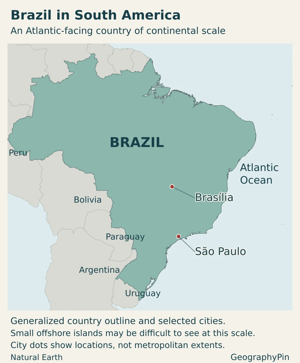
Brasília lies inland, whereas São Paulo is in the southeast. Their different positions immediately reveal an important distinction: the political capital and the largest city do not occupy the same place. For the wider continental context, see our South American countries and capitals reference.
2. Country facts with dates and definitions
| Item | Figure or description |
|---|---|
| Capital and federal government seat | Brasília, in the Federal District |
| Population | 214,211,951 residents, IBGE estimate for July 1, 2026 |
| Reported territorial area | About 3,285,483 square miles (8,509,360.850 km²), IBGE 2025 territorial framework, published March 2026 |
| Official language | Portuguese, under Article 13 of the federal constitution |
| Currency | Brazilian real (BRL; R$) |
| Political system | Federal republic with a presidential executive |
| State-level units | 26 states and the Federal District |
| Ocean frontage | Atlantic Ocean |
Why population and area carry separate dates
The population figure is an estimate for a specified date, not a new census count. Brazil’s 2022 census provides a different statistical observation, and later estimates should not be described as if they were counted on census day.
The area figure follows IBGE’s 2025 territorial framework. Updates to mapped boundaries and measurement can change a published total without implying that Brazil suddenly gained or lost an equivalent tract of land. The figure is presented as territorial area, not relabeled as a separately measured dry-land-only total. Comparisons with another country need matching land-and-water definitions as well as dates.
3. Amazon lowlands, highlands and Atlantic corridors
Brazilian relief is more varied than a simple division between rainforest and coastline. Plateaus, plains and depressions all occur. A depression in this geomorphological sense is lower than its surroundings; it does not necessarily lie below sea level.

Compare landscapes rather than assuming one uniform interior
| Area | Physical character | Geographic significance |
|---|---|---|
| Amazon lowlands | Extensive low-relief terrain, river valleys and floodplains in the north | A large drainage network links places across national boundaries; the whole basin is not one flat floodplain |
| Brazilian Highlands | A broad collection of plateaus, uplands and escarpments across much of central and eastern Brazil | Watersheds divide rivers flowing toward different drainage systems |
| Pantanal | Low-lying wetland landscape associated with the upper Paraguay River system | Seasonal water movement connects the floodplain with surrounding catchments |
| Atlantic-facing regions | Coastal plains alongside uplands and escarpments, rather than a uniformly flat strip | Major urban and transport corridors connect the coast with inland centers |
The Amazon basin and the Brazilian Highlands are not competing names for two halves of the country. A drainage basin is defined by where water flows, while a highland is a description of relief. Tributaries can rise in uplands before entering lower terrain; basin boundaries do not trace the edge of every plain.
Likewise, “Brazilian Highlands” is a broad geographic expression, not the name of one uninterrupted mountain ridge. Local plateaus, valleys and escarpments differ considerably. Brasília’s inland setting and São Paulo’s southeastern location belong to this wider upland geography rather than to the lowland Amazon landscape.
Amazon basin, Amazon biome and Legal Amazon
- Amazon basin: the area drained by the Amazon River and its tributaries. It extends beyond Brazil.
- Amazon biome: an ecological region defined through its environmental and biological characteristics, not simply the direction of river flow.
- Legal Amazon: a Brazilian area established through legislation for regional planning and policy. Its boundary is not identical to either the biome or the international river basin.
Brazil’s six officially mapped terrestrial biomes are the Amazon, Cerrado, Caatinga, Atlantic Forest (Mata Atlântica), Pampa and Pantanal. These ecological categories add another layer to the physical map: a biome is not simply a plateau, a state or a river basin.
These distinctions matter when reading a percentage, a conservation claim or a map. A figure for the Legal Amazon cannot automatically be applied to rainforest coverage, and a Brazilian water-management region is not necessarily the entire international basin. Our Amazon River basin map examines the drainage system in more detail.
4. Climate, rivers and environmental contrasts
Rainfall patterns matter as much as latitude
Much of northern Brazil is hot and humid, while large parts of the tropical interior have stronger seasonal differences in rainfall. The semiarid interior of the Northeast contrasts with wetter coastal and northern regions. Southern Brazil has a cooler seasonal character, and elevation introduces additional local differences.
That pattern rules out two common shortcuts: Brazil is not all equatorial rainforest, and its Northeast is not uniformly dry. Climate classifications describe broad patterns; conditions can change within a state as relief, distance from the coast and atmospheric circulation vary.
The Amazon and Paraguay systems do different jobs
Brazil’s Amazon hydrographic region includes major rivers such as the Amazonas, Solimões, Negro, Madeira and Xingu. Their connected network illustrates why rivers are central to understanding the northern landscape. The region’s abundant surface water is not evenly matched to the country’s distribution of population and demand.
The Pantanal belongs to a different drainage setting: the Paraguay system in west-central South America. In Brazil, this region includes parts of Mato Grosso and Mato Grosso do Sul. Erosion and sediment movement in the wider catchment can affect the wetland downstream, so its condition cannot be understood by looking only at water visible on the floodplain.
Farther south, the Paraná River and the Paraguay River belong to the wider Río de la Plata drainage system, along with the Uruguay. They are connected within that larger system, separate from the Amazon, rather than being unrelated rivers that each drain independently to the ocean.
Water abundance also does not remove environmental risk. Flooding, drought, erosion and water pollution have different causes and locations. Broad regional labels provide context, but current local conditions require their own evidence rather than a countrywide assumption.
5. People, cities and languages
Brazil is a highly urbanized country. In the 2022 census classification, 87.4% of residents lived in urban areas. That is a dated description of where people lived, not a claim that 87.4% of the national territory was built up.
The Atlantic-facing concentration is substantial but not exclusive. An IBGE analysis of preliminary 2022 census sectors found more than half the population in sectors wholly within roughly 93 miles (150 km) of the coast. Inland capitals, agricultural centers and Amazonian cities remain important parts of the national urban system.
Brasília is the capital; São Paulo is the largest city
Brasília became the federal capital in 1960. Its inland location makes it a particularly clear example of the difference between political geography and the historic coastal pattern of settlement. Rio de Janeiro was the preceding capital, but it is not the present federal government seat.
São Paulo is the country’s largest city by municipal population. A municipality, its continuously built-up urban area and its wider metropolitan region are different geographic units, so figures for them should not be interchanged. Our major cities in Brazil article covers the city network without requiring the country profile to reproduce a full ranking.
An official language does not mean only one language
Portuguese is Brazil’s official language. The constitution also recognizes Indigenous peoples’ languages, customs and traditions, and provides for the use of their mother tongues in Indigenous primary education. The official-language label should therefore not be read as a claim that every Brazilian community has the same linguistic background.
6. Government and economy in their geographic setting
States, the Federal District and municipalities
Brazil’s federal system combines national institutions with states, the Federal District and municipalities. The president leads the federal executive; the National Congress consists of the Chamber of Deputies and the Federal Senate. Brasília is the federal capital under the constitution, not merely an informal administrative center.
The Federal District has a different legal position from an ordinary state or municipality: the constitution prohibits its division into municipalities. This is one reason statistical references to Brasília need careful attention to geographic coverage rather than an assumption that all capital-city boundaries work alike.
Services, industry and agriculture have different centers
São Paulo state illustrates Brazil’s large urban economy. Its economic structure includes substantial manufacturing, but commerce and services account for the larger share in the state’s 2023 economic data. Describing Brazil only through rainforest resources or farm exports leaves out this major dimension of national activity.
Mato Grosso provides a contrasting agricultural example. Embrapa’s soybean summary, using CONAB’s May 2026 crop survey, identifies it as Brazil’s largest soybean-producing state. This is a specific crop-and-date statement, not a ranking of every type of agriculture or a claim that the whole state is farmland.
Transport links connect these different economic landscapes to markets and ports. Distance alone does not explain the pattern: infrastructure, urban networks and production systems also matter. Brazil’s geography is most useful when it connects these regions rather than reducing the country to one industry or one biome.
Frequently Asked Questions
Does all of Brazil use Brasília time?
No. Brazil has four standard time zones, from UTC−2 to UTC−5, including its oceanic islands. Brasília uses UTC−3. A national event advertised in Brasília time may therefore occur at a different local clock time elsewhere in the country.
Are Brazil’s five official regions the same as its physical regions?
No. The North, Northeast, Center-West, Southeast and South group states and the Federal District for regional organization and statistics. Physical regions describe landforms; biomes describe ecological patterns; river basins describe drainage. Their boundaries need not coincide.
What Did We Learn Today?
Brazil’s large scale becomes easier to understand when drainage, relief and settlement are read separately and then connected. The Amazon basin is not identical to either the Amazon biome or Legal Amazon; the highlands and Pantanal have distinct physical roles; and a highly urban population does not mean a uniformly urban landscape. Brasília’s political role and São Paulo’s urban scale illustrate why geographic definitions matter.
Sources & Data Notes
Population is IBGE’s July 1, 2026 resident estimate. Territorial area uses the 2025 framework published in March 2026; it is not presented as a separate dry-land measure. Urbanization refers to the 2022 census. The coastal concentration example comes from the preliminary census-sector release and counts sectors wholly within the coastal band. Economic references retain their individual dates. Unit conversions are rounded. Basin, biome and administrative boundaries are not interchangeable.
- Observatório Nacional: Brazil’s time zones
- IBGE Educa: biomes and their environmental contrasts
- IBGE: five major regional groupings
- Ministry of Planning: Brazil’s neighboring countries and French Guiana
- IBGE: 2026 population estimate
- IBGE: territorial areas and 2025 measurement
- IBGE Educa: Brazilian relief
- IBGE: Legal Amazon definition
- IBGE Educa: climate
- ANA: Amazon hydrographic region
- ANA: Paraná, Paraguay and Uruguay within the Plata basin
- ANA: Paraguay hydrographic region
- IBGE Educa: 2022 census urban population
- IBGE, republished by Agência Gov: census-sector geography and coastal population
- Federal Constitution: official language, capital and government organization
- Brazilian government: Brasília’s capital and government-seat functions
- MDIC: São Paulo state economy, 2023 sectoral data
- Embrapa: soybean data, citing CONAB May 2026 survey
- Central Bank of Brazil: Brazilian currency
Maps and illustration: Original GeographyPin cartography uses public-domain Natural Earth country outlines, populated places and river lines with its shaded-relief raster. Layers are reprojected into a Brazil-centered equal-area map. City markers represent locations, not metropolitan footprints. Generalized coastal and offshore islands are retained, although the smallest are difficult to see at this scale.
The physical map labels broad landscapes rather than drawing measured regional boundaries. The selected Amazon River segments do not show every tributary or mouth channel and do not define the basin. Neither the river line nor the Amazon lowlands label represents the Amazon biome or Legal Amazon. Relief shading shows terrain form, not numeric elevation bands. The featured illustration clips a public-domain Brazilian flag vector into the country outline as a decorative motif, not a complete rectangular flag.