Abidjan’s skyline tells only part of its story. The Ébrié Lagoon, older shoreline communities, port facilities and a wide ring of urban districts all shape Côte d’Ivoire’s largest city. Its economic importance also explains why it is often confused with the country’s political capital, Yamoussoukro.
Abidjan’s location and urban role
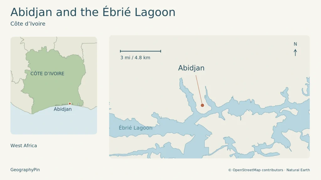
Abidjan is Côte d’Ivoire’s largest city and economic capital, on the Ébrié Lagoon near the Gulf of Guinea. Yamoussoukro is the political and administrative capital. The ten-commune city and the wider Autonomous District of Abidjan have different boundaries and census totals, so their population figures are not interchangeable.
Find your starting point: Explore the lagoon setting, distinguish city and district, or clarify the capital functions.
1. A lagoon city on Côte d’Ivoire’s southern coast
Water separates and connects the city
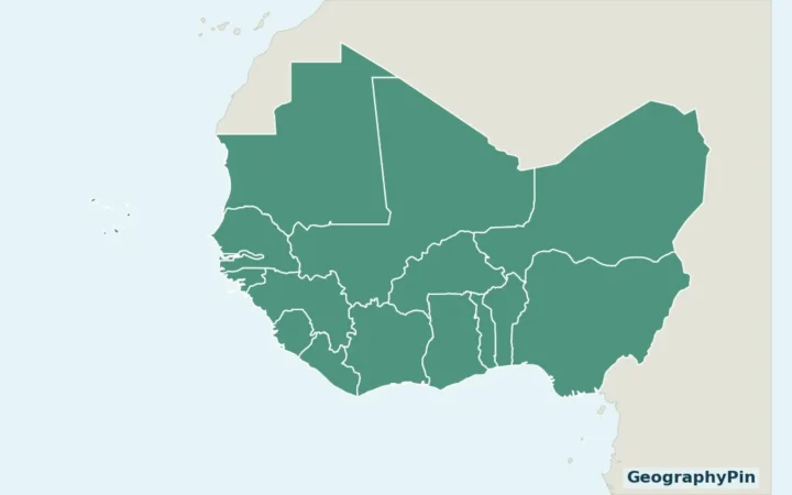
Abidjan is in southern Côte d’Ivoire, in West Africa, beside the Ébrié Lagoon and the Atlantic coast of the Gulf of Guinea. The lagoon is not simply a scenic edge to the city. It divides neighborhoods, creates waterfronts and channels movement between residential areas and workplaces.
Cocody and its Riviera and Deux-Plateaux neighborhoods occupy the northern side of this urban lagoon landscape. The port and airport lie to the south. The African Development Bank’s account of the Henri Konan Bédié Bridge explains why crossings matter: areas close together across the water can have much longer connections by road.
The HKB Bridge opened in December 2014, adding a crossing between the Cocody and Marcory sides of the city. It changed the available connections rather than removing the lagoon’s influence. The water and its crossings remain essential to understanding the city’s layout.
The coastal setting also links the city to maritime trade. The Vridi Canal connects the lagoon with the Atlantic, allowing the port to operate within the lagoon system. This relationship between inland water and open sea is central to Abidjan’s development.
The locator above shows the lagoon setting, not the boundaries of the ten-commune city or autonomous district. Enlarge map.
2. City, autonomous district and population
Two official population totals, two different extents
The 2021 census groups ten communes as the “Ville d’Abidjan”: Abobo, Adjamé, Attécoubé, Cocody, Koumassi, Marcory, Plateau, Port-Bouët, Treichville and Yopougon. A commune is a local government area, not merely an informal neighborhood.
The wider Autonomous District of Abidjan includes the core city and peripheral areas. In the same census table, Anyama, Bingerville, Brofodoumé and Songon appear separately below the city total, before the district total. That is why two different population figures can both be correct.
| Named extent | Population |
|---|---|
| Abidjan city: ten-commune total | 5,616,633 |
| Autonomous District of Abidjan: wider total | 6,321,017 |
These are dated census figures, not estimates of today’s population or a separately defined metropolitan commuting area. The larger figure should not be attached to a map of only the ten core communes.
Under the district’s 2014 statute, its territory corresponds to the department of Abidjan and brings together communes and subprefectures. The district is a special territorial entity with its own legal personality and financial autonomy. Its responsibilities include development, environmental protection and territorial planning. It is not another name for the continuously built-up area.
3. Why Yamoussoukro is the capital
Political capital and economic center
Yamoussoukro became Côte d’Ivoire’s political and administrative capital on March 21, 1983. Abidjan remains the country’s economic capital and largest city. Those descriptions refer to different functions; calling Abidjan the economic capital does not make it the national political capital.
The distinction is visible in the country’s geography. Yamoussoukro is inland, while Abidjan’s port, airport, financial activity and international connections are concentrated around the southern metropolis. A national capital map should mark Yamoussoukro correctly, while an account of the country’s commercial life must give Abidjan substantial attention.
4. Lagoon communities, colonial expansion and the port
The city did not begin on empty land. The district authority’s history identifies Tchaman communities, also widely called Ébrié, around the lagoon before colonial urban development. Bidjan settlements formed part of that local history.
French colonial development reshaped the Plateau. The district’s account records the displacement of local residents and destruction of their homes as the commercial and administrative quarter expanded in the early twentieth century.
Abidjan’s designation as colonial capital followed a 1933 decree, with the transfer taking effect in 1934. The opening of the Vridi Canal in 1950 and the port in 1951 then strengthened its commercial position.
5. Work, international institutions and cultural life
The African Development Bank Group is headquartered in Abidjan. Its work financing development across African countries gives a concrete example of the city’s international institutional role, rather than treating “economic capital” as only a promotional label.
Cultural activity provides another connection beyond the city. The Marché des Arts du Spectacle d’Abidjan, known as MASA, brings performing arts into that international exchange. The Ministry of Culture records the opening of its fourteenth edition on April 11, 2026, at the Palais de la Culture Bernard Binlin Dadié in Treichville.
That dated event illustrates Abidjan’s cultural role; it is not an announcement of a future festival. The city’s identity includes the work of artists and cultural institutions as well as offices, industrial facilities and transport infrastructure.
The Presidency also describes a cosmopolitan population with substantial communities from other West African countries. Alongside the older lagoon communities, these regional connections are part of the city’s social history. They should not be reduced to a single language, neighborhood or uniform “urban lifestyle.”
6. Banco forest within the metropolis
Abidjan is not entirely a landscape of buildings and paved streets. Banco National Park lies among Adjamé, Attécoubé, Abobo and Yopougon. The Ivorian Office of Parks and Reserves describes it as both a biodiversity reserve and a place important to the city’s groundwater protection.
The park authority lists an area of approximately 8,496 acres (3,438 hectares), including surviving primary forest. Its presence places a substantial protected green area beside densely developed parts of the metropolis. Forest, lagoon and urban neighborhoods are closely juxtaposed rather than confined to separate distant regions.
That combination is a useful final way to understand Abidjan: a large coastal city whose shape still depends on water, vegetation and the connections built between its districts. For sightseeing choices, arrival logistics and access checks, use the separate Abidjan travel guide.
What Did We Learn Today?
Abidjan is a lagoon city, a commercial center and a collection of distinct urban areas. Its history connects local communities, colonial planning and port development. Separating the core city from the autonomous district, and economic prominence from political capital status, makes both its map and its population easier to understand.
Sources & Data Notes
Open sources and data notes
Research checked November 18, 2026. Population uses the published city and autonomous-district totals from the final 2021 census, not a current projection. Census categories are not a delineation of continuous built-up land. The Presidency’s undated population shorthand is not used. Bridge history does not establish current journey times. Banco’s area is rounded from the park authority’s 3,438.34 hectares; its inconsistent day-and-month founding dates are omitted. The MASA reference concerns a past event, not a future schedule.
- Government-hosted final 2021 census tables, page 1
- Abidjan district: 2014 statute, Articles 1–4
- Presidency: Abidjan’s location and economic role
- Presidency: Yamoussoukro’s capital status
- Abidjan district: local communities and urban history
- African Development Bank: lagoon setting and HKB Bridge, 2015 account
- African Development Bank: institutional role and headquarters
- Culture Ministry: MASA opening, April 12, 2026 report
- Ivorian Office of Parks and Reserves: Banco National Park
Map: original GeographyPin cartography using © OpenStreetMap contributors, ODbL (Ébrié Lagoon shoreline, relation 1982728, version 102), and public-domain Natural Earth outlines and generalized city point. Checked November 18, 2026. The locator is not an administrative boundary, built-up extent or transport map; scale applies only to the local lagoon panel.