Cyprus sits just off the mainland coast of the eastern Mediterranean. An archaeologist writing about the prehistoric Levant included it; a World Bank study called A New Levant did not put it among its seven core economies. Comparing the two maps shows why asking where the Levant ends is really asking what the map is for.
A common modern core includes Syria, Lebanon, Jordan, Israel and the State of Palestine. The Levant has no official modern boundary. Archaeological usage can include Cyprus, Egypt’s Sinai Peninsula and parts of southern Türkiye. The World Bank’s 2014 “New Levant” report used a different scope for a trade study, extending to Iraq.
How to use this article: Compare the two maps, use three places near the margins to test what each includes, and check the UN statistical grouping before using any of these definitions as a country list.
The core along the eastern Mediterranean
Compare the two documented map frames
The Levant is centered on the Mediterranean’s eastern shore and its neighboring inland areas. The coast is a useful reference, but it is not a test that every place has to pass. Jordan, for example, is part of the common Levant core even though it has no Mediterranean coastline. Our Middle East country guide uses this five-entry core as one part of a much larger region.
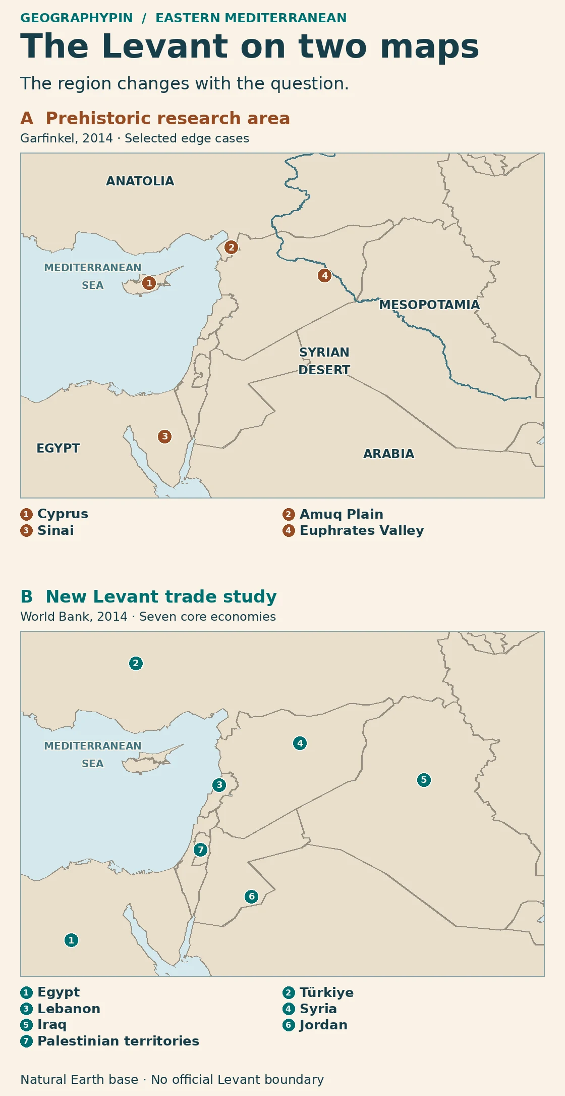
The two panels use the same present-day basemap. Panel A locates features in archaeologist Yosef Garfinkel’s study of the Pottery Neolithic and Chalcolithic periods. Panel B locates the seven economies in the World Bank’s March 2014 “New Levant” study. Neither set of markers traces a historical state or a modern regional boundary.
Reading key: The common modern core used here is Syria, Lebanon, Jordan, Israel and the State of Palestine. That list is a geographic convention, separate from both mapped examples. Panel A uses “southeastern Türkiye” for the Amuq Plain in Hatay, not the whole of southeastern Türkiye. Panel B includes Türkiye as an economy, not as a proposed Levant boundary.
Cyprus, the Amuq Plain and Sinai
Cyprus, Sinai and Iraq in the two frames
Garfinkel’s prehistoric study reaches across the sea to Cyprus. It also names two mainland areas that are smaller than their modern countries: the Amuq Plain in southern Türkiye and the Sinai Peninsula in Egypt. It specifies western Syria rather than using all of modern Syria as a single study area.
Take Tell Atchana, the site of ancient Alalakh in the Amuq Plain. It is in the northern margin of the archaeological frame. The trade report also includes it in a broad sense, but for a completely different reason: the site is in Türkiye, one of the study’s core economies. The archaeological inclusion tells you where a site sits in a landscape; the economic inclusion tells you which national data the study considered.
Cyprus is the reverse example. An island can be included in a study of prehistoric connections without being one of the economies selected for a trade report. Sinai illustrates the distinction within Egypt: Garfinkel names the peninsula, whereas the World Bank includes the Egyptian economy. Coloring all of Egypt to represent both would erase the difference.
Where the inland margin moves
Garfinkel uses the Euphrates Valley to separate his study area from Mesopotamia. The thin blue line in Panel A shows the modern river for orientation. The valley is broader than that line, and the map does not use the channel as a legal boundary or claim that the same line applies to every period.
The trade study extends farther inland because it starts with a different question: what could closer economic ties among its selected economies offer? Its seven core entries are Egypt, Iraq, Jordan, Lebanon, Syria, Türkiye and the Palestinian territories, using the report’s terminology for the last entry. Iraq is inside that economic comparison even though Garfinkel treats the Euphrates as a reference for separating the Levant from Mesopotamia. Israel is outside the report’s core seven but appears in some of its wider sector comparisons. That is not a claim about Israel’s geographic location.
Which source draws the boundary?
What the UN Western Asia group counts
The UN Statistics Division’s M49 system has a category for Western Asia but none named the Levant. In that table, Cyprus, Iraq and Türkiye are in Western Asia, while Egypt is in Northern Africa. That works for compiling data consistently across countries and areas. It does not resolve whether to include a particular island, peninsula or valley in a historical study.
| Place | Prehistoric study frame | Trade report’s core group |
|---|---|---|
| Cyprus | Included | Not listed in the core seven |
| Amuq Plain | Included as a specific part of southern Türkiye | Inside the larger economy of Türkiye |
| Sinai | Included as a peninsula | Inside the larger economy of Egypt |
| Iraq | Not listed in the study area; Euphrates Valley is the reference on the Mesopotamian side | Included as a core economy |
Frequently Asked Questions
Does the Levant have an official modern border?
No. Modern countries have their own boundaries, but no single boundary applies to the Levant as a region. The UN M49 table does not define a Levant subregion.
Are the Levant and the eastern Mediterranean the same?
No. An eastern Mediterranean map can show the sea and all its surroundings. A Levant map is normally concerned with part of that area, especially its eastern shore and adjacent inland places.
Can the same site be described as Anatolian and Levantine?
Yes, under different frames. Tell Atchana is in southern Türkiye, and archaeological research also places its Amuq Plain setting in the northern Levant. One label describes its position in present-day geography; the other describes the regional context of a study.
What Did We Learn Today?
The eastern Mediterranean is the anchor, not a fixed perimeter. Start with the common core, then read the map’s definition before deciding whether islands such as Cyprus, places inland near the Euphrates, or whole economies such as Egypt belong in the same comparison.
Sources & Data Notes
View sources and map notes
- Yosef Garfinkel, The Levant in the Pottery Neolithic and Chalcolithic Periods, Cambridge University Press, 2014. Author-defined geographical scope in the opening summary.
- Tell Atchana (Alalakh) excavation report, University of Chicago Press distribution listing. Excavators locate the site in Hatay’s Amuq Valley.
- World Bank, Over the Horizon: A New Levant, March 2014. Executive summary and introduction, including the seven core economies and wider comparisons. The Palestinian territories locator is in the West Bank; the dot does not delineate the full area covered by the term.
- UN Statistics Division, M49 overview, Western Asia and Northern Africa.
- GeographyPin maps use public-domain Natural Earth 1:10 million land and river geometry for present-day orientation. Locators are representative; no historical region polygon, status claim or survey boundary is drawn.
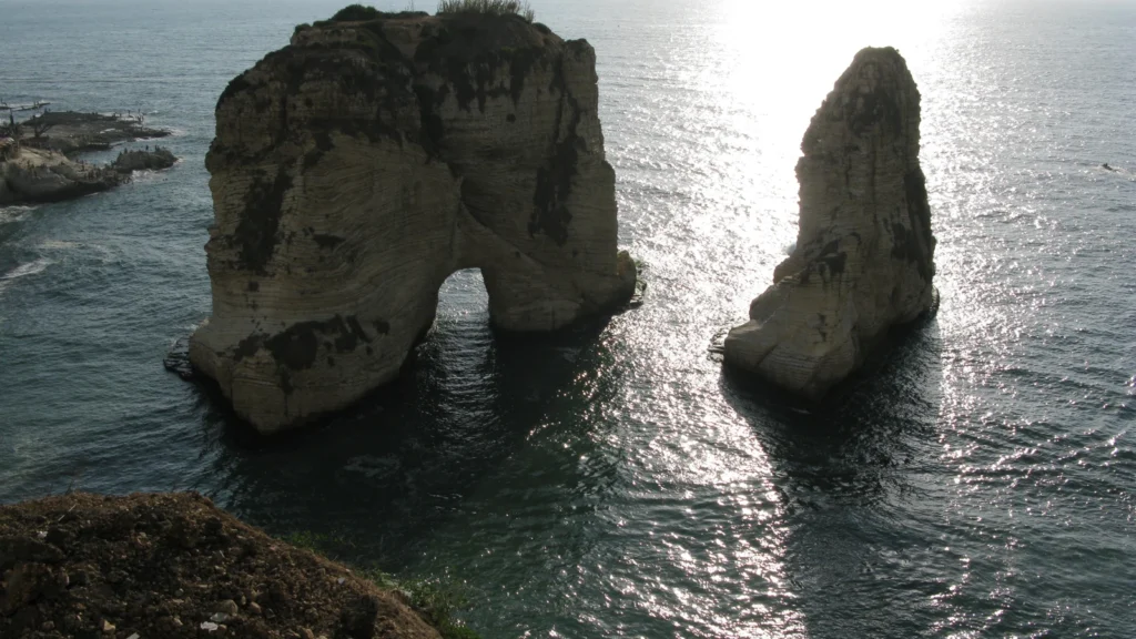
- Featured photograph: Vyacheslav Argenberg, Raouché Rocks and Corniche Beirut, CC BY 4.0, cropped.
