Follow the Alabama River through Selma and you are in the historical Black Belt. Look at a map of the prairie, though, and the town sits near its edge. The name follows both a band of dark soil and a much wider history of agriculture, settlement and civil rights.
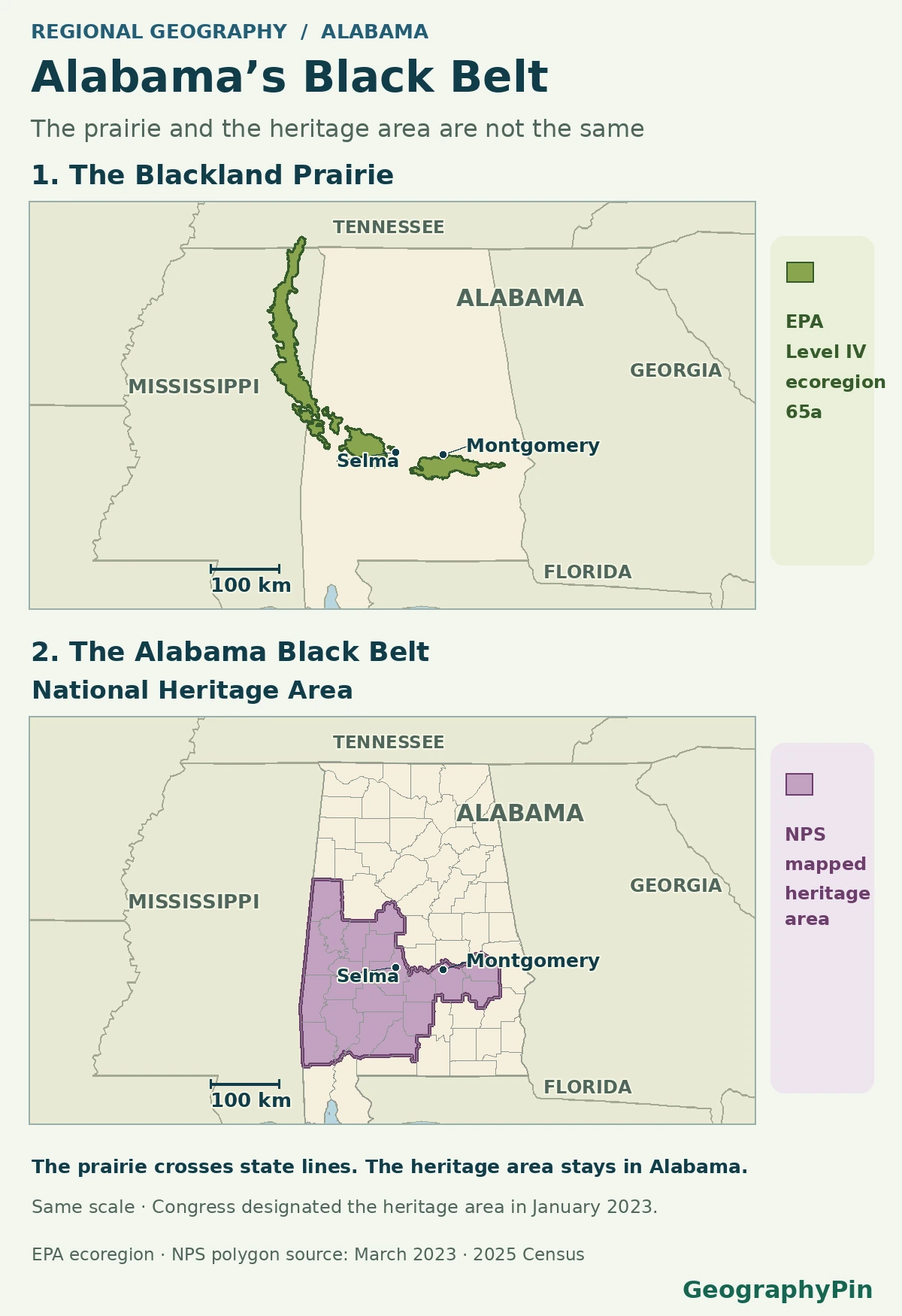
Alabama’s Black Belt takes its name in part from a band of dark prairie soils across central Alabama. It also names a broader historical region shaped by cotton plantations, slavery and African American communities. The mapped Blackland Prairie and the Alabama Black Belt National Heritage Area overlap, but they do not share one boundary.
How to use this article: Start with where the prairie is drawn, check why the name expanded, see what the 2023 designation covers, or check the Selma–Montgomery example.
Where the dark prairie runs
The line on the EPA map follows an ecoregion
The U.S. Environmental Protection Agency’s Level IV map labels a long, narrow ecoregion Blackland Prairie (65a). It curves through eastern Mississippi into central Alabama and reaches slightly into Tennessee. The shape follows regional patterns in land, soils and ecology. It does not stop at each county line, and it does not mean every field inside it has one soil type.
The USDA land-resource handbook describes chalk, marl and related sedimentary material beneath many of the Blackland Prairie soils. Where local conditions favor it, weathering produces clay-rich, often dark surface soils. The region can include shallower chalky ground as well as deeper soils. A soil series or a field-scale survey answers a narrower question than either of the maps here.
Why the soil name became a regional name
Cotton connected farms, towns and labor beyond the soil band
In 1911, soil researchers Hugh H. Bennett and Matt A. Cosby’s published study of prairie soils described dark clay soils already used for cotton, corn and other crops. The connection between cotton and the soil helps explain the name, but does not explain the region’s society by itself. The plantation economy depended on enslaved Black labor. Towns, markets and routes linked agricultural land to places outside the narrow prairie.
Dallas County gives that history a place and a scale. The 1880 U.S. census cotton report records 33,534 bales and 115,631 acres planted in cotton, about 56% of the county’s reported tilled land. It also describes cotton growing well on light-colored sandy terraces along the Alabama River. Cotton was not confined to the dark prairie soils shown on the map.
Land and labor tell different parts of the story. In the 1860 U.S. census, 25,760 of Dallas County’s 33,625 residents were enslaved. After emancipation, the Selma Freedmen’s Bureau office records include an 1865 register of employment terms and 1866–1869 labor contracts. The cotton total does not tell us who worked each farm or on what terms.
The National Park Service’s account of the heritage area uses Black Belt in both senses: the dark-soil strip and a history of slavery, African American communities and the civil rights movement. The broader historical name is not a claim about current population percentages, vegetation or land use in every county. Many of the processes that shaped the region did not end where the chalk beds did.
| Term | Boundary or source | What it helps explain |
|---|---|---|
| Blackland Prairie | EPA Level IV ecoregion 65a | Land and ecological patterns across state lines |
| Alabama Black Belt National Heritage Area | National Park Service’s mapped perimeter | Cultural heritage cooperation within Alabama |
| Historical cotton country | A descriptive economic and historical term | Evidence from farms, labor, trade and settlement |
What the heritage-area map counts
The federal designation was made in January 2023
Congress established the Alabama Black Belt National Heritage Area on January 5, 2023, through Public Law 117-339, which refers to a specific September 2021 map. The University of West Alabama, the local coordinating organization, describes a 19-county area. The lower map uses the National Park Service’s mapped perimeter, not a recreated legal survey sheet.
Start near Selma and look east toward Montgomery. Both are inside the mapped heritage area, but their central city markers sit outside the EPA’s narrow 65a ecoregion. Parts of the adjacent country are prairie. That difference does not contradict their strong historical connection to the Black Belt. It shows why assigning the same region label to the whole county can change the answer.
Selma and Montgomery show why the wider region matters
A historic route crosses different landscapes
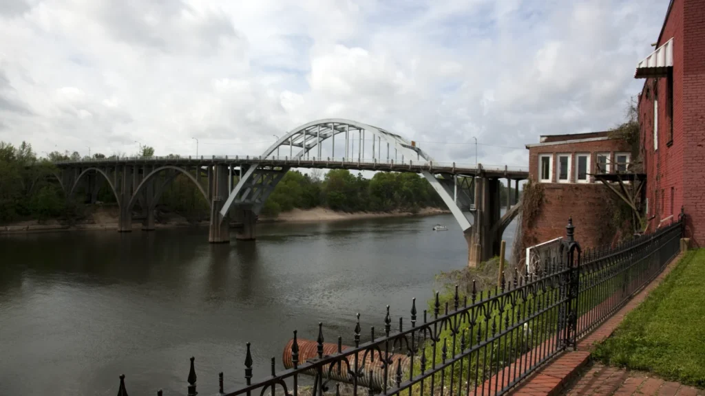
The Selma to Montgomery National Historic Trail follows the 54-mile (87-kilometer) route of the 1965 voting rights march. It links Selma, Lowndes County and the state capital. On March 7, nonviolent marchers were stopped violently on the Edmund Pettus Bridge. A subsequent march began March 21 and reached Montgomery on March 25.
A prairie map helps explain where particular soils and plant communities occur. It cannot show why the movement took this route or why these towns belong together in a heritage area. Use the historical boundary for the history, the EPA layer for regional ecology, and a local soil map when the question is about a particular tract.
Frequently Asked Questions
Is every Black Belt county on black prairie soil?
No. Counties can contain several soil types and cross more than one ecoregion. For a specific field or settlement, consult a local soil survey rather than the county name.
Is the Blackland Prairie in Alabama the same as the Texas Blackland Prairies?
No. The two regions share a descriptive name for dark prairie landscapes, but they are geographically separate. An Alabama map does not cover the Texas region.
Does National Heritage Area status make the land a national park?
No. A National Heritage Area recognizes a landscape and supports local partnerships. Its designation does not turn all land inside the boundary into federally owned parkland.
What Did We Learn Today?
The Blackland Prairie is a physical region that crosses state lines. Alabama’s Black Belt also includes a wider area connected by plantation history, settlement and the civil rights movement. A map of one boundary cannot substitute for a map of the other.
Sources & Data Notes
The U.S. EPA Level IV ecoregion and the National Park Service mapped perimeter supply the two boundaries. USDA sources describe local materials and agricultural history. Public Law 117-339 and the local coordinating university explain designation and coverage. The National Park Service trail history identifies the people, dates and route. The comparison is geographic, not a property or soil survey.
Featured image: The Edmund Pettus Bridge, Selma, Alabama, Carol M. Highsmith, April 7, 2010, George F. Landegger Collection of Alabama Photographs in Carol M. Highsmith’s America, Library of Congress Prints and Photographs Division. [Highsmith Archive rights information](https://www.loc.gov/pictures/collection/highsm/access.html): photographer dedicated this archive image to the public domain; no known restrictions. Cropped, resized and converted to WebP. Commons record. Map geometry: EPA Level IV ecoregions, the NPS heritage-area layer, and U.S. Census general reference boundaries. The NPS layer is an agency geographic depiction, not the survey- or legal-scale designated sheet.