Torres Strait separates mainland Australia from New Guinea, but its islands make a halfway line a poor guide to the border. Some Australian islands lie only a few miles from Papua New Guinea’s shoreline.
Torres Strait lies between Cape York Peninsula in Australia and the southern coast of Papua New Guinea. It connects the Arafura Sea in the west to the Coral Sea in the east. Its islands include Saibai and Boigu, which belong to Australia even though they sit close to Papua New Guinea.
How to use this article: Compare the two distance scales, locate the inner islands near Cape York, then read the separate treaty lines and find the central cays and islands.
Torres Strait’s location and water connections
The strait lies between Australia’s Cape York Peninsula and the south coast of Papua New Guinea, on the island of New Guinea. The Arafura Sea and the approach to the Gulf of Carpentaria lie west of it; the Coral Sea lies to the east. An archipelago fills the space between the mainlands.
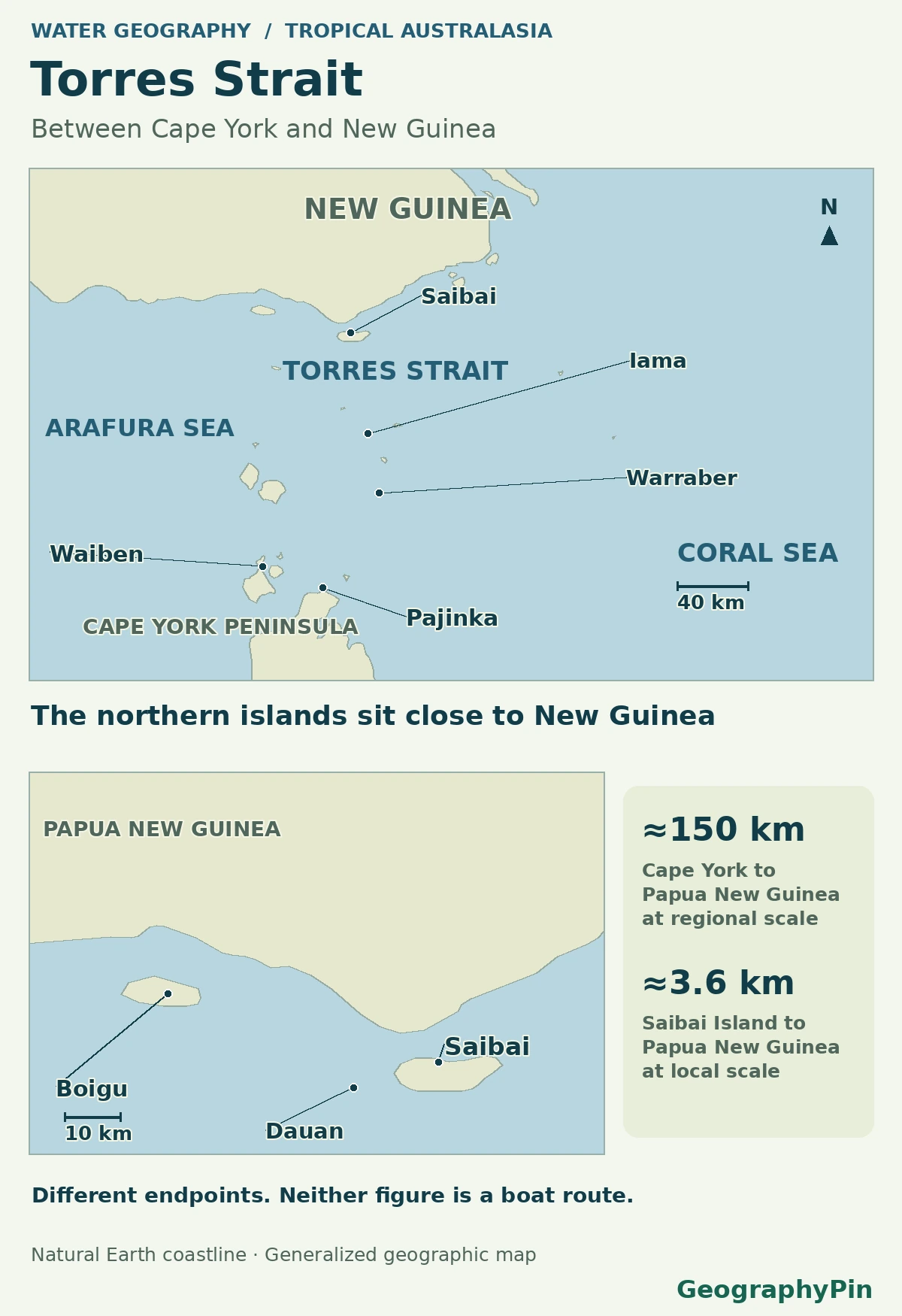
Compare the mainland span and the Saibai gap
The Torres Strait Regional Authority describes an approximately 93-mile (150 km) north–south span from Cape York Peninsula to Papua New Guinea. Australia’s agriculture department gives about 2.2 miles (3.6 km) from Saibai Island to Papua New Guinea. The first number describes the strait’s mainland setting; the second is a local gap from a particular Australian island, not the mainland crossing.
Cape York and the inner islands
Find Pajinka, Waiben and Endeavour Strait
At the southern edge, Pajinka is the tip of Cape York Peninsula and the northernmost point of mainland Australia. North of the peninsula are the inner islands, including Waiben (Thursday Island), Ngurupai (Horn Island) and Muralug (Prince of Wales Island). The Torres Strait Regional Authority identifies the Endeavour Strait between the mainland and Muralug; this local passage is only one part of Torres Strait.
Waiben is in the inner group, not in the middle of a straight line from Cape York to Papua New Guinea. Using a regional locator alongside the island labels prevents that mistake.
Papua New Guinea’s coast and the treaty lines
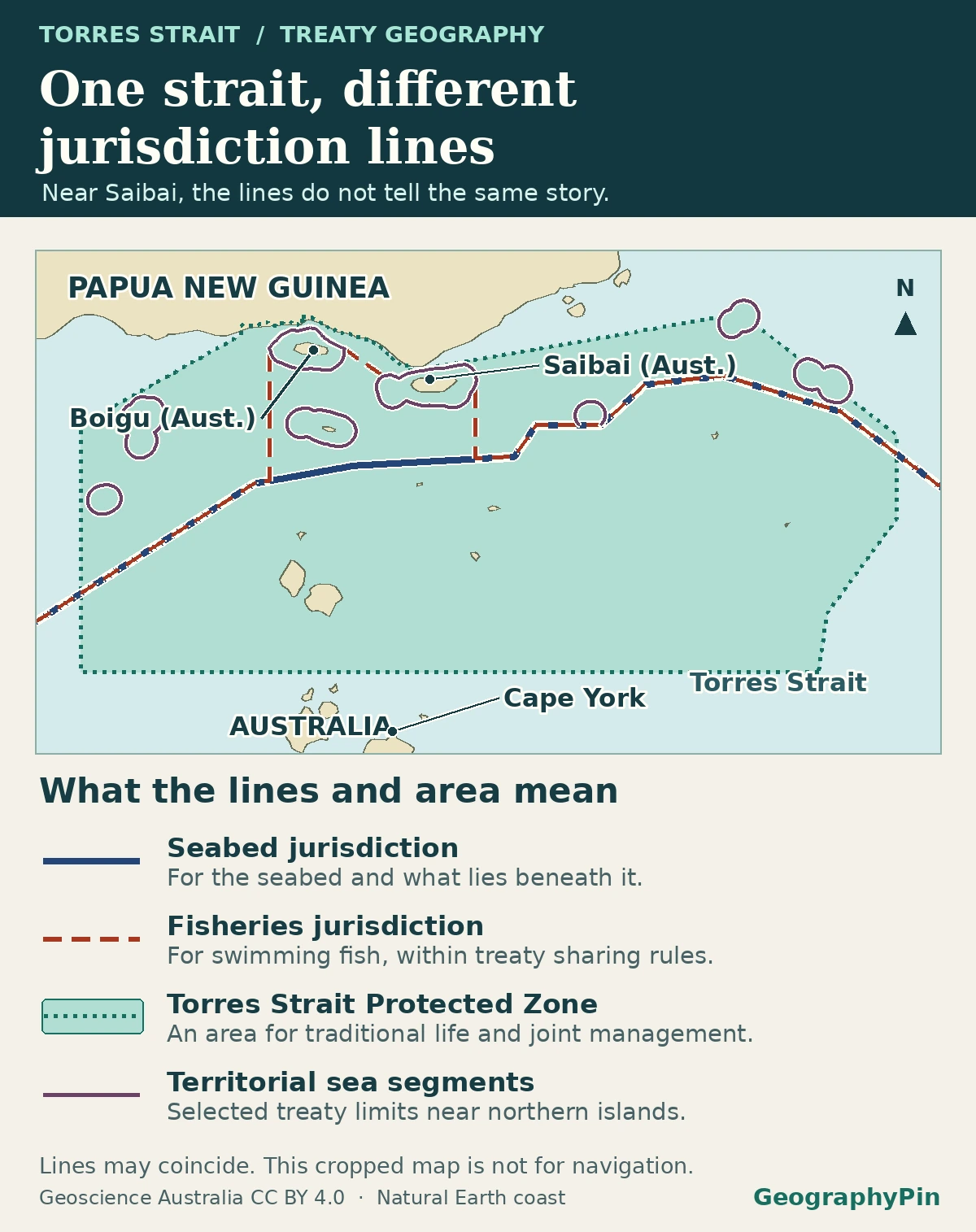
Read the seabed, fisheries and island limits separately
At the northern edge, Saibai, Boigu and Dauan are Australian islands near Papua New Guinea’s Western Province. The Torres Strait Treaty places them on the Papua New Guinea side of the Seabed Jurisdiction Line while explicitly retaining Australian sovereignty over the islands. Their territorial-sea limits are addressed separately, so a line can bend around island waters rather than run through them or follow a simple halfway line.
The Fisheries Jurisdiction Line serves a different purpose: under the treaty it separates the two countries’ fisheries jurisdictions, alongside arrangements for sharing fisheries. The Torres Strait Protected Zone is an area, not a border. It supports traditional activities of qualifying Torres Strait Islander and Papua New Guinean coastal communities and helps protect the marine environment. Those distinct roles are why the map should not label every dashed line “international boundary.”
The central islands: reefs, cays and rocky islands
Recognize Poruma and the central island group
Iama (Yam Island), Masig (Yorke Island), Poruma (Coconut Island) and Warraber (Sue Island) belong to the Central Group in the regional council’s classification. Masig, Poruma and Warraber are low coral cays built on reef platforms. Iama is an island with a rock base. A map of land outlines can make their differences look smaller than they are.
The inhabited islands are places with their own names and communities, not just markers on the way to New Guinea. The Gab Titui Cultural Centre and the regional council use Indigenous names, often paired with the English names carried on older map series.
What changes with tide, season and map scale
A coastline outlines land; a bathymetric chart describes the seabed below the water. The latter can distinguish shallow reef platforms from channels that appear as one unbroken blue area on a small locator. It is still a survey-based representation. Changing tides alter water level above that bottom, while a coarse grid can omit smaller features.
At Poruma, a regional adaptation report illustrates the tip of the cay shifting as seasonal winds and currents move sediment. Even an accurate outline captures a particular observation or dataset. Its scale or date matters especially when comparing low cays and reefs rather than the location of a large island.
Frequently Asked Questions
What does Zenedth Kes refer to?
It is a name used by the Torres Strait Island Regional Council for Torres Strait. It refers to the broader region, not just Thursday Island or one central island cluster.
Do the numbers count all islands or only places with communities?
Check what each source counts. The Torres Strait Regional Authority identifies 17 inhabited islands that its programs cover, plus communities on the Australian mainland. That is a service-area statement, not a count of every island, cay or exposed rock.
What is the Torres Strait region’s main administrative center?
Waiben (Thursday Island) is the administrative center, despite being in the inner island group rather than at the geographic middle of the strait.
What Did We Learn Today?
The Strait’s mainland span is far wider than the gap between Saibai and Papua New Guinea. Its island geography is also why the Seabed Jurisdiction Line, fishery arrangements and island territorial waters need different map symbols rather than one simple boundary.
Sources & Data Notes
The Torres Strait Regional Authority locator supplies the regional span and the Australian agriculture department gives the separate Saibai estimate. The Torres Cape Indigenous Council Alliance identifies Pajinka; the regional authority’s operations map places Endeavour Strait. The Department of Foreign Affairs and Trade treaty guide, treaty text and annexes and Geoscience Australia’s treaty datasets distinguish jurisdiction types.
The Torres Strait Island Regional Council, Gab Titui Cultural Centre and Australian National Audit Office support the local and administrative labels. The coastal hazard strategy distinguishes rock islands and coral cays, the regional adaptation report documents the shifting Poruma tip, and Geoscience Australia explains the seafloor data. Distances are rounded and the locator is not a navigational or legal chart.
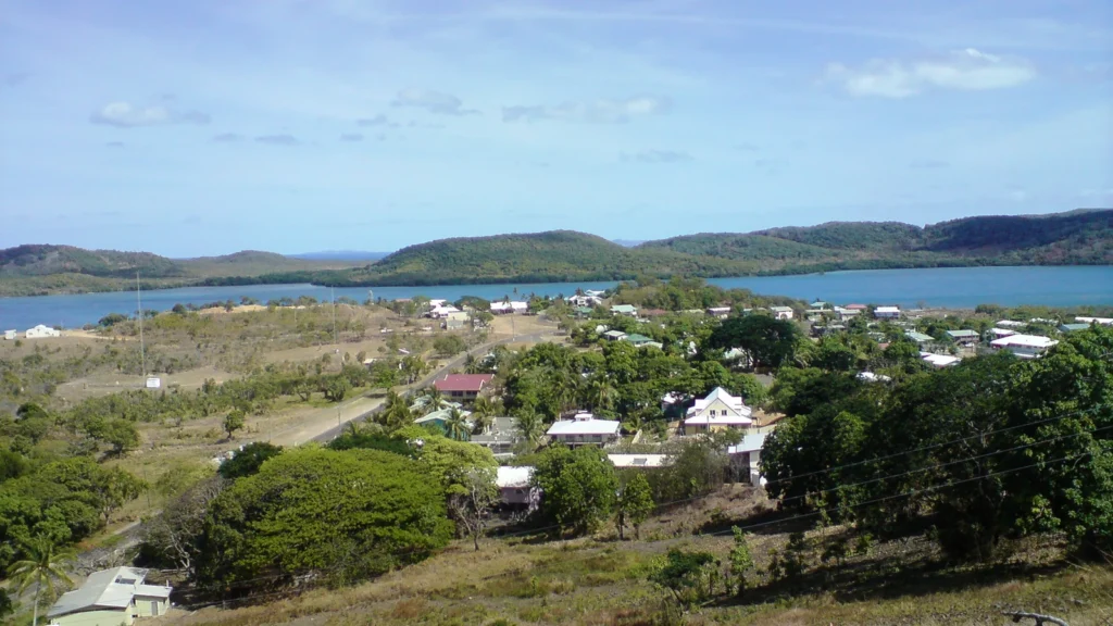
Featured photograph: Thursday Island, Torres Strait, Feral Arts, October 27, 2009 (source date), CC BY 2.0. Cropped, resized and converted to WebP.
Prepared for final factual and editorial review by Zurab Koniashvili (Z.K. Atlas). AI tools assisted with editorial preparation.
Map: GeographyPin. GeographyPin cartography. Natural Earth 1:10m land and minor islands public-domain generalized shoreline, not a current shoreline survey, reef inventory or navigation chart. Island positions and local names cross-checked against the Torres Strait Regional Authority regional map, TSRA extreme water-level study and Queensland parliamentary gazetteer annex. About 150 km is TSRA’s regional description; Australian DAFF gives about 3.6 km from Saibai Island to PNG. No exact endpoint pair, measured shoreline transect, maritime line, treaty jurisdiction, reefs, water depth or routes are plotted. Island dots are locality references where coastline is too small to depict.
Original GeographyPin treaty locator adapted from Geoscience Australia, Treaties – Australian Maritime Boundaries 2020 (CC BY 4.0), with public-domain Natural Earth shorelines. Cropped, styled and labeled for explanation. Treaty scope checked with Australia’s Department of Foreign Affairs and Trade; no maritime line is drawn from the shoreline or from a distance estimate.