The Strait of Magellan bends around the southern end of the South American mainland. On a map that includes Cape Horn, it is easy to mistake the other channels of Tierra del Fuego for branches of the same passage.
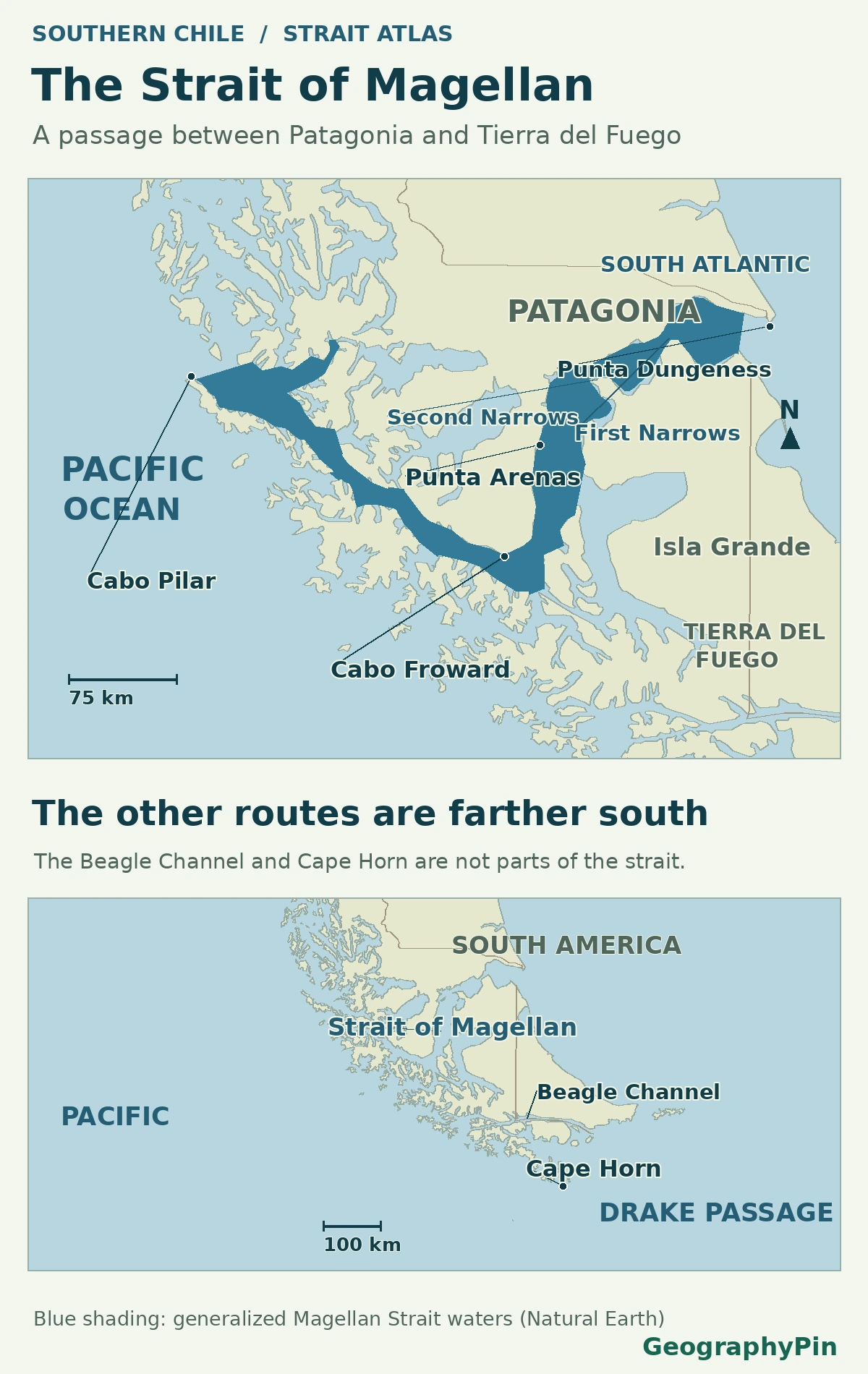
The Strait of Magellan links the South Atlantic and South Pacific through southern Chile. It runs between mainland Patagonia and the Tierra del Fuego archipelago, passes Punta Arenas, and bends west around Cape Froward. The strait lies north of both the Beagle Channel and the open-ocean route around Cape Horn.
How to use this article: Start at the Atlantic entrance, follow the turn beyond Punta Arenas, or compare the southern alternatives.
The strait between Patagonia and Tierra del Fuego
Follow the water from the Atlantic into the two eastern narrows, then past Punta Arenas and around the Brunswick Peninsula. The Chilean Navy’s geographic overview uses Cape Froward to divide the strait into eastern and western stretches. The direction change there explains more about the map than a line straight across the tip of the continent.
Punta Dungeness and the two eastern narrows
How to locate the Atlantic entrance
At the eastern end, Article 10 of the 1984 Chile–Argentina Treaty of Peace and Friendship identifies Punta Dungeness on the north side and Cabo del Espíritu Santo on the Tierra del Fuego side. An older sailing description in the Chilean National Library archive uses nearby Cabo Vírgenes as a reference on the north side. Cabo Vírgenes and Punta Dungeness are different features, not two spellings of the same point.
Farther inside are Primera Angostura and then Segunda Angostura, the first and second narrows when reading the map from the Atlantic. The two constrictions have wider water between them. They are within the strait, not separate Atlantic mouths.
Punta Arenas, Paso Ancho and the bend at Cape Froward
The city’s waterfront comes before the turn
Punta Arenas is on the mainland side of the strait, on the Brunswick Peninsula. The broader section of water here is known as Paso Ancho. Follow the peninsula south from the city and the mainland landmass ends at Cape Froward, where the strait turns toward the Pacific. The cape marks the southern tip of mainland South America, not the southern tip of its offshore islands.
On a small map, the city can look as though it lies beside a narrow, straight crossing. The map in a field study of the northeastern strait shows the contrast: the water opens up south of the narrows around the city before bending around the peninsula.
The Pacific end and the separate route past Cape Horn
Cape Pilar, Cape Horn and the Beagle Channel are different places
West of Cape Froward, the strait runs between the mainland and offshore islands. Chile’s official list of waterways traces its through-route west via named sections including Paso Tortuoso and Paso del Mar to Cape Pilar, at the Pacific end. Other channels branch off the western stretch into the Patagonian archipelago, but they are not needed to connect the strait’s two mouths.
A route around Cape Horn goes south of an island far beyond the strait rather than through it. The Beagle Channel is another east–west passage farther south, off the opposite side of the large island of Tierra del Fuego. Chile’s overview of the southern channels shows it as a distinct waterway reached through intervening channels, not another name for the Strait of Magellan.
Why the Atlantic and Pacific ends have different tides
In a 1988 analysis of tides along the strait, the reported mean range was about 23 feet (7.1 m) at the Atlantic side and 3.6 feet (1.1 m) at the Pacific side. These are typical vertical differences between high and low water at the respective ends in that study, not depths or current speeds.
The study found that the shape of the eastern entrance initially amplified the tide, then the two narrows restricted its transmission farther west. Width is only part of that explanation: tidal range was not a smooth east-to-west slope, and a coastline alone cannot show the tidal phase or the movement of the water. A 2024 field study measured strongly variable flow and turbulence within Segunda Angostura itself, at a much smaller scale than the full strait.
Frequently Asked Questions
What does “Canal de Todos los Santos” mean on older records?
That is an early European name for the same passage, “Channel of All Saints.” The Chilean National Library’s account of Magellan’s expedition records the name. Modern Chilean sources use Estrecho de Magallanes.
Which source gives the Chilean names used on charts?
The Chilean maritime authority identifies the Servicio Hidrográfico y Oceanográfico de la Armada (SHOA) as the publisher of national nautical charts. Estrecho de Magallanes and the English Strait of Magellan refer to the same waterway.
Why do maps show more than one line at the western end?
They may show different adjoining channels or offshore approaches. The Chilean waterway list identifies Cape Pilar as the end of the through-route, then lists other channels separately. A route endpoint does not by itself define all neighboring sea areas.
Was the strait unused before Magellan?
No. The Chilean National Library’s account of Indigenous peoples of the southern channels documents Kawésqar presence in the western channel region down to the strait. The early European name records a voyage, not the beginning of human use.
What Did We Learn Today?
The Strait of Magellan is the inland water connection between the South Atlantic and South Pacific past Punta Arenas and Cape Froward. Cape Horn is an island headland farther south, and the Beagle Channel is a different passage. The map explains the bends and narrows; observations explain why tides differ so strongly from one end to the other.
Sources & Data Notes
The entrance references come from the Chile–Argentina treaty and Chilean hydrographic and maritime sources. Historical names come from the Chilean National Library. Tidal values are historical study means at the named ends, not predictions; the map is for geographical orientation. AI tools assisted in preparation.
Map: GeographyPin. The generalized coastline and boundary data come from Natural Earth 1:10m, public domain. Landmark positions and names follow the Chilean Navy geography and Chile’s maritime authority in regional context. Neither a line of sovereignty claims nor an operational route is depicted. Distances can be measured from different offshore reference points. This is an atlas illustration, not a chart.
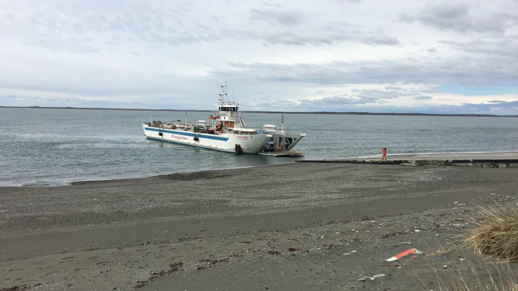
Strait of Magellan crossing 2, Fredlyfish4, December 22, 2015, CC BY-SA 4.0. Cropped, resized and converted to WebP; this adapted image remains CC BY-SA 4.0. The photographer’s optional permission-page notice is not a requirement.
The main position of the strait follows the public-domain Estrecho de Magellanes feature from Natural Earth’s 1:10 million marine polygons, selected and styled for this figure. The shading does not mark the legal limits or give sailing guidance.