The Fraser makes a broad turn through the interior of British Columbia before reaching the coast. On a regional map the river looks like one line, but near Vancouver its branches pass on different sides of the same islands.
The Fraser River starts in the Rocky Mountains near Fraser Pass, runs northwest before turning south by Prince George, and crosses the Fraser Canyon. Below Hope it heads west into a delta south of Vancouver, where several channels open to the Strait of Georgia, part of the Salish Sea.
How to use this article: Locate the source and the inland turn, find the New Westminster split, or check what the tidal limit means.
Fraser Pass, the Rocky Mountain Trench and the turn south
The river starts before it reaches the trench
The Fraser River Discovery Centre places the headwaters near Fraser Pass. The British Columbia names register traces the upper river northwest out of the Rocky Mountains and then south from Prince George. A map pin marks the mountain source area, not a guaranteed place to stand beside a single spring.
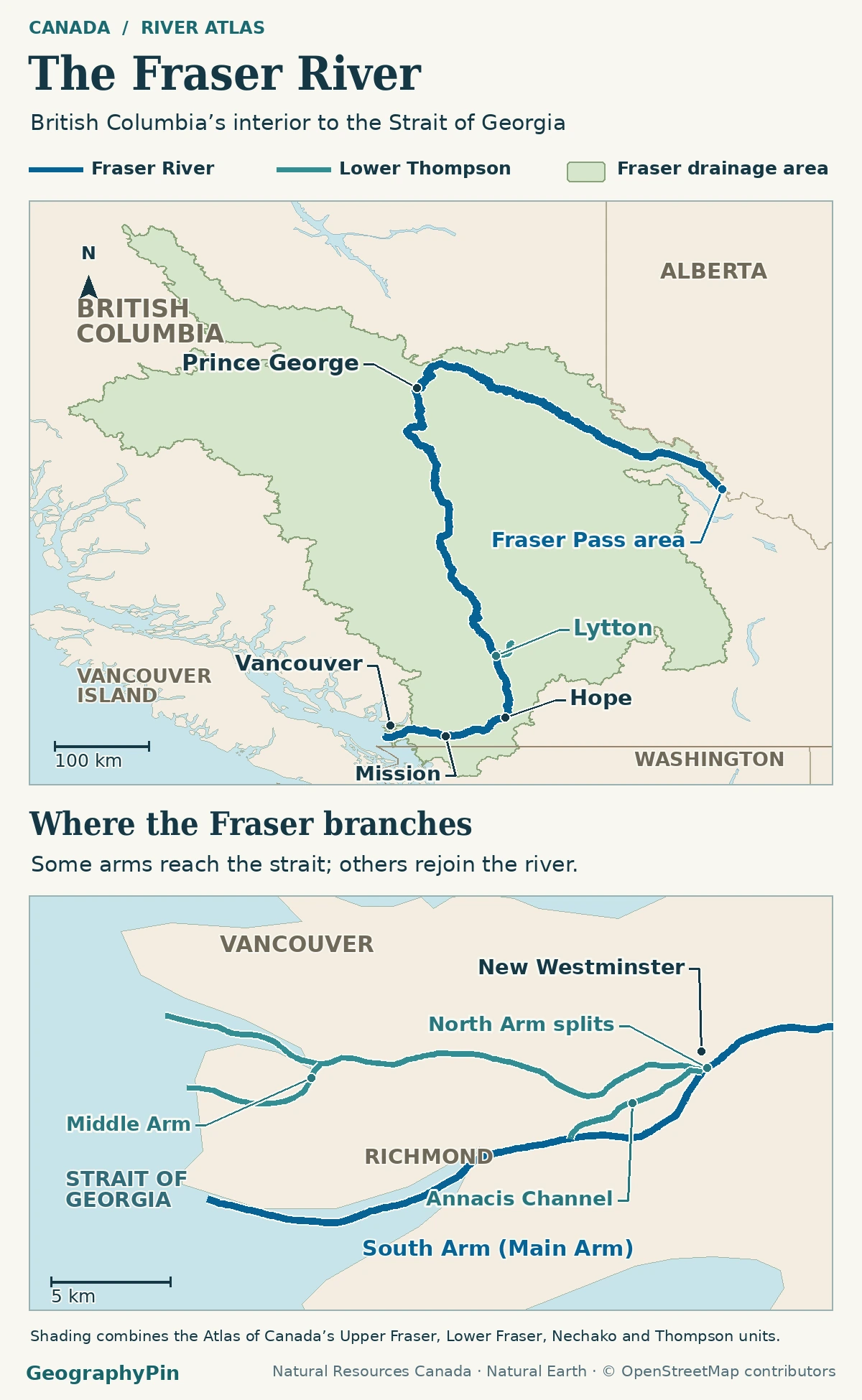
Part of the upper course follows the Rocky Mountain Trench, a long valley alongside the Rockies, before the river crosses the interior. The Nechako joins near Prince George, after which the main Fraser travels south toward the canyon country. The trench is a landform; it is not the name of a separate feeder river.
The Thompson junction, Fraser Canyon and lower valley
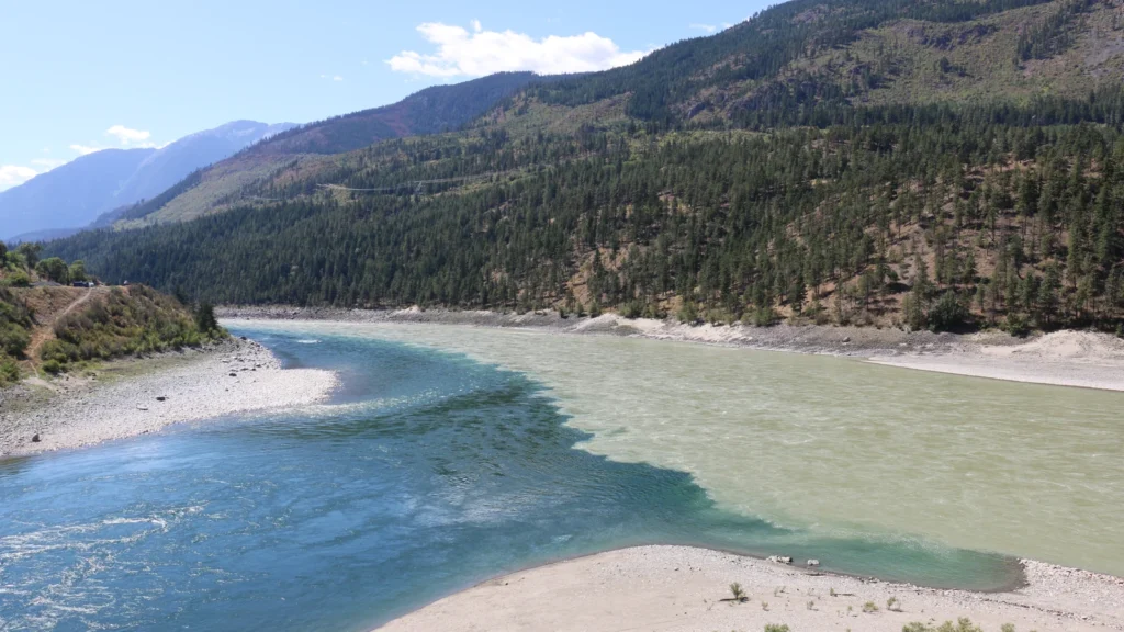
At Lytton, the Thompson River arrives from the east, as shown in the province’s geographic description of Lytton First Nation. Downstream the main river passes through the steep Fraser Canyon and its constricted Hell’s Gate reach. Hell’s Gate is one narrowing in the canyon, not its other name.
Below Hope the valley opens out. A British Columbia study of the lower river describes a lower gradient, with gravel bars and channels that separate around islands before reconnecting. Those short splits are not yet the main delta branches that take separate paths toward the sea.
Where the river branches near Vancouver
Start with the split by New Westminster
At New Westminster, the provincial lower-river study distinguishes the South Arm (often called the Main Arm), the North Arm and Annacis Channel. The Annacis Channel rejoins the main arm farther downstream. The North Arm continues toward the Strait of Georgia and has its own branch, the Middle Arm, on the way to the coast. These labels matter: three names at the split do not imply three independent mouths there.
The provincial North Arm name record places it between Vancouver and the Lulu and Sea Island sides. The South Arm lies on the other side of Lulu Island and continues past the Steveston area. Beyond the banks, broad tidal flats at Sturgeon Bank and Roberts Bank form part of the delta front.
Downstream of the tide reference is not the same as below high-tide elevation
A map can show the delta’s banks, islands and channels downstream of Mission, but that location does not establish how high any parcel lies above the tide. A provincial estuary study traced a water-level tide signal as far as Chilliwack in low-flow conditions and no farther than Mission in higher flows. In that sense the delta islands are well downstream of the tidal limit, while the position of the upstream limit itself varies.
Where the drainage area crosses the border
The Fraser’s main river lies in British Columbia. Its natural drainage does not stop at the border. The Canada Water Agency identifies roughly 250 square miles (640 square kilometers) of the lower watershed in Washington, including land feeding the Sumas River. That land contributes without the Fraser crossing into the United States.
| Reference | River length | Basin area |
|---|---|---|
| Atlas of Canada table | About 851 miles (1,370 km) | About 89,700 sq mi (232,300 km²) |
| Canadian Heritage Rivers System | About 854 miles (1,375 km) | About 84,900 sq mi (220,000 km²) |
Use the source beside the figure. The public summaries do not supply enough matching detail to assign their different area totals to one particular boundary choice. Neither area is a measurement of the delta alone.
A flow comparison at Hope, upstream of the delta
The Water Survey of Canada records for Fraser River at Hope (08MF005) give a mean discharge of about 31,400 cubic feet per second (889 m³/s) in February 2018 and about 217,000 cubic feet per second (6,140 m³/s) in June 2018. They are two monthly means at the same station, illustrating the difference between winter flow and a month in the spring snowmelt season.
Hope is upstream of both the tidal delta and some tributary junctions. Water in the delta is split among branches and also affected by tides. The figures do not give the June flow in any particular arm or this year’s conditions.
Frequently Asked Questions
Does the tidal limit also mark the saltwater limit?
No. A tide can raise and lower fresh water upstream of where saltwater reaches. The provincial river and estuary profile describes a lower-river salt wedge that changes seasonally with river flows and daily with the tide.
Is the main Fraser River dammed?
The Canadian Heritage Rivers System reports no dam on the main stem. Some tributary flows are regulated, which is a separate question: a dam elsewhere in the basin is not a dam across the named Fraser.
Can a map use one marker for the Fraser’s mouth?
Yes, as a locator. The BC names register gives one approximate mouth position for the feature, while the estuary map shows multiple named channels and outlets. One point is not an official claim that only that channel reaches the strait.
Why does an old map call an inland stretch the South Fork Fraser River?
The BC names register says that name was sometimes used for the inland stretch between Yellowhead Lake and Prince George. It is not the South Arm at the delta near Vancouver.
What Did We Learn Today?
The Fraser runs from the Rocky Mountains through British Columbia’s interior and canyon to a branching delta on the Strait of Georgia. The drainage area extends slightly into Washington while the river itself does not. Follow the coastal branches for outlet geography and treat the upstream tidal influence as a changing water-level effect, not a fixed boundary on land.
Sources & Data Notes
The references include the British Columbia Geographical Names Office, the Fraser River Discovery Centre, Statistics Canada, the Canada Water Agency, Canadian Heritage Rivers, provincial lower-river studies and Water Survey of Canada historical records. Basin and length figures use the named sources; the discharge comparison applies only to the two months at Hope. AI tools assisted in preparation.
Map: GeographyPin. Original GeographyPin cartography. Drainage shading combines the Upper Fraser, Lower Fraser, Nechako and Thompson sub-drainage areas in the Atlas of Canada Watersheds; contains information licensed under the Open Government Licence – Canada. Selected waterways © OpenStreetMap contributors (ODbL); generalized shoreline and administrative outlines Natural Earth.
Fraser joins Thompson River at Lytton, The Interior, CC BY-SA 4.0. Cropped minimally, resized and converted to WebP; this adapted image remains CC BY-SA 4.0.