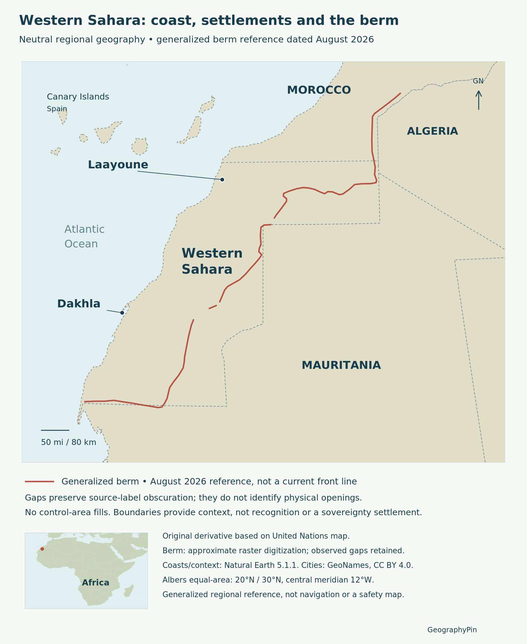
Western Sahara is both an Atlantic desert territory and an unresolved political question. A useful map must distinguish its outline from the military berm and from the areas administered by different parties. None of those lines, by itself, settles sovereignty.
Western Sahara is a disputed territory on Africa’s Atlantic coast, listed by the United Nations as Non-Self-Governing. Morocco administers most of it and claims sovereignty; the Polisario Front controls territory east of the berm and seeks independence. Desert landscapes, coastal settlements and a divided territorial administration must be understood separately from final legal status.
How to use this article: Locate coastal settlements, follow the berm and control, or compare mission closure and status.
1. Locate the Atlantic Territory and Its Settlements
Coastal cities and neighboring countries
The Atlantic lies to the west, Morocco to the north, Algeria at the northeastern edge, and Mauritania along the eastern and southern margins. Western Sahara is a specific territory, not a name for the entire western half of the Sahara Desert.
Laayoune, also written Laâyoune or El Aaiún, lies near the northern coast. Dakhla is farther south on a narrow coastal peninsula. These city labels orient the reader; neither is used here as the uncontested capital of a sovereign state.
2. Read a Desert Coast, Not an Unbroken Sand Sea
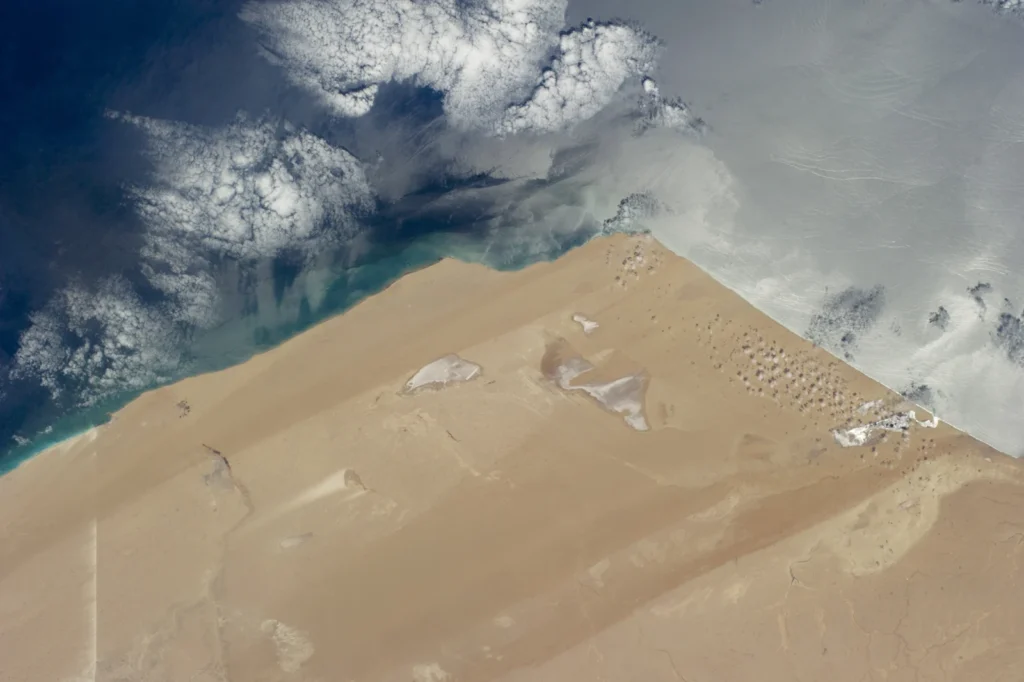
NASA’s May 20, 2014 astronaut photograph shows sand streaks alternating with sand-free surfaces along an extremely arid Atlantic coast. Strong northerly winds help produce those elongated patterns. Desert does not mean that every visible surface is a dune.
Near the shore are salty depressions or lagoons known as sabkhas. Waves also erode the coast and move sediment into the water. These features connect the dry land to active coastal processes rather than forming an entirely separate marine landscape.
NASA identifies an inland-to-coast phosphate transport corridor in the same historical image. It illustrates how extraction and transport connect desert interiors with the ocean, but it does not establish today’s production, ownership or export totals.
3. Separate the Berm, Control and Sovereignty
The berm is not an agreed international border
The UK Foreign, Commonwealth and Development Office describes the berm as the militarized division between Moroccan-controlled territory and territory to the east controlled by the Polisario Front. This is a broad description of control, not a legal determination of sovereignty or a guarantee of access.
Morocco’s sovereignty claim concerns Western Sahara as a whole; the Polisario Front seeks independence. A map that colors an administrative area as an ordinary, undisputed country outline would collapse those different questions into one symbol.
| Question | What the evidence describes |
|---|---|
| Where is the territory? | The geographic outline, coast and neighboring territories. |
| Who controls an area? | Administration and military presence, broadly divided by the berm. |
| What is its final status? | An unresolved sovereignty and self-determination question. |
The dated berm line is an orientation layer, not a live front-line survey. Keep it distinct from the territory’s outer outline and from the parties’ claims. A geographic overview is not a route-planning or security map.
4. UN Status, Political Claims and the November 2026 Change
The end of a mission is not a territorial settlement
Western Sahara has appeared on the UN list of Non-Self-Governing Territories since 1963. The UN’s decolonization entry records Spain’s 1976 notification ending its presence but does not designate Morocco as the administering power. De facto Moroccan administration and the UN’s legal classification are therefore different descriptions.
The African Union lists the Sahrawi Arab Democratic Republic as a member. AU membership is an institutional fact; it does not establish universal recognition or show which authority controls every place on the map.
Status information here is dated November 18, 2026. The UN announced that MINURSO’s mandate expired on October 31 and that liquidation began on November 1. Liquidation means winding down the mission and dealing with personnel and assets, not that everything disappeared on that date.
The Secretary-General reaffirmed continuing UN support for a political solution and the people’s right to self-determination. Ending peacekeeping operations did not settle sovereignty. The October 2026 Secretary-General’s report likewise described Morocco’s draft autonomy statute as a basis for negotiations, not an agreed outcome.
5. Displacement Extends Beyond the Territory’s Outline
The October 2026 UN report describes humanitarian assistance to Sahrawi refugees in five camps near Tindouf, Algeria, and continuing separation from communities of origin in Western Sahara. Those camps lie outside the territory: refugee populations there should not simply be added to a resident count for Western Sahara.
For any population comparison, first identify whether the figure covers the territory, Moroccan administrative regions, camps in Algeria or a wider community. These are different geographic populations. A number without that coverage cannot support a meaningful density calculation or a comparison between cities and the whole territory.
What Did We Learn Today?
Western Sahara’s desert coast, cities and surrounding countries provide the geographic frame. The berm describes a division of control, not a settled international border. Claims, UN territorial status and institutional membership answer different questions, while the November 2026 mission drawdown does not itself resolve the dispute.
Sources & Data Notes
Sources, dates and map conventions
Status is referenced to November 18, 2026. The October Secretary-General’s report and its August map predate the mission’s liquidation; former operational sites must not be presented as current deployments. No combined population, control percentage or sovereignty recognition count is inferred.
- UN decolonization: Western Sahara’s territorial listing
- UK FCDO: disputed territory and the berm
- UN Secretary-General: report S/2026/781, October 1, 2026
- UN Secretary-General: statement on the end of MINURSO’s mandate
- African Union: member-state roster
Featured photograph: Saharan Atlantic coast, NASA/JSC, Expedition 40 crew, May 20, 2014 (ISS040-E-788). NASA-enhanced contrast; full frame resized and converted to WebP. NASA media-use guidance.
Original map derivative: approximate raster digitization, not a local survey. Source-label obscurations remain gaps; they do not locate physical openings. UN derivative-map permission. Neutral context uses Natural Earth 5.1.1, public domain; city points use GeoNames, CC BY 4.0. Albers equal-area projection. Generalized source geometry does not support precise local comparisons.