Tokelau’s three names on a Pacific map represent much more than three dots of land. Atafu, Nukunonu and Fakaofo are atolls, each combining a lagoon, reef and narrow inhabited islets. Their ocean separation helps explain how communities obtain water, maintain connections and organize public services.
Tokelau is a non-self-governing territory within the Realm of New Zealand, comprising Atafu, Nukunonu and Fakaofo in the South Pacific. These are three low coral atolls, not three solid islands. Their narrow islets surround lagoons, while communities remain separated by ocean. Tokelau’s status differs from the free-association arrangements of the Cook Islands and Niue.
How to use this article: Locate the three atolls, follow the lagoon and rim, or compare settlement patterns.
1. Locate Atafu, Nukunonu and Fakaofo
Three atolls spread across the ocean
Tokelau lies roughly 310 miles (500 km) north of Samoa, according to New Zealand’s May 2025 country plan. Atafu occupies the northwestern end of the group, Nukunonu the middle and Fakaofo the southeastern end. The map preserves those relative positions rather than arranging the names as if they were adjacent villages on one island.
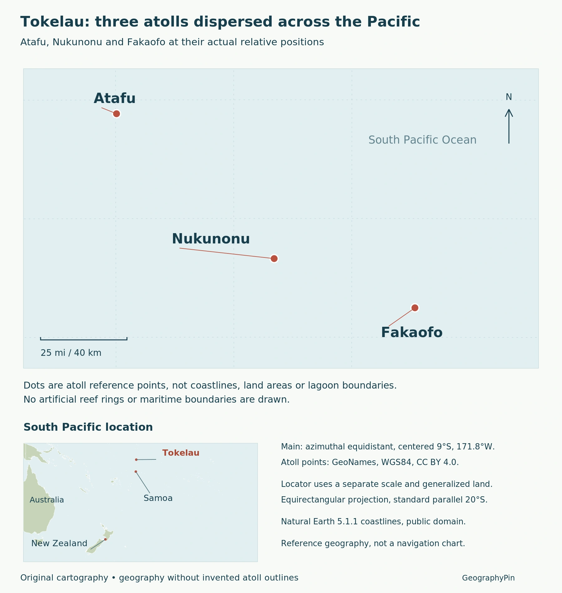
The three symbols are atoll reference points, not outlines drawn to scale. They locate the group within the South Pacific but do not show the shape of a reef, the area of a lagoon or the amount of usable dry land. A line connecting them would be a map-reading aid, not a continuous landmass or a territorial sea boundary.
For wider regional orientation, the world country atlas provides the surrounding Pacific context. The close-up here answers a different question: where Tokelau’s three atolls lie in relation to one another.
2. Separate the Islets, Reef and Lagoon
An atoll is not a solid disk of land
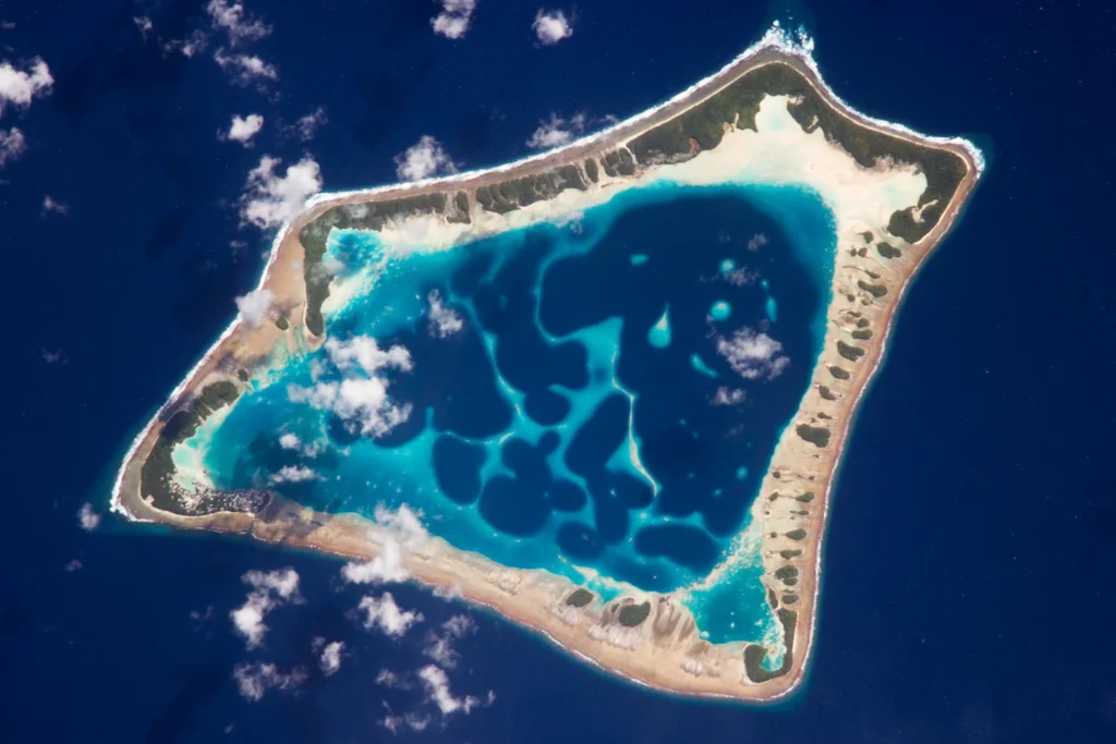
Tokelau’s 2019 disaster-resilience plan describes strings of narrow coral islets, or motu, joined by reef flats around lagoons. Dry land is only part of this system; the area inside the rim also includes water.
The featured astronaut photograph shows Atafu’s lagoon and narrow surrounding rim on January 6, 2009. Open central water is visually prominent, while land occupies much narrower margins. This is a real view of one atoll, not a plan of all three or a present-day reef-condition assessment.
That distinction also helps when comparing other Pacific places. Niue’s raised coral landscape preserves an older atoll structure above sea level; Tokelau’s low motu and open lagoons present a different physical setting. The word “coral” alone does not imply identical terrain.
3. Read Settlements at the Scale of Individual Islets
Fakaofo and Nukunonu are more than one village dot
The Government of Tokelau’s villages account identifies two settlements on Fakaofo: Fale and Fenuafala, on separate islets. Fenuafala developed as a second settlement in 1960 as the population grew. A single dot labeled Fakaofo therefore locates an atoll, not every house or the entire settlement pattern.
On Nukunonu, Fale and Motuhaga are linked by a bridge. Here a short built connection joins neighboring settlement areas within the atoll. It should not be confused with the much larger ocean separation between Nukunonu and the other two atolls.
These examples show why three scales matter: the territory comprises dispersed atolls; each atoll contains multiple land and water features; settlements occupy particular parts of that land. Village geography is more precise than treating the whole reef rim as one inhabited island.
4. Connect Low Land With Water and Transport
Tokelau’s 2019 resilience plan identifies roof-collected rainfall as its principal drinking-water source, with limited well supplies. Coral-sand soils restrict food crops. The lagoon is not a freshwater reservoir.
The plan describes shipping connections through Samoa and between atolls. This is a dated transport account, not a sailing timetable: movement within an atoll differs from an inter-atoll ocean passage.
The May 2025 country plan identifies reliable transport and communications as essential to service delivery. It also treats drought, cyclone impacts, tidal surges and sea-level rise as important resilience concerns. Low land and geographic dispersal mean that freshwater storage, coastal exposure and connections between communities belong in the same geographical account.
5. A New Zealand Territory, Not a Free-Association State
New Zealand’s foreign ministry describes Tokelau as a non-self-governing territory whose administrative powers have progressively been devolved. It has its own institutions, judicial system and public services. Tokelauans are New Zealand citizens, while New Zealand retains responsibilities including international obligations, defence and security in close consultation with Tokelau.
The General Fono contains representatives from the three atolls. The Ulu o Tokelau role rotates annually among their Faipule, or leading representatives. Rotating leadership describes an institutional arrangement; it should not be turned into an unsupported claim that a geographic capital moves each year.
Referendums in 2006 and 2007 did not reach the two-thirds majority required for a change to self-government in free association. Tokelau therefore should not be assigned the same status as the Cook Islands or Niue simply because all three have connections with New Zealand. Shared regional relationships do not erase their constitutional differences.
What Did We Learn Today?
Tokelau is best understood as three dispersed atolls containing narrow islets, reef flats and lagoons, not three solid islands. Settlements occupy specific islets, while water supply and transport connect local geography with wider ocean distances. Its institutions operate within a non-self-governing territorial relationship with New Zealand, distinct from the free-association states elsewhere in the region.
Sources & Data Notes
Sources, dates and map conventions
Water-supply and shipping descriptions use Tokelau’s November 2019 resilience plan; they are not live service or water-quality reports. The 2025 country plan supplies regional orientation and resilience priorities. No numerical population total is combined from differently scoped releases. The locator uses geographic reference points rather than invented reef outlines.
- New Zealand MFAT: Tokelau’s current constitutional relationship
- New Zealand MFAT: Tokelau Country Plan, May 2025
- Government of Tokelau: resilience plan, November 2019, page19
- Government of Tokelau: villages and settlement geography
- Australian DFAT: 2006 and 2007 referendum outcomes
Featured photograph: Atafu, NASA/ISS Expedition 18 crew, Johnson Space Center, January 6, 2009. NASA’s published crop retained; converted to WebP. NASA image-use guidance.
Original GeographyPin locator using GeoNames atoll reference coordinates, CC BY 4.0, and Natural Earth 5.1.1, public domain, for regional context. The main map uses an azimuthal equidistant projection; the Pacific locator has a separate scale. Points are not reef outlines or land-area symbols. Not for navigation.