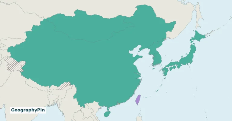
South Korea’s cities sit within a landscape of mountains, river basins, intricate coasts and offshore islands. Seoul’s Han River setting and Busan’s maritime gateway show two different relationships between terrain and settlement. Understanding those places also requires distinguishing physical geography from the country’s heavily controlled northern separation.
South Korea, officially the Republic of Korea, occupies the southern Korean Peninsula and nearby islands. Seoul is the capital; Busan is a major southeastern port. Mountains, river basins and coastal sites shape settlement opportunities, but jobs, institutions and transport networks also explain urban concentration. Jeju adds a distinct volcanic island landscape south of the mainland.
How to use this article: Compare physical regions, understand monsoon seasons, follow Seoul’s river basin, or check population coverage.
1. Locate South Korea and Read the Northern Separation
The country is not the whole Korean Peninsula
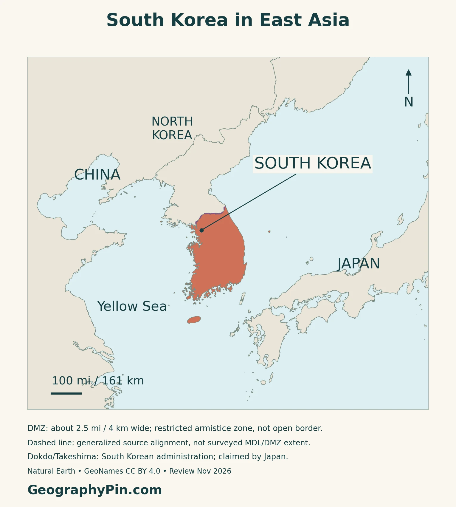
North Korea lies to the north. The Yellow Sea is west of South Korea, the Sea of Japan, called the East Sea in Korea, is to the east, and the Korea Strait separates the southeastern coast from Japan. Jeju lies south of the mainland.
The DMZ is not an ordinary open border
The 1953 Korean Armistice Agreement established a Military Demarcation Line and required each side to withdraw about 1.24 miles (2 kilometers), creating a buffer roughly 2.5 miles (4 kilometers) wide. The line runs near the 38th parallel but does not simply follow that latitude.
Entry into the Demilitarized Zone is restricted under the armistice framework. A map label does not identify an unrestricted crossing or visitor route. The marker here identifies the Panmunjeom area; it does not trace the full zone’s width.
Separate administration from territorial claims
The small islets known as Dokdo in South Korea and Takeshima in Japan are administered by South Korea and claimed by Japan. The maps identify that qualification rather than treating the disputed sovereignty as settled.
For the surrounding countries, see the East Asia countries map.
2. Mountains, River Basins and a Volcanic Island
Eastern highlands contrast with basins and indented coasts
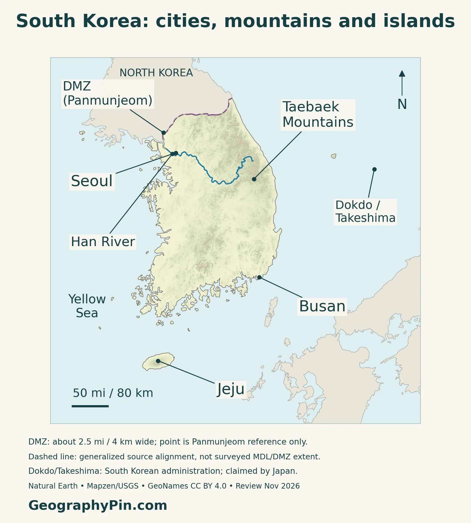
The National Atlas describes an uneven mountain distribution, with much of South Korea’s higher terrain toward the east. The Taebaek range is a key reference. Resistant rocks form rugged ground, while erosion of less resistant material helps produce lower basins and valleys.
The eastern shoreline is relatively straight compared with the more indented western and southern coasts.
| Reference area | Physical setting | What to notice |
|---|---|---|
| Taebaek Mountains | Eastern mountain spine | Higher relief near the eastern side |
| Seoul and the Han River | Northwestern basin and river corridor | City neighborhoods coexist with surrounding mountains |
| Busan and the Nakdong estuary | Southeastern coastal setting | Port city beside river-mouth and coastal habitats |
| Western and southern coasts | Indented shorelines | Bays, islands and tidal environments |
| Jeju | Island south of the peninsula | Volcanic landforms distinct from mainland ranges |
Jeju is more than a detached piece of mainland terrain
Jeju’s volcanic history produced several different landforms. UNESCO’s World Heritage property brings together Hallasan, the Geomunoreum lava-tube system and the Seongsan Ilchulbong tuff cone.
A mountain, an underground lava passage and a coastal cone record different aspects of volcanic processes. Their relationship explains why Jeju needs its own geographic context instead of being treated as a small copy of the mainland.
3. Monsoon Seasons, Rivers and Living Coasts
Continental and oceanic influences meet
The Korea Meteorological Administration describes a climate influenced by both the Eurasian continent and the western Pacific. Summers are much warmer than winters, and the seasonal wind pattern brings a summer rainy period known as Changma, also romanized jangma.
Rainfall is strongly seasonal rather than evenly distributed through the year. Heavy summer rain can cause flooding, while typhoons can also affect the peninsula. Winter is generally drier, although some districts receive substantial snow.
At Busan, a river becomes a coastal ecosystem
The Nakdong estuary links river water with the sea. Busan’s geopark describes sand bars, dunes, lagoons and wetland habitats around this transition. River-mouth environments also supported farming and fishing before the modern urban landscape expanded.
Sediment-built islands and shallow-water habitats are part of the landscape used by migratory birds. They also show why a port-city label does not describe every part of Busan’s coast.
The western and southern shores have tidal-flat habitats
The Getbol World Heritage property protects selected Korean tidal flats along western, southwestern and southern coasts. Its components include estuarine, open-coast, island-associated and partly enclosed environments.
These wetlands provide feeding and stopover habitat along the East Asian–Australasian Flyway. Their exposed mud and sand are not empty coastal land: the organisms and sediment surfaces are part of a productive ecological system. UNESCO’s current description records the property’s extension in 2026; the designation does not cover every Korean tidal flat.
4. Why Cities Cluster in Particular Corridors
Seoul developed among mountains beside the Han
The Seoul Institute describes the historic urban basin within surrounding mountains, with the Han flowing east to west through the wider city landscape. Tributaries run between the hills, and the old royal palaces occupied the basin north of the main river.
This setting helps explain why a metropolitan landscape can contain both densely developed ground and prominent mountains. “Urban” and “mountainous” are not mutually exclusive descriptions. The river corridor supplies a useful map reference without implying that the whole capital is flat.
Busan combines a coastal gateway with an industrial history
Busan’s city government emphasizes its position beside the Korea Strait and international shipping routes. The opening of its international port in 1876 helped it develop as a center of trade and industry.
Its growth also reflected wartime displacement and later movement toward industrial employment. Coastal access mattered, but the city’s history cannot be reduced to the presence of a harbor. The port and the surrounding mountains, river and neighborhoods form different parts of the same city.
Terrain sets opportunities, but institutions reinforce concentration
The geographic explanation is a combination: basins and coastal corridors offer usable sites and connections, while economic decisions determine how intensively they develop. A relief map alone cannot explain why one urban region becomes much larger than another.
The OECD’s 2026 Korea survey identifies jobs, education, health services and transport networks as continuing attractions of the Seoul Metropolitan Area. Concentration can improve access to workers and services, but also brings high housing costs and congestion. That evidence adds a human explanation to the terrain pattern rather than treating mountains as the sole cause of urban concentration.
5. Country Facts with Dates and Geographic Scope
South Korea: dated country facts
| Item | Reference |
|---|---|
| Official name | Republic of Korea |
| Capital | Seoul; Sejong hosts major central-government offices |
| Resident population | 51.82 million; register-based census, November 1, 2025 |
| Surface area | About 38,765 square miles (100,401 square kilometers); UN reference year 2023 |
| Official language | Korean |
| Currency | South Korean won (KRW) |
| Government | Presidential republic |
| First-order administration | 16 divisions following the July 2026 Jeonnam–Gwangju integration |
The Capital Area is not Seoul municipality
The Ministry of Data and Statistics released the 2025 register-based census results in July 2026. The national total includes 49.71 million resident Koreans and 2.11 million resident foreigners, both rounded figures. It is not a count of Korean citizens worldwide or a citizens-only registration total.
The same census reported 26.38 million people in the Capital Area, or 50.9 percent of the national population. That wider regional figure must not be labeled “Seoul city population” or treated as a measurement of one continuous built-up area.
Capital status and government-office location are different
Seoul is the national capital. Sejong accommodates major central administrative agencies, relocated as part of the multifunctional administrative-city project. The Government Buildings Management Office explains that the project was intended to reduce metropolitan concentration.
That office location does not make Sejong a second national capital. For other national capitals, see the Asia countries and capitals list.
A recent merger changes the administrative count
Jeollanam-do and Gwangju were integrated into Jeonnam–Gwangju Integrated Special City on July 1, 2026. The resulting first-order administrative total is 16. Older references, including data organized under the 2025 structure, may still show 17 units.
What Did We Learn Today?
South Korea’s mountains, river basins and coasts provide the setting for its cities, while employment and institutions help explain their concentration. Seoul’s river-and-basin landscape differs from Busan’s coastal gateway, and Jeju has a separate volcanic story. The DMZ requires an armistice qualification, while national population, capital-region totals and administrative units each need their own date and definition.
Sources & Data Notes
Population is the 2025 resident census, not a 2026 estimate or a citizens-only registration total. The Capital Area is wider than Seoul municipality. Area follows the UN’s dated surface-area series. Administrative divisions reflect the July 2026 integration, not the older 17-unit structure. Historical city and topographic sources support enduring landscape relationships, not current service schedules. Climate discussion uses broad KMA patterns rather than its undated normals or historical extremes. Boundary notes separate armistice geography, administration and sovereignty claims.
- National Geographic Information Institute: National Atlas of Korea 2025, topography
- Library of Congress: armistice framework and DMZ restrictions
- Japan Ministry of Foreign Affairs: Takeshima claim
- Republic of Korea Ministry of Foreign Affairs: Dokdo administration
- Korea Meteorological Administration: broad seasonal climate
- UNESCO: Jeju Volcanic Island and Lava Tubes
- UNESCO: Getbol, Korean Tidal Flats, including 2026 extension
- Busan Geopark: Nakdong estuary
- Seoul Institute: topography and historic basin setting
- Busan Metropolitan City: city environment and port history
- OECD Economic Surveys: Korea 2026, geography of opportunity
- Ministry of Data and Statistics: 2025 Population and Housing Census, released July 28, 2026
- Original English register-based census release
- UNData: dated surface area and currency
- Government Buildings Management Office: Government Complex Sejong
- UK Permanent Committee on Geographical Names: South Korea factfile
- Korea Legislation Research Institute: Framework Act on Korean Language, Article 3
- National Human Rights Commission: Constitution, presidential executive framework
- National Law Information Center: Jeonnam–Gwangju Special Act, current Article 7
- National Law Information Center: Act 21446, commencement July 1, 2026
Map method: Original GeographyPin cartography uses public-domain Natural Earth countries v5.1.1, rivers v5.0.0 and boundary lines v5.1.0, real Mapzen/USGS elevation data, and GeoNames points under CC BY 4.0. All 53 source-country components are retained; this is not a complete island inventory. The Han and Namhan follow actual source channels without invented connections. The dashed northern line is a generalized source alignment, not a surveyed MDL or DMZ boundary. Panmunjeom is a reference point, not the zone extent. Dokdo/Takeshima is neutrally marked with South Korean administration and Japan’s claim distinguished. No maritime boundary is drawn. Status notes were reviewed November 2026. The cover uses a generalized geographic outline with the national flag; the separate intact flag preserves its proportions.