Venezuela brings Caribbean shores, Andean mountains, seasonally flooded plains and tepui landscapes into one northern South American country. The Orinoco helps connect those contrasting settings, but they are not interchangeable. These maps and dated facts explain how the Llanos differ from the Guiana Highlands, where Caracas fits, and why territorial claims must be shown separately from administration.
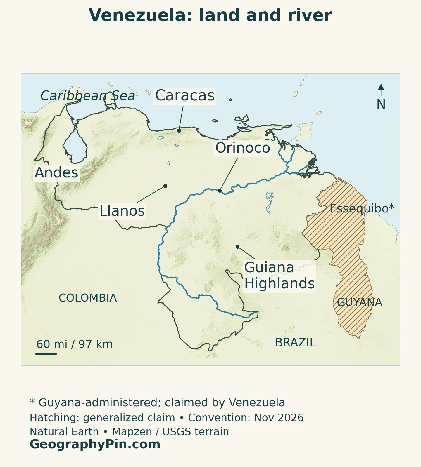
Venezuela’s Llanos are broad, low-relief plains with savannas, forests and seasonal flooding, while the Guiana Highlands are uplands marked by plateaus, escarpments and tepuis. The Orinoco links much of this landscape. Northern and western mountains, the Maracaibo lowlands, Caribbean shores and the Atlantic-facing delta add further contrasts.
How to use this article: Compare the Llanos and highlands, follow the Amazon river connection, or check the Essequibo map context.
1. Locate Venezuela between the Caribbean and the Orinoco
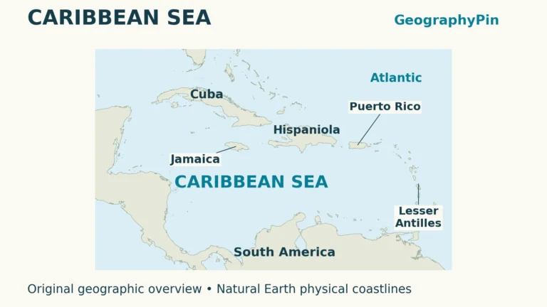
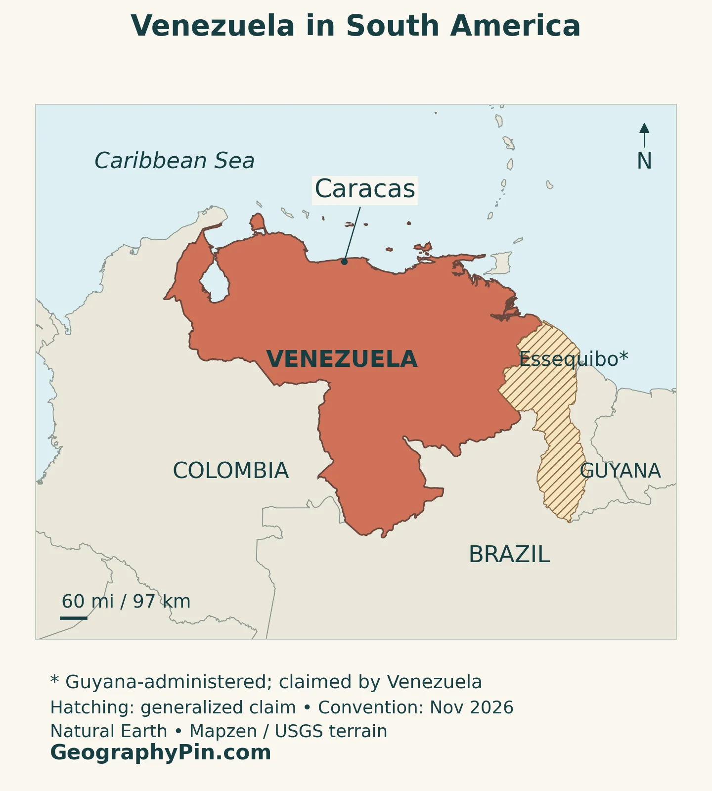
Venezuela lies on South America’s northern edge, with Colombia to the west, Brazil to the south and Guyana to the east. Its coast faces the Caribbean Sea and, farther east around the Orinoco delta, the Atlantic Ocean. Offshore islands are part of the country too, so a mainland outline alone does not describe its entire geographic extent.
The easiest way to read the mainland is to follow three large settings: mountains in the north and west, the Llanos across the central interior, and the Guiana Highlands farther south and southeast. Lake Maracaibo and its surrounding lowlands form another distinctive northwestern setting. These are physical regions, not a list of administrative states.
Reading the Essequibo claim separately
The Essequibo region is administered by Guyana and claimed by Venezuela. A claim is not the same as present administration: the map distinguishes that context rather than incorporating the region into Venezuela’s ordinary country fill.
The International Court of Justice’s case concerns the validity of the 1899 arbitral award and the related land boundary. Its May 2025 provisional measures addressed actions affecting the disputed territory, while hearings on the merits concluded on May 11, 2026. As checked on November 16, 2026, the court’s case record did not list a final merits judgment. A provisional order or a Venezuelan domestic designation should not be mistaken for a settled international boundary.
2. Country facts with dates and definitions
| Fact | Definition or value |
|---|---|
| Capital and national seat | Caracas, designated by Article 18 of the Constitution |
| Population | About 28.517 million: UN projected estimate for 2025, medium-fertility variant |
| Surface area | 358,955 sq mi (929,690 km²), UNData surface-area series, reference year 2023; not a land-only figure |
| Language framework | Spanish is official; Indigenous languages also have official use for Indigenous peoples under Article 9 |
| Currency | Bolívar |
| Constitutional organization | Federal state; states, the Capital District and federal dependencies have distinct roles |
The population figure is a projection, not a new census count or a total of all Venezuelan citizens worldwide. Residents abroad and people living within the country are different statistical populations. Likewise, an urban agglomeration, a municipality and a capital district do not necessarily cover the same Caracas.
The area above retains the named statistical series and its reference year. It is not a measurement taken from this map, and the disputed Essequibo region is not added to it as though the claim had been resolved. Maritime economic zones are also different from a country’s land-and-inland-water surface.
Administrative and physical geography answer different questions. The Constitution describes states and federal dependencies; names such as Llanos and Guiana Highlands describe landscapes that can extend across political boundaries. Keeping those categories separate makes both the map and country comparisons easier to interpret.
3. How the Llanos differ from the Guiana Highlands
Low plains versus an ancient upland landscape
The Llanos are broad plains within the Orinoco drainage system, extending across parts of Venezuela and Colombia. Their defining characteristics are relatively low relief, savannas and a pronounced seasonal water cycle. The Guiana Highlands are a more dissected upland landscape, with plateaus, steep escarpments and distinctive table mountains known as tepuis. They belong to a wider region, not just to the country named Guyana.
Neither label describes a uniform surface. FAO distinguishes piedmont savannas, higher plains and low alluvial areas within the Venezuelan Llanos. Some low basins drain slowly and flood seasonally, while slightly elevated ground stays drier. A small difference in height can therefore change vegetation, grazing conditions and access much more than a simple green plains symbol suggests.
The Llanos are not treeless throughout. A 2024 field study of forest vegetation across six Venezuelan states documented diverse forest communities, alongside the region’s well-known open landscapes. Gallery forests, palms and other wooded habitats are part of the regional mosaic rather than exceptions that make an area “not Llanos.”
| Setting | What distinguishes it | Useful map clue |
|---|---|---|
| Northern and western mountains | Steep relief and cooler conditions with increasing elevation | Andes in the west; mountain belts near the Caribbean |
| Llanos | Plains, savannas, wooded corridors and seasonally flooded low ground | Central interior, connected to the Orinoco system |
| Guiana Highlands | Uplands, escarpments and tepui landscapes | Southern and southeastern interior |
| Orinoco delta | Distributary channels, wetlands and tidal influences | Low eastern outlet toward the Atlantic |
| Maracaibo lowlands | A separate northwestern lowland basin | Lake Maracaibo beside the northern mountain systems |
Canaima National Park provides an especially clear example of the highland setting. UNESCO highlights its tepuis, cliffs and waterfalls. The contrast with the Llanos is therefore not simply “grass versus forest”: it is also a difference in landform, drainage and the way water moves through the landscape.
4. Follow the Orinoco from forest to delta
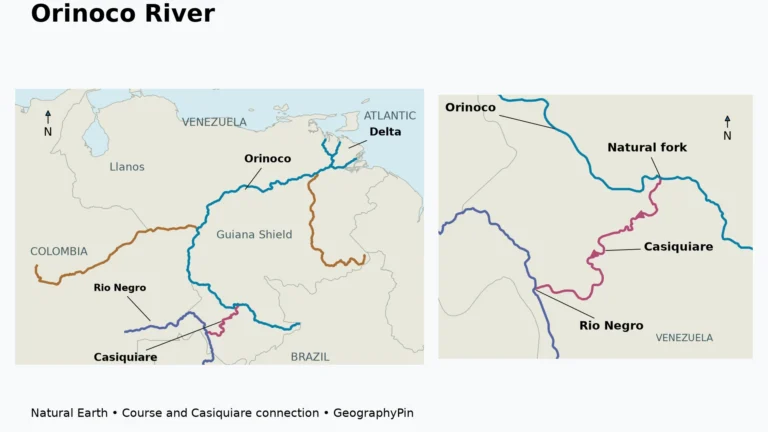
The Orinoco River connects environments that look very different on a physical map. Its upper drainage includes tropical forest, its wider system receives water from the plains and highlands, and its lower course reaches a complex delta. Treating the river as a single blue line can hide those transitions.
UNESCO describes the delta as a changing river–marine sedimentary environment, with mangroves, swamp forest, moist forest and shallow-water habitats. River channels and tidal channels divide the landscape. The coast here is therefore not equivalent to a straight sandy Caribbean shore: freshwater, sediment and marine influences interact across a broad wetland setting.
A natural connection to the Amazon
In southern Venezuela, the Casiquiare branches away from the Orinoco and flows toward the Rio Negro, which belongs to the Amazon system. NASA’s June 2025 account, illustrated with Landsat observations, explains why this is unusual: the branch does not simply rejoin the Orinoco downstream. It transfers water between two major river systems.
That connection does not mean the whole Orinoco drains into the Amazon. It is a particular branch within a larger drainage network. UNESCO’s Alto Orinoco-Casiquiare Biosphere Reserve recognizes this headwater and forest setting, where the river connection is one part of a much broader ecological landscape.
The same country can consequently include Atlantic-facing delta wetlands, Caribbean-facing coastal catchments and a natural link into the Amazon basin. Coastline and watershed are related concepts, but they are not interchangeable.
5. Climate changes with altitude and seasonal rainfall
Venezuela’s tropical latitude does not give every place the same climate. Lowland heat, cooler mountain conditions and differences in rainfall create a wide range of environments. The northwestern states of Lara and Falcón include important dry and semi-arid areas, contrasting with wetter forested settings farther south.
In the core Llanos, the year has a pronounced wet–dry rhythm. The 2024 vegetation study describes a broadly November-to-April or May dry season and a rainy period beginning around April or May and continuing toward October. These are regional patterns, not a fixed calendar for every locality or every year.
Seasonal flooding is particularly significant where flat terrain slows drainage. Water can spread over low ground during the rainy period and retreat later, changing the relationship between grasslands, forests and wetlands. Drought and excess water are therefore both relevant to land use; annual rainfall alone cannot show when water is available or where it accumulates.
Elevation adds another dimension. A mountain landscape near the Caribbean can be cooler than a nearby lowland, even at almost the same latitude. This is why a useful map separates terrain from vegetation: higher ground is not automatically forest, and a green landscape does not necessarily imply year-round abundant water.
6. Caracas, languages and lived geography
A capital beside the coastal mountains
Caracas is the constitutional capital and seat of national institutions. Its valley lies beside Waraira Repano, also known as El Ávila, a mountain barrier separating the capital from the Caribbean coast. The country’s capital is thus close to the sea without being simply a city spread along an open shoreline.
The constitutional geography also helps explain why statistics for Caracas vary: the wider urban setting reaches beyond a single administrative unit. A comparison with other South American capitals should use compatible city definitions rather than treating every published population as the same kind of count.
Spanish is the official language. Article 9 also recognizes official use of Indigenous languages for Indigenous peoples and requires respect for them throughout the country. This is more specific than either describing Venezuela as linguistically uniform or assigning every language identical nationwide administrative use.
Indigenous communities are integral to the country’s river and forest landscapes. UNESCO’s upper Orinoco account identifies Yanomami and Yekuana communities, while its delta account discusses Warao settlements. Those places are inhabited cultural landscapes, not empty wilderness surrounding a few famous natural landmarks.
7. Resources, electricity and the wider economy
Oil is central to Venezuela’s economic geography, but a petroleum reserve is not the same thing as current production or export revenue. The U.S. Energy Information Administration’s February 2024 analysis locates much of the country’s extra-heavy crude resource in the Orinoco Belt. Bringing that resource to market depends on extraction, processing, transport and functioning infrastructure.
Trade conditions also change. EIA’s November 6, 2026 update describes increased U.S. purchases that year and notes that many U.S. Gulf Coast refineries are equipped for heavy sour crude grades such as Venezuela’s. That is a dated trade relationship, not a permanent rule about where all Venezuelan oil must go.
Electricity adds a different connection between resources and landscape. EIA’s country analysis identifies the importance of hydropower and the grid’s exposure to changing water availability. Rivers matter not only for habitats or transport but also for the energy system. Oil wealth and dependable electricity are therefore separate questions.
The country is not solely an oilfield. Farming and livestock use parts of the plains, while cities support services and other employment. The contrast between wet lowlands, higher ground and wooded river corridors shapes what land can support. A clear geographic overview brings these relationships together without reducing Venezuela to either its petroleum reserves or its best-known waterfalls.
What Did We Learn Today?
Venezuela’s geography is a contrast between mountains, plains, uplands and coasts. The Llanos and Guiana Highlands differ in landform as well as vegetation, while the Orinoco connects forests, seasonal lowlands and an Atlantic delta. Caracas occupies a coastal mountain setting, and clear maps distinguish physical regions, administrative units and the unresolved Essequibo claim.
Sources & Data Notes
The population is a UN medium-variant projection for 2025, not a census. Surface area retains UNData’s 2023 series and is not land-only or a map-derived claim measurement. Constitutional descriptions identify legal provisions rather than assess political practice. Older physical-geography sources are used for stable landscape context; the 2024 energy analysis and November 2026 trade update have different reference dates. ICJ status checked November 16, 2026.
- UNData: dated population projection, surface-area series and currency
- Venezuelan Constitution: Articles 4, 9, 16–18, via WIPO Lex
- International Court of Justice: Guyana v. Venezuela case record
- ICJ: summary of the May 1, 2025 provisional-measures order
- UNDP: physical regions and climate contrasts
- FAO: Grasslands of the World, Llanos section
- Aymard-Corredor and Rangel-Ch.: forest vegetation in Venezuelan Llanos, 2024 field study
- UNESCO World Heritage: Canaima National Park
- UNESCO: Delta del Orinoco Biosphere Reserve
- NASA: the Casiquiare river connection, June 2025
- UNESCO: Alto Orinoco-Casiquiare Biosphere Reserve
- INPARQUES: Waraira Repano and the Caracas valley
- EIA: energy geography and hydropower, February 2024 analysis
- EIA: Venezuelan crude trade update, November 6, 2026
Map method: Original GeographyPin cartography uses public-domain Natural Earth country outlines, city points, rivers, lakes, physical-region references and the source Essequibo claim polygon. The claim is hatched separately from Venezuela’s country fill; the map does not resolve sovereignty. Region labels are broad references, not exact natural boundaries. Relief uses Mapzen Terrain Tiles with USGS SRTM/GMTED2010 elevation; 20 isolated negative inland source cells were replaced with original neighboring valid-cell medians for rendering only. Terrain colors indicate elevation, not vegetation. The featured-image silhouette shows the mainland and nearshore islands, excluding remote northern islands and territorial claims; it is a decorative design, not a complete territorial inventory.