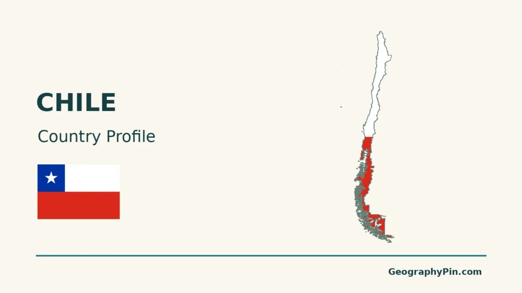
Chile is often recognized by its long outline, but its geography is more than a narrow shape. Desert basins, central valleys, Andean ranges and southern fjords respond to different combinations of latitude, water and terrain. Its Pacific islands add environments and cultural histories that a mainland-only view leaves out.
Chile is a Pacific-facing South American country with Santiago as its capital. Its long north–south extent, Andes, cold ocean current and atmospheric circulation help explain the contrast between the Atacama, central valleys and southern fjords. Pacific islands such as Rapa Nui require a separate island perspective.
How to use this article: Locate the Central Valley, compare the climate controls, or follow the difference between closed basins and ocean outlets.
1. Locate Chile along South America and across the Pacific
Chile occupies the southwestern edge of South America, facing the Pacific Ocean. Its land neighbors are Peru to the north and Bolivia and Argentina to the east. The South American territory extends from the subtropical north to the far southern islands, crossing almost 40 degrees of latitude.
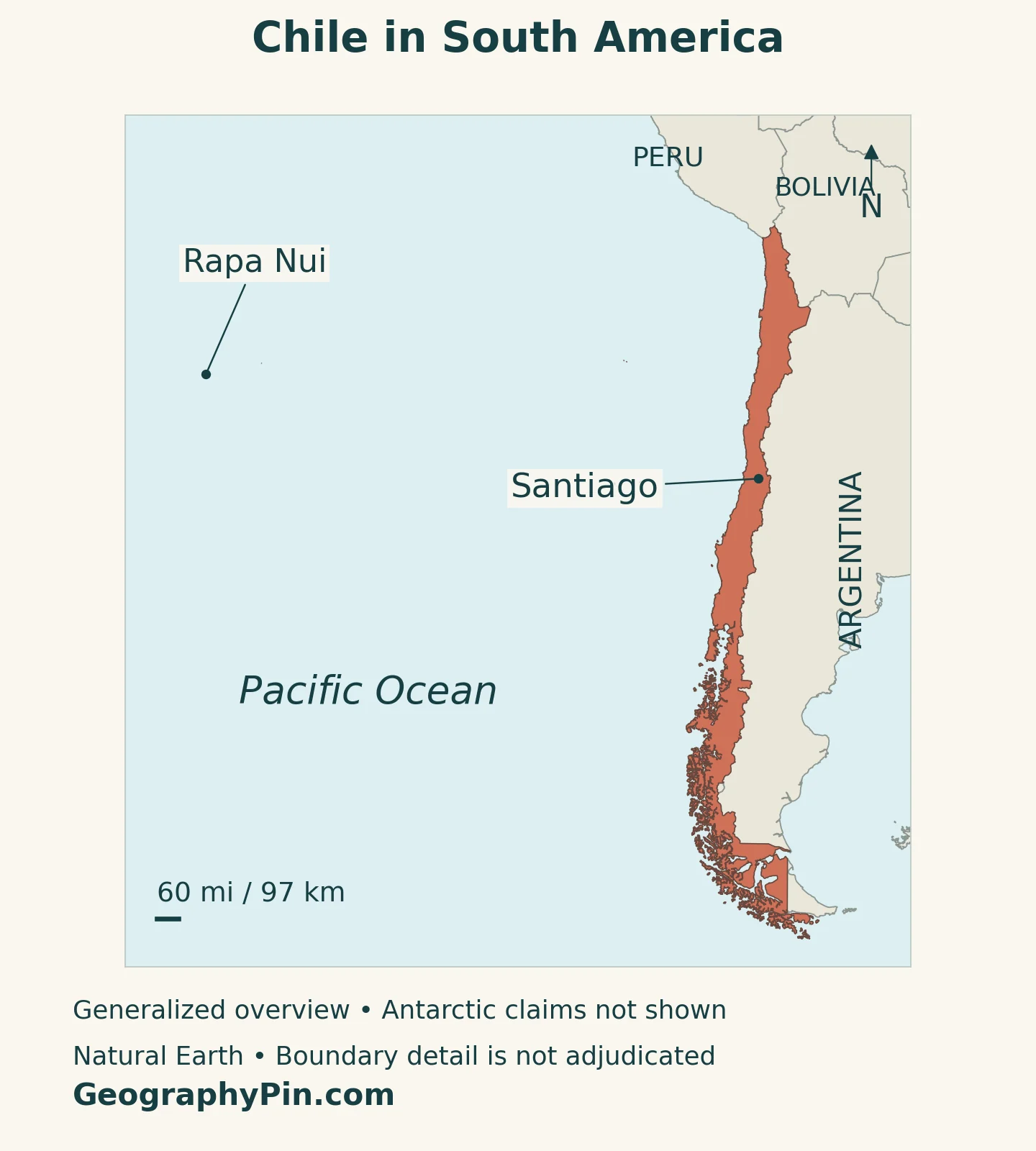
Santiago lies in the central part of the country, inland from the Pacific. Valparaíso is a coastal city with a different national role: it is the seat of the National Congress. The capital and the parliamentary seat should not be merged into one location.
Chile also includes Pacific islands. Rapa Nui, also called Easter Island, is about 2,300 miles (3,700 kilometers) from continental Chile. Juan Fernández and other offshore islands add further dimensions to the national geography. An island inset makes these territories visible, but does not place them physically beside the mainland.
Chile’s Antarctic claim is a separate matter. The Antarctic Treaty preserves the positions of claimant and non-claimant states; it does not convert the claims into universally recognized national territory. The area and maps in this profile do not add the Antarctic claim to Chile’s continental and island territory.
For its position among neighboring states, see the South American countries and capitals guide. Chile’s distinctive shape becomes more informative when read together with elevation, climate and the Pacific islands.
2. Country facts with dates and geographic scope
| Fact | Reference |
|---|---|
| Country | Republic of Chile. |
| Capital and legislative seat | Santiago is the capital; the National Congress is based in Valparaíso. |
| Population projection | 20,150,948 residents in June 2026, INE’s population projections based on the 2024 census. |
| Census count | 18,480,432 usual residents enumerated in the 2024 census. |
| Surface area | About 291,933 square miles (756,102 square kilometers), UNData reference year 2023; excludes the Antarctic claim. |
| Currency | Chilean peso (CLP). |
| Administration | 16 regions. |
| Language context | Spanish is the main national language. Indigenous languages have specific protections and continuing community use. |
The census count and the projection are not competing versions of the same statistic. INE’s projections reconcile demographic sources and apply assumptions about births, deaths and migration. The projected total includes adjustments that are not simply a count of completed census records.
Surface area is also a defined measurement. It is not land area alone, and it does not include the ocean as if territorial waters and exclusive economic zones were dry land. Adding Chile’s Antarctic claim would produce a much larger figure with a different political and geographic meaning.
3. Read Chile in two directions: north–south and coast–Andes
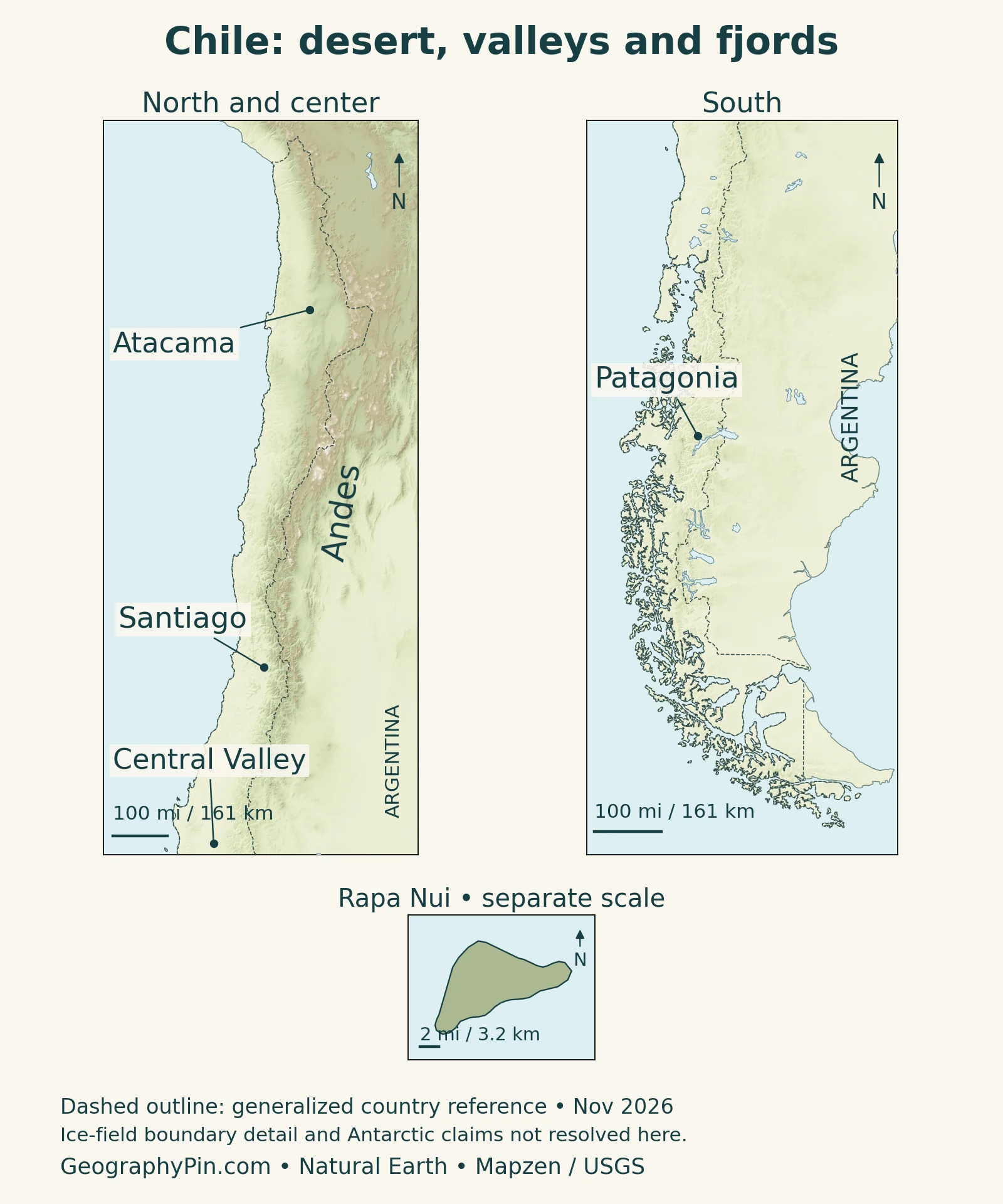
Chile’s length creates a striking north–south sequence, but a west–east cross-section is just as important. The coastal plains, Coastal Range, intermediate depression and Andes form a recurring mainland pattern. They vary in height, continuity and width; Chile is not a uniform strip bounded by a beach on one side and an unbroken wall on the other.
| Setting | What the map shows | Why it matters |
|---|---|---|
| Atacama and the northern interior | Desert landscapes, high Andean terrain and enclosed salt basins | Water availability sharply constrains settlement and activity. |
| Central Chile | Valleys and basins between coastal hills and the Andes | Santiago and important agricultural and transport corridors occupy this setting. |
| Southern lake and forest country | Wetter landscapes, lakes and mountain catchments | Rainfall and lake storage help shape river behavior. |
| Patagonian fjords and far south | Dissected coasts, islands, mountains and icefields | Waterways and steep terrain make distance more complex than a straight line on a map. |
The Central Valley is not all of Chile’s interior
The intermediate depression is a broad relief feature between the Coastal Range and the Andes. Its central portion is commonly associated with the Central Valley. Farther north, arid basins and transverse valleys complicate the pattern; farther south, the landscape becomes increasingly broken by water.
The Andes themselves continue through very different environments. High northern terrain, central mountain catchments and southern glaciated ranges do not share one climate or one appearance. An Andes label identifies a mountain system, not a single altitude or a continuous line of identical volcanoes.
USGS links much of the western South American mountain and volcanic system to subduction: the oceanic Nazca plate descends beneath the South American plate. The process helps explain uplift and seismic activity, but its geometry changes along the margin. It should not be simplified into an identical tectonic arrangement at every point in far southern Chile.
4. Why climate changes so sharply from north to south
Latitude matters, but mountains and the ocean change the result
Chile’s climate depends on its long latitudinal span, the Pacific Ocean, atmospheric circulation and elevation. The cold Humboldt Current and subtropical high-pressure conditions help maintain northern aridity, while mountain barriers influence where moist air can travel. Farther south, wetter weather systems become more important.
The Atacama is exceptionally dry, not a place where water can never arrive. NASA documented storms and flooding in early 2019 followed by vegetation growth. That example matters because a dry long-term climate does not prevent an intense rain event or make every normally dry channel safe during a storm.
Central Chile generally has a Mediterranean-type seasonal rhythm: wetter winters and drier summers. The north–south change is gradual rather than a switch at one provincial boundary. Height adds another contrast, so a high mountain location can be cold while a lower valley at the same latitude is much milder.
In the south, wetter conditions support forests, lakes and glacial landscapes. Coastal exposure and mountain shelter create local differences, so Patagonia is not one uniformly rainy environment. Nor is an icefield a description of all southern land: inhabited valleys, waterways and exposed lowlands coexist with the glaciers.
These controls explain why a single national temperature or rainfall figure is a poor guide to the country’s geography. To understand a location, identify its latitude, elevation and position relative to the ocean and mountain ranges. Rapa Nui then requires an oceanic island context rather than the mainland’s coast–valley–Andes sequence.
5. Rivers, closed basins and the southern fjords
Not all Chilean water reaches the sea by the same route. The congressional library distinguishes areas with little or intermittent surface drainage, closed inland basins, and basins with an outlet to the ocean. The contrast is especially visible in the north.
A salt basin and a Pacific-draining river behave differently
An endorheic basin retains drainage inland rather than sending it to the ocean. The Salar de Atacama is a familiar example. The Loa, by contrast, belongs to an outward-draining system. A desert label alone does not tell you whether a basin has an ocean outlet.
Central rivers can receive both rainfall and mountain snowmelt. Their seasonal flow can therefore reflect winter precipitation and later thaw, not only rain falling beside the river. Farther south, lakes can regulate flow through parts of the drainage network.
The Patagonian coast adds a different water landscape. NASA’s description of the Moraleda Channel shows how former glaciers carved connected fjords and channels into the coastal Andes. Rivers bring freshwater and sediment into these marine waterways, linking land catchments with coastal ecosystems.
A fjord is not simply a narrow river. It is a sea inlet occupying a valley shaped by glacial erosion. This distinction explains why southern maps show saltwater penetrating far between mountains and why a short direct distance may cross several channels or islands.
Water also connects environmental questions with everyday geography. Irrigation, urban supply, mining and ecosystems depend on the quantity and timing of available water. A national profile can explain the regional setting, but current allocation, drought declarations and local river conditions require more specific, dated information.
6. Cities, languages and regional identities
Santiago is Chile’s capital, but the name can refer to different urban and administrative areas. The commune, the continuous urban area and the Metropolitan Region are not interchangeable population units. The 2024 census counted 7,400,741 usual residents in the Metropolitan Region, about 40% of the national total. That measures the region, not just the central municipality of Santiago.
Valparaíso illustrates how national functions can be distributed between cities. It is both a Pacific port and the parliamentary seat. This does not replace Santiago as the capital. The distinction helps explain why maps of political institutions and maps of commercial connections highlight different places.
Spanish is the main national language, but the country’s linguistic geography is more varied. The National Cultural Heritage Service describes continuing use of languages including Aymara, Quechua, Rapa Nui, Kawésqar, Yagán and Mapuzugun. Their communities, histories and levels of use differ; they are not one undifferentiated language group.
Law 19,253 provides protections for Indigenous languages, including their use and conservation alongside Spanish in areas with substantial Indigenous populations, and educational measures. These provisions should not be mistaken for a declaration that every language has the same nationwide administrative status.
Rapa Nui is particularly important to this distinction. It is part of Chile politically while its Indigenous cultural setting is Polynesian. UNESCO’s World Heritage account emphasizes the island’s monumental sculpture and ceremonial landscapes. Recognizing that identity makes the country profile more accurate than treating all Chilean territory as culturally identical to the mainland.
7. Resources and trade connect different landscapes
Chile’s export economy links mineral resources, agricultural land, marine production and Pacific shipping. The pattern is diverse even though mining has a prominent role. A list of exports is not a map of all jobs, nor does export value measure the full contribution of each sector to domestic life.
SUBREI’s January 2026 report on 2025 trade put mining at 59.1% of national merchandise exports. Its account also identifies fruit, salmonids and other foods, forestry products, manufactured goods and wine. These dated examples show why Chile should not be described only as a copper economy.
Geography helps connect those activities: mountain and desert resource areas need transport and water infrastructure; agricultural valleys depend on suitable growing conditions and water; coastal and island environments support maritime connections. The useful question is not simply which product a region sells, but how terrain, water and distance connect its production with people and markets.
The same physical setting creates exposure to hazards. USGS identifies the western South American plate boundary as a source of earthquakes and volcanic activity. In northern Chile, exceptional rainfall can transform dry channels; in the south, glaciers and steep coastal terrain create another set of environmental constraints. These are regional explanations, not a forecast or a current safety assessment.
What Did We Learn Today?
Chile makes more sense when read both north–south and from the Pacific toward the Andes. Latitude, ocean conditions, relief and water connect the desert north, central valleys and southern fjords, while Rapa Nui adds a distinct Pacific setting. Santiago’s capital role, Valparaíso’s parliamentary role and the separate treatment of Antarctic claims keep the political geography clear.
Sources & Data Notes
Population projections and census enumerations are separate series. Surface area follows UNData’s 2023 reference and excludes the Antarctic claim; maritime zones are not added. Trade examples refer to 2025. Geographic regions are broad explanatory settings, not administrative boundaries. Climate and tectonic descriptions are not current forecasts. Sources checked November 16, 2026.
- INE: January 2026 release, resident population projected for June 2026
- INE: synthesis of 2024 census results
- UNData: surface area, capital and currency
- Public Works Ministry: May 2024 geographic characterization, area excluding the Antarctic claim
- Valparaíso regional government: parliamentary seat and Pacific islands
- Library of the National Congress: relief
- Library of the National Congress: climate and vegetation
- Library of the National Congress: drainage systems
- NASA: Atacama climate and the 2019 rainfall and vegetation event
- NASA: Moraleda Channel and glacial fjords
- USGS: western South American tectonic setting
- UNESCO: Rapa Nui National Park and island setting
- Antarctic Treaty Secretariat: territorial claims and Article IV
- National Cultural Heritage Service: Indigenous languages
- Library of the National Congress: Law 19,253, Articles 28 and 32
- SUBREI: 2025 merchandise exports, January 2026 report
Map method: Original GeographyPin maps use public-domain Natural Earth country geometry, Santiago location, lakes and broad physical-region references. The northern/central and southern panels overlap near 38°S and have separate scales; Rapa Nui has its own inset scale. The locator supplies the actual mainland–island relationship. Dashed outlines are generalized reference boundaries, not a statement that all borders are disputed or an adjudication of Southern Patagonian Ice Field details. Antarctic and maritime claims are not drawn. Relief uses Mapzen Terrain Tiles with USGS SRTM/GMTED2010 elevation; lake water is shown separately from land relief. Terrain colors do not show vegetation. The cover depicts the mainland and nearby islands, not remote Pacific islands.
