Bosnia and Herzegovina can look landlocked on a small map, but it reaches the Adriatic Sea at Neum. Its much larger interior is shaped by mountains, river valleys and limestone landscapes. Understanding that terrain is easier once the country’s two-part name is separated from its constitutional entities, which are a different division altogether.
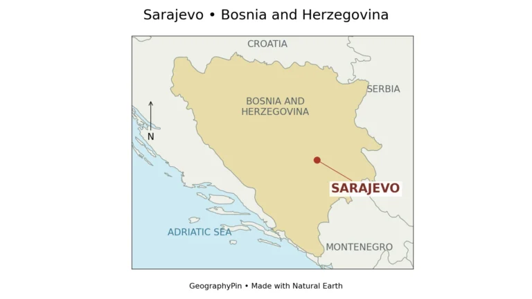
Bosnia and Herzegovina is one sovereign country in southeastern Europe, bordered by Croatia, Serbia and Montenegro. Sarajevo is its capital. The Dinaric mountain system dominates much of the interior, while northern river plains face the Sava and the south includes karst landscapes and a short Adriatic coastline at Neum. Its rivers drain toward both the Black Sea and the Adriatic.
How to use this article: Start with the Adriatic coast, compare the main landscapes, or untangle the entities and Brčko District.
1. Locate Bosnia and Herzegovina and its coast
Croatia wraps around much of the country’s northern, western and southwestern margins. Serbia lies to the east and Montenegro to the southeast. The country belongs to the western part of the Balkan Peninsula, but it has its own distinctive combination of inland valleys and a very limited coastal frontage.
Yes, the country has an Adriatic coast
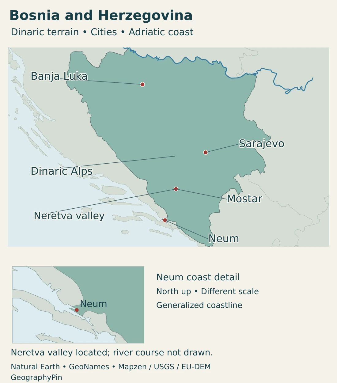
Neum provides Bosnia and Herzegovina’s opening to the Adriatic. It is a short stretch of coast rather than a long seaboard comparable with Croatia’s. On a regional map, the narrow coastal sector is easy to overlook, especially when borders are drawn with thick lines.
The country is therefore not landlocked. Its short coastline does not, however, make every inland river an Adriatic river. Much of the interior belongs to a different drainage system.
The Balkan countries map places these neighboring states in the wider peninsula. The map here focuses on Bosnia and Herzegovina’s own cities, relief and river connections.
2. Country facts, population and names
| Fact | Value | Date or meaning |
|---|---|---|
| Capital | Sarajevo | State capital, distinct from entity and local institutions. |
| Population | Approximately 3.402 million | BHAS mid-2025 estimate, published in 2026; based on the 2013 census. |
| Reported total surface area | About 19,772 square miles (51,209.2 km²) | BHAS reports 51,197 km² of land and 12.2 km² of sea. |
| Official languages | Bosnian, Croatian and Serbian | As listed by the Council of Ministers; language and ethnic identity are distinct concepts. |
| Currency | Convertible mark (BAM; locally KM) | A national currency linked to the euro under a currency-board arrangement. |
| Constitutional structure | Two entities and self-governing Brčko District | One sovereign state; the Federation contains ten cantons. |
| State institutions | Three-member Presidency, Parliamentary Assembly and Council of Ministers | Responsibilities are distributed across state and lower levels. |
The population is the national statistical agency’s mid-2025 estimate, not a new census enumeration or a count made in 2026. The source publishes the value in thousands. International population models can give different estimates, so their figures should not be silently combined with this national series.
Bosnia and Herzegovina are not the two entities
Bosnia and Herzegovina are historical and geographic regional names within the country. They are not the names of its two constitutional entities. Herzegovina is broadly associated with the south, while Bosnia covers the larger northern and central setting, but their geographic distinction is not a substitute for a current administrative map.
The Federation of Bosnia and Herzegovina is one entity within the state. Its name can be confusing because it contains the country’s full name, but “the Federation” and the entire country are not interchangeable. Republika Srpska is the other entity; it is not the neighboring Republic of Serbia.
3. Dinaric mountains, valleys and karst fields
Compare the main landscapes
| Setting | Terrain and position | Why it matters |
|---|---|---|
| Northern plains | Lower ground along the Sava and its tributaries. | Connects river corridors, settlements and agricultural land. |
| Dinaric interior | Mountain chains separated by valleys and basins. | Makes routes through valleys and across passes important. |
| Karst fields and uplands | Limestone landscapes with enclosed depressions, springs and underground drainage. | Surface relief alone does not reveal every water connection. |
| Herzegovinian river corridors | Southern valleys including the Neretva setting. | Links inland mountains with the Adriatic drainage system. |
| Neum coast | A small coastal sector on the Adriatic. | Gives the country direct sea access despite its predominantly inland geography. |
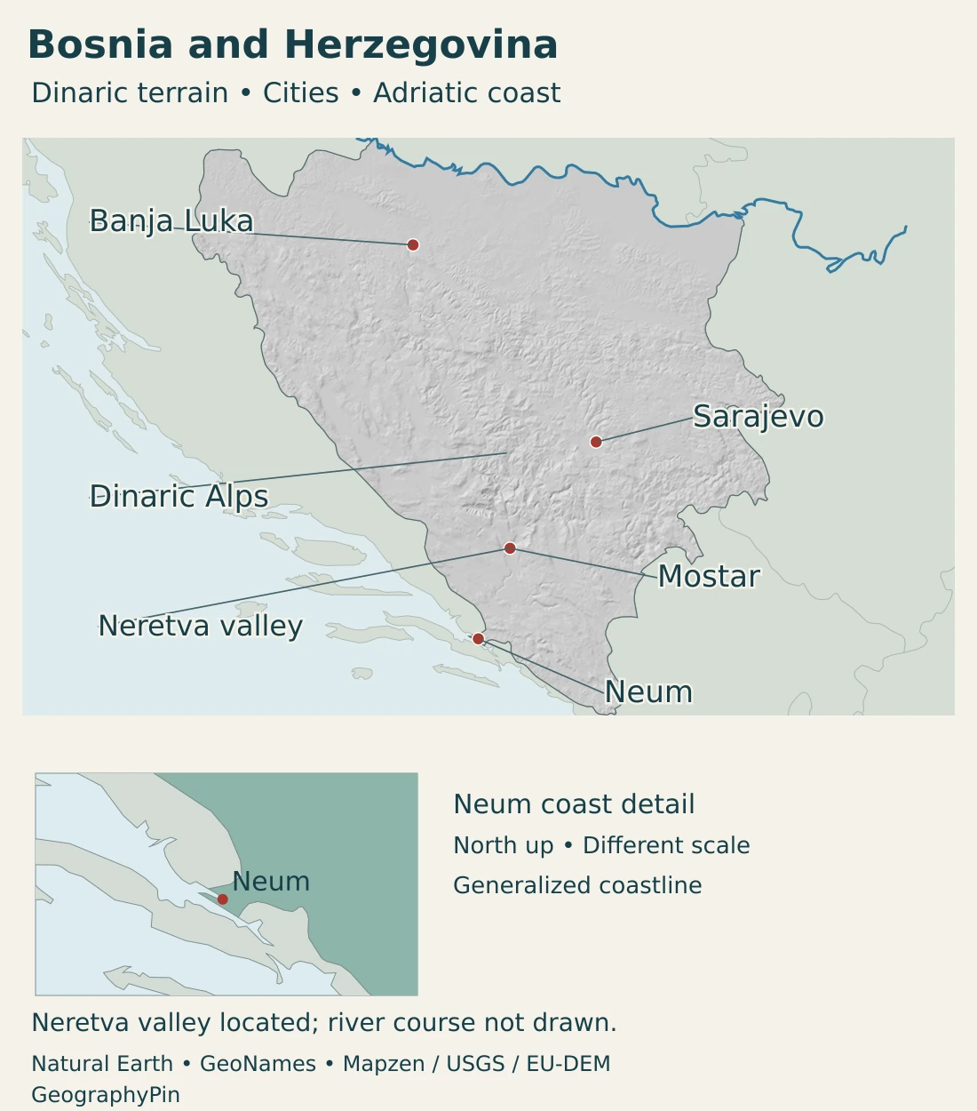
The Dinaric mountain framework trends broadly northwest–southeast. It is not a single continuous wall: valleys and lower basins interrupt the uplands, creating many different local settings. The northern lowlands contrast with the more rugged interior.
Karst is not simply a dry, empty landscape
In limestone country, water can move through fissures and underground passages as well as along visible channels. A broad enclosed depression in such terrain is called a polje. These fields can support meadows, wetlands and settlements around their edges rather than resembling a uniform rocky plateau.
Livanjsko Polje in the southwest provides a concrete example. Its Ramsar wetland documentation describes springs, rivers that enter sinkholes, and seasonal flooding. The field’s appearance can change greatly between wetter and drier conditions; a flooded surface is not necessarily a permanent lake.
Buško reservoir is a different feature within that wider setting: it is a managed permanent water body. Distinguishing a reservoir from seasonally inundated ground helps explain why a single blue shape on a small map can conceal very different hydrology.
4. Climate and rivers flowing toward two seas
The north and many inland valleys have continental climatic influences, while higher terrain has mountain conditions. Lower southern areas have stronger Mediterranean influences. These broad patterns overlap because elevation, slope and exposure vary over short distances.
A description of Herzegovina as Mediterranean should not be read as a claim that all of its mountains have the same weather as the coast. Likewise, a national climate average cannot describe both a northern plain and an exposed upland.
The Sava system leads toward the Black Sea
The Una, Vrbas, Bosna and Drina are major components of the northern drainage network. Their waters reach the Sava, then the Danube and eventually the Black Sea. The Sava also forms a long stretch of the boundary with Croatia, so water management is inherently international.
The southern system includes the Neretva and Trebišnjica, whose drainage belongs to the Adriatic basin. This is the key distinction: the country has an Adriatic coast, but many of its rivers ultimately reach a different sea.
The Neretva connects mountains, towns and downstream wetlands
Mostar stands in the Neretva valley. The river continues downstream into Croatia before reaching the Adriatic. Its catchment therefore cannot be understood solely within Bosnia and Herzegovina’s political boundary.
Flood management must also consider more than the main river channel. The UN-supported flood-risk assessment identifies river flooding, intense rainfall, torrents and groundwater among the relevant mechanisms. In karst terrain, underground connections add another layer to the relationship between rainfall and surface water.
The maps provide geographic orientation, not current water levels, flood boundaries or navigation conditions. Selected source river lines and valley labels do not represent a complete drainage network.
5. Sarajevo, other cities and languages
Sarajevo is the state capital and an inland urban center. Its surrounding mountains and valley setting are a central part of its geography. Our dedicated Sarajevo geography and map explores that local setting in more detail.
Banja Luka, Mostar and Neum occupy different positions in the national landscape. Banja Luka is in the northwestern interior; Mostar is associated with the Neretva valley in the south; Neum is coastal. Their locations are more informative than treating them as interchangeable dots on a country map.
Mostar’s river crossing and urban history
Mostar’s Old Bridge area illustrates how a river crossing can become central to a city’s identity. UNESCO describes the historic settlement in the Neretva valley and its layers of Ottoman, Mediterranean and later European architectural influence.
The Old Bridge was destroyed during the 1990s war and subsequently reconstructed. The World Heritage designation concerns the Old Bridge area, not every part of the modern city or the whole Neretva catchment.
Languages, citizenship and identity
The Council of Ministers lists Bosnian, Croatian and Serbian as official languages. The Constitution’s preamble names Bosniaks, Croats and Serbs as constituent peoples, alongside others and the country’s citizens. These categories concern people and constitutional arrangements; they do not divide every landscape into a single-language or single-identity territory.
“Bosnian” can describe a geographic or civic connection, while “Bosniak” names a particular people. These terms should not be treated as automatic equivalents. Individual identity is not determined simply by a person’s city, entity of residence or the language appearing on a map.
6. Government, transport and economic geography
Two entities and the special position of Brčko
The state consists of the Federation of Bosnia and Herzegovina and Republika Srpska. The Federation is subdivided into ten cantons. Brčko District has a special position: it is under the sovereignty of Bosnia and Herzegovina, its territory is held in condominium by the two entities, and it has its own institutions of local self-government. It is not a third entity or a separate sovereign state.
At state level, the constitutional framework includes a Parliamentary Assembly, a three-member Presidency and a Council of Ministers. The Presidency’s composition combines ethnic and entity-based rules: one Bosniak and one Croat member are elected from the Federation, and one Serb member from Republika Srpska. The Council of Ministers carries out state policies within its responsibilities and reports to the Parliamentary Assembly.
These arrangements are distinct from the geographic contrast between northern plains, mountain valleys and Herzegovina. An entity boundary is a constitutional division, not a mountain range or a river-basin boundary.
Mountain valleys shape major transport routes
Corridor Vc illustrates the relationship between terrain and infrastructure. EBRD’s project documentation describes the route through Bosnia and Herzegovina along the Bosna and Neretva valleys, connecting the northern and southern parts of the country.
A valley can offer a route through mountain country, but it is also a place where people live, farm and depend on water. Transport planning therefore involves environmental and community considerations as well as travel times. A route shown in project documentation is not a claim that every motorway section is already open.
Forests, processing and city-based activity
Forestry and wood processing provide a concrete link between landscape and economic activity. The Federation’s chamber of economy describes a chain extending from forest management to sawn timber, panels, veneer and finished wood products. These are different stages of production, not simply the export of unprocessed trees.
Such activity also depends on skills, equipment and access to markets. Forest resources alone do not explain where a finished product is designed, manufactured or sold. The chamber’s sector description applies to the Federation and should not be mistaken for a complete national production census.
Urban services and cultural heritage add other economic roles. Mostar’s reconstructed historic area, Sarajevo’s capital functions and the country’s transport corridors show how human geography is layered onto the physical landscape. Mountains influence opportunities and constraints, but they do not determine a city’s identity or political status.
Frequently Asked Questions
Does Bosnia and Herzegovina have a coastline?
Yes. The country reaches the Adriatic Sea at Neum. The coastal sector is short and can be difficult to distinguish on a small regional map.
Are Bosnia and Herzegovina separate countries?
No. Bosnia and Herzegovina is one sovereign state. The geographic names Bosnia and Herzegovina are also not the names of its two constitutional entities.
Do all its rivers reach the Adriatic Sea?
No. The Sava system carries much of the country’s drainage toward the Danube and Black Sea, while the Neretva and other southern catchments belong to the Adriatic basin.
What Did We Learn Today?
Bosnia and Herzegovina combines Dinaric mountains, northern river plains, karst fields and a short Adriatic coastline. Its drainage reaches two seas. Geographic regions, river basins and constitutional entities are different ways of dividing the same country and should not be confused with one another.
Sources & Data Notes
Sources, dates and map conventions
Population follows BHAS’s mid-2025 national estimate, reported in thousands and published in 2026. It is not a current census count. The surface-area figure follows the same publication’s stated land and sea components, without inferring a separate inland-water measure or a new boundary survey. Unit conversions are rounded. Historical environmental reports support stable geography, not current water levels or economic totals.
- Agency for Statistics, Demography 2025, published 2026: Table 9: mid-2025 population estimate in thousands, based on the 2013 census. General data report total surface area, with land and sea components.
- Council of Ministers, country information: Capital, official-language listing, entity structure, Federation cantons and the constitutional position of Brčko District.
- Constitution of Bosnia and Herzegovina, WIPO Lex: State continuity, constituent peoples and citizens, state institutions, three-member Presidency and Council of Ministers. Brčko’s later constitutional status follows the Council of Ministers source.
- University of Sarajevo, Department of Geography: Physical regions, Dinaric relief, historical geographic names and the country’s location. Historical demographic and economic figures are not current measurements.
- Bosnia and Herzegovina, Third Biennial Update Report, 2022: Stable geographic and climatic framework. Historical population projections, economic data and infrastructure totals are not used as current figures.
- Ramsar Information Sheet, Livanjsko Polje: Karst field, springs, sinkhole rivers, periodic flooding and the distinction from permanent Buško reservoir. Dated observations are not a current water-level survey.
- UNDP, climate-resilient flood-risk assessment, 2023: Sava and Adriatic catchments, named river systems and different mechanisms of flooding.
- UNESCO, Old Bridge Area of the Old City of Mostar: Neretva valley setting, historic urban layers, destruction and reconstruction of the Old Bridge, and the scope of the World Heritage property.
- EBRD, Corridor Vc compliance review: Bosna and Neretva valley alignment and environmental and community considerations. A planned alignment is not evidence that every section is operational.
- Chamber of Economy of the Federation, forestry and wood industry: Qualitative description of forest management and successive processing stages, not current national output or employment totals.
- Central Bank of Bosnia and Herzegovina, monetary policy: Convertible mark and its currency-board relationship with the euro; the country’s own currency is distinct from the euro.
Map sources and scope: Original GeographyPin maps use public-domain Natural Earth boundaries, populated-place coordinates, rivers and lakes. The complete source national outline is retained. Internal entity, district, canton and historical-region boundaries are not drawn. Country and coastal outlines are generalized, not an official boundary or maritime survey.
Sarajevo, Banja Luka and Mostar use Natural Earth city-coordinate attributes. Neum uses the GeoNames populated-place record, rather than an inland municipal centroid. GeoNames data are licensed under Creative Commons Attribution 4.0. The framed coastal inset is north-up and at a separate scale.
The Dinaric Alps label is a broad mountain locator. Neretva valley is marked near Mostar using the documented valley setting; the source river dataset lacks the Neretva, so no river course is invented. Selected actual source rivers and lakes do not represent a complete water network, current levels or navigation channels.
Hillshade is calculated from genuine elevations accessed through Mapzen Terrain Tiles, with no vertical exaggeration. Global elevation data courtesy of the U.S. Geological Survey. Produced using Copernicus data and information funded by the European Union – EU-DEM layers. Elevation-source attribution and terms apply. Shading is not bathymetry or numerical elevation bands.
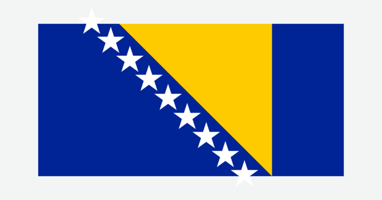
The cover uses national flag artwork from Commons. The intact flag retains its 2:1 proportions and is shown separately from the decorative outline motif.