Slovakia’s mountains are its most recognizable landscape, but they are only part of the country. Broad lowlands, enclosed basins and river corridors connect its cities and agricultural districts. Understanding those contrasts also helps place Bratislava, a capital at the country’s southwestern edge rather than near its center.
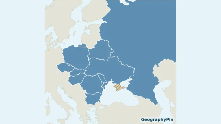
Slovakia is an independent, landlocked country in Central Europe, bordered by Austria, Czechia, Poland, Ukraine and Hungary. Bratislava is its capital. Carpathian ranges dominate much of the north and center, while lowlands open across the south and east. Slovakia is not Slovenia: the two are separate countries with different capitals and histories.
How to use this article: Resolve the name confusion, compare mountains and lowlands, or follow rivers toward two different seas.
1. Locate Slovakia, not Slovenia
Slovakia occupies an inland position between the Czech lands, the Polish side of the Carpathians, western Ukraine and the Hungarian lowlands. Austria touches its southwestern side. Its borders encompass both rugged mountain country and much lower terrain; there is no national coastline.
Two similar names, two separate countries
Slovakia’s capital is Bratislava; Slovenia’s is Ljubljana. Slovakia became an independent state on January 1, 1993, following the dissolution of Czechoslovakia. Slovenia emerged from Yugoslavia and lies farther southwest, where Alpine, Dinaric and Adriatic settings meet.
Slovakia is landlocked, while Slovenia has an Adriatic coast. Neither is a region of the other. The similarity of their English names does not indicate a shared modern government or a common national border.
The Europe country map places both states in context, while our European countries and capitals guide pairs each with its own capital.
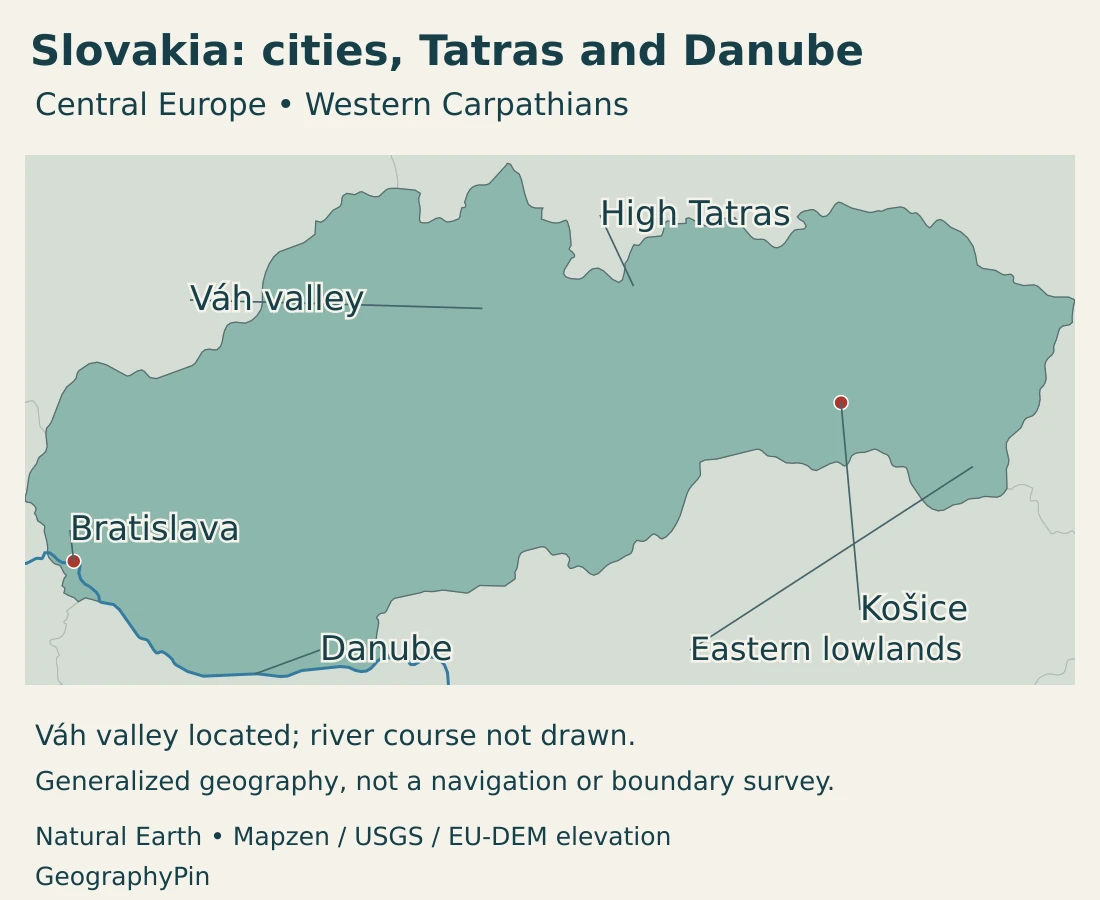
Bratislava at the southwestern edge
Bratislava lies on the Danube near Austria and Hungary. The Little Carpathians meet the surrounding lowland landscape here, making the capital a place where different physical settings converge.
Its border position helps explain its close connections with neighboring countries. It also means that a journey eastward across Slovakia encounters a succession of valleys, basins and mountain barriers rather than a country arranged evenly around a centrally located capital.
2. Country facts with dates and scope
| Measure | Value | Date or definition |
|---|---|---|
| Capital | Bratislava | Constitutional capital of the Slovak Republic. |
| Population | 5,403,009 | Provisional population at June 30, 2026, reported by the Statistical Office. |
| Area | About 18,932 sq mi (49,035 km²) | Geographical size published in the EU country profile. |
| State language | Slovak | Minority-language rights and use in official communication are governed by law. |
| Currency | Euro (EUR) | Member of the euro area since 2009. |
| Government | Parliamentary republic | President as head of state; prime minister heads the government. |
| Regional structure | 8 regions | Regional units are distinct from mountain ranges and drainage basins. |
The population is a dated provisional stock, not a new census count or a count of citizens alone. A figure for Bratislava city would also differ from one for the surrounding Bratislava Region. National, regional and municipal totals should not be interchanged.
The area figure is the published geographical size of the state. It is not a measurement of the Carpathians, which continue beyond Slovakia, or of the Danube basin, which covers parts of many countries.
3. Carpathian mountains, basins and lowlands
A landscape comparison
| Setting | What the landscape is like | Geographic significance |
|---|---|---|
| Northern Carpathians and High Tatras | High ridges, steep valleys and glacially shaped mountain terrain along the Polish border. | Strong elevation contrasts; mountain habitats and recreation differ from the lowlands. |
| Central ranges and interior basins | Mountain blocks separated by valleys and lower enclosed basins. | Settlement and transport follow the spaces between ranges rather than a uniform plain. |
| Danubian lowland in the southwest | Broad lower terrain adjoining the Danube and its tributaries. | Important agricultural country, with access to the capital and international river corridor. |
| Eastern Slovak lowland | Lower, more open country in the southeast, linked to the Bodrog–Tisza drainage system. | Contrasts with the mountains to the north and connects southward with the wider lowland basin. |
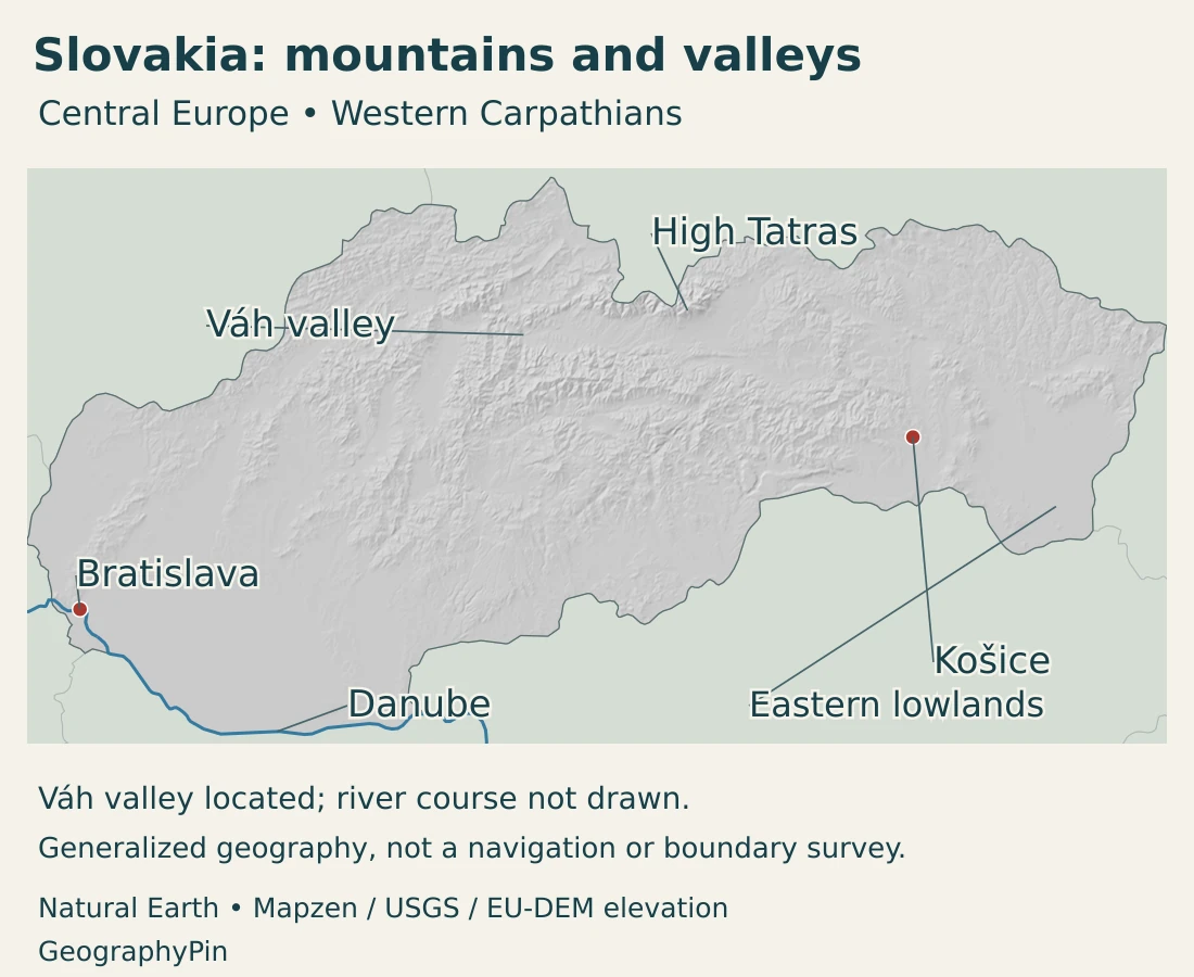
The Carpathians are a multinational mountain system, not another name for Slovakia. Within the country, the High Tatras are a particularly elevated and rugged part of that system. They do not occupy the entire north, and the Low Tatras are a separate range rather than simply the lower slopes of the High Tatras.
The Tatra landscape retains clear evidence of former glaciation. Glacial valleys and small mountain lakes, or tarns, distinguish it from the broad river floodplains below. The mountain system crosses the Slovak–Polish border, with protected areas on both sides.
Central Slovakia is more varied than a single continuous wall of peaks. Basins and valleys interrupt the uplands, creating usable land and routes between higher areas. On a relief map, these lower passages are as important for understanding the country as its highest ridges.
Limestone landscapes beneath the surface
In the Slovak Karst, water has dissolved limestone to produce caves, shafts and underground passages. Some caves were shaped by flowing streams; others reflect water moving slowly through fractures and cavities. The result is a landscape whose drainage cannot be understood from surface rivers alone.
The Caves of Aggtelek Karst and Slovak Karst form a transboundary UNESCO property shared with Hungary. The Baradla–Domica system is a concrete example of a cave network crossing a political border. A national boundary divides jurisdictions, not the underlying rock or every natural water pathway.
4. Climate and rivers across a European divide
Slovakia lies in the northern temperate zone and has four seasons, but its climate varies substantially with elevation and relief. Atlantic air brings moisture from the west; continental air can bring larger temperature contrasts. Mountains modify those influences locally.
The southern lowlands are generally warmer and drier than the higher mountains. The Tatras are much colder and wetter, with snow conditions very different from those around the Danube. A national seasonal average would hide those differences.
Enclosed basins add another complication. During temperature inversions, cold air can remain near a basin floor while air above is warmer. Elevation alone therefore does not predict the temperature at every location on every day. Exposure to prevailing winds and the orientation of slopes also affect local conditions.
Most water reaches the Black Sea, but not all
Most of Slovakia drains into the Danube system and ultimately the Black Sea. A smaller northern area belongs to the Vistula system, which reaches the Baltic Sea. The Poprad and Dunajec are the important northern exceptions to a simple “all rivers flow to the Danube” description.
The Váh is a major internal river corridor, descending through northern and western Slovakia before joining the Danube. Other tributary systems connect the central and eastern landscapes to the wider Danube basin. The eastern lowlands reach that basin through rivers associated with the Bodrog and Tisza.
The Danube River map shows the larger international route. In Slovakia, the river connects Bratislava with neighboring countries and carries water gathered far beyond the national boundary. The length of the whole Danube should not be confused with its Slovak reach.
River valleys are both connections and managed environments. Hydropower development, reservoirs and other engineering have altered parts of the network. A blue line on a national map identifies a river’s location; it does not show every dam, navigation condition or floodplain restriction.
5. Cities, settlement and languages
Slovakia’s settlement pattern reflects its mixture of lowlands, basins and mountain corridors. Bratislava anchors the southwest, Košice is an important eastern center, and cities such as Žilina occupy inland transport and industrial settings. These places are not all situated on the Danube or in one continuous metropolitan area.
Mountain landscapes can contain busy towns and industrial valleys as well as protected habitats. Conversely, the lowlands include agricultural land and smaller settlements, not only cities. The contrast between “mountain” and “lowland” is useful, but it is not a complete description of how people live.
Slovak and minority-language rights
Slovak is the state language. The Constitution also provides for minority rights, including education and official communication in minority languages under the conditions established by law. This is different from declaring every minority language nationally co-official.
Language, nationality and place of residence are different categories. The use of Slovak in state institutions does not imply that every household uses only Slovak or that a population total measures one ethnic group.
Regional names also need context. A region named after Bratislava or Košice extends beyond the city itself. The High Tatras and the eastern lowlands are physical settings, while the eight regions form an administrative layer. Neither set of boundaries automatically follows a river catchment.
6. Government and economic geography
Slovakia is a parliamentary republic. The president is head of state, while the prime minister heads the government. Regional self-government operates within the state; the regions are not separate sovereign countries.
The country’s European connections are visible in its institutions and its economic geography. It belongs to the European Union and uses the euro. Those arrangements support cross-border relationships, but they do not erase differences between the capital region, industrial corridors and more remote mountain districts.
Manufacturing has a regional pattern
Automotive manufacturing provides a clear example. The Slovak investment agency’s sector material identifies established production centers around Bratislava, Trnava, Žilina and Nitra. Plants and suppliers form an interconnected industrial network rather than an activity spread evenly across every municipality.
The northeast and southeast have their own economic histories. Košice has a long association with steelmaking, while wood processing has been important in parts of central Slovakia. Physical geography helps explain access to routes and resources, but investment, skills and historical development also shape industrial location.
Farming, forests and recreation
The southern and eastern lowlands provide important agricultural settings. In mountain areas, forests, grazing traditions and tourism have different relationships with the terrain. The Tatra protected-area landscape illustrates the need to accommodate recreation without treating every mountain valley as interchangeable development land.
Slovakia’s geography is therefore best read through connections between contrasting places: upland water flowing toward lowland rivers, settlements occupying basins and valleys, and industries linked to international markets. The national outline is compact, but the landscapes inside it are far from uniform.
Frequently Asked Questions
Is Slovakia the same country as Slovenia?
No. Slovakia is a landlocked Central European state with Bratislava as its capital. Slovenia is a separate country farther southwest, with Ljubljana as its capital and a short Adriatic coast.
What are Slovakia’s main physical regions?
Carpathian mountain ranges and interior basins occupy much of the north and center. The Danubian lowland lies in the southwest, while the eastern Slovak lowland opens toward the southeast.
Do all Slovak rivers drain into the Black Sea?
No. Most belong to the Danube system and reach the Black Sea, but the Poprad and Dunajec connect a smaller northern area to the Vistula and the Baltic Sea.
What Did We Learn Today?
Slovakia combines Carpathian mountains with interior basins and southern and eastern lowlands. Bratislava occupies a southwestern Danube setting, not the country’s center. Most rivers reach the Black Sea, with a smaller northern connection to the Baltic. Its landscapes, administrative regions and industrial corridors are different geographic layers, and the country remains entirely distinct from Slovenia.
Sources & Data Notes
Population is the provisional national stock at June 30, 2026, not a census result. The geographical-size figure follows the EU country profile’s reporting convention. Rounded conversions are for orientation; no population density is calculated from a differently defined area.
- Statistical Office, population on June 30, 2026: Provisional population of 5,403,009; released August 31, 2026.
- European Union, Slovakia country profile: Published geographical size of 49,035 km², capital, parliamentary institutions, euro and eight regions. The area is not presented as a separately measured dry-land total.
- Slov-Lex, Constitution of the Slovak Republic: Current consolidated text effective November 1, 2025; Articles 6, 10 and 34 support state language, capital and minority-language rights.
- Slovakia Travel, national geography: State formation date, neighboring countries and the mountain–lowland contrast.
- Government of Slovenia, country background: Separate Slovenian identity and the Alpine, Dinaric and Adriatic setting.
- Slovakia Travel, Bratislava region: Southwestern capital position, Little Carpathians and Danubian lowland.
- State Nature Conservancy, Tatry Biosphere Reserve: Shared Slovak–Polish mountain setting, former glaciation, tarns and traditional land uses.
- Slovak Caves Administration, World Natural Heritage: Limestone dissolution, stream caves and the diversity of karst forms.
- UNESCO, Aggtelek and Slovak Karst: Transboundary cave property and the Baradla–Domica system.
- Slovak Hydrometeorological Institute, climate: Atlantic and continental influences, relief, exposure and regional climate contrasts.
- Slovak Geological Survey, climatic-geographic types: Lowland, basin and mountain climate types, including basin inversions.
- European Commission, Slovakia river-basin assessment, 2025: Danube and Vistula basin districts, lowland agriculture and hydromorphological changes associated with river engineering.
- Slovak Hydrometeorological Institute, monitoring network 2025: Danube and Vistula drainage districts and their component catchments.
- Slovakia Travel, Komárno: Confluence of the Váh and Danube.
- Slovakia Travel, Lower Zemplín: Eastern Slovak lowland and the Bodrog setting.
- Vojtek, fluvial flood risk in Slovakia, 2023: National study-area description and the Poprad–Dunajec exception to Black Sea drainage.
- SARIO, Automotive Sector in Slovakia, January 2025: Established manufacturing locations and supplier geography; source publication date applies to the industrial overview.
- SARIO, regional analyses: Qualitative context for automotive clusters, eastern steelmaking and central wood processing.
Map sources and scope: Original GeographyPin maps use public-domain Natural Earth country boundaries, populated-place coordinate attributes, rivers and lakes. The complete Slovakia source outline is retained. Boundaries are generalized, not an official boundary survey.
Bratislava and Košice use the source city coordinates. The High Tatras and eastern lowlands are broad landscape labels, not administrative or physical-region boundaries. The Danube follows the source records named Donau and Danube. The Váh is absent from the selected river layer, so its course is not invented: the map instead locates the valley near Ružomberok using the official Váh water-route locality. The eastern lowland reference uses the official Latorica locality. Source lake shapes are retained across borders, not clipped into artificial national fragments. Water features are not current measurements or navigation channels.
Hillshade is calculated from genuine elevations accessed through Mapzen Terrain Tiles, with no vertical exaggeration. Global elevation data courtesy of the U.S. Geological Survey. Produced using Copernicus data and information funded by the European Union – EU-DEM layers. Elevation-source attribution and terms apply. Shading is not bathymetry or a set of numerical elevation bands.
The cover uses Slovakia’s national flag artwork from Commons. The intact flag retains its 3:2 proportions and appears separately from the decorative outline motif.