Camelback Mountain brings a striking desert skyline into the middle of metropolitan Phoenix. Its familiar profile is easy to recognize, but the name alone tells little about the rocks, the elevation or the difficulty of its trails. Reading the mountain means separating those three things: where it stands, what it is made of and how people reach it.
Camelback Mountain is a desert mountain in the Phoenix area of Arizona, with a summit listed at 2,704 feet (about 824 meters) above sea level. Its lower western head and higher hump include contrasting sedimentary and granitic rocks. It is a rocky urban landmark, not the similarly named Pennsylvania resort.
1. Where is Camelback Mountain?
Camelback stands northeast of central Phoenix, near Scottsdale and Paradise Valley, in Maricopa County. The locator below places its summit alongside selected nearby communities. This is a metropolitan setting: the mountain is not an isolated destination far beyond the city, even though its slopes contrast sharply with the surrounding built landscape.
Locate the Arizona mountain
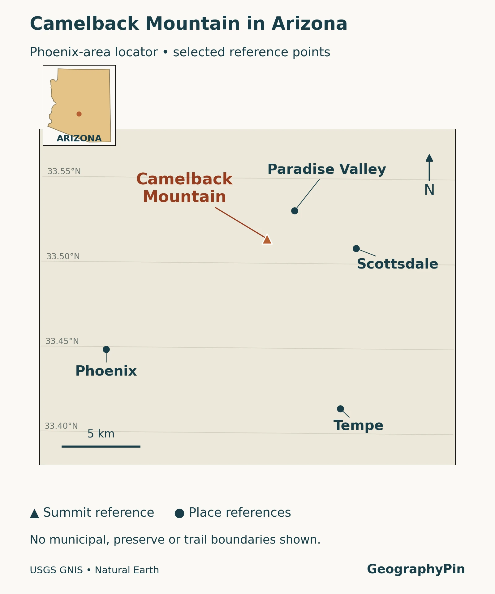
Read the triangle as a summit reference, not the center of a municipal district. The named dots are geographic place references rather than outlines of the cities they represent. A location diagram can establish which mountain is meant without pretending to show property lines, access points or a navigable trail.
That distinction matters when searching for directions. A map pin labeled Camelback Mountain may point to the summit, while an official trailhead is a different place. The City of Phoenix maintains separate information for Echo Canyon and Cholla. Use those access pages rather than attempting to reach the summit coordinate directly.
2. Rocks behind the camelback shape
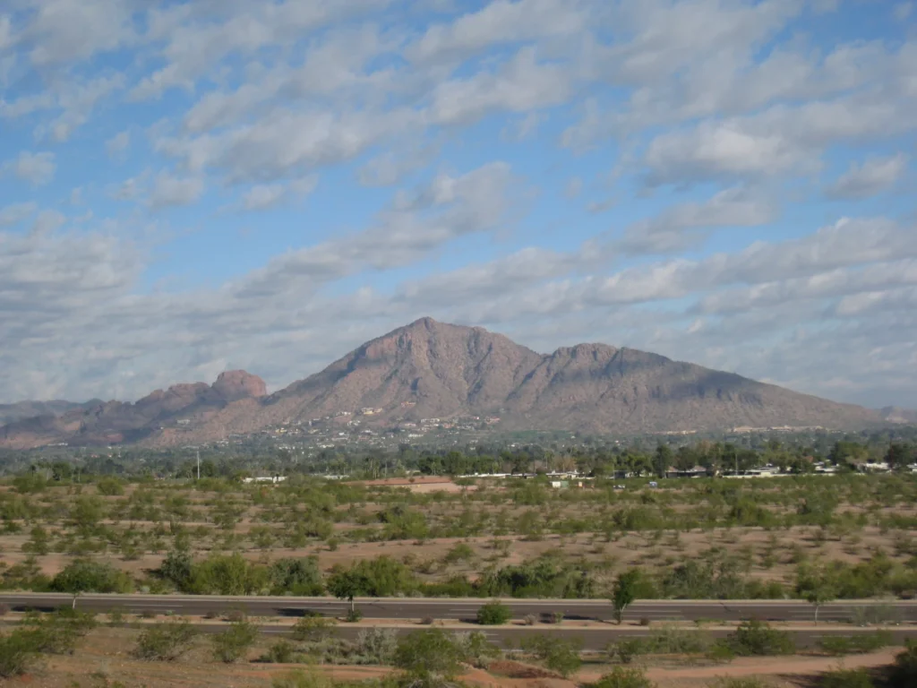
The head and hump are not one uniform rock mass
The Arizona Geological Survey describes Camelback as an erosional remnant of a fault block tilted during crustal extension. Much of the mountain consists of Proterozoic granite. On its southwestern side are considerably younger sedimentary breccia and other clastic rocks. The contact is generally a fault, not simply an untouched stack of younger layers resting on older granite.
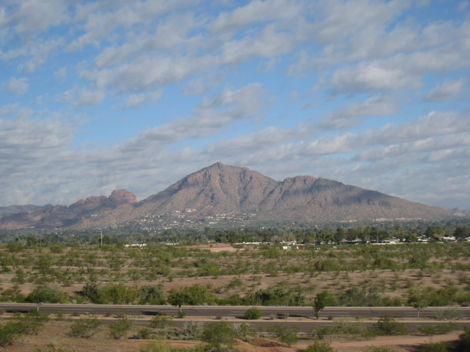
- Western head: the lower reddish rock mass on the left belongs to the mountain’s younger sedimentary-rock sector, including sedimentary breccia and other clastic rocks.
- Main hump: the higher central mass is dominated by much older Proterozoic granite.
The numbers identify broad landform sectors, not mapped geological contacts. Interpretation follows the Arizona Geological Survey’s description; color alone is not a rock-identification test. View from Papago Park, photographed 25 January 2009. Photo: Dru Bloomfield / Wikimedia Commons, CC BY 2.0. Resized and converted to WebP; HTML annotations added by GeographyPin.
Breccia is a rock containing angular fragments held within finer material or mineral cement. “Sedimentary” identifies how this particular kind formed; the word breccia alone does not prove that a rock is volcanic. “Clastic” means made from fragments of pre-existing rock. Those terms describe material and texture, not the outline of a mountain.
A rock’s age and a mountain’s present shape answer different questions. Ancient granite can become part of a much later landform through movement, exposure and erosion. For the broader distinction between rock formation and mountain building, see what a mountain is.
3. A mountain in the Sonoran Desert
Camelback belongs to a regional landscape of desert basins and intervening uplands. The National Park Service describes the Southern Basin and Range as alternating mountains and broad valley floors; the Sonoran Desert occupies part of that wider region. A mountain surrounded by a city still sits within this physical landscape.
Desert does not mean a uniform flat surface
The contrast between a rocky mountain and nearby low ground illustrates why a desert map cannot be read as a map of sand alone. Relief, slopes, exposed rock and valleys are part of desert geography. The NPS also describes the Sonoran region as ecologically varied, with conditions changing across elevations and terrain. Regional descriptions should not be mistaken for a plant inventory of one trail.
Here, urban geography and physical geography meet in the same view. Buildings help locate the mountain within a metropolitan area; its slopes and rock exposures tell a different story. Neither a city label nor a desert label by itself explains the landform.
4. Official trails and heat conditions
The city identifies two summit routes: Echo Canyon on the western side and Cholla on the eastern side. Both are classified Extremely Difficult. Their position within metropolitan Phoenix does not turn them into ordinary urban walks. This article is geographic context, not a route guide or a statement that either trail is currently open.
Check the city’s Echo Canyon and Cholla pages for current access instructions, restrictions and notices. Trailhead access is separate from the summit location shown on our map.
Under the city’s heat policy checked in November 2026, Echo Canyon and Cholla are restricted from 8 a.m. to 5 p.m. on days when the National Weather Service issues an Extreme Heat Warning. This is a warning-triggered restriction, not a claim that the trails close on that schedule every day. Nor does it establish that hiking outside those hours is safe.
Consult the official heat-safety page and current weather before making plans. A photograph taken in January, a familiar skyline or an apparently short route cannot establish conditions for a future visit.
5. Key facts and measurement notes
| Item | Geographic meaning |
|---|---|
| Location | Phoenix metropolitan area, Maricopa County, Arizona, United States. |
| Summit elevation | 2,704 feet (about 824 meters) above sea level, as listed by the City of Phoenix. |
| Regional setting | Sonoran Desert within the wider Basin and Range landscape. |
| Main rock contrast | Older granite and younger sedimentary rocks; not a uniform sandstone mountain. |
| Official summit routes | Echo Canyon and Cholla; current access information belongs on the city trail pages. |
Summit elevation is not the amount climbed. Elevation measures height relative to a reference level. A trail’s elevation change concerns a route, while the difference between its lowest and highest points is its vertical range. These values need not be interchangeable, and none is a measure of horizontal distance.
The city map and trail webpages also give slightly different Echo Canyon distance figures. Rather than combine them into a falsely precise itinerary, use the current official route information for planning. The rounded metric summit conversion above does not imply that the height was newly surveyed for this article.
What Did We Learn Today?
Camelback Mountain is an Arizona desert landform within metropolitan Phoenix. Its recognizable profile combines contrasting rock sectors, while its summit elevation describes height above sea level rather than a trail’s climb. A locator map, geological interpretation and current city access notice each answer a different question; none substitutes for the others.
Sources & Data Notes
The locator uses USGS GNIS reference points and Natural Earth regional outlines. It does not show trail routes, preserve boundaries or mapped geological contacts. Photo markers identify broad visible sectors. Trail policy was checked in November 2026 and can change. The summit figure is the city’s published value, not a new survey.
- Arizona Geological Survey, Fieldnotes, Fall 1987: Stephen J. Reynolds, “Geologic Highlights of the Phoenix Region,” for the feature-specific geology.
- USGS: sedimentary breccia, terminology.
- National Park Service: Southern Basin and Range and Sonoran Desert ecosystems, regional context rather than a site-specific biological inventory.
- City of Phoenix: Cholla, Echo Canyon and official mountain map, elevation and route context.
- City of Phoenix: heat safety, conditional closure policy.
- USGS GNIS and Natural Earth public-domain data, locator sources.
- Photo: Dru Bloomfield / Wikimedia Commons, CC BY 2.0; photographed from Papago Park on 25 January 2009, resized and converted to WebP. HTML markers added by GeographyPin.