Rocky Mountain National Park concentrates several mountain landscapes within a relatively small part of the Rockies: broad meadow valleys, forested slopes, glacial basins and exposed alpine ridges. Its name can make the park sound like the whole mountain system. The more useful starting point is its actual Colorado boundary and the Continental Divide running through it.
Rocky Mountain National Park protects a high-elevation part of the southern Rocky Mountains in north-central Colorado. The Continental Divide separates its western Colorado River headwaters from eastern drainage toward the Mississippi system. Forests, meadows and alpine tundra vary with elevation and exposure; the park boundary is not the boundary of the Rocky Mountains.
How to use this article: Distinguish park, range and meadow, interpret the terrain transect, or compare named elevation measurements.
1. Locate the park between its eastern and western gateways
The park lies in northern Colorado, west of Estes Park and east of Grand Lake. It includes land in Boulder, Grand and Larimer counties. Those places locate a particular protected area, not the full extent of the Rocky Mountains, which continue far beyond Colorado and beyond the United States.
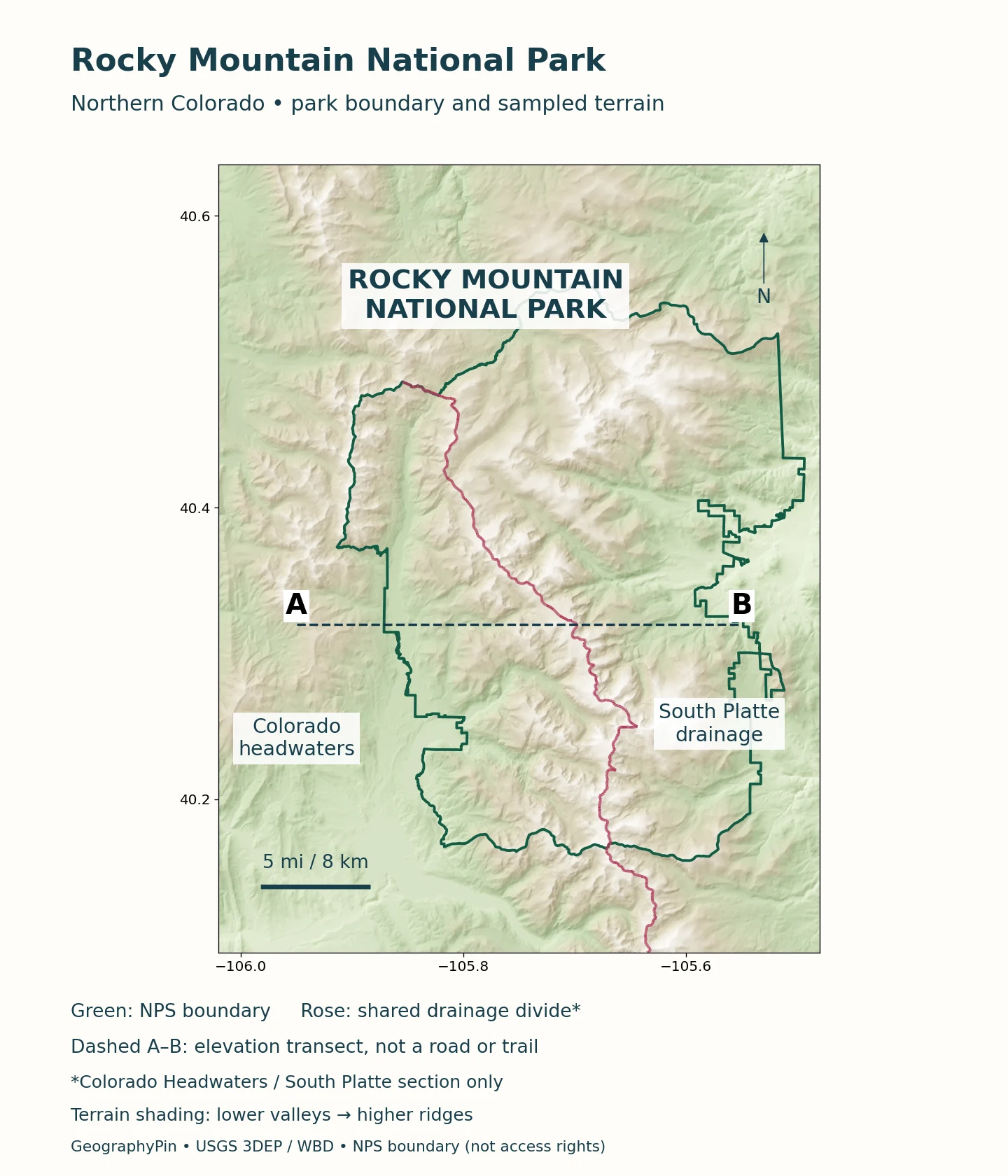
Park, range and meadow are different meanings
Rocky Mountain National Park is an administrative and conservation unit. The Rocky Mountains are a much larger mountain system. Within the park, names such as Moraine Park and Horseshoe Park use “park” in another sense: an open mountain valley or meadow rather than a separate national park. Estes Park is also the name of a gateway town.
The National Park Service reports approximately 415 square miles (1,076 square kilometers) within the park’s gross boundary. That gross extent includes inholdings; a boundary line should not be treated as proof that every parcel inside is publicly accessible. The locator is for geographic orientation, not a substitute for current park maps, property information or signed trails.
Grand Lake and Estes Park sit on opposite sides of the mountain crossing. Trail Ridge Road links them when through travel is available, but the road is not an all-season connection. The distance between two points on a small map can therefore be a poor guide to the journey available on a particular day.
2. Follow the Continental Divide and the headwaters
The Continental Divide follows a winding course through the park rather than a straight north–south line. It separates natural drainage basins. On the western side, streams contribute to the Colorado River system. On the eastern side, streams belong to the Mississippi drainage, including waters connected through the Big Thompson and Cache la Poudre systems.
A divide is a boundary between drainage directions, not necessarily a single continuous knife-edge ridge. It can pass through saddles and across high ground of different shapes. Trail Ridge Road crosses it at Milner Pass; the road’s highest point is elsewhere. Crossing the divide and reaching the road’s maximum elevation are two different geographic events.
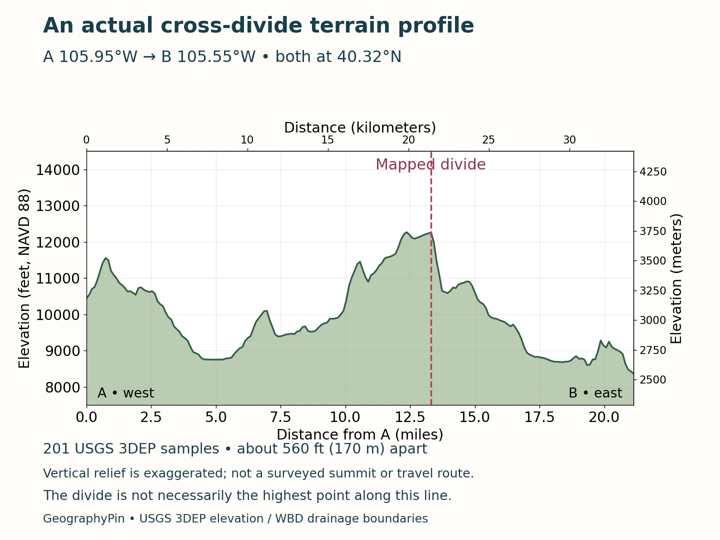
A terrain profile is not a travel route
The transect shows elevation along the line marked on the locator. Its horizontal distance follows that sampling line, not the distance along a winding road or trail. It is useful for comparing the height and relief of the landscape, but it does not describe a safe crossing or establish a surveyed summit elevation.
Natural drainage also differs from managed water movement. The Bureau of Reclamation describes the Alva B. Adams Tunnel carrying water from Colorado’s western slope to the eastern slope, where it enters East Portal near the park boundary southwest of Estes Park. Such transfers cross the natural drainage divide. The map’s basin orientation should not be read as a claim that every drop follows an uninterrupted route to its natural downstream ocean.
3. Separate the age of the rocks from the shape of the valleys
The park’s rocks and its present landforms tell stories at different timescales. Ancient crystalline rocks form much of the mountain core. The National Park Service describes metamorphic rocks around 1.8 billion years old and major granite intrusions around 1.4 billion years old. Those ages do not mean that the modern peaks have stood at their present heights for that long.
Mountain uplift, erosion and later glaciation changed the landscape. The NPS geodiversity account relates major Rocky Mountain uplift to the Laramide mountain-building episode around 70 million years ago. It also identifies younger volcanic rocks in the Never Summer Mountains, formed roughly 29–23 million years ago. The western mountains are therefore not simply an identical continuation of every rock type seen farther east.
Ice subsequently reshaped valleys and basins. Glaciers widened and deepened valleys, leaving U-shaped cross-sections, steep cirques and accumulations of transported debris called moraines. Chasm Lake below Longs Peak occupies a cirque; Moraine Park preserves landforms associated with former valley ice. Glacial carving helps explain the scenery without implying that glaciers created the entire mountain range.
Not every surface was carved in the same way. Rounded uplands, steep glacial walls and lower meadow valleys can occur near one another. Looking for those contrasts is more informative than treating every exposed rock or ridge as the product of a single geological event.
4. Read the transition from forest to alpine tundra
Elevation influences temperature, snow and growing conditions, but it does not create perfectly horizontal ecological stripes. NPS descriptions distinguish montane, subalpine and alpine environments. Forest composition and openness change as conditions become colder and more exposed, while local slopes and shelter modify the transition.
The alpine tundra generally begins around 11,000–11,500 feet (3,350–3,505 meters), depending on exposure. This treeline transition is an ecotone, not a fence. Low-growing plants can survive above the trees by staying close to the ground, where they are less exposed to wind. Their small size is an adaptation, not evidence that the environment is biologically empty.
| Environment | Approximate setting | Scope and limitation |
|---|---|---|
| Montane | Lower meadow and forest zone; up to about 9,500 ft (2,900 m) | NPS regional descriptions extend below the park; this is not its minimum elevation |
| Subalpine | About 9,000–11,000 ft (2,745–3,350 m) | Broad transition overlapping the upper montane zone |
| Alpine tundra | Treeline generally around 11,000–11,500 ft (3,350–3,505 m) | Exposure changes the transition; not a fixed horizontal border |
The overlapping ranges are intentional. A sheltered slope and a windswept ridge at similar elevations need not support the same vegetation. The table describes broad NPS ecological zones rather than a remotely mapped habitat boundary or a promise about the plants at one exact coordinate.
Alpine tundra is also not interchangeable with Arctic tundra. Both can be treeless and cold, but one occurs at high elevation and the other at high latitude. NPS notes that permanently frozen ground is much less extensive in the park than it is across many Arctic tundra areas. A treeless mountain summit alone does not prove continuous permafrost beneath it.
5. Compare a summit, a pass and a road high point correctly
Longs Peak is the park’s highest summit, reported by the current NPS statistics page at 14,259 feet (4,346 meters). That is a mountain elevation, not the altitude of the usual visitor routes. Trail Ridge Road reaches 12,183 feet (3,713 meters), while Milner Pass, where the road crosses the Continental Divide, is lower.
| Feature | Elevation | What the figure means |
|---|---|---|
| Longs Peak summit | 14,259 ft (4,346 m) | Published summit elevation on NPS park statistics page |
| Trail Ridge Road high point | 12,183 ft (3,713 m) | Road maximum, not the Continental Divide crossing |
| Milner Pass | About 10,760 ft (3,280 m) | Rounded pass elevation; NPS pages differ by 1 ft |
Keep the measured object attached to the number
A pass is a low crossing on a ridge or divide; a road high point is the maximum along that road; a summit is the top of a named mountain. Their elevations answer different questions. A terrain raster also averages or samples a surface at finite resolution and need not reproduce a narrow summit’s published elevation exactly.
The table compares named features. Metric values are rounded conversions of the stated feet, not new surveys.
6. Let current conditions determine access
The geography explains why access changes. Trail Ridge Road rises above treeline and is exposed to wind, snow and rapidly changing conditions. It provides a through connection between the eastern and western gateways during its open season, but its presence on a map does not guarantee through travel. Check the current NPS road page and recorded status before relying on the crossing.
Bear Lake Road serves a different corridor on the eastern side. Old Fall River Road is another distinct route, not simply a second name for Trail Ridge Road. These routes have different surfaces, operating arrangements and seasonal restrictions. Use the park’s current route information rather than transferring a rule from one road to another.
Timed-entry requirements and access arrangements can change by season and corridor. The NPS timed-entry page is the appropriate place to check the rules for the date and area you intend to visit. This geography profile does not turn one season’s reservation hours into a permanent rule.
Stay on designated alpine trails: repeated trampling harms low vegetation and exposes thin soils. The profile is not a shortcut across tundra.
What Did We Learn Today?
Rocky Mountain National Park is a protected part of the much larger Rockies, with a winding drainage divide, glacially shaped valleys and ecological transitions from forest to alpine tundra. Summit elevations, pass elevations and road high points describe different features. Accurate map reading keeps those distinctions together with the limits of terrain data and the changing conditions that govern access.
Sources & Data Notes
Elevation comparisons identify named features rather than selecting among conflicting published park minimums. Milner Pass is rounded to about 10,760 feet (3,280 meters): NPS pages differ by one foot, and the statistics page’s paired metric value is inconsistent with its stated feet. Ecological zones are approximate transitions, not mapped borders. Access and reservation details remain subject to current NPS guidance.
Maps use the official NPS gross boundary and USGS 3DEP terrain. The highlighted drainage boundary is only the shared edge of USGS WBD HUC4 Colorado Headwaters (1401) and South Platte (1019), not the full Continental Divide. The profile uses 201 bilinearly interpolated elevation samples from 1-meter source products, spaced about 560 feet (170 meters) along a 21.1-mile (34-kilometer) line at 40.32° N. Heights reference NAVD 88; contributing surveys have different acquisition dates. Vertical relief is exaggerated about 7.4 times. The line extends beyond the park and is not a route or summit survey.
- National Park Service: Rocky Mountain park statistics
- NPS: Natural features and ecosystems
- NPS: Alpine tundra ecosystem
- NPS: Official brochure and geographic description
- NPS: Geodiversity Atlas, Rocky Mountain National Park
- NPS: Geologic activity
- NPS: Hydrologic activity
- Bureau of Reclamation: East Portal Diversion Dam
- NPS: Current park roads information
- NPS: Current timed-entry information
- USGS 3DEP elevation service and source catalog
- USGS Watershed Boundary Dataset: HUC4
- NPS Land Resources Division boundary data
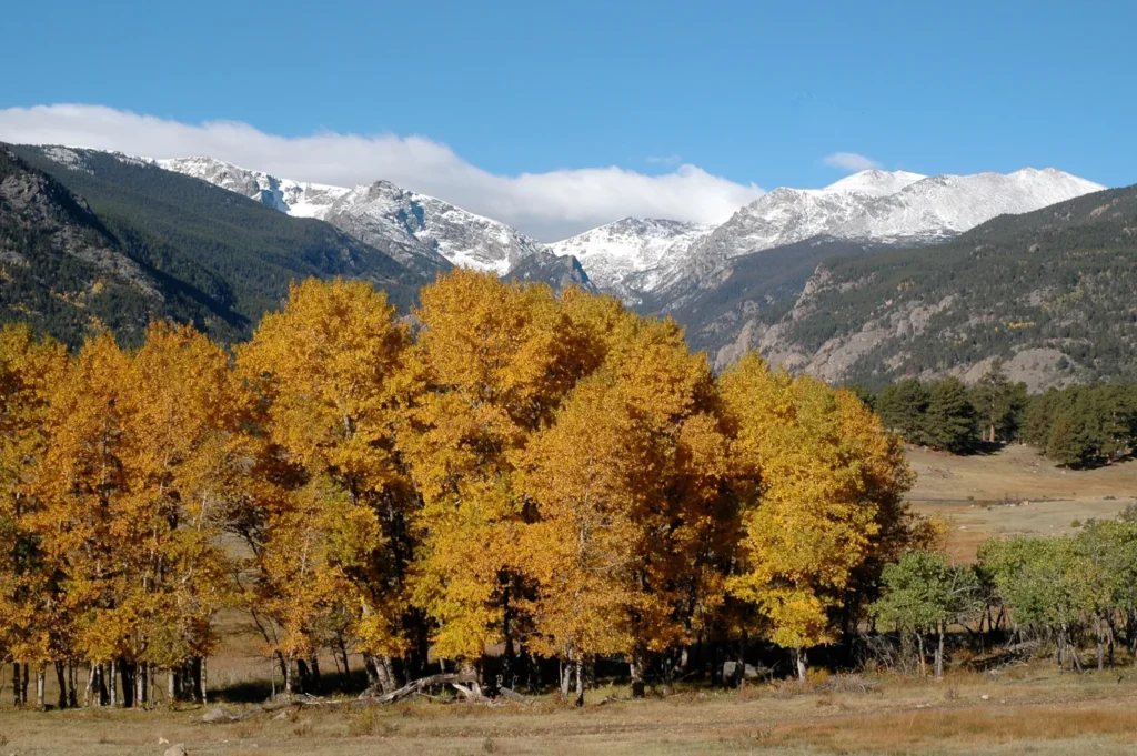
Featured image: Moraine Park, NPS/Jim Ecklund, from the NPS natural features page. Resized and converted to WebP. No claim to original U.S. Government works.