Lake Lanier’s long coves and wooded peninsulas can look like a natural lake landscape. They are also a map of flooded river valleys. To understand this reservoir, start with its two major river arms, Buford Dam and the water that continues downstream. Recreation is part of the picture, but water storage and river management explain why the lake is here.
Lake Lanier, formally Lake Sidney Lanier, is a reservoir in Georgia, USA, northeast of Atlanta. Buford Dam impounds the Chattahoochee River, while the Chestatee forms another major arm. The lake supports several water-management purposes, including water supply and hydropower. Its reported area and depth depend on the water level used as the reference.
1. Where is Lake Lanier?
Locate the rivers before the recreation areas
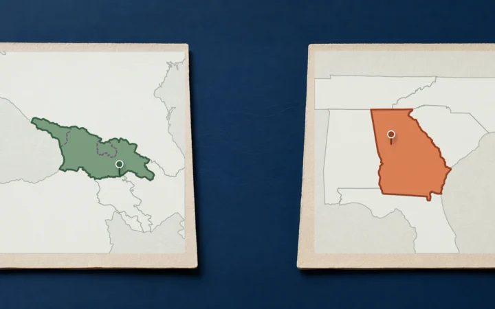
The lake occupies parts of Hall, Lumpkin, Dawson, Forsyth and Gwinnett counties in north-central Georgia. This is the U.S. state, not the country in the Caucasus. Gainesville is a useful nearby geographic reference; Atlanta lies downstream and southwest of the reservoir rather than on its shore.
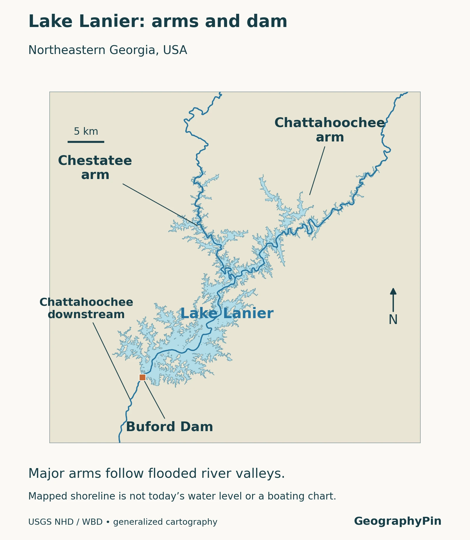
The Chattahoochee and Chestatee arms follow the drowned valleys of those rivers. Smaller tributary valleys create the branching coves between peninsulas. This shape matters when reading a map: two points that appear close across a cove can be far apart by road, and a narrow arm is not a separate lake merely because it has its own local name.
Buford Dam is at the reservoir’s downstream end. Beyond it, the Chattahoochee continues toward metropolitan Atlanta. The local map distinguishes the lake, its principal arms and the dam; the wider basin view below shows where that water ultimately goes. Neither is a chart for navigating individual channels or locating underwater hazards.
2. What do the size and depth figures mean?
Read each number with its pool elevation
A reservoir does not have one unchanging surface area. As its level rises or falls, shallow margins and tributary coves change extent. The Corps’ master-plan figures below describe the full conservation pool at a specified elevation, not today’s shoreline.
| Measure | Reference value | How to interpret it |
|---|---|---|
| Surface area | 38,425 acres, about 60 sq mi (155.5 km²) | Area at a pool elevation of 1,071 ft NGVD29 |
| Maximum depth | 160 ft (48.8 m) | Maximum at that reference pool; not average depth |
| Shoreline length | 692 miles (about 1,114 km) | Includes the branching shoreline at the reference level, not a straight-line length |
| Reference surface elevation | 1,071 ft (326.4 m), NGVD29 | Height relative to a named vertical datum, not depth |
| Water-body type | Freshwater reservoir | Impounded river water, not a natural glacial lake |
The long shoreline is a consequence of the many inlets and peninsulas. It should not be read as a distance across the reservoir or as the length of one continuous public walking route.
NGVD29 identifies the reference system used for elevation. Do not compare that number directly with a reading using a different datum without checking the conversion. Similarly, a water-surface elevation of 1,071 feet does not mean the reservoir is 1,071 feet deep.
The 2017 water-control manual lists seasonal top-of-conservation elevations of 1,071 feet in summer and 1,070 feet in winter. These are operating reference levels, not promises that the lake will remain exactly there. For an actual observation, use the timestamp, unit and datum shown with the USGS Lake Sidney Lanier near Buford monitoring record.
3. Buford Dam created a reservoir in stages
Construction, filling and completion are different dates
The Corps’ detailed project history places the start of reservoir filling on February 1, 1956. The overall project was essentially complete in June 1957, and the lake first reached its then-normal 1,070-foot pool in May 1959. These milestones explain why short accounts can attach different years to the lake’s creation: building a dam, beginning impoundment and filling a reservoir are not the same event.
The same history documents the acquisition of rights to more than 56,000 acres and the relocation of more than 700 families. This was a changed inhabited landscape, not an empty basin waiting for water. Those documented changes deserve attention in their own right, without substituting legends for the record of land acquisition and displacement.
A reservoir retains water behind a structure but remains connected to a river system. Water continues to arrive from upstream and leave through managed releases and other outflows. That distinction is useful when comparing Lanier with natural lakes: both are inland water bodies, but the origin and control of their outlets differ. See how lakes and reservoirs fit within inland-water geography.
4. Follow the Chattahoochee through the ACF basin
Lanier is upstream, not the whole watershed
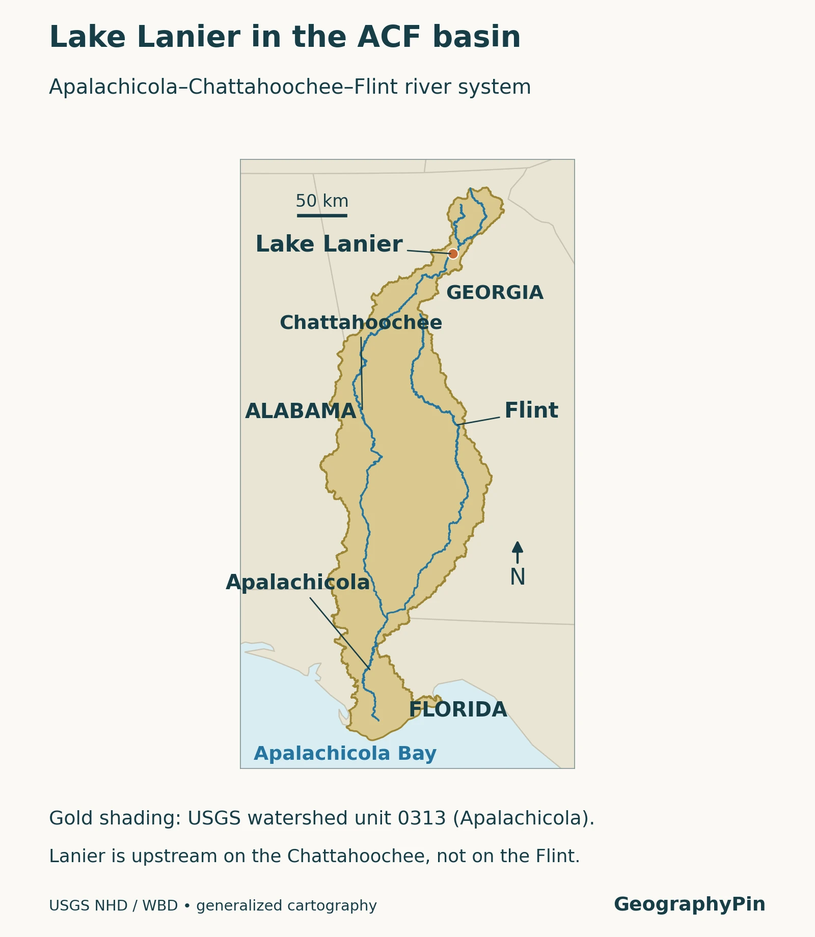
ACF stands for Apalachicola–Chattahoochee–Flint. Far downstream of Lanier, the Chattahoochee and Flint meet at Lake Seminole. The Apalachicola then flows through Florida toward Apalachicola Bay and the Gulf. The combined river system links parts of Georgia, Alabama and Florida.
The Flint is not a tributary entering Lake Lanier. Its role is farther downstream in the larger basin. This is why a local lake map and a regional watershed map need different scales: one explains the reservoir’s arms, while the other explains connections between major rivers and states.
A basin boundary identifies land draining toward an outlet; it is not a boundary around people who all obtain drinking water directly from the same lake. Downstream flow, local withdrawals, rainfall and tributaries interact across the system. A single reservoir is important within that network without being its only source of water.
5. Water supply is more than one intake
Direct withdrawals and downstream dependence
Georgia’s Environmental Protection Division identifies five providers permitted to withdraw surface water directly from Lake Lanier for municipal supply: Buford, Cumming, Forsyth County, Gainesville and Gwinnett County. Other communities depend on water released into the Chattahoochee downstream. Those are related but different ways of using stored water.
The state’s water-supply storage agreements concern allocation and accounting, not simply a pipe delivering the same daily quantity everywhere. Storage is a volume; withdrawal is water taken over a period; river flow is a rate. Keeping those terms separate prevents a storage figure in acre-feet from being mistaken for an annual supply total.
Hydropower, flood-risk management, recreation and environmental needs also shape the reservoir’s role. The trade-offs help explain why maximizing the lake level is not the only management objective. A high or low shoreline alone cannot reveal the full set of upstream and downstream conditions behind an operating decision.
6. Visiting the lake and the river below the dam
Choose the specific park, ramp or shoreline access point before making plans; “Lake Lanier” covers a large, irregular water body. Confirm current access, closures and facility information with the responsible operator rather than assuming all recreation sites share the same hours or rules.
Below Buford Dam, the Chattahoochee River National Recreation Area begins with the Bowmans Island Unit. The National Park Service warns that water can rise rapidly when the dam releases water. Conditions on a quiet-looking downstream reach can therefore change without a storm directly overhead. Check official river conditions and release information before entering or approaching the water.
The most useful distinction is between a geography reference and an operational update. This article explains the reservoir’s setting and function. Current lake levels, release schedules and access notices belong to the agencies monitoring or managing them, and should be checked for the day and location of a visit.
What Did We Learn Today?
Lake Lanier is a managed freshwater reservoir in Georgia, USA, not an isolated natural lake. Its branching shape follows river valleys, its measurements depend on the reference water level, and its role extends beyond recreation to water supply and the wider Chattahoochee system. Local lake conditions and downstream river conditions are related, but not interchangeable.
Sources & Data Notes
The fact table uses the October 2021 master-plan reference pool, not a current lake-level reading. Elevations retain the source datum, NGVD29; a monitoring record using another datum must not be compared without adjustment. The maps use generalized source geometry, not surveyed navigation or public-access boundaries.
- USACE, Lake Sidney Lanier and Buford Dam Project Master Plan, October 2021. Reference measurements and project setting.
- USACE, Buford water-control manual, March 2017. Construction and impoundment chronology, relocation record and seasonal operating references.
- Georgia EPD: Lake Lanier Water Supply Storage. Direct withdrawal providers and storage agreements.
- Northwest Florida Water Management District: Apalachicola River and Bay. Downstream river connections.
- National Park Service: Buford Dam. Recreation-area setting and warning about rapid rises below the dam.
- National Park Service: Chattahoochee current conditions. Operational information to check separately.
- USGS monitoring location 02334400. Timestamped water-level information.
- USGS National Hydrography. Source hydrography and Watershed Boundary Dataset for the original maps.
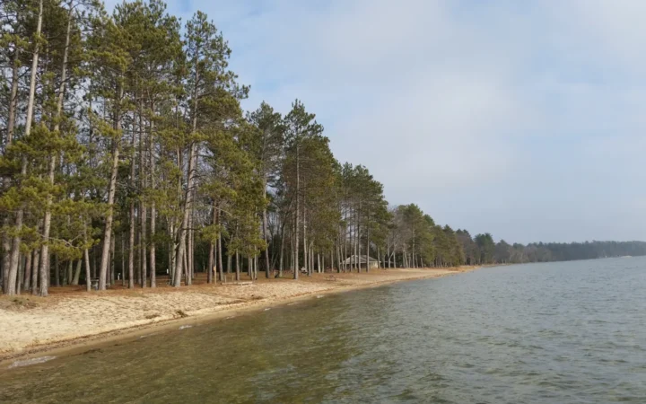
Featured photograph: Thomson200 / Wikimedia Commons, CC0. Lake Lanier from West Bank Park, July 2018; resized and converted to WebP.