Tokyo can mean a dense cityscape beside a bay, a prefecture-level territory stretching into mountain forests, or a much larger urban region crossing administrative borders. Its geography makes sense only when those meanings are separated. Even remote Pacific islands belong to Tokyo Metropolis, despite being far beyond the skyline.
Tokyo lies on the Pacific side of Honshū, at the southwestern edge of Japan’s Kantō Plain. Tokyo Metropolis includes the 23 special wards, the Tama area to their west, and the Izu and Ogasawara islands. Its mainland landscape rises from Tokyo Bay and river lowlands through uplands to western mountains, including Mount Kumotori.
Choose the right scale: Compare the wards and metropolis, locate Tokyo’s mountains, distinguish the major river routes, or interpret the dated population comparison.
1. Where is Tokyo?
Tokyo is in the southern Kantō region of eastern Honshū, Japan’s largest island. The central urban area faces the inner part of Tokyo Bay, with Chiba Prefecture across the eastern side of the bay and Kanagawa to the southwest. Saitama lies north of Tokyo’s mainland territory, while Yamanashi borders its mountainous west.
This location connects several contrasting landscapes. Tokyo Bay is a marine setting; the lowlands and uplands behind it form part of the Kantō region; farther west, the terrain becomes increasingly mountainous. An uninterrupted expanse of buildings can conceal those changes, but it does not remove them.
A photograph of Shinjuku or the waterfront therefore represents only one part of Tokyo. Neither the city’s most recognizable skyline nor the boundary of a railway map defines the full metropolitan territory.
2. The 23 wards and the wider metropolis
Administrative Tokyo is not the same as Greater Tokyo
Tokyo Metropolis is a prefecture-level local government. It contains 23 special wards, 26 cities, five towns and eight villages. The 23 wards occupy the eastern mainland urban core; they are not the entire metropolis.
| Component | What it includes |
|---|---|
| 23 special wards | The eastern mainland ward area, including central districts such as Shinjuku and Chiyoda. |
| Tama area | The mainland west of the wards: 26 cities, three towns and one village. |
| Island area | Izu and Ogasawara island jurisdictions: two towns and seven villages. |
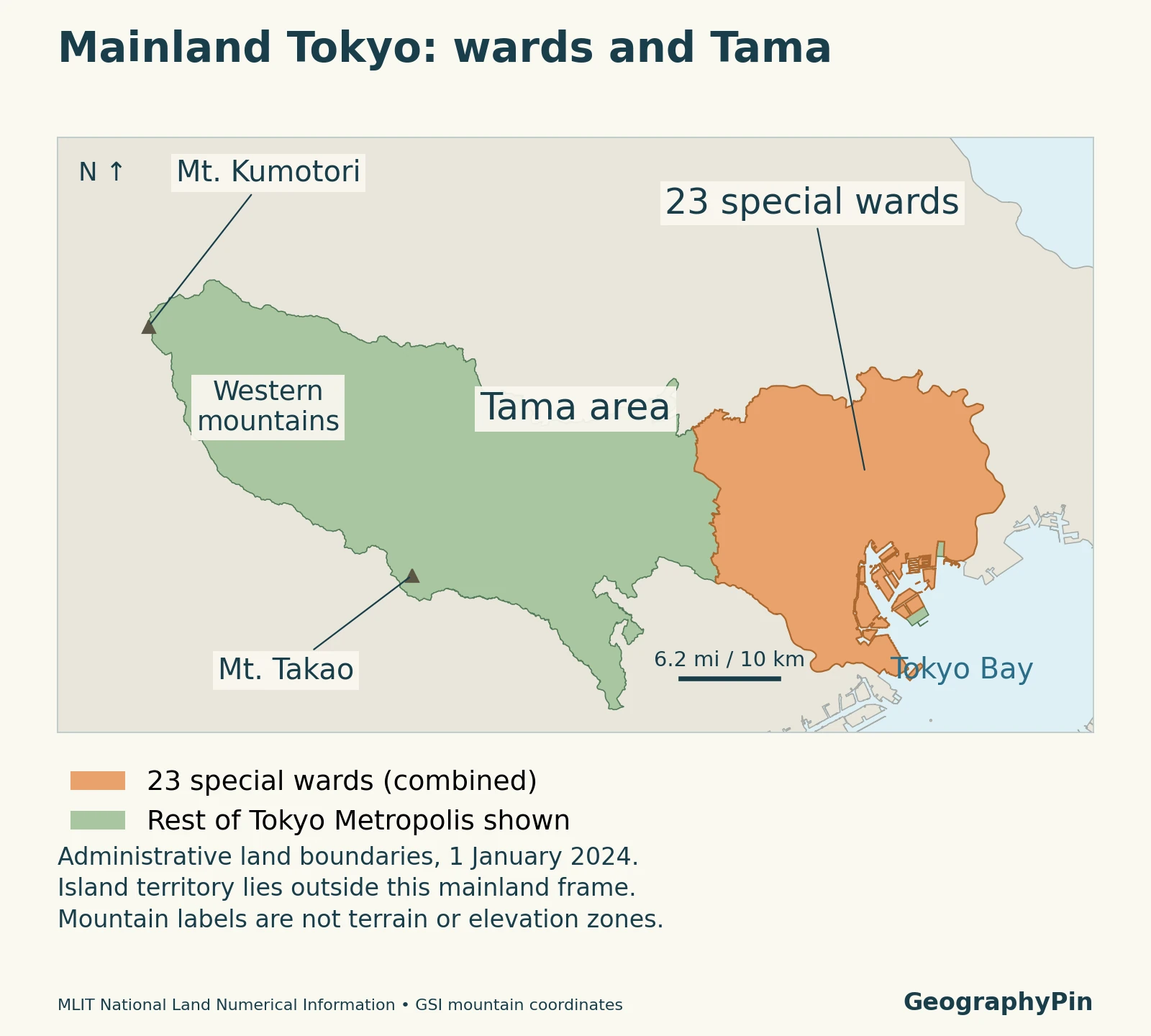
The Tama area includes both heavily developed communities and western mountains. It is not a synonym for wilderness. The metropolitan islands, meanwhile, are not extensions of the bayfront: the Ogasawara island groups lie far south in the Pacific.
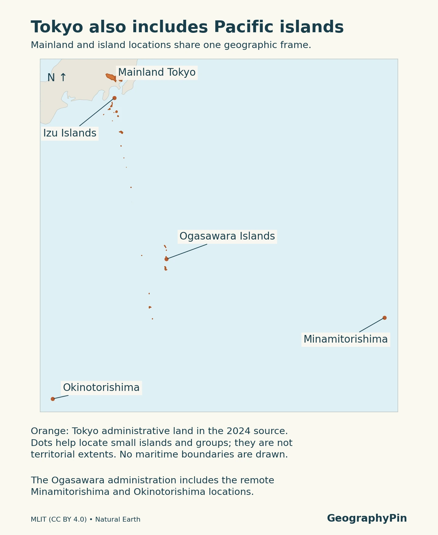
“Greater Tokyo” usually describes a broader urban or metropolitan region extending into neighboring prefectures. Its boundary depends on the statistical or planning definition being used. A figure for that wider region should not be presented as the population of Tokyo’s 23 wards or of Tokyo Metropolis.
The present metropolitan system also differs from the former Tokyo City. The city and prefecture were merged in 1943; the familiar 23-ward system dates from 1947. Calling the whole modern metropolis simply a single city can hide this administrative structure.
3. Kantō Plain, uplands and Tokyo Bay
The Kantō Plain is a broad regional landform, not a uniform tabletop. Geological Survey of Japan work distinguishes the Musashino Upland from the Tokyo Lowland and documents valleys cutting through the upland. Even within the built-up city, slopes and valley floors can change the local setting over short distances.
To the east, river lowlands approach Tokyo Bay. To the west, terraces and upland surfaces give way toward the hills and mountains of Tama. These physical transitions do not follow ward borders exactly, so an administrative map and a landform map answer different questions.
The subsurface adds another layer. Geological investigations identify buried valleys and sediments beneath parts of both the lowland and upland. An elevated neighborhood cannot automatically be treated as having identical ground conditions to every other elevated neighborhood, and a broad geography map is not a site-specific engineering assessment.
Tokyo Bay provides the coastal setting for ports, canals and waterfront districts. The bay extends beyond Tokyo’s administrative territory, with shores belonging to other prefectures. “Tokyo Bay” and “Tokyo Metropolis” are therefore not interchangeable areas, even though they share a name.
4. Mountains within Tokyo: Kumotori and Takao
Which mountain is actually in Tokyo?
Mount Kumotori reaches about 6,617 feet (2,017 meters) and is the highest mountain in Tokyo. Its summit lies where Tokyo, Saitama and Yamanashi meet, in the mountainous western setting of Okutama. It is not a peak hidden among the central wards.
Mount Takao, in Hachiōji, reaches about 1,965 feet (599 meters). It is a lower mountain in western Tokyo, not an alternative name for Kumotori. The two examples show why a search for “Tokyo mountain” can refer to very different elevations and distances from the city center.
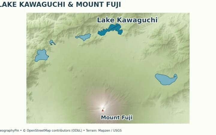
Mount Fuji is different again. It straddles Yamanashi and Shizuoka prefectures, outside Tokyo Metropolis. Seeing Fuji from a Tokyo viewpoint does not place it inside Tokyo’s boundary. The nearby Lake Kawaguchiko and Lake Yamanaka also belong to the Fuji-area geography of Yamanashi, not the Tokyo ward area.
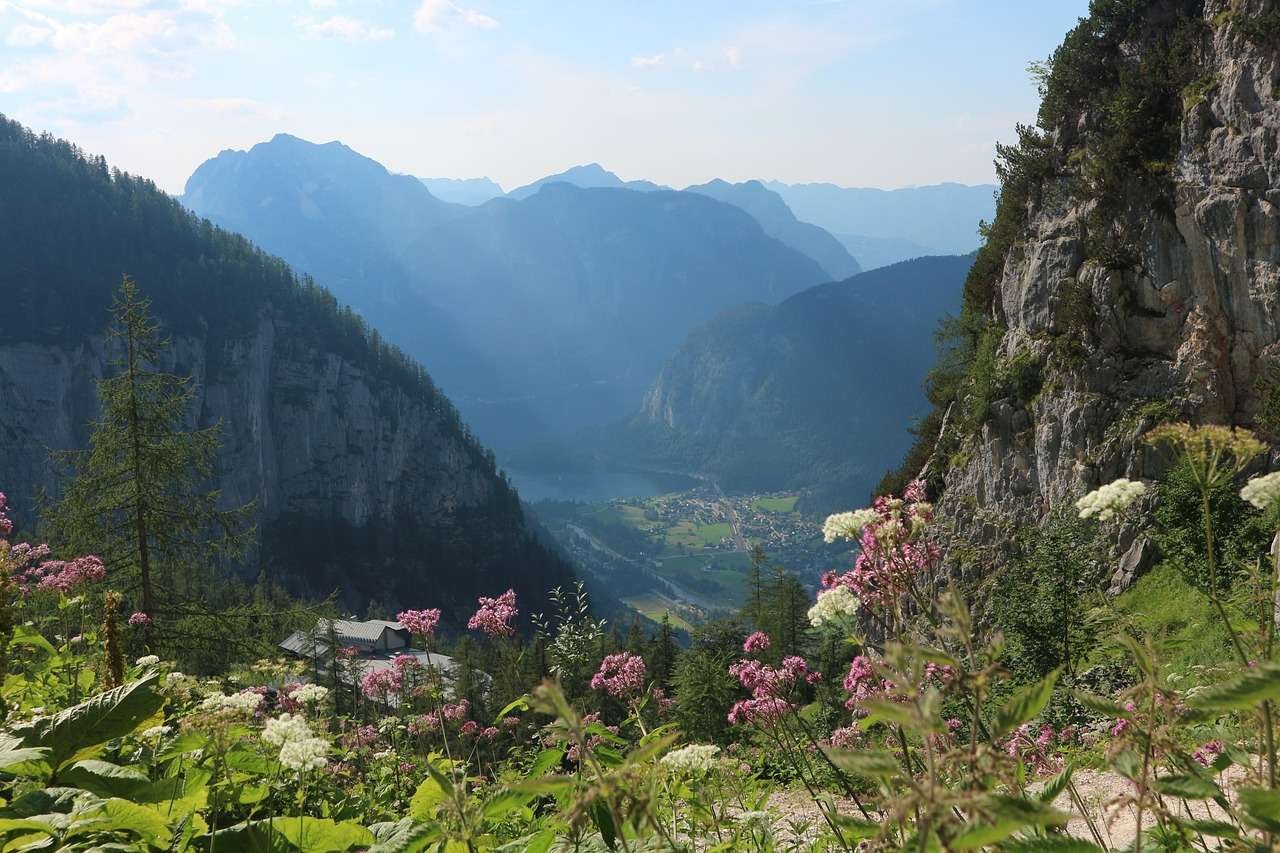
Forested slopes and river valleys in western Tokyo make an instructive contrast with the bayfront. Both fall within the same metropolitan government, but their terrain, settlement patterns and everyday landscapes differ substantially. This is a useful distinction between physical geography and administrative geography.
5. Rivers and the reclaimed shoreline
The Tama, Sumida and Arakawa are different routes
The Tama River begins in Yamanashi, crosses the western mountain setting and continues toward Tokyo Bay near Haneda. Along part of its lower course it separates Tokyo from Kanagawa. Its basin crosses prefectural boundaries, so the water system is larger than the part contained inside Tokyo.
The Sumida River runs through the eastern urban area to Tokyo Bay. Historically it formed the lower Arakawa route. After the construction of the Arakawa floodway, the new channel took the Arakawa name while the route downstream from Iwabuchi became known as the Sumida. Today they follow distinct channels through the urban area.
This history matters because Tokyo’s waterways are both natural systems and engineered landscapes. Floodways, embankments, gates and canals have changed how water moves through the lowlands. A straight channel on a modern map may reflect flood-control construction rather than an untouched ancient course.
The shoreline has changed too. Land reclamation around the Port of Tokyo has extended the coast and created artificial islands, using materials such as soil and dredged sediment as well as waste at designated sites. Reclaimed waterfront land is not the same landform as the Musashino Upland or a mountain valley.
Nor is all of Tokyo reclaimed. The distinction belongs to particular areas of the coast and their development histories. Comparing a modern shoreline with an older map can reveal changes that a present-day administrative outline alone cannot explain.
6. Population and geographic measurement
Use the same boundary and reference date
| Geographic unit | Estimated residents |
|---|---|
| Tokyo Metropolis, including Tama and islands | 14,288,867 |
| The 23 special wards only | 9,983,365 |
These figures come from the Tokyo Metropolitan Government’s October 29, 2026 release. They are estimates for October 1, based on the final 2025 census population and subsequent registered population changes. They are not a census count for 2026 or a total for Greater Tokyo.
The difference between the rows is geographic, not a disagreement about how many people live in one identical area. The larger total includes the municipalities of Tama and the metropolitan islands as well as the wards.
Frequently Asked Questions
Are the Izu Peninsula and Izu Islands the same place?
No. The Izu Peninsula is part of Shizuoka Prefecture on Honshū. The Izu Islands extend into the Pacific and belong to Tokyo. Their related names do not make them the same landform or administrative area.
What Did We Learn Today?
Tokyo is more than its 23 wards: the metropolis also contains Tama’s developed communities and mountains, plus Pacific island jurisdictions. Its mainland geography links Tokyo Bay, modified river lowlands, the Musashino Upland and western peaks. Kumotori is Tokyo’s highest mountain; Fuji is outside Tokyo. Accurate maps and statistics depend on keeping these physical features and administrative areas distinct.
Sources & Data Notes
Tokyo Metropolis, the 23 special wards and Greater Tokyo are different geographic units. The population table uses one official estimate release and reference date. Mountain elevations are rounded from the cited metropolitan-government sources; the maps are for geographic orientation, not navigation or parcel-boundary decisions.
Map method: The mainland map combines municipality codes 13101–13123 into one 23-ward area. Its green remainder includes Tokyo land not assigned to an individual municipality in the source. Maps use MLIT’s January 1, 2024 administrative dataset, derived from GSI mapping and reused under CC BY 4.0. These dated outlines are not a survey or a representation of every subsequent shoreline change. The island map uses a single geographic frame, with small-island reference dots rather than enlarged territorial outlines; its backdrop is public-domain Natural Earth data. Peak positions use GSI’s named-mountain coordinates.
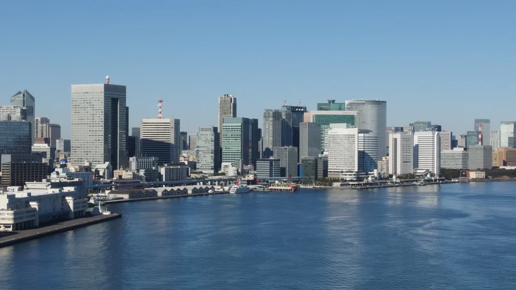
Featured photograph: Tokyo waterfront, Guilhem Vellut, December 29, 2013, CC BY 2.0; cropped, resized and converted for this page. The photograph records the waterfront in 2013, not today’s complete skyline.
- GO TOKYO: Izu Peninsula: The peninsula is in Shizuoka, distinct from Tokyo’s Izu Islands.
- Tokyo Metropolitan Government: administrative structure: The wards, cities, towns and villages.
- Tokyo Metropolitan Government: geography and history: Mainland and islands; metropolitan-system history.
- Tokyo population estimates, October 1, 2026: Dated totals and the final 2025 census basis.
- Geological Survey of Japan: central Tokyo: Musashino Upland, Tokyo Lowland and buried valleys.
- GSI: Tokyo terrain: Upland valleys and local relief.
- Tokyo natural parks: Okutama: Kumotori elevation and prefectural-border location.
- Tokyo natural parks: Takao: Takao elevation.
- Japan National Tourism Organization: Mount Fuji: Fuji in Yamanashi and Shizuoka.
- MLIT: Tama River: Source, prefectures and Tokyo Bay outlet.
- Tokyo Bureau of Construction: Sumida River: Relationship to the Arakawa and floodway.
- Tokyo Port: land reclamation: Reclaimed-land construction and history.