Honolulu’s shoreline skyline occupies only a small part of Oʻahu. Behind the coastal districts, valleys climb toward the Koʻolau Range; beyond them, the island continues to communities that are governed by Honolulu but are not part of its downtown. That difference is the key to reading a Honolulu map correctly.
Honolulu lies on the southern coast of Oʻahu in Hawaiʻi, between the Pacific Ocean and the Koʻolau mountain range. Urban Honolulu is a census-designated place, while the City and County of Honolulu covers Oʻahu and additional northwestern islands within the state. Its geography combines a coastal plain, steep valleys, harbor waters and younger volcanic cones.
Read the map with the right boundary: Compare the city and county meanings, follow the mountain-to-coast setting, distinguish the harbor and crater landmarks, or check the dated population figures.
1. Where is Honolulu?
Honolulu is the capital of the U.S. state of Hawaiʻi, on Oʻahu rather than on the island of Hawaiʻi, commonly called the Big Island. Its central waterfront faces the Pacific along the island’s southern shore. Waikīkī lies east of downtown Honolulu; the North Shore is a different part of Oʻahu, not a northern section of the same downtown.
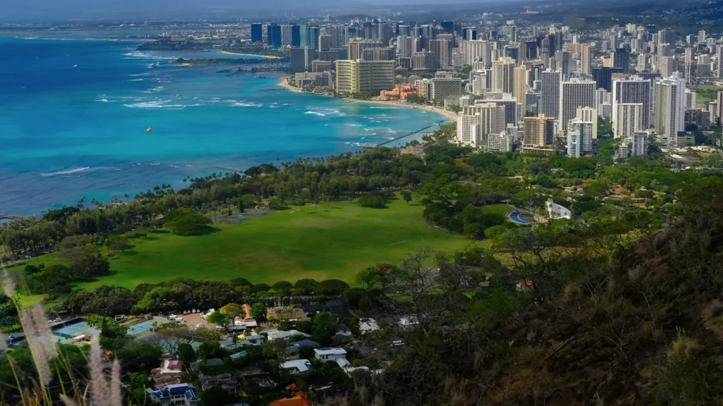
The surrounding ocean is not just a backdrop. It forms one side of a narrow urban setting, with rising terrain on the inland side. Looking at the city from offshore reveals a dense coastal strip backed by ridges, while looking inland from Waikīkī reveals how quickly flat land gives way to valley slopes.
Oʻahu is also different from the state of Hawaiʻi as a whole. A location described as “in Hawaii” may be on another island entirely. That matters when comparing a photograph or a weather report with the geography of Honolulu.
2. Honolulu city, statistical place and county
One name, different geographic meanings
“Honolulu” in everyday speech often means the south-shore city and its central neighborhoods. That is useful for orientation, but it does not supply a single precise boundary for statistics. Two official units need to be distinguished:
| Label | Meaning |
|---|---|
| Urban Honolulu CDP | A Census Bureau statistical place, not a separately incorporated city or a map of every built-up area. |
| City and County of Honolulu | The consolidated local government covering Oʻahu and other islands within its jurisdiction; much broader than downtown. |
The county includes the Northwestern Hawaiian Islands within the state, but not Midway Atoll, which is outside the state. An Oʻahu-only map therefore shows the main inhabited island portion of the county, not its entire geographic extent. County boundaries, census-place boundaries and the visible edge of buildings are three different things.
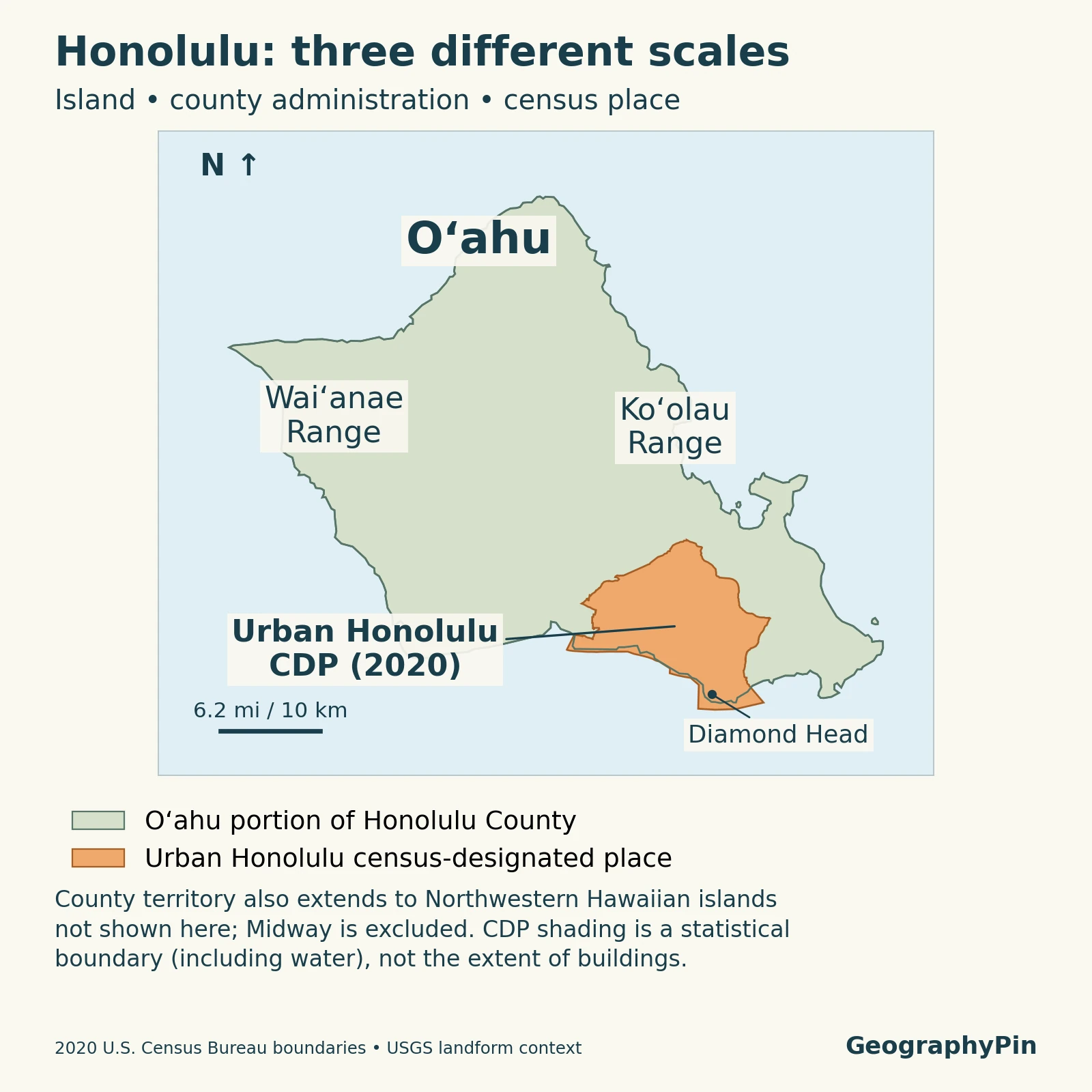
The highlighted statistical place on this map must not be read as a city-government boundary. Communities elsewhere on Oʻahu can be outside Urban Honolulu CDP while still being inside the City and County of Honolulu. Likewise, a metropolitan-area statistic should not be substituted for a CDP statistic just because both labels contain “Honolulu.”
3. Mountains, valleys and the coastal plain
From the Koʻolau slopes to the shore
Oʻahu’s two main mountain ranges, the Koʻolau in the east and Waiʻanae in the west, are eroded remnants of shield volcanoes. Honolulu’s immediate mountain backdrop is the Koʻolau side, not the Waiʻanae Range across the island. The ridges visible from the city are therefore parts of a much older volcanic landscape shaped by erosion.
Valleys such as Mānoa and Pālolo extend inland from the coastal urban area. Their floors, side slopes and intervening ridges create a very different setting from the broad waterfront districts. A map that shows only a shoreline and a dot for Honolulu misses much of the geography that organizes its neighborhoods.
The coastal plain provides relatively level ground, but it is not equally wide everywhere. Development also extends up valleys and onto slopes, so “coastal city” does not mean that every neighborhood is flat or at sea level. Local elevation and drainage matter more than a single average elevation assigned to the city.
This is a useful example of physical geography: volcanic foundations, erosion, water and coastlines help explain the shape of settlement without being identical to administrative boundaries. The county government can cover the island, while the landforms continue to divide it into very different local settings.
4. Honolulu Harbor and volcanic landmarks
Honolulu Harbor is not Pearl Harbor
Honolulu Harbor lies beside the downtown waterfront. Pearl Harbor is farther west on Oʻahu and is a different harbor system. They occupy different parts of the south-coast setting. Waikīkī is another distinct location: it is a coastal district east of downtown, not the name of Honolulu’s commercial harbor.
Lēʻahi, widely known as Diamond Head, rises near the eastern end of the Waikīkī setting. It is a volcanic tuff cone: explosive activity produced ash and fragmented material that accumulated and hardened into tuff. It is not the giant shield volcano whose original growth built the Koʻolau portion of Oʻahu.
USGS places Diamond Head among examples of rejuvenated volcanism, activity that followed the older shield-building history and a period of erosion. The distinction helps explain why a relatively compact crater can stand beside a much larger, deeply dissected mountain range. Its compact outline belongs to a different stage of volcanic development from the broad shield beneath it.
Honolulu’s waterfront has also been modified by people. A modern harbor edge is an engineered shoreline, not an untouched outline of the original coast. Small-scale maps are best used to distinguish the major features, not to infer historical shorelines or individual navigation channels.
5. Rainfall, streams and water beneath the city
Northeasterly trade winds and mountainous terrain create strong rainfall differences over short distances. Air moving against the mountains can rise and produce rain, while leeward coastal areas are generally drier. Honolulu’s southern coastal setting does not mean every nearby valley receives the same rainfall as the waterfront.
Leeward is not a synonym for rain-free. National Weather Service explanations distinguish the recurring trade-wind pattern from other weather systems, including winter storms that can bring rain to normally drier areas. A dry coastal photograph therefore says little about rainfall in an upper valley during a particular storm.
The Ala Wai watershed links these mountains and valleys with the city. Mānoa, Pālolo and Makiki drainages contribute water toward the Ala Wai Canal and the coast. The canal was constructed in the 1920s to drain wetlands for development; it should not be mistaken for a natural river or proof that surrounding districts cannot flood.
Water also moves below the surface. USGS describes freshwater lenses within permeable volcanic rocks and groundwater held at higher levels by relatively impermeable volcanic dikes. Near the coast, fresh groundwater interacts with saltwater rather than occupying a sealed underground tank. These are island-scale groundwater settings, not a claim that every well or neighborhood has identical conditions.
Keeping surface drainage and groundwater separate makes the geography clearer: streams carry water through valleys and channels, while aquifers store and transmit water through rock. Both connect the mountain environment to the coastal city.
6. Key facts and measurement notes
Compare like with like
| Geographic unit | Population: April 1, 2020 | Land area |
|---|---|---|
| Urban Honolulu CDP | 350,964 | 60.54 square miles (about 156.80 km²) |
| Honolulu County | 1,016,508 | 600.63 square miles (about 1,555.62 km²) |
These are the Census Bureau’s 2020 population counts, paired with its 2020 land-area figures. They are not current population estimates. The much larger county figure is not evidence of a mistake in the smaller CDP figure: the two rows describe different geographic units.
Land area excludes water area. It should not be compared directly with a county’s total area, which can include extensive surrounding waters. Similarly, the population of an island, a statistical place and a metropolitan area should never be combined in one unlabeled “Honolulu population” figure.
For a later comparison, keep the same unit and identify whether the new number is a census count or an estimate. Boundary definitions and reference dates belong beside the numbers, not hidden behind the city name.
Frequently Asked Questions
Does a volcanic eruption on Hawaiʻi Island mean Honolulu is erupting?
No. Hawaiʻi Island and Oʻahu are different islands. A report about an eruption on Hawaiʻi Island should not be assigned to Honolulu simply because Honolulu is the state capital.
What Did We Learn Today?
Honolulu’s geography is a meeting of south-Oʻahu shoreline, Koʻolau valleys, harbor waters and volcanic landmarks. Urban Honolulu CDP is much smaller than the City and County of Honolulu, and neither boundary is simply the edge of the buildings. Reading the correct boundary alongside terrain, drainage and dated statistics gives a more accurate picture than treating the whole island as downtown Honolulu.
Sources & Data Notes
Population and land area use the 2020 Census geography and reference dates, not present-day estimates. Square kilometers are converted from the published square-mile figures and rounded. The statistical place is not a separate municipality or a measured outline of all urban development.
- USACE: Honolulu Harbor: Harbor location and seaport setting.
- USGS: Oʻahu groundwater and surface water: Koʻolau and Waiʻanae ranges as erosional remnants of shield volcanoes.
- U.S. Census Bureau: Urban Honolulu CDP: 2020 population and land area.
- U.S. Census Bureau: Honolulu County: The matching county-level figures.
- Census Bureau: Hawaiʻi geography guide: Consolidated government, statistical geography and Midway exclusion.
- USGS: Evolution of Hawaiian volcanoes: Shield-building and rejuvenated volcanism.
- Hawaiʻi State Parks: Diamond Head: Tuff-cone landform and formation.
- National Weather Service: Climate of Hawaiʻi: Trade winds, terrain and rainfall contrasts.
- USACE: Ala Wai watershed project: Watershed geography and contributing drainages.
- Hawaiʻi Legislature: Ala Wai Canal context: Canal construction and drainage purpose.
- USGS: Volcanic aquifers of Hawaiʻi: Groundwater occurrence and saltwater interaction.
Map method: GeographyPin combined the 2020 Census TIGER place boundary for Urban Honolulu (GEOID 1571550) with the 2020 cartographic county layer for Honolulu County (GEOID 15003). The displayed county land is shoreline-clipped and generalized; it is not a full marine-jurisdiction boundary. The view omits the Northwestern Hawaiian Islands. Landform labels use USGS geographic references; they are broad locations, not surveyed range boundaries. North is up and the scale is approximate.
Featured photograph: Waikīkī and the Honolulu coastline viewed from Diamond Head, February 7, 2024. Photo by ELLK Photo, via Wikimedia Commons, licensed CC BY 2.0; cropped, resized and converted to WebP. The photograph is not a current-development survey.