Greece is often pictured as a collection of sunlit islands, but its mainland mountains are just as important to understanding the country. The clearest starting point is the relationship between uplands, limited lowland basins, two contrasting sides of the coast and island groups spread across the surrounding seas.
Greece is a southeastern European country with a mountainous mainland and extensive island territory. Pindus helps structure the mainland, the Peloponnese projects southward, and island groups occupy the Ionian and Aegean seas. Relief, coastal connections and unevenly distributed lowlands help explain contrasts in climate, settlement and transport across the country.
How to use this article: Start with the national outline, explore the mountainous mainland, or compare the island groups.
1. Where is Greece?
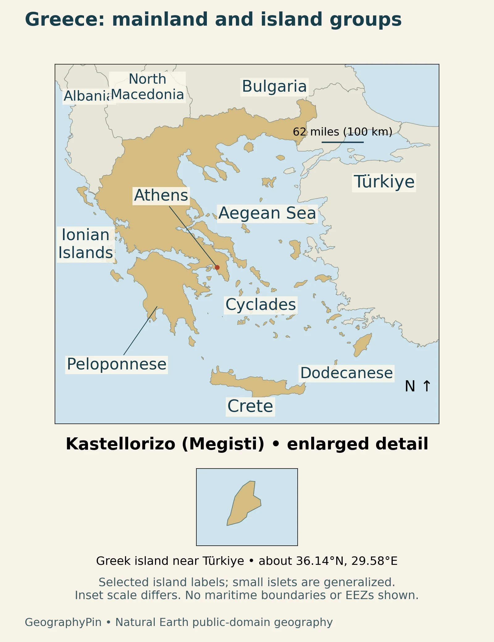
Greece lies at the southern end of the Balkan Peninsula in southeastern Europe. Its four land neighbors are Albania, North Macedonia, Bulgaria and Türkiye. The Ionian Sea lies to the west, the Aegean to the east, and the wider Mediterranean connects its southern coasts and islands. These relationships place Greece between a continental interior and several interconnected marine regions.
A country outline includes more than the peninsula
Crete, the Ionian Islands and the islands of the Aegean are essential parts of the national geography. Kastellorizo, also called Megisti, lies farther east than Rhodes and can disappear from maps cropped too tightly around the mainland. Cyprus, by contrast, is a separate country, not another Greek island group.
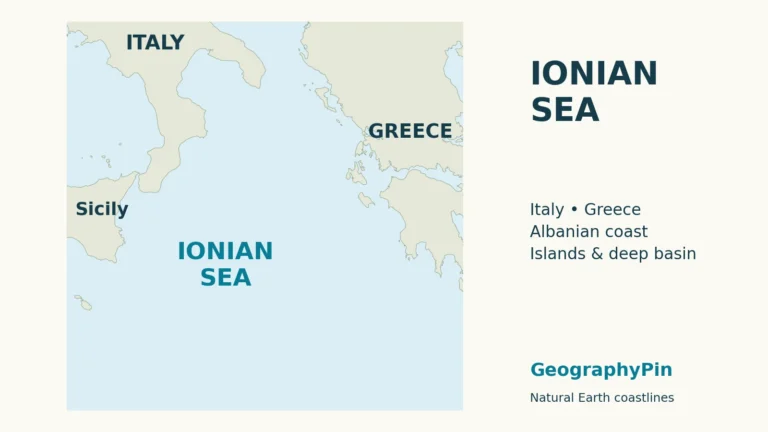
Use the national overview together with the map for orientation, then follow the separate Aegean Sea and Ionian Sea articles for the surrounding waters. Land outlines alone cannot explain jurisdiction at sea, and the country map deliberately makes no such claim.
2. Country facts with dates and scope
The population below counts usual residents across the country, including its islands. The area and population figures have different reference dates, shown alongside them.
| Topic | Fact | Scope |
|---|---|---|
| Capital | Athens | National capital |
| Area | About 50,847 sq mi (131,694 km²) | EU overview, 2026 geographical-size series |
| Population | 10,372,335 usual residents | ELSTAT estimate for January 1, 2025 |
| Language | Greek | Official language |
| Currency | Euro (€) | National currency |
| Political system | Parliamentary republic | Head of government and head of state are distinct roles |
ELSTAT’s December 18, 2025 release provides the population figure. The EU country overview supplies the geographical-size series and basic institutional context. A resident estimate is distinct from citizenship counts and from the earlier census used for the regional comparison below.
3. Mountains, basins and mainland peninsulas
Pindus and the contrast between western and eastern Greece
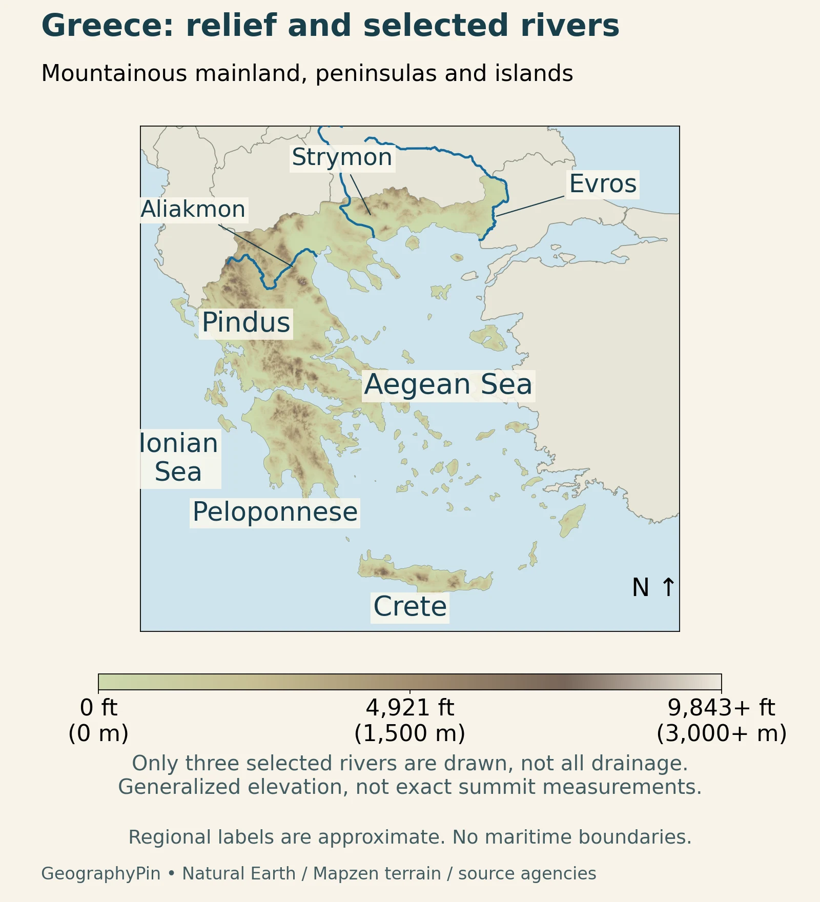
Mountain chains and enclosed basins interrupt the mainland rather than forming one smooth upland surface. Pindus is a major organizing feature of western and central Greece. Epirus lies between this mountain country and the Ionian coast, while Thessaly occupies a different setting to the east. A journey across the country therefore crosses contrasting relief, not simply successive administrative regions.
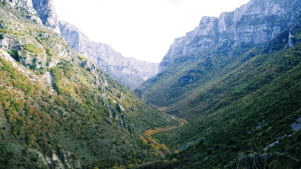
The Epirus overview places rugged slopes, gorges and forests alongside the region’s coast and lakes. The featured photograph shows Vikos Gorge in this northwestern mountain setting.
The Peloponnese is a peninsula with a canal across its neck
South of central Greece, the Peloponnese has its own mountain interior, including Arcadia, and deeply indented coasts. The regional landscape description makes the contrast between interior uplands and coastal towns clear. Its uplands and coastal indentations give the peninsula an identity distinct from the Athens area.
The Municipality of Corinth distinguishes two features often confused on small maps: the isthmus is the narrow land connection, while the canal cuts across it and connects the Corinthian and Saronic gulfs. It is an engineered passage through an existing geographic bottleneck.
The FAO physical-geography account describes mainland plains and valleys within a predominantly mountainous landscape. Thessaly’s connected basins contrast with the rugged country of Epirus, while lowlands occupy a more limited part of the Peloponnese. These are stable landform relationships, not current measurements of farmland or settlement density.
4. Island groups and contrasting coasts
The Aegean and Ionian groups are not interchangeable
The national tourism organisation’s island classification distinguishes the Ionian Islands, Cyclades, Dodecanese, North Aegean islands, Sporades and Argosaronic islands, while also treating Crete and Evia separately. These names help organize a complex map; they are not a claim that every group has identical terrain, climate or settlement patterns.
The Ionian Islands lie along the western side of Greece. In the Aegean, the Cyclades occupy a different setting from the Dodecanese farther southeast. Crete stretches across the southern part of the Greek island world. Recognizing these positions is more useful than memorizing a single total of islands and islets, which depends on what a source counts.
The Cyclades include Naxos, Paros, Mykonos and Santorini. Even within this group, the landscapes differ: Santorini and Milos have conspicuous volcanic features, while Andros is described by GNTO as greener than the familiar dry Cycladic image. An archipelago is a geographic grouping, not proof that all its islands formed or developed in the same way.
The Dodecanese include Rhodes and Kos as well as islands farther from the mainland. Their southeastern position explains why a mainland-centered map is insufficient. For individual destinations, see the separate Greek islands article; this profile concentrates on the national arrangement rather than ranking holiday choices.
5. Climate across a mountainous country
Mediterranean climate does not mean identical weather everywhere
The European Commission’s climate overview describes hot, dry summers and mild, wetter winters as a broad Mediterranean pattern, with cooler conditions in northern and high-mountain areas. Elevation, exposure and distance from the sea matter alongside latitude. A mountain settlement and a low coastal town can therefore experience very different conditions within the same country.
Season and elevation need to be read together. The same country includes low maritime settings and much colder mountain environments, so the familiar summer image of Greece describes only part of its climatic range.
The Bank of Greece climate assessment explains the west–east contrast: moist air arriving from the west encounters Pindus, favoring greater precipitation on its western side than farther east. This broad effect helps connect the terrain pattern to climate without implying that every place west of the range has the same rainfall.
River catchments also cross national borders. The Evros, Nestos and Strymon begin in Bulgaria, while the Axios begins in North Macedonia. Water entering northern Greece is therefore connected to conditions upstream in other countries. The relief map draws selected river courses only; it does not depict every catchment or provide a current assessment of river flow.
6. People, cities and geographic names
Athens, Attica and the national population are different scales
Athens is the national capital, while Attica is the wider administrative region surrounding it and extending beyond the city. ELSTAT’s 2021 census table for Attica records 3,814,064 residents. That is a regional figure, not the population of the Municipality of Athens, and it should not be relabeled as a metropolitan-area count without checking the boundary used.
The distinction matters when comparing cities or describing settlement. A regional total includes places outside the central municipality; a national resident estimate includes islands and rural districts as well as urban areas. The 2021 census and the 2025 estimate answer related but different questions.
Greek is the official language. Place names may nevertheless appear in different transliterations on maps, such as Pindus and Pindos. Matching the location is more reliable than assuming that a spelling variation always identifies a different feature. Administrative regions, island groups and physical landscapes also overlap without being identical categories.
Thessaly offers a useful smaller-scale example. GNTO’s regional account places Larissa on the Pineios River, Volos beside the coast and Pelion, and Kalampaka at Meteora. These are different settings within one region, showing why neither “mountainous Greece” nor “coastal Greece” is a complete description of everyday settlement.
7. Economy in its geographic setting
Ports connect the coast with a wider hinterland
Piraeus illustrates how a coastal location becomes an economic connection. The port authority describes maritime links across the Mediterranean and road and rail links toward the Balkans and Central Europe. Its relationship with Athens is important, but its connections do not stop at the city boundary. A port serves networks as well as the immediate shoreline.
Farming faces a different set of geographic constraints. The European Commission’s Greek agricultural overview identifies steep slopes, low temperatures, dry soils and island conditions among the factors affecting agricultural land. It also describes the importance of family holdings and relatively small farms. These conditions vary locally, so a mountain pasture and a cultivated lowland cannot be treated as the same production environment.
The practical lesson is that geography creates both connections and constraints. A deeply indented coast offers many distinct coastal settings, while mountains and sea passages can separate nearby places. Transport infrastructure, land use and settlement decisions determine how those physical conditions become part of the economy; terrain alone does not explain every regional difference.
What Did We Learn Today?
Greece’s geography cannot be reduced to either its mainland or its islands. Mountain systems, enclosed basins, coastal passages and archipelagos create distinct regional settings. Pindus helps explain a broad west–east climate contrast, while northern rivers connect Greece with upstream neighbors. Country statistics, city populations and regional totals make sense only when their dates and geographic boundaries are kept clear.
Sources & Data Notes
National population is ELSTAT’s usual-resident estimate for January 1, 2025, released December 18, 2025. Attica uses the separate 2021 census. Area follows the EU overview’s 2026 geographical-size series. Historical FAO material is used only for stable physical geography, not present-day population, farming or environmental conditions; the Bank of Greece assessment supports broad climate and river relationships, not current flow measurements.
- European Union: Greece country overview
- ELSTAT: estimated resident population, January 1, 2025
- ELSTAT: Attica, 2021 census results
- Enterprise Greece: national overview
- Greek National Tourism Organisation: Epirus
- GNTO: Peloponnese
- Municipality of Corinth: the isthmus and canal
- GNTO: island groups
- GNTO: Cyclades
- GNTO: Dodecanese
- GNTO: Thessaly
- Piraeus Port Authority: container terminal connections
- European Commission: Greece’s agricultural strategy
- European Commission: Greece climate context
- Bank of Greece: climate assessment, chapter 2, pages 128–129
- FAO: Greece’s physical geography and river systems
Original maps: GeographyPin, based on Natural Earth public-domain geography. Kastellorizo uses an actual Natural Earth land polygon omitted from the country outline, with identity checked against the municipality’s description. Small islands and river courses are generalized; the locator inset has a different scale. The locator does not depict maritime boundaries or exclusive economic zones. The relief map is a selected physical overview, not a complete inventory of rivers or exact mountain-range boundaries.
Elevation uses Mapzen Terrain Tiles. Credit: Mapzen; Europe data produced using Copernicus data and information funded by the European Union, EU-DEM layers; USGS SRTM/GMTED2010; NOAA ETOPO1. See the terrain attribution. Display enlargement does not increase the precision of the underlying elevation data.
Featured photograph: Vikos Gorge, November 2016, Irini Papalexi, CC BY-SA 4.0. Slightly cropped and resized; the derivative retains the same license.