Jordan is often pictured through one striking landscape: Petra’s rock-cut façades, Wadi Rum’s sandstone cliffs or the Dead Sea’s shore. A country map connects those places to a much broader pattern. Low western terrain, higher settled country and an extensive eastern desert sit beside a short but important opening to the sea.
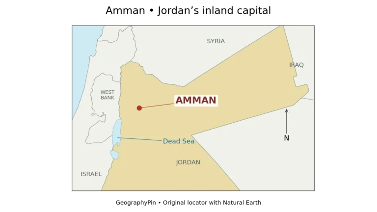
Jordan is a country in Western Asia whose geography contrasts the Jordan Rift Valley and Dead Sea in the west, a belt of uplands, and the eastern desert. Amman is its capital. A short coastline at Aqaba gives the country access to the Red Sea, while water scarcity shapes settlement, agriculture and infrastructure.
How to use this article: Separate national totals from local counts, follow three contrasting landscapes, or see why water supply matters.
1. Where is Jordan?
Jordan lies east of the Mediterranean, but it has no Mediterranean coastline. Syria is to its north, Iraq to its northeast, and Saudi Arabia to its east and south. Israel and the West Bank, a Palestinian territory, lie along its western side. Its southwestern tip reaches the Gulf of Aqaba, an arm of the Red Sea. UNFPA Jordan: country geography and national context provides the regional orientation.
On the map, follow the country from Amman toward Aqaba rather than treating its eastern border as the main axis of settlement. The capital sits in the western part of Jordan, while the large eastern extension occupies much of the national outline. The country’s shape and the distribution of its cities are different geographic patterns.
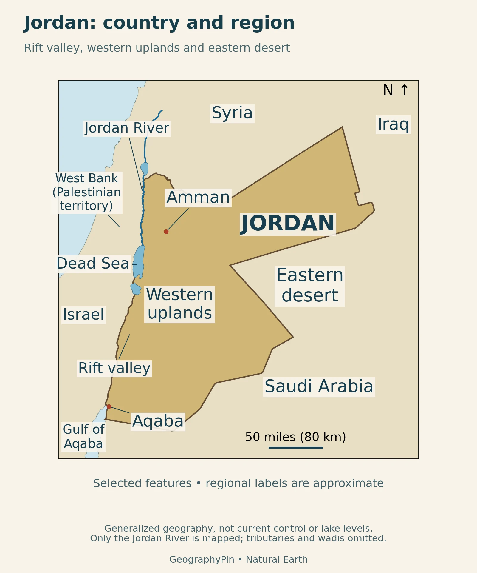
The Jordan River is not the country’s entire western boundary, and the Dead Sea is not an opening to the ocean. Following the western lowlands southward ultimately brings you toward Aqaba, but this does not create a continuous navigable waterway. For the surrounding marine geography, see the Red Sea map.
2. National facts with dates attached
Jordan’s official statistics distinguish total area from land area and national population from the population of individual governorates. The table keeps those categories separate. It also gives the reference period of an estimate rather than presenting a changing total as a timeless fact.
| Topic | Figure or description | Scope |
|---|---|---|
| Capital | Amman | National capital |
| Total area | About 34,486 sq mi (89,318 km²) | 2025 DoS table, including territorial water |
| Land area | About 34,284 sq mi (88,794 km²) | Land only in the same table |
| Population | 11,937,000 | End of 2025 national estimate |
| Official language | Arabic | Not the only language spoken |
| Currency | Jordanian dinar (JOD) | National currency |
| Highest point | Jabal Umm ad Dami, about 6,083 ft (1,854 m) | Elevation above sea level, DoS 2025 |
Area and elevation come from Jordan in Figures 2025: area and topography, printed pages 8 and 12; population comes from the Jordan Department of Statistics: end-2025 population estimates, issued in January 2026.
Area, population and the unit being counted
A resident total is not the number of citizens living worldwide. A governorate is an administrative region, not necessarily the built-up city bearing its name. Similarly, including territorial water produces a different area from counting land alone. These distinctions explain why two apparently comparable figures may actually describe different things.
3. From the western lowlands to the desert plateau
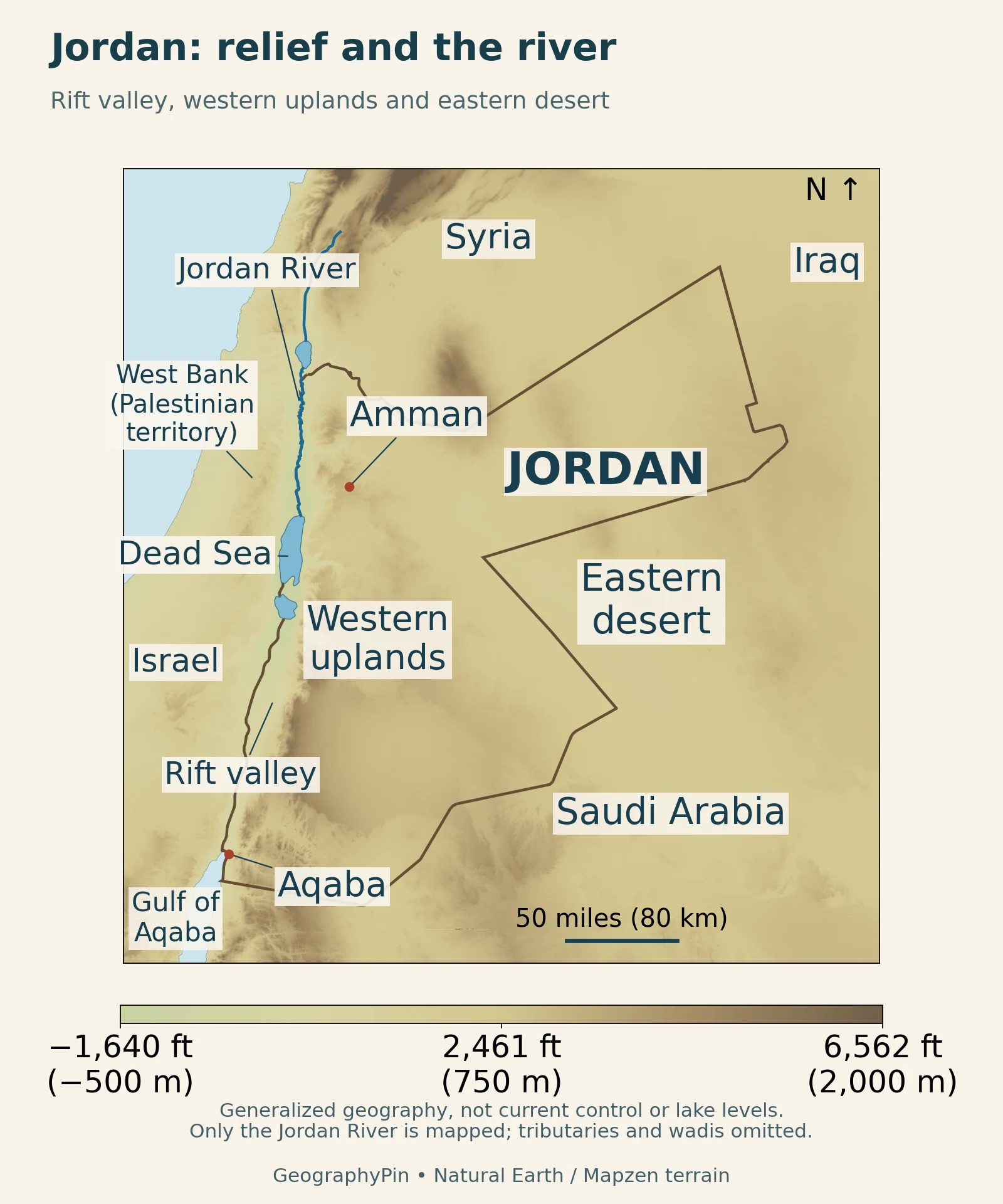
A useful broad division separates the western rift-valley lowlands, the uplands farther east and the extensive Badia desert. Jordan’s 2021 NDC: national geography, page 5 describes the uplands as the belt between the valley and the eastern plains. It also identifies this western highland zone with many population centers, including Amman, Irbid, Zarqa, Madaba and Karak.
Three landscapes, not three sealed compartments
Read the relief map from west to east. The abrupt change from low ground toward the uplands matters more than a national average elevation. Farther east, broad areas of higher ground may look comparatively smooth at this scale. Smooth shading does not mean that every surface is flat, sandy or easy to cross.
The broad regions are a guide to contrast, not surveyed boundaries around uniform terrain. A valley cutting into an upland does not stop belonging to the larger regional landscape. Nor does the label “desert” describe one rock type: it refers to dry conditions, and can include plains, exposed rock and rugged relief.
The western uplands generally receive more winter rain than the eastern desert. Summers are long and dry; winter conditions are cooler. A desert-country label therefore should not be read as a promise of identical weather in Amman, Aqaba and the Badia. These are broad climate patterns, not a forecast for a particular visit.
4. The Dead Sea and Wadi Rum explain different processes
The western depression is associated with the Dead Sea transform fault system. USGS: Dead Sea fault-zone basins describes basins that developed along this continental plate boundary. Calling the landscape a rift valley does not mean it is simply an ocean basin opening evenly along its length: fault movement and local subsidence have produced different basins.
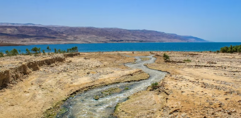
The International Union of Geological Sciences: Dead Sea geoheritage describes the Dead Sea as a terminal, hypersaline lake. Water arrives in its basin but has no river outlet to the sea; evaporation is central to its water balance and concentrated brine. The shoreline changes as the lake level changes, so a map outline or an undated elevation is not a measurement of today’s conditions.
For a fuller treatment of the lake itself, see the Dead Sea profile. Here its main role is geographic: it marks a low western landscape sharply different from the uplands overlooking it.
Wadi Rum is more than a field of dunes
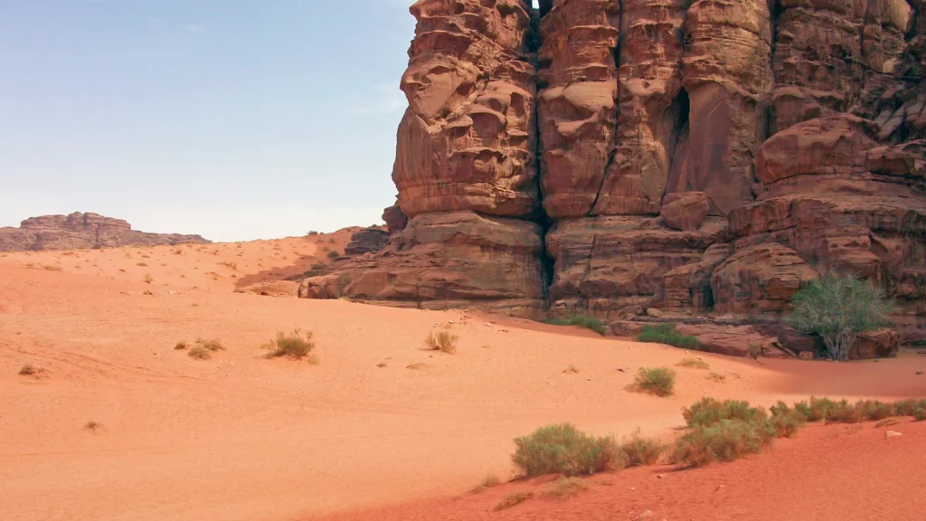
In southern Jordan, Wadi Rum shows another kind of relief. UNESCO: Wadi Rum Protected Area describes desert landforms developed in sandstone, including steep cliffs, narrow gorges and natural arches. Tectonic structure, weathering and erosion all helped shape the scene. Its cultural heritage also records a long relationship between people and the landscape.
The featured photograph shows this sandstone-and-sand setting, not a typical view of every part of Jordan. Its cliffs contrast with both the low Dead Sea basin and the broad eastern plains.
5. Why water supply matters beyond the map
Relief helps explain where water can move, but a shaded elevation map cannot show how much usable water people receive. FAO: water scarcity and irrigation in Jordan identifies groundwater overuse, reliance on some non-renewable aquifers and the importance of agriculture in national water demand. Treated wastewater is also an important irrigation resource.
A river, an aquifer and a water service are different things
River flow is surface water moving through a channel. Groundwater occupies spaces in rock and sediment. A household supply is a managed service that may involve abstraction, treatment, pumping and distribution. The presence of one river on a map therefore says little by itself about the reliability of a tap in a distant settlement.
The World Bank: Jordan Water Sector Efficiency Project, June 2023 illustrates this distinction. Its 2023 project description focused on reducing water losses, lowering energy use and improving drought management. The program’s stated objectives are not evidence that every promised improvement has already been delivered.
Aqaba’s coast provides access to seawater, not an unlimited supply of drinkable freshwater. Turning a coastal resource into a usable supply for inland communities involves infrastructure and energy. Water planning must therefore connect physical geography with engineering, demand and the condition of the distribution system.
6. People, cities and the scale of a place
Amman is the capital, but “Amman” can also mean the much larger governorate. The end-2025 DoS table estimates 5,004,600 people in Amman Governorate, or 41.9% of the national total. That is not a city-proper count. Irbid and Zarqa are also major population centers, while Aqaba has a distinctive coastal setting.
A useful map comparison separates the capital’s administrative role from the country’s physical regions. A governorate boundary describes an administrative unit. An upland or river valley describes terrain. Neither is a substitute for the other, and the population attached to one cannot simply be transferred to the other.
For a closer look at the capital’s own terrain and setting, see Amman’s geography and map.
Arabic is the official language and the Jordanian dinar is the currency, as listed by the Jordan Integrity and Anti-Corruption Commission: official language and currency. The Royal Hashemite Court: Jordan’s system of government describes a parliamentary system with a hereditary monarchy. The monarch’s constitutional role is not merely ceremonial; national institutions and everyday language use are different aspects of a country profile.
7. Aqaba and the geography of the economy
Jordan’s short coast has a role larger than its length suggests. Aqaba Development Corporation: transport and logistics describes the port and logistics facilities that connect Aqaba with inland transport and international shipping. Access to the sea is a national economic link, not just a feature of a seaside city.
The Jordan Phosphate Mines Company: mines and Aqaba facilities identifies inland mines at Al Hasa, Al Wadi Al Abyad and Eshidia, alongside processing and export facilities at Aqaba. This connects geological resources in central and southern Jordan with an outlet to overseas markets. It does not mean every processing step occurs at the mine itself.
Potash follows a different resource pathway. The Arab Potash Company: production process explains how Dead Sea brine is pumped into solar ponds, where evaporation helps concentrate salts. Harvested material is refined, and finished potash is transported to Aqaba for shipment. Dissolved minerals recovered from brine should not be confused with phosphate rock extracted from inland mines.
Mining is only one part of the economy. The DoS’s preliminary 2025 accounts put manufacturing at 17.0% and mining and quarrying at 3.5% of GDP measured at constant 2023 prices. Trade, transport, finance and other services add further activities. Those percentages describe output on that statistical basis, not shares of jobs or exports.
What Did We Learn Today?
Jordan is not one continuous desert landscape. Its western lowlands, uplands, eastern plateau and Aqaba coast play different roles. Country statistics are clearest when the reference year and territory remain attached, while a relief map becomes more useful when it is read alongside the water systems and settlement patterns it cannot show on its own.
Sources & Data Notes
Population refers to the end of 2025; the DoS publication appeared in January 2026. Area and highest-point figures use Jordan in Figures 2025. Economic percentages are preliminary 2025 estimates at constant 2023 prices, not nominal GDP or employment shares. Statistical reference periods and publication dates are different.
Original GeographyPin cartography uses public-domain Natural Earth outlines and selected water features. Neighbor labels are geographic orientation, not a depiction of current control. The Jordan River is shown, but tributaries and wadis are omitted. Generalized lake outlines are not current shorelines.
The relief image uses historical Mapzen Terrain Tiles, decoded from Terrarium elevation data and displayed in Web Mercator. Its approximate source-cell spacing is 1,700 ft (520 m) at the map’s central latitude; that is not survey accuracy. The scale bar is a local approximation. Attribution: Mapzen Terrain Tiles; SRTM and GMTED2010 data courtesy of the U.S. Geological Survey; global ETOPO1 data: NOAA. See the elevation-source attribution. Colors do not establish exact summit elevations or today’s Dead Sea level.
Featured photograph: Wadi Rum, April 2009, Daniel Case, CC BY-SA 3.0. Cropped to a wide frame, resized and converted to WebP; this derivative remains under the same license.
- UNFPA Jordan: country geography and national context
- Jordan Department of Statistics: end-2025 population estimates
- Jordan in Figures 2025: area and topography, printed pages 8 and 12
- Jordan’s 2021 NDC: national geography, page 5
- USGS: Dead Sea fault-zone basins
- International Union of Geological Sciences: Dead Sea geoheritage
- UNESCO: Wadi Rum Protected Area
- FAO: water scarcity and irrigation in Jordan
- World Bank: Jordan Water Sector Efficiency Project, June 2023
- Royal Hashemite Court: Jordan’s system of government
- Jordan Integrity and Anti-Corruption Commission: official language and currency
- Jordan Phosphate Mines Company: mines and Aqaba facilities
- Arab Potash Company: production process
- Aqaba Development Corporation: transport and logistics