Great Bear Lake’s five broad arms spread across northern Canada like the branches of a water-filled landscape. Reading those arms, the southwestern outlet and the community of Délı̨nę together reveals more than a list of impressive dimensions.
Great Bear Lake, also known as Sahtú, is a large freshwater lake in Canada’s Northwest Territories. It is the lake with the greatest surface area entirely within Canada. Its five main arms connect to a southwestern outlet through Great Bear River to the Mackenzie, while Délı̨nę is a community closely tied to its waters and cultural landscape.
How to use this article: Interpret the lake’s measurements, trace its drainage connection, or distinguish its cultural and biosphere designations.
1. Where Is Great Bear Lake?
Great Bear Lake lies in the Northwest Territories of northern Canada. The Arctic Circle crosses its northern part, while the community of Délı̨nę stands beside Keith Arm in the southwest. The Government of the Northwest Territories identifies it as the lake with the greatest surface area entirely within Canada.
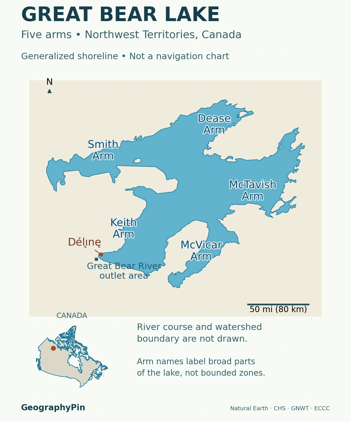
Sahtú is the lake; Délı̨nę is a lakeshore community
Sahtú is the Indigenous name used for Great Bear Lake in Parks Canada’s material developed with the Délı̨nę Got’ı̨nę Government. Délı̨nę is a community, not another name for one of the lake’s arms. Keeping the lake, community and surrounding cultural landscape distinct makes the map easier to understand.
The five-armed shape is the lake’s most recognizable feature. Broad expanses connect to long bays separated by substantial peninsulas. On a small-scale map those arms can look like separate lakes, but they are parts of one connected freshwater system.
The locator is designed for regional orientation. It identifies the arms, Délı̨nę and the outlet area rather than charting shoals, travel routes or safe crossings. The outline is generalized: a bay or island omitted at this scale has not disappeared from the real shoreline.
2. How Large and Deep Is Great Bear Lake?
A 2015 Fisheries and Oceans Canada technical report provides the following set of physical measurements. They are reference figures quoted by that report, not the results of a new 2015 bathymetric survey or present-day water-level observations.
| Measure | Reported figure with rounded U.S. conversion |
|---|---|
| Surface area | About 12,028 square miles (31,153 square kilometers) |
| Maximum recorded depth | About 1,463 feet (446 meters) |
| Mean depth | About 235 feet (71.7 meters) |
| Water volume | About 536 cubic miles (2,236 cubic kilometers) |
Maximum depth is not typical depth
The difference between maximum and mean depth is substantial. The deepest recorded location does not describe every arm, bay or crossing. Nor is either depth figure the lake’s elevation above sea level: depth measures downward from the water surface, whereas elevation uses a separate vertical reference.
Published area figures differ. The territorial water-stewardship page gives about 12,096 square miles (31,328 square kilometers), while the DFO report uses the smaller figure in the table. These sources do not establish a measured loss of lake area between their publication dates. Without comparable shoreline definitions and methods, their difference should not be presented as evidence that the lake shrank.
For the same reason, broad global rankings can depend on how waterbodies are grouped and measured. The clearer geographic distinction here is that Great Bear Lake lies wholly within Canada; it does not straddle an international boundary.
3. Five Arms and a Route to the Mackenzie River
The five principal arms provide a useful framework for reading Great Bear Lake. Starting near the southwestern outlet and moving clockwise, they are Keith, Smith, Dease, McTavish and McVicar.
| Arm | General position |
|---|---|
| Keith Arm | Southwest, near Délı̨nę and the outlet |
| Smith Arm | Northwest |
| Dease Arm | Northeast |
| McTavish Arm | East |
| McVicar Arm | South |
Great Bear River carries water out of the lake
Water leaves Great Bear Lake through the Great Bear River near the southwestern end of Keith Arm. The river then joins the Mackenzie River. Parks Canada describes this connection when explaining Délı̨nę’s name and its relationship with nearby flowing water.
The river’s outlet from the lake is its upstream end, not its mouth at the Mackenzie. That distinction matters when a map labels Délı̨nę, the lake outlet and a downstream confluence: they are not interchangeable locations.
A watershed is the land and water that drain toward a common outlet, not simply the lake’s blue outline. The map marks the outlet area but does not depict the complete river course or delineate the catchment. A drainage description and a surveyed catchment map answer different questions.
4. An Ice-Age Landscape with Uneven Summer Warming
Glaciers reshaped the northern landscape, scouring surfaces and leaving sediments as the ice retreated. Great Bear Lake’s history is also connected to glacial Lake McConnell, a much larger body of water that occupied parts of the Great Bear, Great Slave and Athabasca lake basins during deglaciation.
The Délı̨nę language-documentation project describes how retreating ice and the rebound of the land changed that larger lake system, leaving the modern lakes behind. This does not mean that today’s shoreline is an unchanged outline of Lake McConnell, or that one simple ice-age event explains every modern bay.
The central lake and sheltered arms do not warm identically
A 2024 study of Great Bear Lake’s circulation distinguishes cold central waters from seasonally warmer margins and arms. Its evidence includes observations from 1964 and moorings deployed in 2008–2009, alongside satellite information. The publication date is not the date of all those measurements.
The study shows why describing the entire lake as uniformly cold and unmixed is misleading. Different parts can develop different temperature and density structures. Deep McTavish Arm adds another setting in which pressure and mixing processes matter.
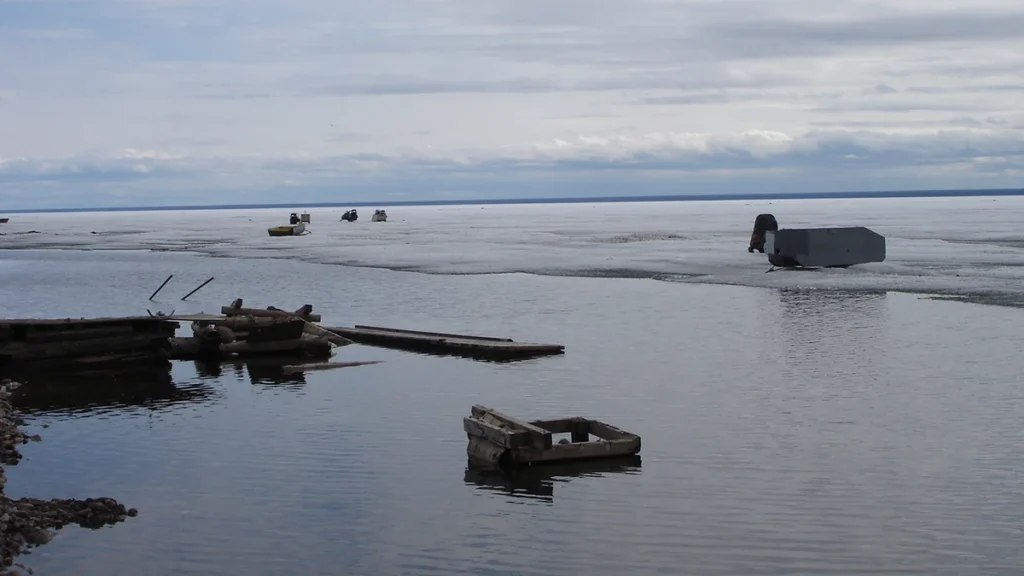
Those findings explain a physical pattern, not today’s swimming temperature or a safe date to cross the ice. Freeze-up, breakup and local conditions vary. A historical photograph showing shore ice documents its own moment; it cannot establish the state of the lake for a future visit.
5. Délı̨nę, Sahtú and a Living Cultural Landscape
Great Bear Lake is a homeland, not an empty wilderness awaiting discovery. UNESCO identifies the surrounding area with the Sahtuto’ine, the Bear Lake People, and describes the close relationship between the lake, livelihoods, knowledge and community life in Délı̨nę.
The biosphere reserve and historic site are different designations
Tsá Tué joined UNESCO’s biosphere-reserve network in 2016. It encompasses Great Bear Lake and part of its watershed. A biosphere reserve is not the same designation as a UNESCO World Heritage Site, and its extent should not be substituted for the whole lake catchment.
Saoyú-ʔehdacho National Historic Site concerns two major peninsulas reaching into the lake. Parks Canada identifies them as teaching, healing and spiritual places important to the Sahtúgot’ı̨nę. Parks Canada dates the site’s designation to 1997 and identifies its cooperative management by the Délı̨nę Got’ı̨nę Government and Parks Canada.
Community knowledge is part of the landscape’s present, not only its past. Parks Canada describes Elders sharing stories, land-use skills and other knowledge with younger generations. Learning from community-led interpretation is more respectful and informative than treating culturally important places as anonymous scenery.
6. Access Requires Local and Seasonal Planning
The Government of the Northwest Territories describes access to Délı̨nę as primarily by air, with a winter road available when it is open. This is not an all-season road connection, and an old map or a typical winter month cannot confirm that the road is usable.
Check conditions rather than relying on a seasonal rule
The official DriveNWT highway conditions service provides road advisories, closures and weight restrictions. Check the applicable route and current notice before planning a road journey. Airline arrangements, local transfers and on-water travel require their own confirmation.
For Saoyú-ʔehdacho, start with Parks Canada’s official site information and local guidance. A community visit, travel to a remote peninsula and an extended trip on the lake are different undertakings. A regional geography map is not a substitute for navigation information or local advice.
The same distinction applies to lake measurements. Maximum depth and surface area help explain the scale of Great Bear Lake, but they do not identify safe landing places, ice routes or boating conditions. For the wider physical definition, see what is a lake?
What Did We Learn Today?
Great Bear Lake’s five arms, deep water and southwestern outlet place it within a larger northern drainage system. Published measurements need their source context, and the cold central lake does not behave exactly like its sheltered arms. Sahtú is also a living cultural landscape: understanding Délı̨nę and the different conservation designations is part of understanding the lake.
Sources & Data Notes
The physical table retains a single reported measurement set from DFO’s 2015 technical report; metric source values have rounded U.S. customary conversions. The territorial government’s alternative area is identified separately, not interpreted as a measured change. Research publication dates are distinguished from observation dates. No current ice, water-quality or road-opening guarantee is implied.
- Northwest Territories Water Stewardship: wholly Canadian location and reported area
- Fisheries and Oceans Canada, 2015: physical reference measurements and five arms
- Carmack, Vagle and Kheyrollah Pour, 2024: seasonal temperature and circulation patterns
- Délı̨nę language-documentation project: geographic and glacial landscape context
- UNESCO: Tsá Tué Biosphere Reserve
- Parks Canada: Saoyú-ʔehdacho and cooperative management
- Parks Canada: Sahtú, Délı̨nę and Great Bear River
- Government of the Northwest Territories: Délı̨nę community access
- Northwest Territories Infrastructure: current road conditions and advisories
Featured photograph: Great Bear Lake by mattcatpurple, May 24, 2006, under CC BY-SA 2.0. Cropped, resized and converted to WebP; this adaptation remains under the same license. This archival shoreline-thaw scene does not establish current ice conditions. No synthetic content or GeographyPin watermark was added.
Map methods: The Natural Earth lake polygon supplies a generalized shoreline, drawn in a local azimuthal equidistant projection. The five-arm identification follows Canadian Hydrographic Service ARC404, chapter 10. The community locator uses a GNWT monitoring-project reference; the outlet-area marker uses the Environment and Climate Change Canada hydrometric station. That station locates the outlet area, not a precisely surveyed shoreline opening. The separate-scale Canada inset provides national context only. River courses, catchment boundaries, depth contours and Indigenous jurisdictional boundaries are not shown.