Types of human geography are the major subfields that explain how people, societies, economies, and power organize across space—and why outcomes change when location changes. These types overlap in real life: a border story can also be a trade story, and a housing story can also be a migration story.
Types of human geography are the main branches that study human life through a spatial lens—population and migration, culture, social life, cities, the economy, politics, and historical change. A widely cited summary notes five long-running divisions (economic, social, cultural, political, and historical geography) (Encyclopaedia Britannica, 2025), while education overviews commonly list examples like urban, economic, cultural, political, social, and population geography (National Geographic Education, 2026).
How to use this article: If you keep mixing terms, start with Common confusions, then use the at-a-glance table. If you just want the right label fast, jump to Fast check or scan the Methods toolkit, then finish with the FAQ.
What “types of human geography” means (and common confusions)
“Types of human geography” usually means subfields: the big topic lenses inside human geography. Each lens highlights what matters most on the map—movement, identity, access, trade routes, borders, risk, or the long shadow of history.
One problem can sit in multiple types. A new highway can be urban geography (access and land use), economic geography (markets and logistics), and social geography (who benefits and who gets displaced). The goal is to choose the lens that explains the main mechanism, then add secondary lenses where they genuinely help.
Common confusions (fixed in one minute)
- Human vs physical geography: human geography focuses on cultures, societies, economies, and power; physical geography focuses on landscapes and environmental processes. Both care about place, but they ask different questions.
- Types of geography vs types of human geography: “human vs physical” are the main branches of geography; “urban vs cultural vs political” are types inside human geography.
- Regions are not a type: “Middle East” is a region; “political geography” is a lens you can use to explain that region.
- Geopolitics is not the whole field: it’s a strategic slice of political geography, not a replacement for migration, cities, culture, or economics.
If you remember one line: human geography explains people and systems through location and spatial patterns.
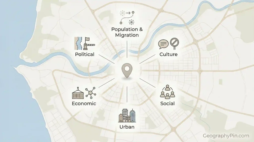
The core map of the field
Human geography has several common ways of dividing the field. One well-known summary describes five long-running divisions—economic, social, cultural, political, and historical geography (Encyclopaedia Britannica, 2025). Education overviews often present the field by listing common example subfields students meet first, including urban, economic, cultural, political, social, and population geography (National Geographic Education, 2026).
Think of the “core divisions” as the spine of the field, and the frequently taught subfields as practical branches that combine those divisions in real-world topics.
At-a-glance table: types and what they explain
| Type | The question it answers | A real-world example (one sentence) |
|---|---|---|
| Population & migration | Where people live, how movement happens, and where friction blocks it | A city grows fast, but the growth concentrates in certain districts because newcomers follow jobs and housing networks. |
| Cultural | How identity and meaning create boundaries, regions, and landscapes | Two neighborhoods share a border on paper, but language and institutions make the boundary feel real. |
| Social | How inequality and everyday life vary across space | Emergency response times differ sharply across the same city because infrastructure and service coverage are uneven. |
| Urban & settlement | How land use, housing, transport, and access shape city outcomes | A new rail station changes rent patterns because access to jobs becomes a competitive advantage. |
| Economic | How trade, jobs, and production cluster around routes, hubs, and rules | A port city pulls investment because logistics and export routes reduce time and risk for firms. |
| Political & geopolitics | How borders, territory, governance, and strategy shape what’s possible | Prices rise near a border crossing because permits, inspections, and delays concentrate scarcity. |
| Historical | How past borders, routes, and policies still structure today’s map | A “new” conflict follows old lines because the administrative map was drawn decades earlier. |
A simple way to choose the right type
When a topic feels messy, start with one question: what is doing the work on the map? Movement, access, identity, trade routes, rules, or history. The answer usually points to the most useful type—and explains why other types might also matter.
Population and migration geography
Population geography explains where people live and how populations change across space. Migration geography explains how movement works in the real world: routes, networks, barriers, and the policy friction that turns a straight line into a long detour.
What this type does better than the others
It explains uneven change. Why one region empties out while another packs in. Why growth concentrates in specific districts. Why border regions feel pressure first when rules tighten.
Three concepts that show up everywhere
- Networks: people move along information and family ties as much as along roads.
- Gateways: a small number of cities and crossings can shape a much larger migration geography.
- Scale: neighborhood churn and cross-border migration can be the same story at different levels.
Good migration explanations avoid fake precision. Clear mechanisms beat guessed numbers.
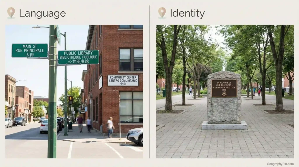
Cultural geography and cultural landscapes
Cultural geography studies how meaning becomes place: language, religion, identity, memory, and belonging expressed across space. It’s not “culture as a label.” It’s culture as patterns you can see—on signs, in street layouts, in sacred spaces, in who feels welcome where.
Cultural landscapes: evidence you can walk through
A cultural landscape is the physical imprint of human life: architecture, land boundaries, farming patterns, cemeteries, monuments, markets, and the everyday design choices that tell you who a place is built for.
Diffusion with friction
Ideas spread through routes—migration, media, schools, trade—but the spread is uneven. Distance matters, but so do institutions, discrimination, state policy, and digital access. Cultural geography is where you explain why a trend races through one corridor and stalls in the next valley.
If your story is about identity lines that don’t match administrative borders, cultural geography is usually the correct lead lens.
Social geography (often confused with cultural)
Social geography focuses on how social life varies across space: inequality, segregation, class, safety, care work, and the everyday geography of who can access what. It overlaps with cultural geography, but it is usually more direct about unequal outcomes.
A quick way to separate social from cultural
Cultural geography often leads with meaning and identity in place (language, religion, belonging, memory). Social geography often leads with uneven conditions (access, services, risk, segregation). Strong explanations often use both.
Where social geography shows up fast
- Service gaps (schools, clinics, emergency response) that cluster by neighborhood
- Heat risk that concentrates where shade, parks, and housing quality are weaker
- Mobility gaps where “distance” is not miles but time, cost, and safety
This lens forces the question that many maps avoid: who benefits, who pays, and where does that land on the ground?
Urban and settlement geography
Urban geography explains how cities function as spatial systems: land use, housing, transport, services, and the patterns of inequality that fall out of those systems. Settlement geography widens the view to include towns, suburbs, villages, and the links between cities and their surrounding regions.
The city is a machine for distributing access
In every city, distance costs time and money. The result is predictable: better access to jobs and services becomes a premium, and neighborhoods sort by who can afford that access.
Common topics that belong here
- Housing pressure, displacement, and neighborhood change
- Commute patterns, congestion, and transit gaps
- Informal settlements, zoning, and the geography of enforcement
- Service access differences: schools, clinics, parks, emergency response
If the story changes when you redraw a commute time map, you’re in urban geography.
Economic geography
Economic geography studies where economic activity happens and why it clusters: jobs, industries, trade, investment, and the infrastructure that keeps value moving. It is the logic of hubs, corridors, and bottlenecks.
The core idea: networks beat straight lines
Markets don’t move in perfect circles around a city center. They move through routes, ports, rail nodes, border posts, and digital connections. One missing bridge or one congested crossing can reorganize opportunity across an entire region.
What economic geography looks like on a map
- Industrial belts and specialized clusters
- Supply chains that converge on a few hubs
- Trade corridors and chokepoints that amplify shocks
- Regional inequality that tracks connectivity and policy, not just “effort”
If your explanation relies on routes and nodes more than on company names, your lead lens is economic geography.
Political geography and geopolitics
Political geography studies how power is organized in space: territory, borders, governance, law, representation, and the practical geography of control. Geopolitics is the strategic layer—how location, routes, resources, and alliances shape state behavior and security decisions.
Borders are systems, not lines
A border is built from checkpoints, permits, customs rules, surveillance, and the politics of identity. Its effects spread inland through trade costs, travel restrictions, and the way people route around risk.
Three quick geopolitics triggers
- Chokepoints: narrow places where flow concentrates and leverage rises
- Buffers: zones used to absorb pressure and push threats outward
- Corridors: routes that tie economies and security together
If the story includes “who controls access,” “who sets the rules,” and “what happens to flows,” political geography is the correct anchor.
Development, health, and human–environment geography
This is where human geography turns into lived outcomes: inequality between places, access to services, and uneven exposure to risk. It also connects cleanly to physical geography, because environment becomes policy and policy becomes spatial reality.
Development geography
Development geography explains why opportunity concentrates. Connectivity, institutions, education access, and infrastructure quality create place advantages that compound. Once a region becomes a hub, it often pulls more investment and talent, widening the gap.
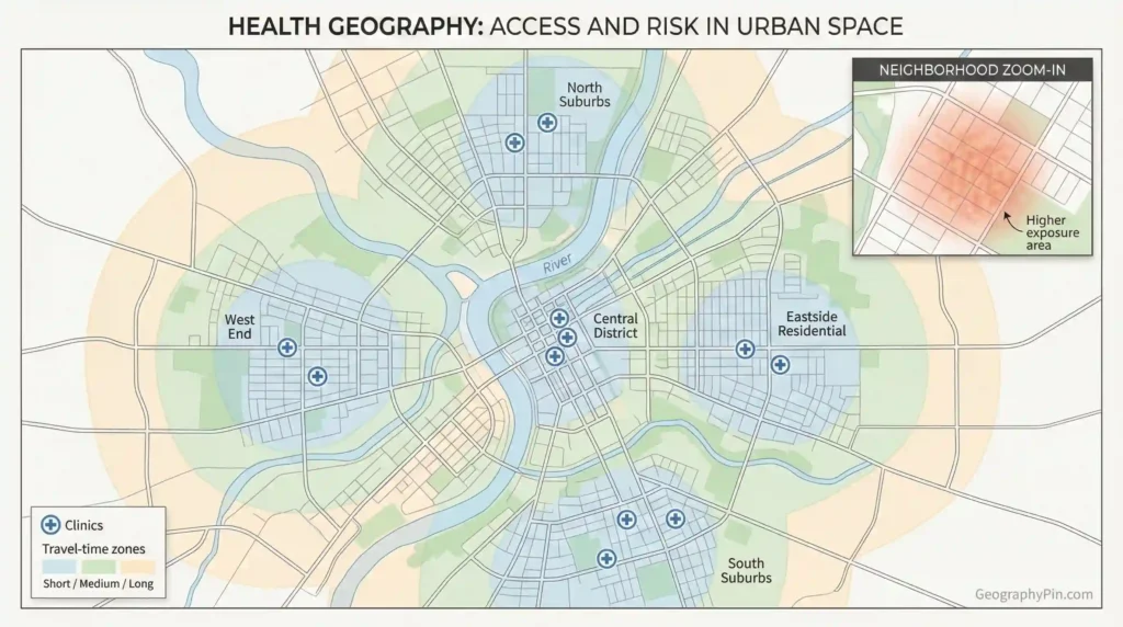
Health geography
Health geography maps where risk and access diverge: where clinics are, how far people travel, which neighborhoods face pollution or heat stress, and how outbreaks move through networks. The “health map” is usually an access map in disguise.
Human–environment geography (political ecology, environmental justice)
This lens asks who benefits from resources and who carries environmental burdens. It follows land and water governance, extraction, conservation, hazard exposure, and the disputes that look environmental but are really about rights and control.
Methods and skills human geographers use
Human geography is defined by the spatial question first, then it picks tools that fit. Some projects are map-and-data heavy. Others rely on fieldwork and interviews. The strongest work often mixes methods so a clean map is backed by real explanation.
Methods toolkit
- GIS and spatial analysis: measuring distance, clustering, access, and change over time across multiple data layers.
- Field observation: how a place functions across the day, not just on paper.
- Interviews and qualitative research: how residents describe boundaries, safety, and belonging.
- Surveys and statistics: testing whether a pattern is widespread or local.
- Historical and archival work: tracing how past decisions built today’s spatial inequalities.
Fast check: match your question to a type
Ask which mechanism is doing the work on the map, then choose the type that explains that mechanism best:
- Movement and constraint: population and migration geography
- Meaning and belonging: cultural geography
- Unequal conditions and access: social geography
- Land use and commuting: urban and settlement geography
- Routes, hubs, and markets: economic geography
- Borders, rules, and control: political geography and geopolitics
- Path dependence over time: historical geography
- Risk and services in place: health, development, and human–environment geography
A quick self-check is simple: can you state the place, the human system, and the spatial mechanism in one sentence without forcing it? Example: “In border towns, prices rise faster because inspections and permit rules concentrate delays at a few crossings.” If that sentence writes itself, the type is a good fit.
FAQ
Is there one official list of types of human geography?
No single global standard list. Many references agree on a core set (economic, social, cultural, political, historical), and then add commonly taught subfields like urban, population, health, and behavioral geography depending on the textbook or department.
What’s the difference between cultural geography and social geography?
Cultural geography often leads with meaning and identity in place (language, religion, belonging, memory). Social geography often leads with uneven conditions (access, services, risk, segregation). Most strong explanations use both lenses.
Where does geopolitics fit?
Geopolitics is usually treated as the strategic layer of political geography. It focuses on how location, corridors, chokepoints, resources, and alliances shape state behavior and bargaining power.
Is urban geography part of human geography or its own field?
Urban geography is a major subfield inside human geography. It borrows from economics, sociology, and planning, but the spatial logic stays central: access, distance, land use, and uneven neighborhood outcomes.
Do human geographers only use maps and statistics?
No. Many projects use interviews, observation, and historical archives, then combine those insights with GIS and spatial analysis. Human geography is often strongest when a map is supported by on-the-ground explanation.
Which type should lead a country profile?
Country profiles usually blend types: political geography (institutions and borders), economic geography (industries and trade links), population geography (settlement and migration), and cultural/social geography (identity and lived conditions). Pick one lead lens, then layer the rest.
What Did We Learn Today?
- “Types of human geography” means the main subfields used to explain human life through location and spatial patterns.
- A commonly cited core set is economic, social, cultural, political, and historical geography, with widely taught subfields like urban, population, and health geography.
- Most real problems overlap types; choose the lens that explains the main mechanism on the map.
- The strongest human geography explanations make one thing clear: why outcomes change when location changes.
Sources & Data Notes
This page is built on definitions, not on “latest numbers,” so the backbone sources are big reference summaries and education overviews that describe how human geography is commonly divided into subfields, backed by university department guides and standard textbooks for terminology. When the article touches anything that can turn into a hard claim (population change, migration counts, election outcomes, health disparities, trade flows), the bar rises: those details should be taken from official datasets and technical reports for a clearly stated year or time window. If sources disagree on labels (they often do), the article treats the framework as stable, explains the difference in plain language, and avoids fake precision.