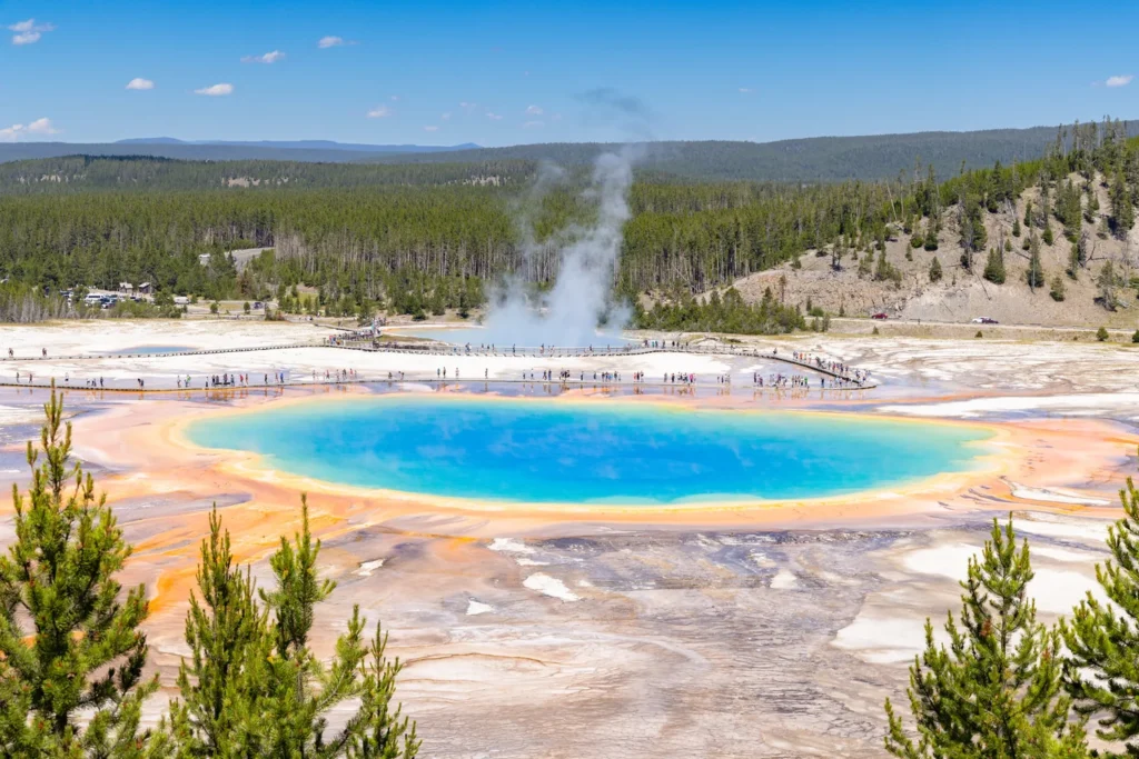
Old Faithful, Grand Prismatic Spring and Norris are separate stops on Yellowstone’s western road network. Even Grand Prismatic Spring has two different approaches: one brings you close to the spring on a boardwalk, and the other gives you the view from above.
Three basins, three different Yellowstone stops
Yellowstone’s main geyser-basin visitor stops are spread along the western park roads.
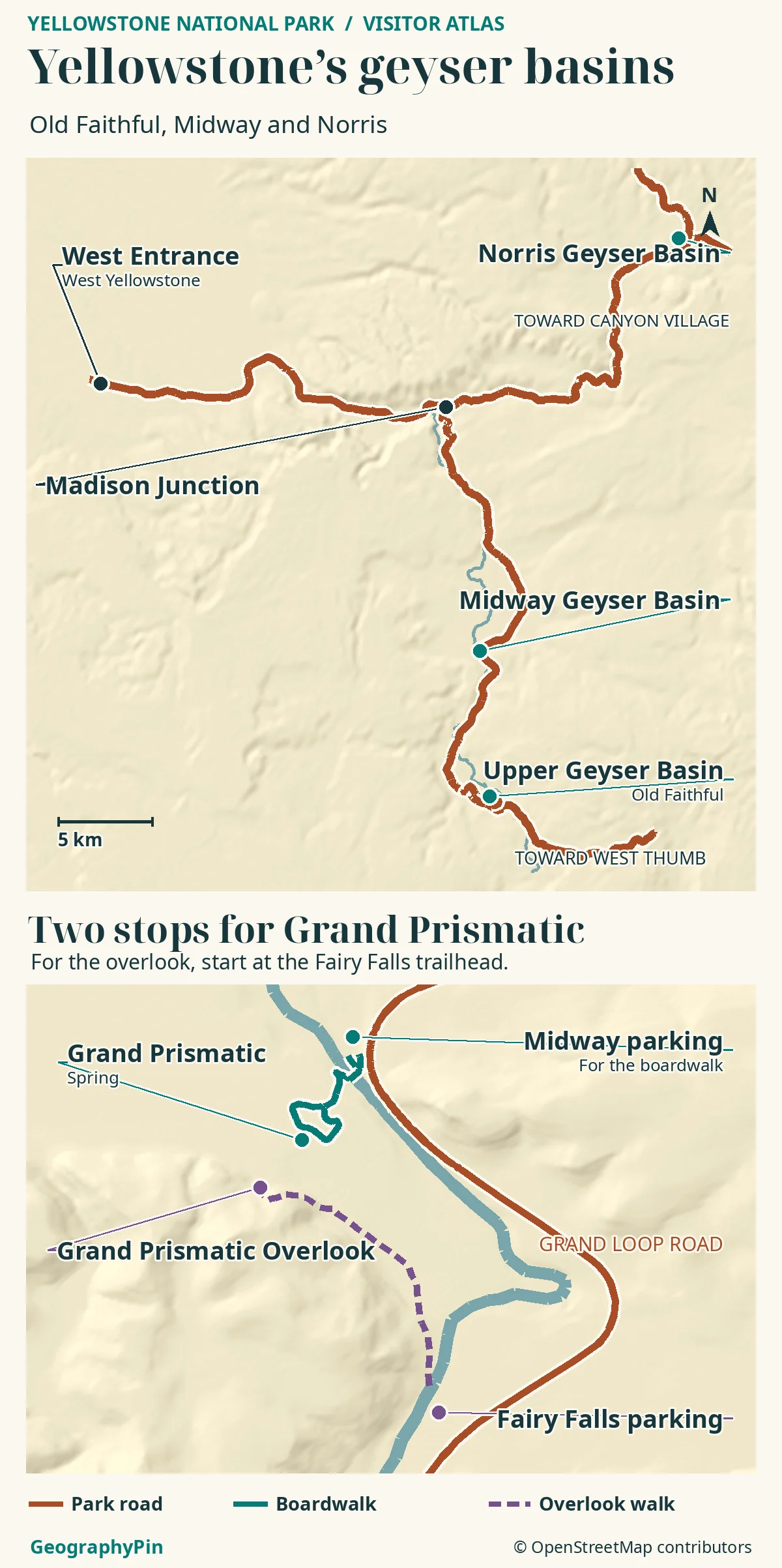
Find Old Faithful in Upper Geyser Basin, Grand Prismatic Spring farther north in Midway, and Norris beyond Madison Junction. Start at the West Entrance when that road is open, or approach Old Faithful from the south via West Thumb.
How to use this article: Start with the comparison table, then compare the Upper Geyser Basin walk with the two Grand Prismatic approaches.
Which part of Yellowstone should you start in?
The West Entrance near West Yellowstone leads east to Madison Junction. From Madison, turn south for Midway and Old Faithful or go north for Norris. From Grand Teton and Yellowstone’s South Entrance, the usual road approach to Old Faithful is through West Thumb and west over Craig Pass. These are routes when the roads are open, not year-round driving instructions.
Choose what you want to see
| If you want to see | Start here | What to allow for |
|---|---|---|
| A geyser eruption and more than one thermal feature | Old Faithful Visitor Education Center, Upper Geyser Basin | Check the predicted eruption window, then leave time for the boardwalks. |
| Grand Prismatic’s colors from above | Fairy Falls Trailhead, south of Midway | Allow for the uphill out-and-back walk. The basin boardwalk uses a different lot. |
| Steaming acidic pools and a different basin landscape | Norris Geyser Basin | Choose open Porcelain Basin or wooded Back Basin without waiting for an eruption. |
Upper Geyser Basin: beyond Old Faithful
Old Faithful is one geyser inside Upper Geyser Basin. Its main viewing area is close to the developed Old Faithful visitor area. Boardwalks and paths continue beside and across the Firehole River, so you can visit other features without moving the car. Geyser Hill is a useful next step if you want to see more of the basin than the single eruption.
Old Faithful is the starting point, not the whole basin
Use the park’s eruption prediction as a planning window, not a fixed timetable. A geyser periodically releases hot water and steam; a hot spring need not erupt, even when steam is visible. Seeing Old Faithful demonstrates one behavior. It does not explain the color and broad surface of Grand Prismatic or how closely packed Norris’s steaming features can be.
Midway Geyser Basin: one spring, two approaches
Grand Prismatic Spring is in Midway Geyser Basin. The main Midway lot gives access to the basin boardwalk, which crosses the Firehole River and goes past the Excelsior Geyser Crater and the spring. From that low angle, steam can hide parts of the pool and its far edge.
Boardwalk or overlook?
For the elevated view often seen in photographs, start at the Fairy Falls Trailhead, which the National Park Service places about 1 mile (1.6 km) south of the Midway lot. That is a road separation between parking areas, not a hiking distance. From Fairy Falls, the overlook is a separate 1.2-mile (1.9-km) round-trip walk with an uphill finish. It is not an extension of the spring-level boardwalk.
If you are choosing between them, use the boardwalk to see the spring’s edge and nearby features; use the overlook to understand the pool’s full outline in the valley. These views complement one another. The overlook is neither a drive-up viewpoint nor the Fairy Falls waterfall itself.
Norris: Porcelain Basin and Back Basin
Norris Geyser Basin is not the next stop directly beside Midway. From the Midway–Old Faithful road, return to Madison and continue north toward Norris. Norris is one of Yellowstone’s hottest hydrothermal areas, and much of its water is acidic. Its two developed sections feel different even though they share a visitor approach.
Porcelain Basin is open and largely treeless, with features visible across the ground. Back Basin is more wooded, and its features are spread out; Steamboat Geyser is here. NPS describes about 0.75 mile (1.2 km) of trail access in Porcelain and a 1.5-mile (2.4-km) route around Back Basin. Those are walking routes, not how far Norris is from another basin. Do not plan around a Steamboat eruption.
The park has other hydrothermal areas, too. Fountain Paint Pot is in Lower Geyser Basin along the western road corridor, and West Thumb has a boardwalk beside Yellowstone Lake. Neither is another name for Norris or Grand Prismatic.
When roads, trails and boardwalks close
Most Yellowstone roads close to ordinary vehicles over winter. The road from the North Entrance through the park toward Cooke City is the principal year-round exception, weather permitting. That exception does not make the roads from Mammoth to Norris or Old Faithful open to your car.
Dated access note: NPS notices checked November 20, 2026, listed most roads closed to all vehicles while the park prepared for the winter season, with designated oversnow routes projected to begin December 15 as conditions allow. That is not the start of private-car access on the western loop. At Biscuit Basin, north of Old Faithful, the park continued to list the parking area, boardwalk and river segment closed following the July 2024 hydrothermal explosion.
Road openings and individual trail or boardwalk access are separate. Use only open designated trails and boardwalks around thermal features. The presence of a road or path on a map does not tell you it is open, and ground near hot springs can be unsafe even when it looks firm.
Frequently Asked Questions
Do driving distances on the park map include the return trip?
No. Read a road distance as the leg between its marked points. If you plan to return along the same road, count that leg again; an explicitly round-trip hiking figure already includes both directions. Do not add the Midway overlook hike as if it were part of the road mileage.
What if Old Faithful is not predicted to erupt soon?
Use the NPS geyser activity page or check the posted estimate at Old Faithful. If the paths are open, visit nearby thermal features first and return with time to spare. The prediction is not an appointment.
Which Yellowstone map should I check before I leave that morning?
Use the NPS live road status map for your entrance and road legs, then Current Conditions for trail or thermal-area notices. Save the official park map for orientation, because a printed road can remain on the map after a closure.
What Did We Learn Today?
Old Faithful anchors Upper Geyser Basin, Midway offers two different ways to see Grand Prismatic Spring, and Norris gives you two walking areas of its own. Choose the basin and then the parking area or trailhead that matches your goal. Driving, walking and winter access are three separate decisions.
Sources & Data Notes
National Park Service visitor geography: Yellowstone maps, Old Faithful and Upper Basin, Midway and Lower basin access, Grand Prismatic Overlook from Fairy Falls, and Norris basin trails. Distances refer to the stated legs and endpoints, not complete daily drives.
Access checked November 20, 2026: NPS current and projected park roads, park notices, and the Biscuit Basin closure alert. See NPS geyser activity for prediction limits. Map: GeographyPin cartography, OpenStreetMap data (ODbL) and AWS Terrain Tiles; not a report of open parking or roads.
Photo: Jacob W. Frank / National Park Service (July 2023), public domain; resized and converted to WebP. AI tools assisted in preparing the article.