West Azerbaijan province is in Iran, not in the independent Republic of Azerbaijan. Its name connects it to a wider regional history, but its administrative borders, communities and provincial capital, Urmia, need to be understood on their own terms.
An Iranian province, not part of the neighboring republic
West Azerbaijan is a province in northwestern Iran, with Urmia as its capital. It is not part of the Republic of Azerbaijan. Its administrative boundary differs from the broader cultural region called Iranian Azerbaijan. Kurdish and Azerbaijani communities live here; the province’s name is not an ethnic census or a claim about every resident.
How to use this article: Compare the similar place names, read about Kurdish communities, or distinguish Lake Urmia from its basin.
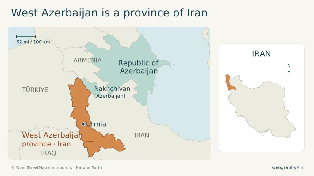
Enlarge map. The Iranian province and independent state are separate places; the Iran inset uses a different scale.
1. Find the province in northwestern Iran
Iran’s official provincial overview places West Azerbaijan against Türkiye and Iraq, with Azerbaijan’s Nakhchivan exclave at its northern edge. Within Iran, its neighbors include East Azerbaijan, Zanjan and Kurdistan. This is a northwestern border province, not simply the western side of the country across the frontier.
The locator highlights the Iranian administrative unit and labels the Republic of Azerbaijan separately, including Nakhchivan. The small Iran inset provides national context at a different scale. Its purpose is to resolve the place-name confusion, not to map ethnic majorities or imply that a border is a cultural dividing line.
Urmia is the provincial capital. English sources may also write the name as Orumiyeh, while West Azerbaijan appears as West Azarbaijan or Azarbayjan-e Gharbi. Keep the kind of place attached to the name: Urmia city, Urmia county and Lake Urmia are different geographic units.
For the larger national setting, see the Iran country profile. The province belongs within that state’s administrative geography, even when a historical text uses a related regional name.
2. Separate the province, the country and the wider region
Four names that answer different questions
| Name | Meaning here |
|---|---|
| West Azerbaijan | An Iranian province with Urmia as capital |
| East Azerbaijan | A separate Iranian province |
| Republic of Azerbaijan | The independent neighboring state |
| Iranian Azerbaijan | A broader historical and cultural regional expression, not one current province |
The Republic of Azerbaijan has its own state institutions and international borders. Calling an Iranian province “West Azerbaijan” does not place it inside that republic, and describing Iranian Azerbaijani communities does not make them citizens of it.
Likewise, a broader cultural region is not a substitute for a provincial boundary. An administrative map answers where one unit ends and another begins; a history of language or community connections may follow a much wider geography.
3. Kurdish and Azerbaijani communities share the province
Kurdish presence is not confined to Kurdistan province
Kurds are part of West Azerbaijan’s population. Pierre Oberling’s scholarly account documents Kurdish communities around Urmia, Mahabad, Sardasht and other western border areas. That historical regional evidence establishes a Kurdish presence beyond the province named Kurdistan; it is not a present-day percentage or a boundary around every Kurdish settlement.
Richard Tapper’s account of Iranian Azerbaijan cautions against treating the wider region as ethnically uniform. It describes Azerbaijani and other communities whose language and settlement histories cross simple regional labels.
The official description of Urmia identifies Azerbaijani Turkish, Kurdish and Persian among the languages used there. This is a multilingual setting, not evidence that every resident uses the same language or identifies in the same way.
A language, an ethnic identification and a place of residence describe different connections. Speaking Persian does not by itself establish Persian ethnicity; living in West Azerbaijan does not establish Azerbaijani ethnicity. The Azerbaijani people and identity explainer develops that distinction across communities beyond the modern republic.
4. Read the population as a dated provincial count
The Statistical Centre of Iran’s selected 2016 census results report 3,265,219 people in West Azerbaijan province. The figure is a provincial population count for 2016, not a current estimate and not the population of Urmia city.
It is also not a count of one ethnic community. The published provincial table used here does not divide that total into Kurdish and Azerbaijani populations. An ethnic share would require separate evidence with an identifiable date, population definition and method; the provincial total cannot supply it.
When comparing figures, keep both labels together: the observation year and the geographic unit. A city can share its name with a larger county, just as a lake basin can extend across provinces. Those different areas can produce different totals without any arithmetic error.
5. Lake Urmia connects more than one province
The city, the lake and the drainage area
Lake Urmia lies between East and West Azerbaijan provinces. The lake is a natural feature, while the provinces are administrative units. Its basin is the wider area draining toward the lake, not another name for West Azerbaijan or for Urmia city.
A 2021 UNDP field report describes work in the Lake Urmia basin across both provinces. In February 2025, UNDP described wetland conservation efforts that connected water-efficient agriculture and more varied livelihoods with reducing pressure on water resources.
That shared basin helps explain why environmental questions extend beyond a provincial boundary. Water use, farming and wetland conservation connect communities across the administrative line. The locator therefore does not attempt to portray a present-day shoreline: a changing water surface requires dated observations of its own.
What Did We Learn Today?
West Azerbaijan is an Iranian province centered administratively on Urmia, not part of the Republic of Azerbaijan. Its Kurdish and Azerbaijani communities cannot be reduced to the province’s name. Read its population as a dated provincial count, and distinguish that administrative area from the city, the broader cultural region and Lake Urmia’s shared basin.
Sources & Data Notes
View provincial, census and map sources
Sources checked November 18, 2026. Population is the 2016 census count, Table 9, not a contemporary estimate. Academic sources provide regional and community context, not current ethnic shares.
Map: original GeographyPin locator using © OpenStreetMap contributors, ODbL, and Natural Earth, public domain. Province geometry uses OSM relation 241593, version 126, retrieved November 18, 2026. Borders are generalized for orientation; no ethnic distribution or current lake shoreline is shown.
- VisitIran: West Azerbaijan provincial geography and languages
- VisitIran: provincial capital and cultural context
- SCI and UNFPA: selected results of the 2016 census, Table 9
- Pierre Oberling, Iranica: Kurdish communities (2004)
- Richard Tapper, Iranica: Iranian Azerbaijan (1988)
- VisitIran: Lake Urmia location
- UNDP: Lake Urmia basin field visit (2021)
- UNDP: Iranian wetlands conservation (2025)