The United Arab Emirates is a country, Dubai is one of its seven emirates, and Dubai city is only part of that emirate. Once those scales are separated, the map becomes clearer: coastal cities face two different gulfs, dunes occupy much of the interior, and rocky mountains rise in the east.
The United Arab Emirates, or UAE, is a federation of seven emirates in southeastern Arabia. Abu Dhabi city is the national capital. Dubai is both an emirate and the name of its principal city, not a separate country. The UAE’s main landscapes include coastal plains, sand deserts, mountain foothills and the Hajar mountain region.
How to use this article: Locate United Arab Emirates in the region, compare its main landscapes, understand the seven emirates, or check dated country facts.
1. Where the UAE Is: Arabia, Two Coasts and Its Neighbors
Locate the country before its cities
The UAE lies in Western Asia on the southeastern Arabian Peninsula. Saudi Arabia and Oman are its land neighbors. Its northern and western shoreline faces the Persian Gulf, commonly called the Arabian Gulf in UAE sources; its eastern shoreline faces the Gulf of Oman.
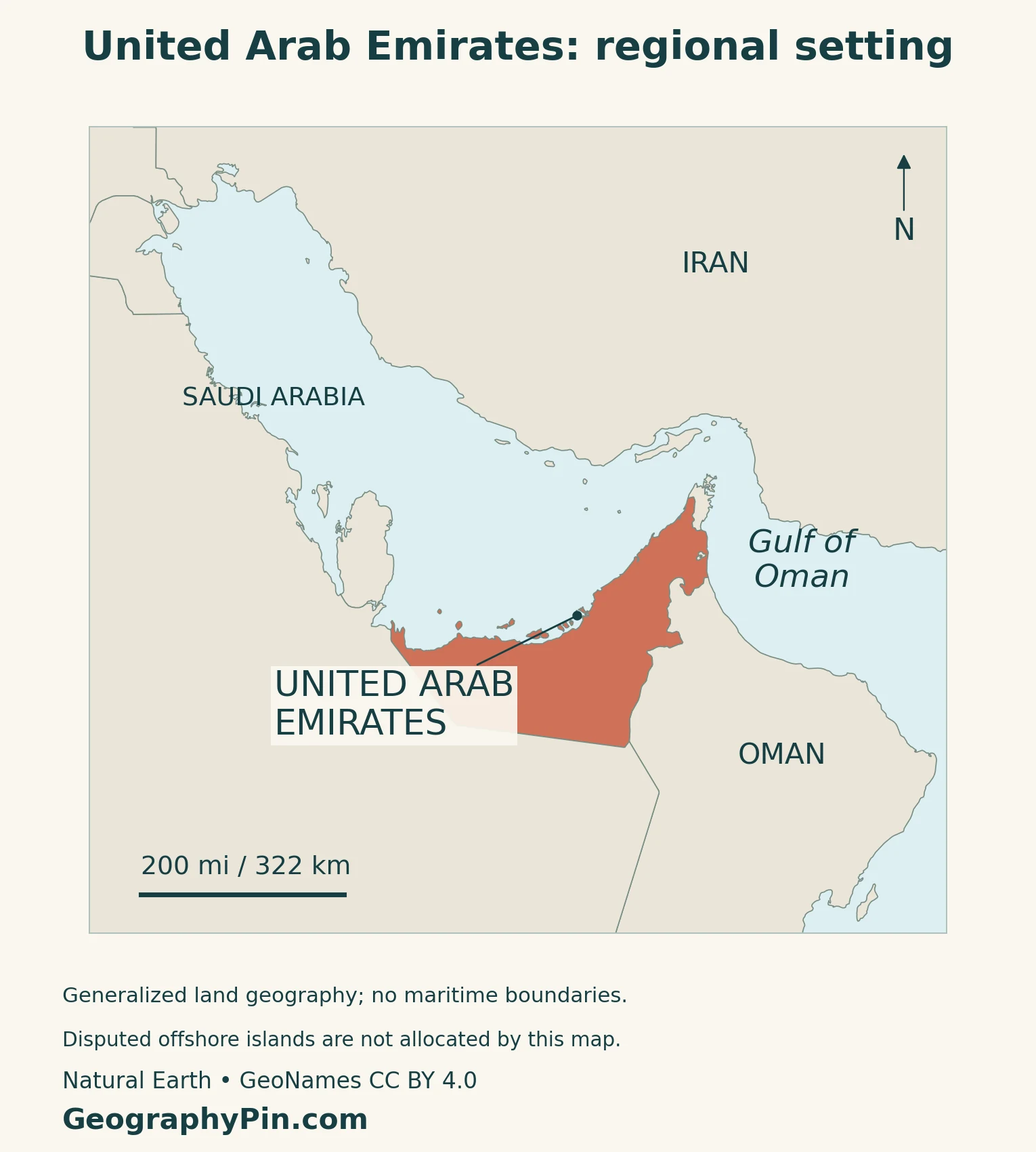
The two gulfs are connected through the Strait of Hormuz, but they are not the same body of water. Fujairah is on the Gulf of Oman side. Abu Dhabi and Dubai face the Gulf on the other side of the peninsula’s northeastern mountain margin.
Oman’s geography makes the northern map more complicated than a single continuous border. Musandam is Omani territory separated from the main body of Oman. Smaller enclaves also require a finer-scale map than a broad country locator can provide.
For the wider regional definition, see the Middle East country guide. The Asia countries and capitals reference places the UAE within its continental context.
2. Seven Emirates: Country, Emirate and City
Dubai is one member of the federation
The seven emirates are Abu Dhabi, Dubai, Sharjah, Ajman, Umm Al Quwain, Ras Al Khaimah and Fujairah. An emirate is a constituent part of the federation, not an additional sovereign country in a list of Asian states.
| Scale | Example | Meaning |
|---|---|---|
| Country | United Arab Emirates | The federation as a whole |
| Emirate | Dubai | One of the federation’s seven constituent emirates |
| City | Dubai city | An urban settlement within Dubai emirate |
| National capital | Abu Dhabi city | The constitutionally named capital, within Abu Dhabi emirate |
City and emirate names often match, which is why references can be ambiguous. A figure for Dubai emirate is not automatically a figure for a narrowly defined urban area. The same caution applies to Abu Dhabi: its city and its much larger emirate are different geographical units.
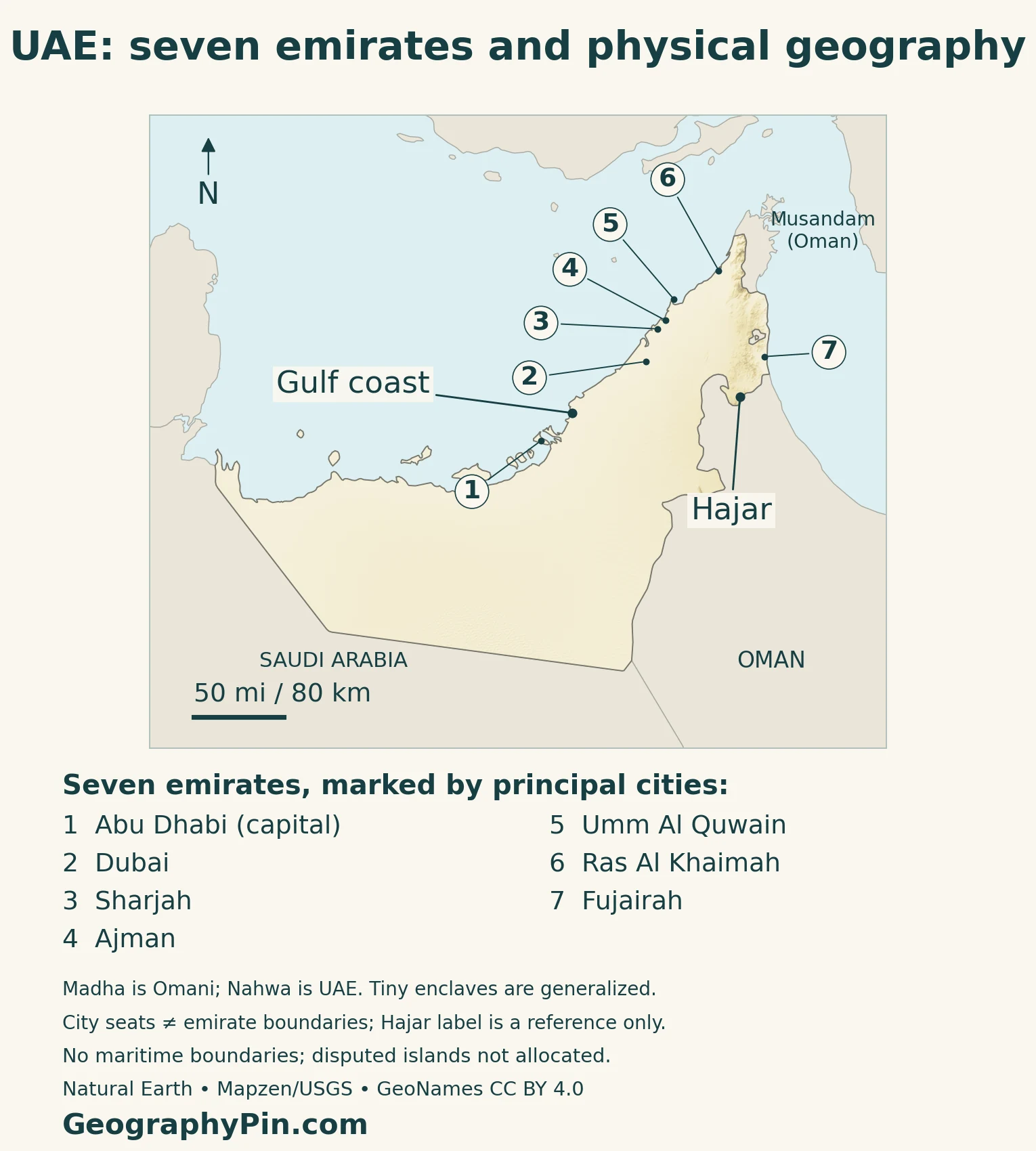
The numbered map key identifies the seven emirates through their principal cities.
Dubai’s skyline is one part of this geography. Our Burj Khalifa guide covers that particular landmark; a building profile is a different task from explaining the federation and its landscapes.
3. Dunes, Mountain Foothills and the Hajar Region
The physical map is not an emirate map
The national climate report describes a landscape that includes sand dunes, oases, rocky mountains, valleys, marshes and salt plains. Desert dominates much of the interior, while the eastern uplands produce a strong contrast in relief.
| Setting | What to look for |
|---|---|
| Coastal plains | Low terrain along the Gulf and Gulf of Oman |
| Sand desert | Dune landscapes across much of the interior |
| Mountain foothills | Gravelly alluvial surfaces beside uplands |
| Hajar mountain region | Rugged relief in the eastern part of the country |
The mountain chain continues into Oman; it is not confined to the UAE. Country boundaries and physical regions answer different questions. The map’s terrain colors show elevation rather than emirate ownership, vegetation cover or the edge of every dune field.
A dry valley is still a drainage feature
Wadis are a characteristic part of the mountain landscape. Rain can send water through channels that are dry at other times. Geographer Gary Feulner distinguishes continuous surface flow along a valley from isolated pools: some Hajar wadis retain freshwater pools even though they are not continuously flowing rivers.
Liwa connects dunes with settlement
Liwa lies in Abu Dhabi emirate at the northern edge of the Rub al Khali, or Empty Quarter. Abu Dhabi’s culture authority describes a chain of settlements and date-palm groves sustained historically by a relatively shallow water table.
The contrast between tall dunes and cultivated oasis land shows that a desert region need not be devoid of people or agriculture. Liwa’s history includes farming, livestock raising and seasonal movement toward coastal pearling activity, linking inland and maritime livelihoods.
4. Climate, Coastal Salt Flats and Mangroves
Heat, rainfall and local contrasts
The UAE has a predominantly hot, arid climate. A 2023 scientific climate synthesis identifies winter and spring as the generally wetter seasons, with higher precipitation near the Hajar Mountains than in much of the desert interior.
Coastal and inland conditions differ, and elevation modifies the mountain climate. The National Centre of Meteorology’s winter explanation describes cooler nights inland and in the highlands, with fog possible under humid, calm conditions. These are broad patterns, not a forecast for a particular trip.
Heavy rain can produce runoff in mountain valleys despite the low annual rainfall characteristic of the country. A dry channel observed on one day therefore does not establish that it stays dry throughout the year.
Not every flat coastline is a sandy beach
Sabkhas are salt-flat environments found along parts of the UAE coast. The national climate report places them alongside mudflats, marshes, seagrass, reefs and mangroves in a wider picture of coastal habitats.
Mangroves occupy intertidal settings rather than inland freshwater forests. The Environment Agency – Abu Dhabi identifies grey mangrove, Avicennia marina, as the dominant local species and describes these habitats as shelter and nursery areas for fish and other wildlife.
Mangrove habitats also store carbon and help reduce coastal erosion. These functions explain why a coastal map should not treat all land between urban areas as ecologically interchangeable. Habitat condition and distribution, however, need their own surveys rather than being inferred from elevation shading.
5. Abu Dhabi, Population and Country Facts
The capital is Abu Dhabi city
Articles 7 and 9 of the Constitution establish Arabic as the official language and Abu Dhabi city as the capital.
| Item | Reference |
|---|---|
| Capital | Abu Dhabi city |
| Population | 11.346 million, UN medium-fertility projection for 2025 |
| Area | About 32,278 square miles (83,600 square kilometers), official government fact sheet |
| Official language | Arabic |
| Currency | UAE dirham (AED), divided into 100 fils |
| Government | Federation of seven emirates |
A national resident total is not a citizenship count
The population figure is the UN’s 2025 medium-fertility projection, not a census count or the latest national statistical release. It covers residents of the UAE, including citizens and expatriate residents. It should not be read as a count of Emirati citizens, or as a population figure for Dubai alone.
Area and political geography need their definitions
The table follows the government fact sheet, not a land-only measure.
The border with Oman also contains small, geographically significant pieces. Nahwa belongs to Sharjah and is surrounded by the Omani enclave of Madha. That nested arrangement is distinct from the larger Omani Musandam peninsula farther north.
At country scale these features are small. The accompanying maps preserve the enclaves present in the source geometry rather than smoothing them into a single solid national outline. Their generalization is documented in the map notes.
6. Oases, Ports and Connections Beyond the Skyline
Al Ain records a long history of oasis settlement
Al Ain lies within Abu Dhabi emirate, away from the national capital’s coastal setting. UNESCO’s Cultural Sites of Al Ain comprise several related places, including Hafit, Hili, Bidaa Bint Saud and oasis areas, rather than a single monument.
Tombs, wells, earthen buildings and irrigation systems provide evidence of long-term settlement in an arid region. The aflaj water-management systems associated with the sites show how the distribution of water supported farming and community organization.
This heritage offers a useful counterpoint to a country description based entirely on recent towers and highways. The UAE’s human geography includes older inland settlements as well as modern coastal cities.
The east coast has a different maritime position
Fujairah’s port is on the Gulf of Oman, outside the Strait of Hormuz. The port authority identifies liquid-bulk handling and storage among its activities. That location differs from ports reached through the strait from the Gulf of Oman into the Persian Gulf.
The geographical distinction is useful without turning the profile into a claim about today’s shipping conditions. Port access, traffic and security can change; the stable point is that the UAE has an eastern maritime frontage as well as its longer Gulf-facing coast.
Frequently Asked Questions
Is Dubai a country?
No. Dubai is one of the UAE’s seven emirates, and Dubai city is a city within that emirate. The country is the United Arab Emirates; its national capital is Abu Dhabi city.
Is the UAE only sand desert?
No. Its landscapes also include rocky mountains, alluvial foothills, coastal plains, salt flats, oases and mangrove habitats. Desert climate does not imply a uniform sandy surface.
What Did We Learn Today?
The UAE is one federation with seven emirates, not seven separate countries. Distinguishing the country, emirate and city makes population figures and maps easier to read. Its dunes, eastern mountains, wadis, oases and coastal habitats also reveal a wider geographical picture than the skylines alone, while Fujairah shows why the two maritime settings matter.
Sources & Data Notes
Population follows the UN’s 2025 medium-fertility projection, a different series from national FCSC estimates; it is not presented as the latest national release, a citizenship count or a city total. Area follows the official government fact sheet and is not relabeled land-only area; different statistical land measures should not be substituted without their definitions. Constitutional references use the amended seven-emirate text. Climate and habitat descriptions are general patterns, not current forecasts, shipping advice or site-specific hazard assessments.
- UNData: 2025 medium-fertility population projection, distinct from national FCSC estimates
- UAE Cabinet: Constitution, amended Articles 1, 7 and 9; federation, language and capital
- UAE First Biennial Transparency Report (2024), pp.159–160: physical settings and coastal habitats
- Gary R. Feulner (2023): Geography and Geology of the UAE; landscape units and wadi pools
- Francesco Paparella and John A. Burt (2023): UAE climate, seasonal and spatial contrasts
- Abu Dhabi Culture: Liwa oasis, groundwater and historical livelihoods
- National Centre of Meteorology via Emirates News Agency, December 22, 2025: winter conditions, fog and wadi runoff
- Environment Agency – Abu Dhabi: grey mangrove habitats and ecological functions; old coverage figures not used
- UAE government fact sheet: area definition and national reference facts; old population figures not used
- UAE Ministry of Foreign Affairs: dirham and fils; old resident counts not used
- Sharjah Tourism: Nahwa within Omani Madha
- Oman tourism: Musandam territorial context
- UNESCO: Cultural Sites of Al Ain, oasis settlement and irrigation
- Fujairah Ports Authority: Gulf of Oman location and liquid-bulk activities
Map method: Original GeographyPin maps use public-domain Natural Earth country geometry and GeoNames city coordinates under CC BY 4.0, selected, reprojected and labeled. Relief uses Mapzen Terrain Tiles and USGS elevation data. The seven numbered dots are principal-city references, not emirate boundaries. The Hajar reference is near Hatta; the Gulf coast reference lies on the source shoreline. All ten source country components are retained, including Nahwa, with the Omani Madha hole and Musandam left outside UAE fill. Tiny enclaves are generalized and require the full-size map. No maritime lines or disputed-island allocation are drawn. These maps do not settle sovereignty over Abu Musa or the Greater and Lesser Tunbs; the UAE letter circulated at the UN in May 2024 records its claim, not a UN adjudication. The feature is a decorative flag-filled outline.