Ukraine’s geography is more varied than a picture of uninterrupted wheat fields suggests. Broad plains and uplands extend between mountain margins and two southern seas, while rivers connect inland cities with agricultural regions and coastal environments. Understanding the country also requires separating its internationally recognized borders from Russian occupation and the uncertain population geography of war.
Ukraine is a European country whose capital is Kyiv. Its geography includes extensive plains, the Ukrainian Carpathians, the Crimean Mountains, the Dnipro basin and Black Sea and Sea of Azov coasts. Crimea and other Russian-occupied Ukrainian territories remain within Ukraine’s internationally recognized borders; a national geographic map is not a map of current military control.
How to use this article: Clarify borders and control, compare the main landscapes, or understand wartime population figures.
1. Locate Ukraine and understand the map
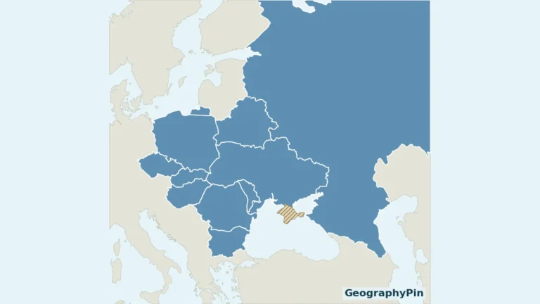
Ukraine borders Poland, Slovakia, Hungary and Romania toward the west and southwest, Moldova to the southwest, Belarus to the north and Russia to the east and northeast. Its southern geographic setting includes the Black Sea and the Sea of Azov. These are descriptions of the country’s recognized territory, not statements about the availability of particular crossings, ports or routes.

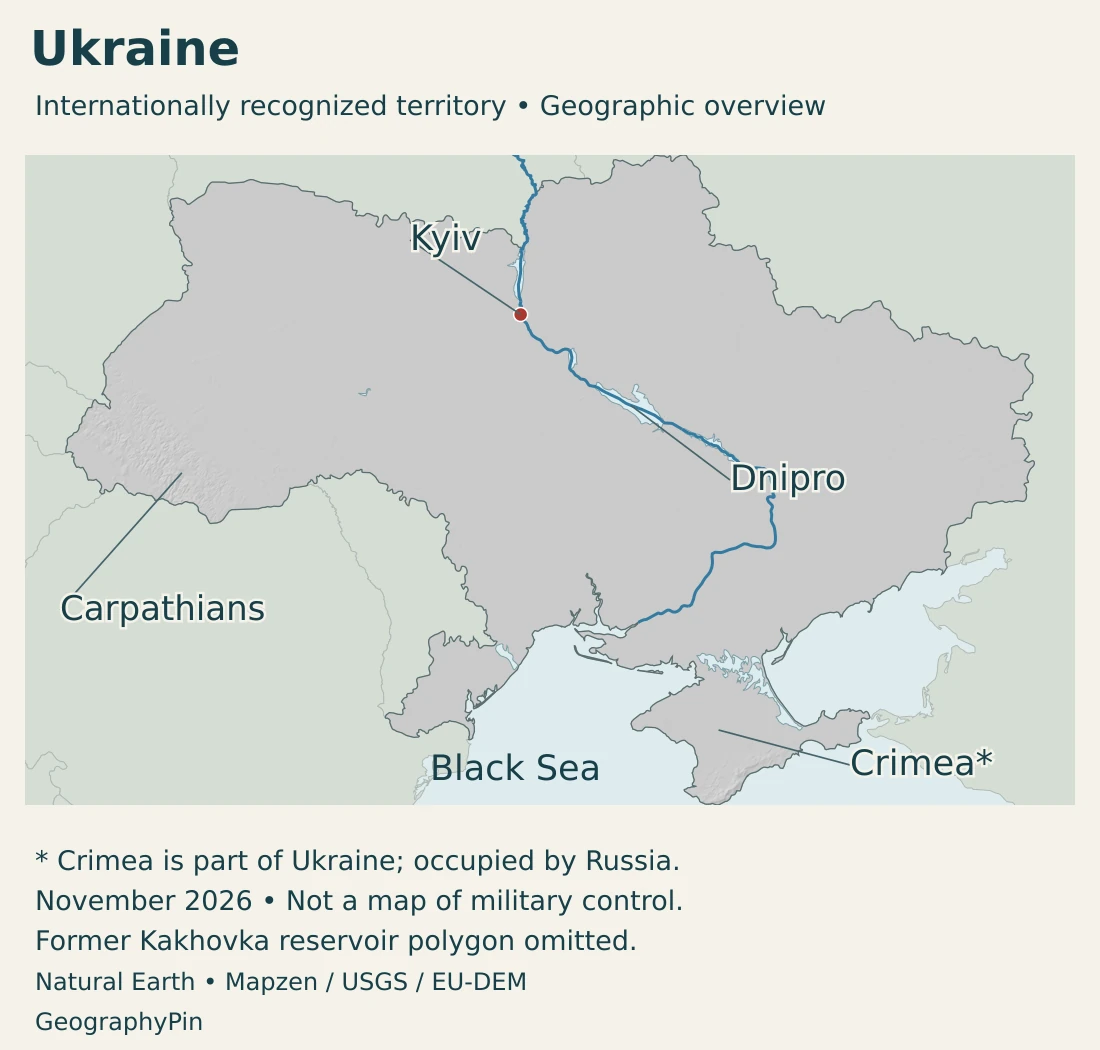
Kyiv is an inland capital on the Dnipro. The Carpathians occupy part of the western margin, while Crimea projects southward between the Black Sea and Sea of Azov. The Crimean Mountains form a separate southern mountain landscape rather than an extension of the Ukrainian Carpathians.
For the wider regional setting, see our Eastern European countries guide and European countries and capitals reference.
International borders are not lines of military control
The UN General Assembly has reaffirmed Ukraine’s territorial integrity within its internationally recognized borders. Its 2014 resolution rejects a change in Crimea’s status based on the referendum held there; its 2022 resolution rejects Russia’s attempted annexation of Donetsk, Kherson, Luhansk and Zaporizhzhia regions. These positions are not equivalent to recognizing the annexation claims.
The UN Secretary-General’s June 2026 report describes Crimea and occupied parts of the four regions as Ukrainian territory temporarily occupied by Russia. Its reporting period is July–December 2025. This profile distinguishes that documented occupation and legal status from the precise, changing location of military control.
The maps here show the country as a geographic whole. They do not trace a live frontline, establish control over individual settlements or indicate safe access. A place can remain legally part of Ukraine while its residents and infrastructure are outside the Ukrainian government’s effective control.
2. Country facts, population and coverage
| Fact | Value | Meaning |
|---|---|---|
| Capital | Kyiv | Constitutional capital. |
| Population | About 38.98 million | UN 2025 medium-fertility projection including Crimea; not a current wartime count. |
| Published surface area | About 233,013 square miles (603,500 km²) | UNData figure, reference year 2023. |
| State language | Ukrainian | Constitutional protections also apply to minority languages. |
| Currency | Hryvnia (UAH) | National currency. |
| Constitutional territorial structure | 24 oblasts, Autonomous Republic of Crimea, and Kyiv and Sevastopol | The two cities have special status; constitutional units are not control zones. |
A projection is not a wartime headcount
UNData publishes a 2025 projected population of about 38.98 million, with a footnote explicitly including Crimea. It is a medium-fertility projection, not a newly conducted census or a count of people currently living in areas controlled by the Ukrainian government.
War makes demographic estimates unusually difficult to interpret. A source may describe a modelled national population, people present in accessible territory, registered residents or refugees in another country. Those categories answer different questions.
Population, displacement and territorial control measure different things. Refugees abroad, internally displaced people and residents of occupied areas cannot simply be added to or subtracted from a national projection without checking its reference date and method. Repeated movements and returns make that arithmetic particularly misleading.
For the same reason, this profile does not calculate a current population density or present a league table of wartime city populations. The national area and the number of people physically present in a particular area are not interchangeable statistical scopes.
3. Plains, mountain margins and coastal landscapes
Compare the main physical settings
| Landscape | Setting | What distinguishes it |
|---|---|---|
| Northern mixed-forest plains | Polissia and adjoining northern lowlands | Forests and lower-lying landscapes contrast with the drier steppe farther south. |
| Forest-steppe and interior uplands | Broad central belt | Cultivated plains, rolling ground and river valleys; not a single perfectly flat surface. |
| Southern and eastern steppe | Toward the southern coastal lowlands and east | More open, generally drier landscapes with extensive agricultural use. |
| Ukrainian Carpathians | Western mountain margin | Mountain slopes and valleys, with elevation strongly influencing local conditions. |
| Crimean Mountains and southern coast | Southern Crimea | Mountain terrain and a narrow coast with Mediterranean climatic influences. |
These are broad physical settings, not administrative regions or maps of current land use. Natural vegetation zones can contain cities, farms, reservoirs and heavily altered landscapes. A steppe zone does not mean that every field remains natural grassland.
Fertile soils do not make the plains uniform
Chernozem, often called black soil, is associated with Ukraine’s forest-steppe and steppe landscapes. Its agricultural importance helps explain the prominence of grain and other field crops. However, soil fertility is not a guarantee of a harvest: moisture, erosion, infrastructure and access also matter.
Gullies and dissected slopes interrupt the plains. Rainfall can move soil downslope, particularly where cultivation leaves the ground exposed. The distinction between a broad low-relief region and a locally level field is important when reading a national terrain map.
Continental climate, with mountain and coastal contrasts
Most of Ukraine has a temperate continental climate. Continental influences generally strengthen eastward, while altitude creates additional differences in mountain areas. The narrow southern Crimean coast has a distinct Mediterranean influence.
The northern forest zone, central forest-steppe and southern steppe also reflect a broad moisture contrast. Local weather can depart substantially from these regional patterns. A mountain valley, an exposed upland and a sheltered coastal site need not share the same conditions simply because they lie within one country.
4. The Dnipro and other river systems
The Dnipro is a basin, a river and a city name
The Dnipro is a major river corridor through Ukraine and the river beside Kyiv. Dnieper is another established English rendering of the same river’s name. Dnipro is also the name of a Ukrainian city, so a city marker and a river label should not be read as the same geographic feature.
A river basin includes the land drained by the main river and its tributaries, not just the channel itself. Water supply, reservoirs, settlement and farming therefore connect places that may be far from the main riverbanks.
The Kakhovka breach changed the lower-river landscape
The destruction of the Kakhovka dam on June 6, 2023 caused severe downstream flooding and loss of upstream water supply. The joint Ukrainian government and UN assessment documented disruption to drinking water, irrigation, energy and river transport.
The former reservoir cannot be treated as an unchanged present-day lake. Older water polygons may preserve its pre-breach outline even when the surrounding map looks modern. Our map’s source notes distinguish generalized river geometry from current water extent.
Not every Ukrainian river belongs to the Dnipro
The Dniester and Southern Bug are distinct from the Dnipro. The Dniester passes through Moldova before returning to Ukraine near the Black Sea. Farther west, Ukrainian Carpathian catchments also feed the Danube system, while Ukraine shares the lower Danube and its delta setting with Romania.
Most Ukrainian river-basin districts drain directly or indirectly toward the Black Sea, but the Western Bug belongs to the Baltic drainage. The Western Bug and Southern Bug are different rivers, despite the shared English name.
A drainage divide is a watershed boundary, not necessarily a mountain crest visible on a small-scale map. It separates runoff toward different river systems. Administrative borders, river basins and physical regions consequently overlap without matching one another.
5. Cities, displacement and languages
Kyiv combines national institutions with an important river location. Other cities occupy different geographic settings: Dnipro lies on its namesake river, Odesa faces the Black Sea, and Lviv lies in western Ukraine. These examples are geographic orientations, not a ranking of their present populations or operating infrastructure.
War changes where people live and work
Russia’s full-scale invasion has displaced people within Ukraine and across its borders. Homes, employment, schools, energy supply and family connections influence where people move and whether they can return. Registered residence and actual presence may therefore differ.
Damage is also uneven. The joint recovery assessment released in February 2026 identifies housing, transport and energy among the most affected sectors, using evidence through December 31, 2025. That dated assessment helps explain settlement pressures without pretending to describe every community’s situation today.
State language and everyday language are different questions
Ukrainian is the state language under Article 10 of the Constitution. The same article guarantees the free development, use and protection of Russian and other languages of national minorities. Legal language status and the languages people use at home are related but different subjects.
Kyiv is the Ukrainian-based spelling used here; Kiev appears in many older English-language sources. Place-name variants should not be mistaken for different cities, and a resident’s preferred language does not by itself determine citizenship or political allegiance.
6. Institutions and economic geography
Ukraine’s constitutional framework provides for national representative institutions and a Cabinet of Ministers as the highest executive body. The prime minister directs the Cabinet’s work. The constitutional territorial structure includes 24 oblasts, the Autonomous Republic of Crimea and the special-status cities of Kyiv and Sevastopol.
These units describe the recognized state’s legal organization. They should not be mistaken for a list of territories under identical practical administration during the war. The hryvnia is Ukraine’s national currency.
Agricultural potential depends on working connections
Ukraine’s cultivated plains support grain and other field crops, but agricultural geography extends beyond soil and climate. Farms need equipment, labor, storage, reliable energy and routes to buyers. Damage to one part of that system can affect production and distribution elsewhere.
Railways, roads, inland waterways and seaports connect producing regions with domestic and overseas markets. Geographic access to a coast is not the same as uninterrupted port operation. Wartime attacks, infrastructure damage and changing access conditions can alter the usefulness of an otherwise established route.
Reconstruction is also a spatial problem
The February 2026 joint recovery assessment places transport, energy, housing, commerce and industry, and agriculture among major areas of reconstruction need. Rebuilding is not simply a matter of replacing structures at the same coordinates: functioning communities also depend on services, connections and people able to live and work there.
This is why Ukraine’s physical and human geography must be read together. Plains and river corridors explain enduring connections, while occupation, displacement and damaged infrastructure change how those connections can be used. Neither a pre-war economic map nor a current military map alone is a complete country profile.
Frequently Asked Questions
Are Dnipro and Dnieper different rivers?
No. They are alternative English renderings for the same river. Dnipro is also a city, so context matters.
Does Ukraine have mountains?
Yes. The Ukrainian Carpathians lie in the west, while the Crimean Mountains form a separate range in southern Crimea. Extensive plains do not mean the country is entirely flat.
Does a map including Crimea show Ukrainian control everywhere?
No. It shows Ukraine’s internationally recognized territory. Russian occupation and current military control are separate from sovereignty; these maps do not chart a live frontline.
What Did We Learn Today?
Ukraine combines extensive plains and uplands with western and southern mountains, major river systems and two southern seas. Its physical geography helps explain agriculture, settlement and transport, but war has profoundly altered access, infrastructure and population distribution. International borders, effective control and statistical coverage must remain distinct.
Sources & Data Notes
Population is the UN’s 2025 medium-fertility projection, explicitly including Crimea, not a current counted resident population. The UN surface-area figure refers to 2023; no separate dry-land or water-area calculation is inferred, and the square-mile conversion is rounded. Internationally recognized territory, effective control and statistical coverage are separate concepts. Political sources were reviewed in November 2026, but their stated reporting periods still apply; no current frontline, territorial-control percentage or live access guidance is supplied.
- PCGN, Ukraine Toponymic Factfile, 2025: Ukrainian-based place names, including Kyiv and the older English form Kiev; historical demographic shares are not used.
- UNData, Ukraine country profile: 2025 medium-fertility population projection, explicitly including Crimea; surface area reference year 2023; currency. Not a current census or a government-controlled-area headcount.
- President of Ukraine, Constitution, Chapter I: Articles 10 and 20: state language, minority-language protections and capital.
- President of Ukraine, Constitution, Chapter VI: Articles 113–114: Cabinet of Ministers and prime minister.
- President of Ukraine, Constitution, Chapter IX: Article 133 constitutional territorial units; not a description of current effective control.
- UN General Assembly, territorial integrity of Ukraine, 2014: Internationally recognized borders and non-recognition of a change in Crimea’s status on the basis of the 2014 referendum.
- UN General Assembly, territorial integrity of Ukraine, 2022: Rejection of the attempted annexation of Donetsk, Kherson, Luhansk and Zaporizhzhia regions.
- UN Secretary-General, report on occupied Ukrainian territories, June 2026: Reporting period July–December 2025; occupation terminology and recognized sovereignty. Not a November 2026 frontline map.
- FAO, Ukraine land and agricultural setting: Plains, mountain margins, chernozem and erosion. Historical economic and agricultural quantities are not current figures.
- FAO, Ukrainian forest and ecological geography: Mixed forest, forest-steppe, steppe and mountain settings; qualitative continental and coastal climate contrasts.
- FAO, Water Report 15: Ukraine: Established regional relief, neighboring countries and river routes. Historical population, water infrastructure and economic statistics are not reused.
- EU4Environment, Ukraine river-basin management: Distinct basin districts and Black Sea versus Baltic drainage; not a current basin-population estimate.
- Government of Ukraine and United Nations, Kakhovka disaster assessment: June 6, 2023 destruction and water, irrigation, energy and transport consequences; assessment released October 2023.
- World Bank and partners, fifth recovery and reconstruction assessment: Released February 23, 2026, covering damage through December 31, 2025; affected sectors and geographic concentration, not today’s totals.
Map sources and scope: Original GeographyPin maps use Natural Earth’s Ukraine-viewpoint country geometry, including Crimea within Ukraine’s internationally recognized territory, with the matching neighboring Russia outline. Natural Earth data are public domain. This convention follows the territorial integrity reaffirmed in UN General Assembly resolution 68/262. It does not imply Ukrainian effective control throughout the depicted territory. No live military-control line, frontline or travel-safety boundary is drawn. November 2026 dates the presentation rather than a boundary survey.
Kyiv uses Natural Earth city-coordinate attributes. The Carpathians and Crimea labels are broad geographic locators, not administrative boundaries. The Dnipro label identifies the river rather than the city. River lines and other lake shapes are generalized historical source geometry, not current channel or shoreline observations.
The obsolete Kakhovka Reservoir water polygon is excluded following the June 2023 dam breach documented in the UNEP environmental assessment. The retained Dnipro source line is not a reconstruction of the post-breach river channel. Elevation data also predate the breach and cannot establish current reservoir-bed or water conditions.
Hillshade is calculated from genuine elevations accessed through Mapzen Terrain Tiles, with no vertical exaggeration. Global elevation data courtesy of the U.S. Geological Survey. Produced using Copernicus data and information funded by the European Union – EU-DEM layers. Elevation-source attribution and terms apply. Relief shading is not bathymetry or numerical elevation bands.
The cover uses Ukraine flag artwork from Commons. The intact flag preserves its 3:2 proportions and appears separately from the decorative outline motif.