Suriname’s geography is built around a striking contrast: a settled Atlantic coastal zone and a much larger, heavily forested interior. Paramaribo stands beside the river that shares the country’s name, while farther upstream the Brokopondo Reservoir connects inland water management with the capital’s electricity supply. Reading the coast, rivers and Guiana Shield together explains more than a forest-cover statistic alone.
Suriname’s population clusters in the northern coastal zone because its capital, established settlements, transport connections and services developed there. River access and colonial-era urban growth reinforced that pattern. The interior has extensive forest, uplands and more dispersed communities, while the low coast offers easier connections but requires careful drainage and flood protection.
How to use this article: Explore the Guiana Shield landscape, understand Brokopondo Reservoir, or check the border-claim context.
1. Where Is Suriname?
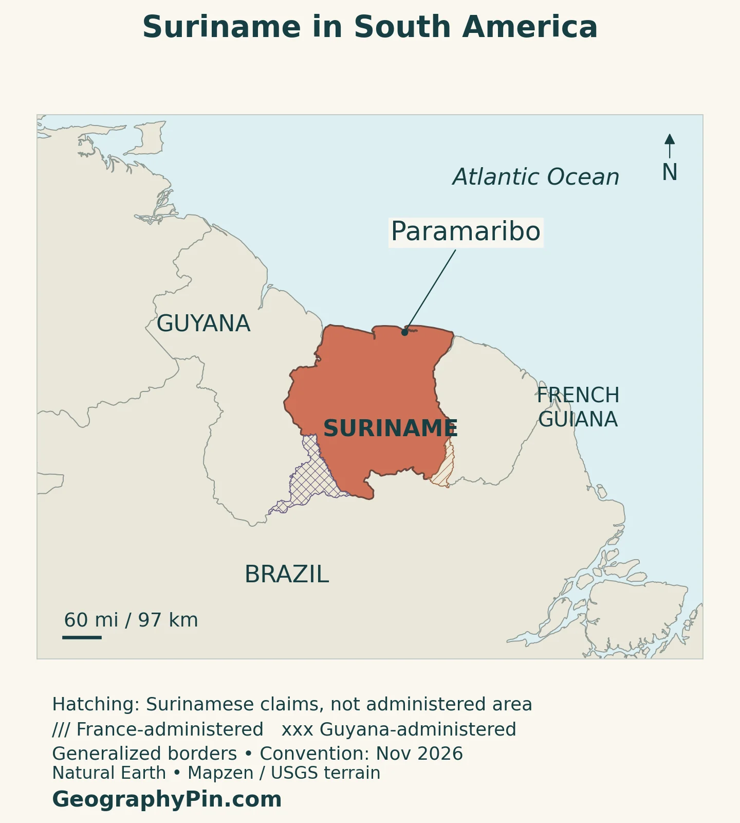
Suriname lies on South America’s northeastern mainland, facing the Atlantic Ocean. Guyana is to the west, Brazil to the south and French Guiana to the east. French Guiana is part of France, not an independent neighboring country. Suriname itself is an independent republic, having become independent from the Netherlands on November 25, 1975.
The Suriname River is a river within the country, not an alternative name for its whole territory. Paramaribo, the capital, occupies its lower course. The broader Guiana Shield extends across national boundaries and describes a physical and geological region rather than a single state.
What the Disputed-Area Hatching Means
The maps distinguish Suriname’s administered outline from claimed territory. Tigri, also called the New River Triangle, is administered by Guyana and claimed by Suriname. The southeastern headwaters dispute concerns different boundary interpretations in the Litani–Marouini area adjoining French Guiana. These are separate disputes and should not be combined into a single border issue.
A French parliamentary report dated June 17, 2026 described the 2021 France–Suriname protocol for downstream border segments while noting that an upstream segment still required negotiation. A signed agreement concerning one stretch therefore should not be read as a settlement of every part of the eastern boundary. Claim markings on these maps identify the issue without presenting Suriname’s claims as foreign territory already under its administration.
2. Country Facts with Dates and Definitions
| Fact | Detail |
|---|---|
| Capital | Paramaribo |
| Population | About 640,000 in 2025, UN medium-variant projected estimate; not a census count |
| Surface area | About 63,251 square miles (163,820 km²), UNData series, reference year 2023; not land-only |
| Official language | Dutch |
| Currency | Suriname dollar (SRD) |
| Government | Independent republic with a president |
| Administrative structure | 10 districts |
The population entry deliberately retains its source and date. A projection estimates a population between or beyond census observations; it is not a new head count. The statistics bureau’s published availability matrix identifies national estimates tied to the 2012 census base and further updates after Census 9. Different releases should not be merged merely because they describe the same country.
The surface-area figure is also a statistical series rather than a measurement of the map’s claim hatching. Land-only totals, surface-area totals and disputed-territory graphics answer different questions. Likewise, Paramaribo district, the historic city and the wider urban area are not identical population units.
3. Four Landscapes from Coast to Interior
A north-to-south reading reveals changes in terrain beneath the forest and settlements. Suriname’s national climate communication distinguishes four broad geographical settings. Their boundaries are gradual landscape transitions, not district borders.
| Setting | Main characteristics | How it differs |
|---|---|---|
| Young coastal plain | Low clay flats, wetlands and sandy shell ridges | Close to the Atlantic, with limited natural relief |
| Old coastal plain | Older clay flats and sandy ridges | An inland coastal landscape with local swampy areas |
| Zanderij or savanna belt | Sandy terrain containing savannas and forest | A transition between coastal deposits and the interior |
| Interior highlands | Hills and uplands of the ancient Guiana Shield | Rockier relief and forested drainage basins |
The Guiana Shield Is Not a Uniform Plateau
The Central Suriname Nature Reserve illustrates the interior’s variety. It includes lowland and upland forests, swamp forest, rocky savanna and granite outcrops. Juliana Top in the Wilhelmina Mountains reaches about 4,035 feet (1,230 meters), the country’s highest elevation. Forest cover can hide these differences on an ordinary outline map, but it does not make the terrain flat.
UNESCO describes the reserve as protecting the upper Coppename watershed and other headwaters. Conservation therefore concerns connected river systems as well as trees and individual species. Water flowing from uplands links habitats at different elevations, making the condition of a drainage basin important beyond a single protected-site boundary.
The reserve also contains archaeological evidence near rivers and creeks. That is a useful reminder that extensive forest should not automatically be interpreted as a landscape without human history. The country’s interior includes inhabited and culturally significant places as well as protected areas.
4. The Suriname River and Brokopondo Reservoir
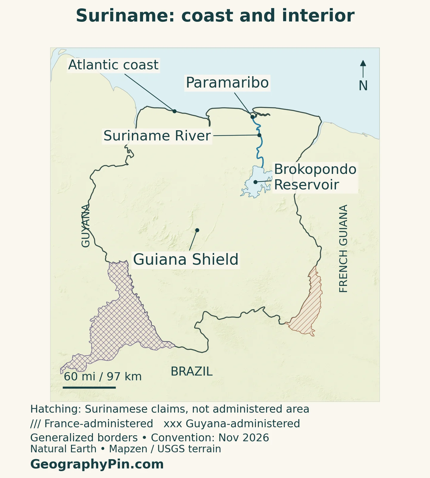
The Suriname River connects an inland watershed with the northern coastal zone. Paramaribo’s location on its lower course makes the river a key reference for understanding the capital. Farther inland, the broad blue shape of Brokopondo on the physical map represents a human-made reservoir, not a naturally formed lake.
A Reservoir That Changed the River
The Afobaka Dam was closed in 1964, impounding the Suriname River and creating the Brokopondo Reservoir. Field research comparing fish communities before and after impoundment documented a major ecological change: a flowing-river environment became a reservoir with distinct open-water and shoreline habitats. The study found that many fish with specialized river-habitat requirements did not persist in the new lake environment.
Today, Staatsolie Power Company Suriname operates the Afobaka hydroelectric facility. Its published installed capacity is 189 megawatts. The company supplies the Greater Paramaribo electricity network through a combination of hydroelectric and thermal generation, so it would be incorrect to describe the capital’s electricity as coming entirely from the reservoir.
Installed generating capacity is not a guarantee of constant output. Hydropower depends on water availability and operation, which makes the river’s seasonal behavior relevant to electricity as well as ecosystems. The reservoir is consequently a useful example of how the forested interior and coastal urban economy are connected, even when they look separate on a population map.
Brokopondo is also a district name. A district boundary, a reservoir shoreline and a river catchment outline would represent three different things. On this map, the label identifies the waterbody rather than assigning the same shape to the administrative district.
5. Rainfall, Wetlands and Coastal Flood Risk
Suriname is warm and humid through the year, with rainfall varying seasonally. The 2023 national climate communication describes a short wet season roughly December–January and a longer one from mid-April to mid-August, separated by drier periods. Movement of the tropical convergence zone helps shape this pattern. These are broad climatic tendencies, not fixed dates on which rain starts or stops.
Coastal wetlands respond to those changing water inputs. The university-supported Suriname Water Resources Information System describes coastal swamps that become fresher during wet periods and more brackish during dry periods. The Nanni swamp is also a source of irrigation water for rice-growing areas. Wetlands therefore are not simply unused spaces between farms and settlements.
Why Coastal Settlement Needs Drainage
Low relief makes it harder to move excess rainfall out of urban areas quickly. Drainage infrastructure must collect water locally and convey it through a connected system. Roads, buildings and expanding settlement change where water can go, while a constricted channel can limit the performance of the larger network.
A World Bank project approved in February 2025 targets drainage upgrades in Greater Paramaribo, emergency preparedness and community resilience. These are planned investments rather than proof that flood risk has disappeared. Their emphasis shows why coastal accessibility and coastal vulnerability are two sides of the same geography.
Heavy rain and a dry-season water shortage are not contradictory possibilities. A place can receive abundant rainfall over a year yet still face problems with its timing, storage, drainage or quality. The distinction is especially important when comparing a city neighborhood, an agricultural wetland and an upstream reservoir.
6. Paramaribo and the Coastal Settlement Pattern
Paramaribo’s historic center developed on the left bank of the Suriname River. UNESCO identifies shell ridges as naturally drained foundations for its main streets and describes later engineering that allowed the city to extend into marshy ground. That history gives a concrete explanation for coastal settlement: access mattered, but so did finding and adapting suitable ground.
The historic center’s street layout and buildings combine Dutch colonial influences with local construction techniques and materials. This is more specific than simply calling Paramaribo a Dutch city transplanted unchanged into the tropics. Its built form reflects adaptation to its South American setting.
The capital’s role in administration, commerce and services reinforces the northern settlement concentration. People and infrastructure are not distributed evenly across the national territory, so a low countrywide population density does not describe the experience of a busy coastal district. Our South American countries and capitals guide places Paramaribo in its wider continental context.
Dutch is the official language and is used in government, education and business. Sranan Tongo and other languages also form part of everyday life. Suriname’s population includes Indigenous peoples and communities with African, South Asian, Javanese, Chinese and other roots; no single language label captures that whole social landscape.
The interior should not be defined only by what it lacks compared with the capital. Its communities, river connections and cultural histories are part of the country’s geography, not blank areas waiting for a city-style development pattern.
7. Government, Resources and Economic Connections
Suriname is a republic with a president and a national legislature. Its districts are administrative divisions, distinct from the four physical settings described above. Paramaribo is the capital, while the national territory extends far beyond the coastal concentration of institutions and services.
Although geographically South American, Suriname also belongs to CARICOM. Its continental neighbors and Caribbean institutions provide different kinds of regional connection. Nearby Guyana offers another example of a mainland country with strong Caribbean ties, though the two countries have different colonial and linguistic histories.
Mining and petroleum are central to Suriname’s economy, and their importance makes commodity prices consequential for public finances and exports. Coastal services, inland resource activities and energy infrastructure are linked, but they do not occupy the same locations or distribute benefits in the same way.
The World Bank’s current overview describes offshore projects progressing toward production expected in 2028. That is a future timetable, not evidence that the anticipated offshore output was already being produced in November 2026. It is also distinct from Suriname’s established petroleum operations.
Resource development has to be understood alongside water management and the forested interior. A large national export figure does not by itself explain local access to services, the condition of a river or the effect of a project on a community. Those questions require looking at where activity takes place and which landscapes and people it connects.
What Did We Learn Today?
Suriname’s coastal concentration reflects settlement history, river access and the growth of Paramaribo, while the Guiana Shield gives the interior a varied forested landscape. Brokopondo links inland water and energy with the coastal economy. Accurate maps distinguish reservoirs from natural lakes, districts from physical regions, and territorial claims from administration.
Sources & Data Notes
Population is a UN medium-variant projection for 2025, not a newly published census result. Area follows the UNData 2023 surface-area series. The 2023 national climate communication supplies stable landscape and seasonal context; future offshore production is an expectation, not current output. The French boundary report is dated June 17, 2026; its statements about ratification refer to that date. Map conventions were reviewed November 16, 2026.
- UNData: population projection, surface area and currency
- General Bureau of Statistics: demographic data availability and census bases
- Government of Suriname: capital, independence, language and regional affiliations
- Official Gazette 2025 No. 15: consolidated constitution
- Official Gazette 2025 No. 26: electoral regulations and district structure
- Government of Suriname: Third National Communication, 2023, physical regions and climate
- UNESCO: Central Suriname Nature Reserve and Guiana Shield landscapes
- UNESCO: historic Paramaribo, river setting and urban development
- Mol and colleagues, 2007: Brokopondo fish communities before and after impoundment
- Staatsolie: Afobaka and the electricity supply system
- Suriname Water Resources Information System: coastal wetlands and irrigation
- World Bank: February 2025 drainage and community-resilience project
- World Bank: economic overview and expected offshore development timetable
- French National Assembly: June 17, 2026 report, eastern boundary discussion
- Guyana Ministry of Foreign Affairs: February 2025 statement on Tigri
Map method: Original GeographyPin cartography uses public-domain Natural Earth country outlines, Paramaribo point, rivers, lakes and claim polygons. Brokopondo is a reservoir, and the Guiana Shield label is a broad reference rather than an exact geological boundary. Tigri and Lawa-headwaters claims are hatched separately without enlarging Suriname’s administered fill; generalized borders do not resolve treaty-scale river islands or maritime boundaries. Relief uses Mapzen Terrain Tiles with USGS SRTM/GMTED2010 elevation; seven negative inland source cells were replaced with original neighboring valid-cell medians for rendering only. Elevation colors do not classify vegetation. The featured image is a decorative flag-filled administered outline, not a legal boundary determination.