South Africa is more than the southern end of an outline of Africa. Roads from the coast climb toward a high interior, mountain catchments feed rivers across national borders, and major cities serve different economic and government roles. Understanding those connections makes both its landscape and its often-confusing capital-city question much easier to read.
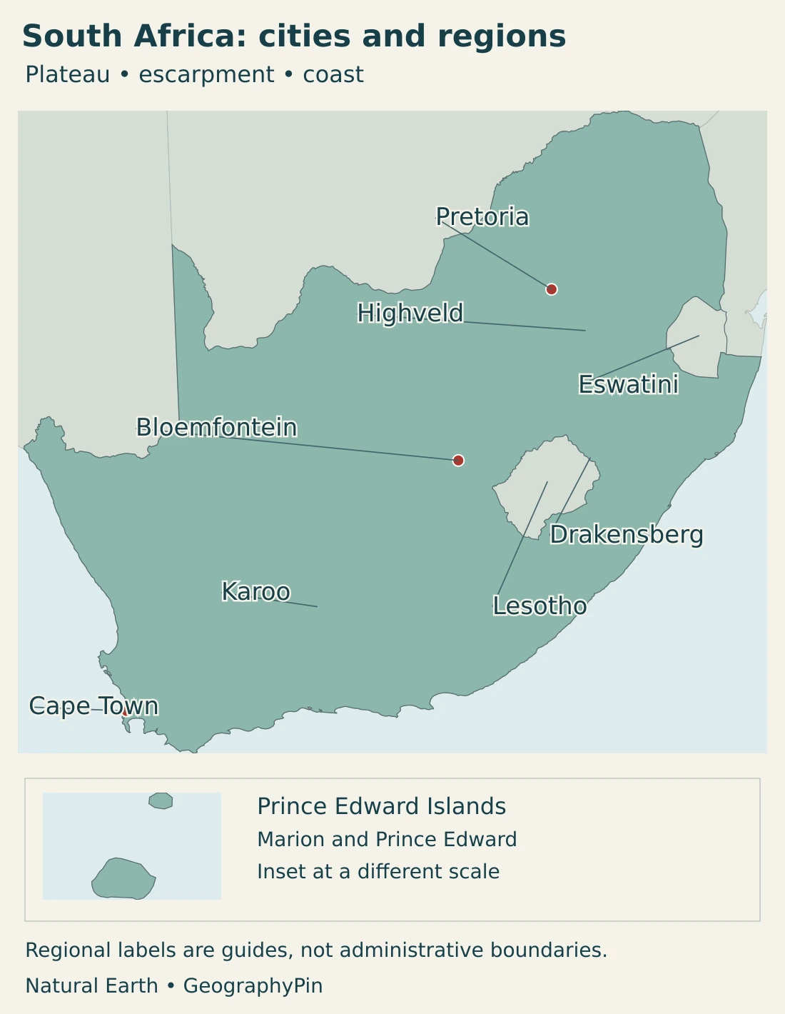
South Africa occupies the continent’s southern end, with Atlantic and Indian Ocean coasts and a broad interior plateau. The Great Escarpment separates much of that high interior from lower coastal terrain. Pretoria is the administrative capital, Cape Town hosts Parliament, and Bloemfontein hosts the Supreme Court of Appeal; the Constitutional Court is in Johannesburg.
How to use this article: Resolve the capital-city question, compare the main landscapes, or follow the cross-border river systems.
1. Locate South Africa and read its map
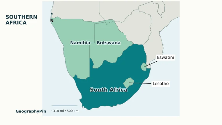
The Republic of South Africa lies at Africa’s southern tip. Namibia and Botswana are to its north and northwest, Zimbabwe lies farther northeast along the northern boundary, and Mozambique and Eswatini border its northeastern side. Lesotho is completely surrounded by South Africa, but it is a separate sovereign country, not a South African province.
Eswatini is also independent, but unlike Lesotho it has a border with Mozambique. These distinctions matter on a small map: a country enclosed by another country does not cease to be independent, and a neighboring state should not inherit the surrounding country’s map color.
Cape Agulhas is the southernmost point of the African mainland. Cape Town and the Cape Peninsula lie farther northwest; Cape Point is not the continent’s southern tip. South Africa also has the remote subantarctic Prince Edward Islands, consisting of Marion Island and Prince Edward Island. They belong to the country but are far from its continental coast.
South Africa is one country within the broader region of Southern Africa. The regional name can follow different geographic or organizational definitions; it is not an alternative name for the republic.
2. Country facts and the capital-city question
| Item | Fact and scope |
|---|---|
| National government seats | Pretoria: administrative; Cape Town: Parliament; Bloemfontein: Supreme Court of Appeal. Constitutional Court: Johannesburg. |
| Population | About 63.52 million, mid-2026 estimate; not a census count. |
| Area | About 471,359 sq mi (1,220,813 km²), land surface reported by the government overview; the source gives no survey year. |
| Currency | South African rand (ZAR). |
| Official languages | 12, including South African Sign Language; see the language section below. |
| Administrative geography | Nine provinces; national, provincial and local spheres of government. |
The area is the government overview’s reported land-surface figure, not a measurement of the map image or a total including maritime zones. Other references may use different area conventions; no population density is calculated by mixing these measures.
A census count records a population at its census reference date. A mid-year estimate updates the demographic picture using a statistical model and demographic evidence. Those figures answer related but different questions, so an estimate should retain its year rather than be described as a new census.
What do the different capital cities actually do?
The familiar “three capitals” description is useful if the functions are stated. Pretoria is the administrative center, Cape Town is the seat of Parliament, and Bloemfontein is associated with the judiciary through the Supreme Court of Appeal. They are not three identical centers sharing every national institution.
The divided arrangement has historical roots in the compromise that accompanied the creation of the Union of South Africa in 1910, then a white-minority state. Different centers retained major state functions. Today’s constitutional institutions give that inherited pattern a more specific meaning than a simple list of three equal capitals.
There is an important fourth city in the court geography: Johannesburg is home to the Constitutional Court. Calling Bloemfontein the judicial capital does not mean that every highest national court sits there. Johannesburg’s economic importance also does not make it the administrative capital.
City names and metropolitan municipalities are different units. Pretoria lies within the City of Tshwane municipality; Bloemfontein lies within Mangaung. A metropolitan population can cover settlements and land beyond the city named in a capital list, so city and municipal totals should not be mixed.
3. Plateau, escarpment and coastal landscapes
Reading the country from the interior toward the sea
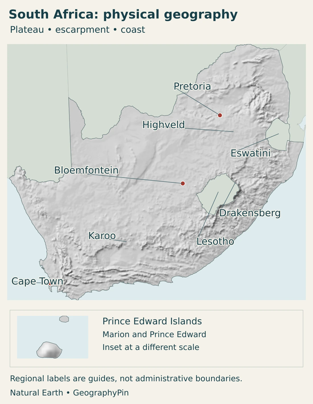
A useful starting point is the contrast between the elevated interior and the lower terrain toward the coast. The Great Escarpment marks much of the transition, but it is not a single straight cliff or a uniform mountain wall. Valleys, slopes and different rock formations create a much more varied landscape.
| Setting | Landscape and position | Connection to the wider country |
|---|---|---|
| Interior plateau and Highveld | Elevated inland plains and rolling terrain, with extensive grassland environments | Includes major inland settlement and industrial areas; elevation distinguishes it from warmer lowlands |
| Great Escarpment and Drakensberg | Steep transitions and mountain landscapes, particularly prominent in the east | Connect upland catchments with lower valleys; the mountain environment continues across the Lesotho boundary |
| Karoo | Dry interior landscapes with plains, hills, plateaus and exposed rock layers | A broad regional name, not a single province or one uniform vegetation type |
| Cape mountain and coastal landscapes | Folded mountain belts, valleys and coastal lowlands in the southwest and south | Include Cape Town’s mountain setting and distinctive winter-rainfall environments in the southwest |
| Eastern lowlands and coast | Lower terrain toward Mozambique and the Indian Ocean, with warmer coastal settings | Link inland routes and river systems with coastal cities and ports |
The Highveld is a geographic landscape term rather than the name of a province. Its high grassland environments contrast with lower savanna settings toward the north and east. Provinces such as Mpumalanga cross these transitions, so a provincial boundary is not necessarily the edge of a climate or vegetation zone.
The Drakensberg’s cliffs and highlands are equally poor candidates for a simple national division. The Maloti-Drakensberg World Heritage property spans protected landscapes in South Africa and Lesotho. Its basalt buttresses, sandstone formations and steep valleys illustrate how geology and erosion produce a landscape that continues across the international boundary.
In the Karoo, horizontal-looking rock layers and isolated hills can make the landscape appear deceptively simple. Karoo National Park provides a concrete example: alternating sedimentary beds and more erosion-resistant dolerite intrusions help form contrasting slopes and sharp-edged higher ground. That local geological explanation is more useful than imagining the whole region as featureless desert.
South Africa’s southwest has a different mountain setting. Cape mountain belts and coastal basins do not simply repeat the Highveld landscape. Our separate Table Mountain guide explains the sandstone landmark beside Cape Town in more detail.
4. Climate, rivers and living landscapes
Rainfall season and elevation change the picture
“South African weather” is not one climate. Much of the interior receives most of its rain in the warmer part of the year, while the southwestern Cape has a winter-rainfall pattern. Parts of the southern coast receive rain through the year. These seasonal contrasts matter as much as a countrywide annual average.
Height also matters. The inland plateau can experience cold winter nights even though the country lies well south of the equator in broadly subtropical latitudes. Coastal conditions are moderated by the ocean, while exposed mountain sites can differ sharply from nearby valleys. A coastal forecast is therefore a poor substitute for conditions on the Highveld or in the Drakensberg.
Offshore, the cold Benguela system influences the west coast, while the warm Agulhas Current runs along the eastern side. These are moving ocean systems, not a visible seam where two colors of water meet. Their effects interact with atmospheric circulation and relief rather than providing a single explanation for every local climate.
The Orange–Senqu and Limpopo cross national borders
The Orange–Senqu basin links the Lesotho highlands with central and western South Africa and parts of Namibia and Botswana. The main river is called the Senqu in Lesotho and the Orange farther downstream. Its drainage setting ranges from wet mountain headwaters to much drier country, so the place receiving water can be very different from the place where that water first fell as rain.
The Orange flows toward the Atlantic, with the Vaal forming an important tributary system. The Limpopo represents a different cross-border network, shared by South Africa, Botswana, Zimbabwe and Mozambique. Its basin descends from plateau and upland settings toward Mozambique’s low coastal plain and the Indian Ocean. These are drainage basins, not extra administrative regions.
Mountain catchments, reservoirs, demand in cities and irrigation areas all belong to the same water story. The existence of a river line on a map does not show how much water is available at a particular time or how that supply is shared. Seasonal conditions and upstream uses remain important even far from an international border.
Beyond the image of one savanna landscape
Grasslands, savannas, dry Karoo vegetation and Cape fynbos should not be treated as interchangeable scenery. Savanna combines a grassy layer with woody vegetation, while the high interior includes extensive grassland settings. Temperature, rainfall, soils and disturbance help shape their distribution.
The Cape Floral Region is especially distinctive. Its fynbos shrublands contain many plants found nowhere else and are adapted to a Mediterranean-type climate and periodic fire. That does not mean every fire is harmless: an ecosystem’s relationship with fire is more complex than the presence or absence of flames. The region is a reminder that South African biodiversity includes far more than large mammals.
5. People, cities and languages
Settlement is strongly uneven. Gauteng is the smallest province by area but a dense urban and economic center, whereas the much larger Northern Cape has a far more dispersed settlement pattern. A broad national outline can conceal this contrast: a relatively compact inland city-region and a vast dry province are not comparable simply because both are colored as single units.
Pretoria and Johannesburg are neighboring centers within Gauteng, but they serve different functions. One is central to national administration; the other is a major business center. Cape Town combines parliamentary functions with a coastal metropolitan economy, while Durban connects a large east-coast urban area with port activity.
A city marker is only an orientation point. It cannot represent an entire commuting region, metropolitan municipality or pattern of access to employment and services. Regional population comparisons are most useful when they use the same date and the same type of boundary.
Official languages are not a single home-language pattern
South Africa recognizes 12 official languages: Afrikaans, English, isiNdebele, isiXhosa, isiZulu, Sepedi, Sesotho, Setswana, siSwati, Tshivenda, Xitsonga and South African Sign Language. Sign-language recognition belongs in the same legal list; it should not be left out by reusing the older eleven-language count.
Language use varies between provinces, communities and individual households. A person can use one language at home and another in education, work or public administration. An official-language list describes legal recognition; it does not mean every resident speaks every listed language or that each province has one exclusive language.
6. Government and the geography of the economy
South Africa is a constitutional republic. Its national Parliament comprises the National Assembly and the National Council of Provinces. The National Assembly chooses the President; the National Council of Provinces represents provincial interests in the national legislative process. National, provincial and local government are distinct but interdependent spheres, not separate sovereign states.
The economy has a strong geographic pattern rather than one industry spread evenly over the country. Gauteng’s inland urban network concentrates business services, manufacturing, trade and logistics. Mining districts, farming areas and coastal ports serve different roles, connected by transport and energy infrastructure.
The country’s resources are important, but “a mining economy” is an incomplete description. Financial and business services in Gauteng, industrial activity on the Highveld, and port-related activity on the east coast are different kinds of concentration. Their locations reflect accumulated infrastructure and urban development as well as physical resources.
The contrast between an elevated industrial interior and seaports helps explain why transport links matter. Moving goods between production areas and the coast requires connections across long distances and changing terrain. Physical geography creates opportunities and constraints; it does not determine prosperity or access to services on its own.
Frequently Asked Questions
Does South Africa have three capitals?
It is conventionally described that way: Pretoria is administrative, Cape Town is legislative, and Bloemfontein is judicial through the Supreme Court of Appeal. The Constitutional Court is in Johannesburg, so the three-city shorthand does not describe every national court.
Is Lesotho part of South Africa?
No. Lesotho is a sovereign country entirely surrounded by South Africa. Its border is international. Eswatini is also independent, but it borders both South Africa and Mozambique.
Is all of South Africa hot and dry?
No. Elevation, rainfall season, distance from the sea and regional circulation produce major contrasts. The inland plateau, southwestern winter-rainfall area, eastern lowlands and high mountains do not share one climate.
What Did We Learn Today?
South Africa’s high interior, escarpment and contrasting coasts form the physical framework for its rivers, climates and settlement. Government functions are divided among cities, while metropolitan and provincial boundaries describe different geographic units. Lesotho and Eswatini remain independent neighbors, and shared river basins connect the country to a wider region. Reading those distinctions together gives a clearer picture than treating South Africa as one landscape, one capital or one economy.
Sources & Data Notes
- South African government country overview: Reported land surface, currency, capital functions and current official-language list; the area entry has no survey year.
- Statistics South Africa, Mid-year Population Estimates 2026: 2026 estimate rounded to 63.52 million, also reproduced by the Eastern Cape Provincial Treasury.
- Eastern Cape Provincial Treasury: Official corroboration of the rounded national mid-2026 population estimate.
- South African government, provinces: Nine provinces, metropolitan distinctions and regional geography.
- Department of Justice, Superior Courts Act: Sections 4 and 5 identify the seats of the Constitutional Court and Supreme Court of Appeal.
- Department of Justice, Constitution: Parliament: Parliamentary institutions and Cape Town’s role under section 42.
- Constitution: co-operative government: Section 40 distinguishes national, provincial and local spheres.
- Nelson Mandela Foundation, The Presidential Years: Historical origins of the divided-capital arrangement and later debate over Parliament’s location.
- Government geography and climate overview: Broad plateau, escarpment, coast and ocean-current setting.
- SANParks, Cape Agulhas: Southernmost point of the African mainland.
- SANParks, Karoo geology: Sedimentary rocks, dolerite and contrasting erosion in Karoo National Park.
- UNESCO, Maloti-Drakensberg Park: Cross-border mountain landscapes and geological character.
- UNESCO, Cape Floral Region: Fynbos, endemism and ecological adaptation.
- SANBI, Ecosystem Guidelines for the Savanna Biome: Highland grassland versus lower savanna settings and vegetation structure.
- Du Plessis and Kibii, South African rainfall research: 2021 study; regional summer, winter and all-year rainfall patterns, not a current weather forecast.
- ORASECOM, Orange–Senqu basin: Shared basin geography across four countries and contrasting upstream and downstream landscapes.
- South African Tourism, Vaal River: Vaal–Orange connection and Atlantic drainage.
- LIMCOM, basin landscape: Four-country basin and transition from plateau to Mozambique’s lowlands.
- Parliament, Gauteng provincial profile: October 2025 reference for urban structure, terrain and economic sectors; no current GDP share inferred.
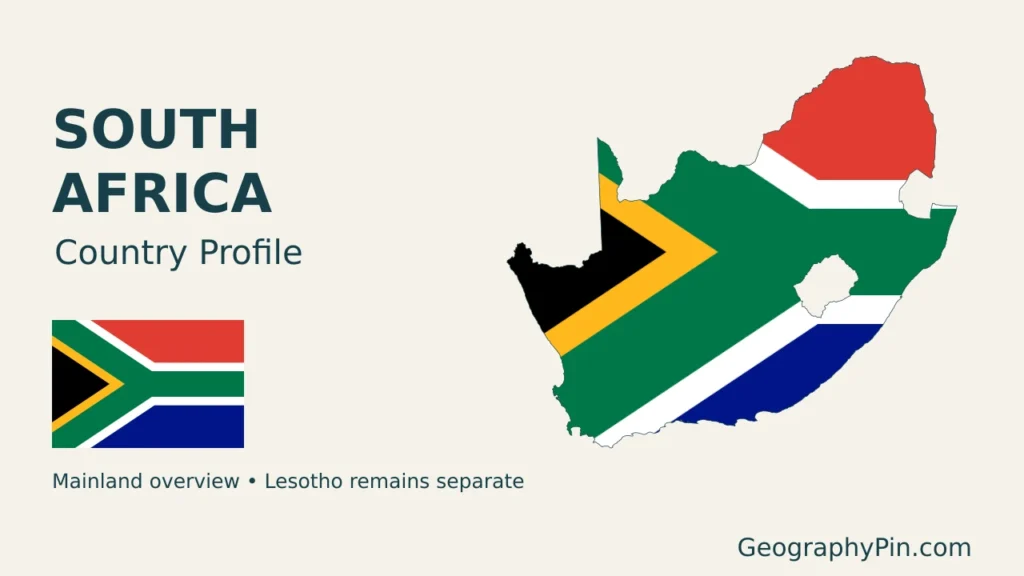
Map sources and scope: Original GeographyPin compositions use public-domain Natural Earth country and city geometry and its actual shaded-relief raster. The article maps include the mainland, Marion Island and Prince Edward Island. The cover is explicitly mainland-only; its outline excludes Lesotho.
The mainland map uses a Lambert azimuthal equal-area projection centered at 29°S, 25°E. The Prince Edward Islands are separately projected and enlarged in a framed inset, not shown beside the mainland at their real relative distance or at the same scale. Lesotho and Eswatini remain distinct sovereign neighbors. Generalized outlines may omit small coastal details.
City dots mark selected locations, not complete metropolitan areas or all national court seats. Highveld, Drakensberg and Karoo labels identify broad geographic settings rather than surveyed regional boundaries. Relief shading depicts terrain form, not numeric elevation classes. The national flag appears in the original cover composition with an intact flag alongside the decorative outline. GeographyPin branding identifies the original artwork.