Solomon Islands is an island country, but its geography cannot be reduced to one island chain or one kind of island.
Solomon Islands is a sovereign country in the southwestern Pacific, with Honiara on Guadalcanal as its capital. Mountainous islands, coral settings and distant eastern islands form a scattered state. The geographic Solomon archipelago also includes Bougainville in Papua New Guinea, so the archipelago and the country are not identical.
How to use this article: Locate the country on the map, read the physical map, explore seasonal climate, or check the population reference.
1. Locate the Country and Define Its Island Scope
The country is not the entire geographic island chain
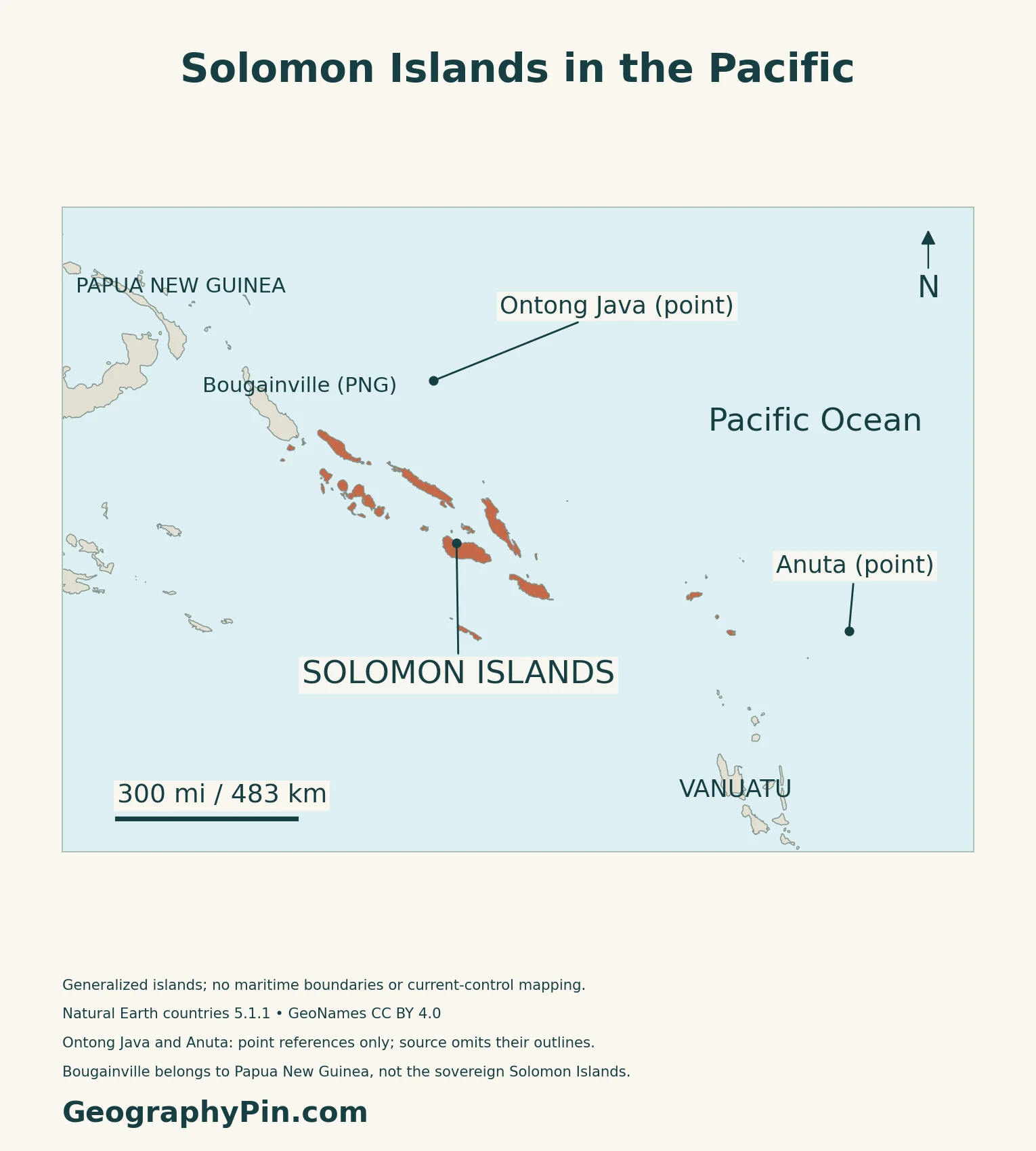
Solomon Islands is an archipelagic state in the southwestern Pacific region of Oceania, east of Papua New Guinea and northwest of Vanuatu. The geographic Solomon island chain extends beyond the country: Bougainville is part of that chain but remains an autonomous region of Papua New Guinea.
As of November 2026, Papua New Guinea’s Parliament was considering the outcome of Bougainville’s independence referendum. The referendum did not itself create an independent state.
Honiara is on Guadalcanal, but administratively separate
Honiara is the national capital on Guadalcanal. It is administered by its own city council rather than as part of Guadalcanal Province.
2. Compare Mountainous Islands and Coral Landscapes
The islands do not share one landform
| Setting | Examples | Geographic distinction |
|---|---|---|
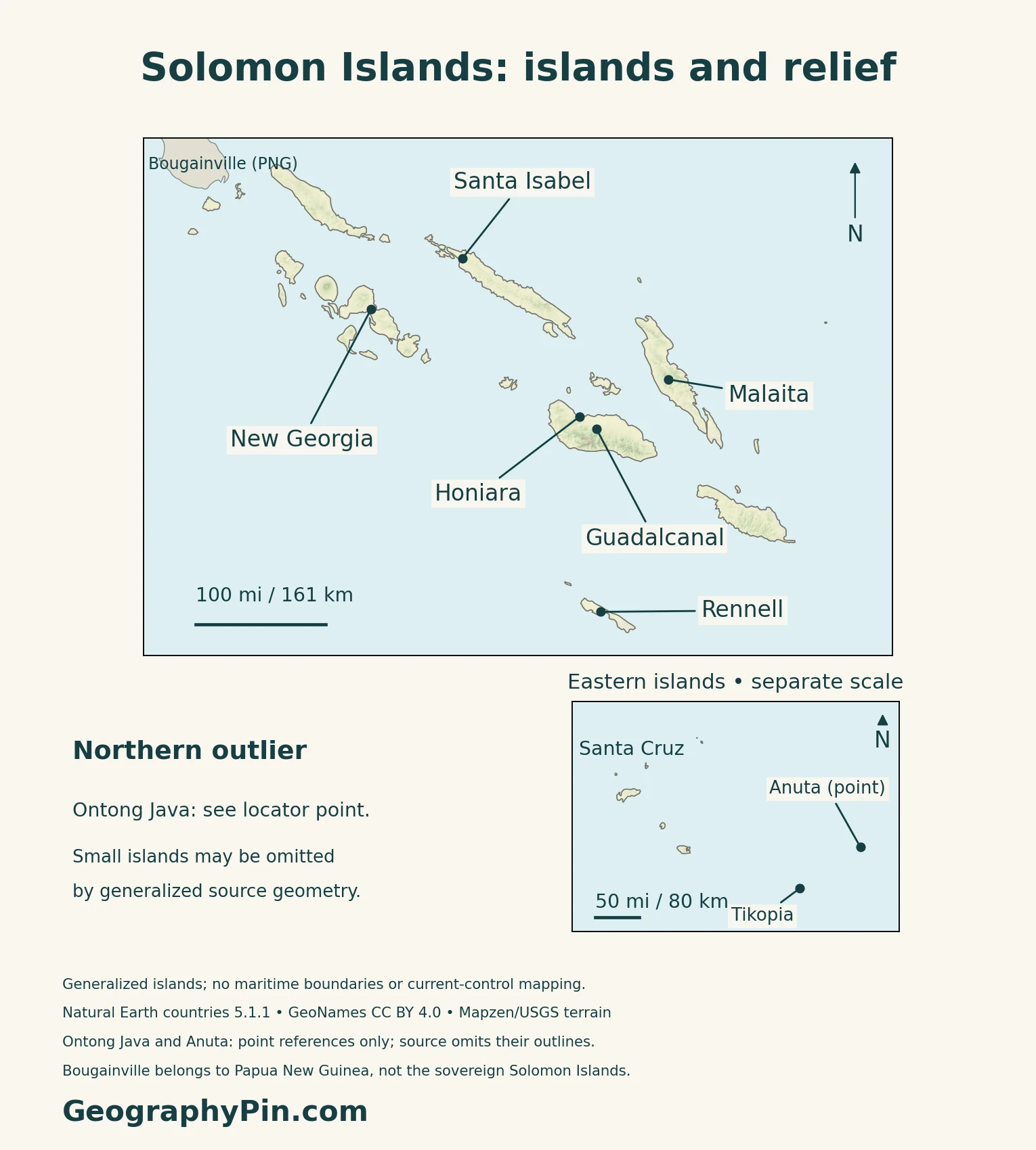
| Large mountainous islands | Guadalcanal, Malaita, Santa Isabel and New Georgia | Relief and coastlines differ within the main group |
| Raised coral landscape | Rennell | Uplifted limestone is not a low sand-island setting |
| Eastern islands | Santa Cruz group | Part of the state beyond the main northwestern chain |
| Low coral settings | Outer atolls | Reef, lagoon and exposed land are different features |
Rennell adds a different geological story
UNESCO describes Rennell as a raised coral atoll. Lake Tegano occupies its former lagoon and has brackish water, surrounded by limestone terrain and forest. This is quite different from picturing every island as a volcanic cone or a low ring of sand.
East Rennell, the World Heritage property, covers only part of Rennell and adjoining marine waters, not the entire country. The existing atoll formation guide explains why reef structure, lagoon and island land should be distinguished.
Volcanism also extends below the sea
Kavachi is a submarine volcano south of Vangunu and Gatokae. The Smithsonian Global Volcanism Program records repeated formation of short-lived islands there. Its history illustrates why a volcanic feature is not always permanent land on a country map.
3. Read Rainfall Through Wind and Relief
Rainfall varies more than the tropical label suggests
Solomon Islands Meteorological Services describes generally warm, humid conditions, with rainfall strongly affected by local topography. The same seasonal wind can produce different conditions on exposed and sheltered sides of an island.
West to northwesterly monsoonal winds are typical around January–March. Southeast trade winds dominate roughly May–October, but they also carry moisture: windward slopes can receive heavy rain during that season. A simplified wet-season/dry-season calendar therefore misses important local contrasts.
A capital-city forecast is not an archipelago-wide forecast
The meteorological service warns that tropical cyclones remain a serious threat despite the islands’ low latitude. For a specific crossing or community, local forecasts and warnings matter more than a country-wide climate description.
4. Connect Scattered Settlement and Transport
Honiara is a hub, not a stand-in for every island
Sea crossings separate communities that a small-scale map may place close together. On land, mountainous interiors contrast with coastal routes and settlement. Reading the map means considering both the water between islands and the terrain within them.
Roads and wharves are parts of one transport problem
ADB’s September 2025 account of its Land and Maritime Connectivity Project links road improvements around Honiara with provincial wharves at Ahanga and Kira Kira. It describes businesses facing delays and damaged goods when cargo must be transferred from ships into small boats.
The same account connects East Guadalcanal road access with getting farm produce to Honiara’s market. These examples show why improving an island road alone cannot solve an inter-island journey: landing facilities and sea conditions are also part of the route.
5. Dated Country Facts and Population Scope
| Item | Reference | Date or scope |
|---|---|---|
| Capital | Honiara | On Guadalcanal; separate capital administration |
| Population | About 813,000 | SINSO national projection for July 1, 2026 |
| Surface area | About 11,157 sq mi (28,896 km²) | UNData reference year 2023; not a land-only or maritime-area measure |
| Language | English, official | Pijin is a widely used lingua franca; numerous local languages |
| Currency | Solomon Islands dollar (SBD) | National currency |
| Government | Parliamentary constitutional monarchy | Prime minister heads the government |
| Administration | Nine provinces and Honiara | Honiara has a city council, not a provincial government |
A projection and a census answer different questions
SINSO’s published projection workbook gives 813,005 people for July 1, 2026. Its cohort-component method uses a median variant and projects population forward from census-based demographic assumptions; this is not a new headcount.
The final 2019 census report recorded 720,956 people at midnight on November 24, including people in private households and institutional dwellings. The report distinguishes that enumerated total from age-sex adjustments used for projections.
Official language and everyday communication
SINSO identifies English as the official language for formal communication and Pijin as a lingua franca. These roles coexist with the country’s many local languages.
What Did We Learn Today?
Solomon Islands combines mountainous islands, raised coral landscapes and scattered outer islands. Its political territory differs from the wider geographic Solomon archipelago. Rainfall varies with wind and relief, while transport links depend on both land routes and sea connections. Country facts need dates and clearly defined coverage.
Sources & Data Notes
Population references retain their distinct dates and methods. The geographic archipelago is not identical to the sovereign state. East Rennell is a World Heritage property within part of Rennell, not the whole island country. Climate descriptions are not live forecasts; Kavachi is a geological example rather than an eruption prediction. The September 2025 ADB project account is not treated as a current completion certificate.
- SINSO: national population projections 2020–2064, original workbook; July 1, 2026 median variant
- SINSO: final 2019 census report, enumeration and projection methodology
- SINSO, September 29, 2023: English, Pijin and local-language context
- UNData: 2023 surface area and Solomon Islands dollar
- Ministry of Provincial Government: provinces and separate Honiara capital administration
- Solomon Islands Government: parliamentary monarchy and local administration
- Papua New Guinea Department of Finance: Bougainville’s geographic and political distinction; old statistics not used
- Autonomous Bougainville Government, November 13, 2026: ongoing constitutional process
- Australian DFAT: country location and language context; administrative wording cross-checked with national ministry
- Solomon Islands government portal: island scope and contrasting landforms; historical economic figures not used
- UNESCO World Heritage Centre: East Rennell, raised coral landscape and brackish Lake Tegano
- Smithsonian Global Volcanism Program: Kavachi submarine volcano and ephemeral islands
- Solomon Islands Meteorological Services: climate, seasonal winds and topographic rainfall variation
- ADB, September 24, 2025: dated Land and Maritime Connectivity Project account
Map method: Original GeographyPin maps use public-domain Natural Earth country geometry 5.1.1. All 48 supplied Solomon Islands components are retained; the physical panels cover the main chain and eastern islands at separate scales. Ontong Java and Anuta are reference points because their outlines are absent from the source. Minor islets may also be omitted. Bougainville is shown as Papua New Guinea context, not Solomon Islands territory; no maritime boundary or current-control map is inferred. GeoNames coordinates are credited under CC BY 4.0. Real Mapzen Terrain Tiles provide relief with Mapzen/USGS and upstream credits; negative coastal bathymetry artifacts are transparent, not assigned replacement heights. WGS84 scales apply locally. The cover preserves source island positions and the two disclosed reference dots, using the public-domain simple-geometry Commons flag rendition and a complete separate flag.