Singapore is small enough to look like a single point on a world map, but its local geography is much more varied. Straits, smaller islands, wooded reservoirs and reclaimed coasts all shape the city-state. Together, these features explain how a dense urban country manages its limited land and water.
Singapore is a sovereign city-state at the southern end of the Malay Peninsula. Its territory includes a main island and smaller islands, with Malaysia to the north and Indonesian islands to the south. Low hills, reservoirs, urban districts and reclaimed coasts share limited land. Its maritime position connects it to regional and global trade.
How to use this article: Start with the island setting, understand changing land area, or compare water supply with coastal habitats.
1. Where is Singapore?
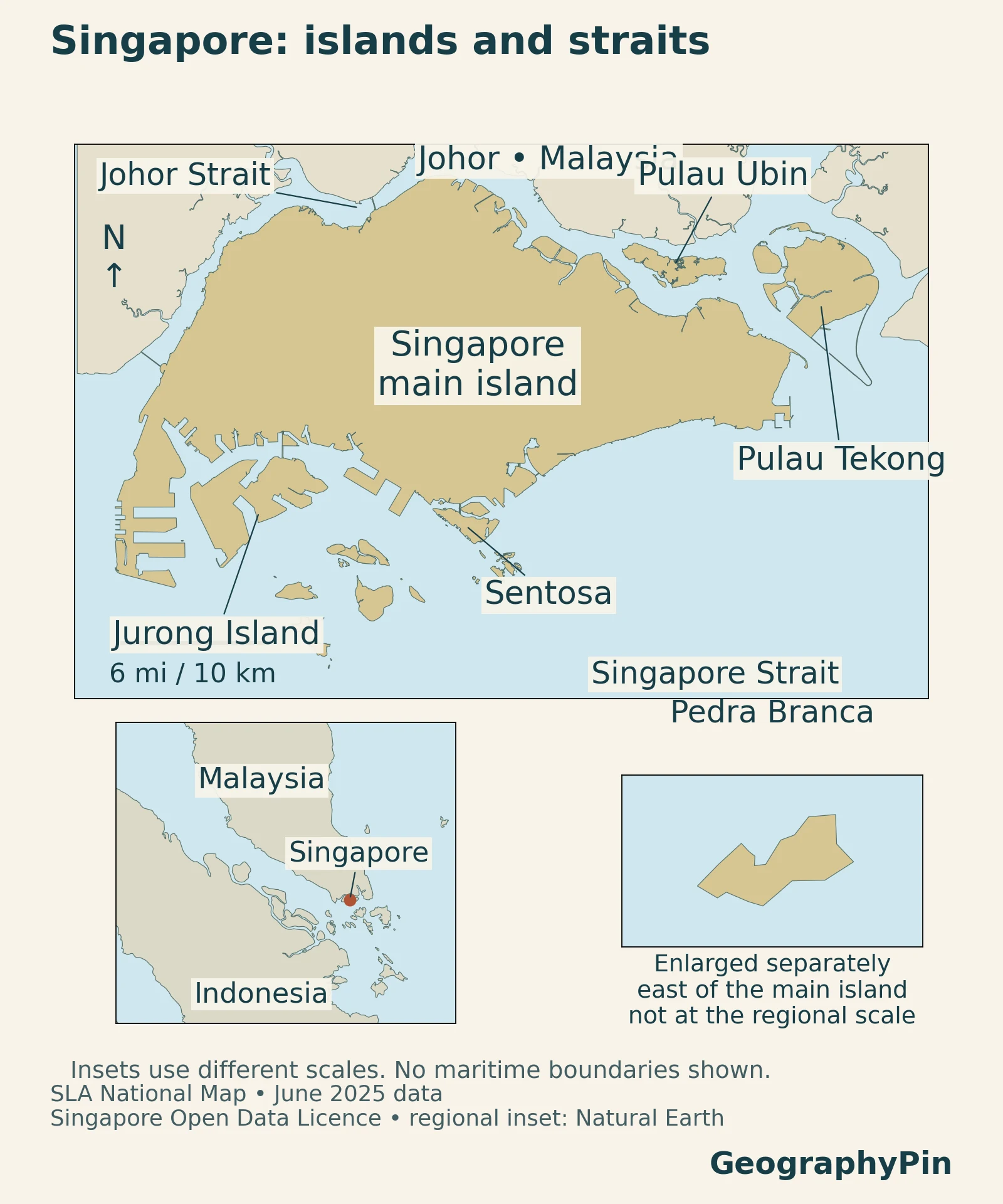
Singapore is a sovereign city-state in Southeast Asia, just off the southern tip of the Malay Peninsula. Malaysia lies to its north, across the Johor Strait, while Indonesian islands lie across waters to the south. The Singapore Strait is part of the country’s wider maritime setting, not another name for the Johor Strait.
A city-state is more than its downtown skyline
“City-state” describes Singapore’s national and urban setting; it does not mean that its territory is only a central business district. The main island contains neighborhoods, industry, reservoirs and protected green spaces. Smaller islands add other coastal settings, including Pulau Ubin, Pulau Tekong and Sentosa.
The Ministry of Foreign Affairs overview places Singapore at the southern end of the peninsula. On a regional map, the nearby sea routes and neighboring islands are as important as the main island’s outline. On a local map, reservoirs and land uses become more visible than that strategic position.
2. Country facts and population definitions
| Topic | Fact | Scope |
|---|---|---|
| Country form | Sovereign city-state | Singapore is both a country and a city-state |
| Total population | 6.21 million | At the end of June 2026 |
| Resident population | 4.23 million | Citizens and permanent residents, June 2026 |
| Land area | About 287.7 sq mi (745.1 km²) | June 2026 statistical measurement |
| Official languages | English, Malay, Mandarin and Tamil | Four official languages |
| National language | Malay | A separate designation from official-language status |
| Independence | August 9, 1965 | Independent sovereign republic following separation from Malaysia |
The 2026 population report distinguishes the total population from the resident population. In official statistics, “residents” means citizens and permanent residents. The National Population and Talent Division explains that the non-resident group includes foreign workers, dependants and students. It should not be read as a count of tourists.
These categories answer different questions. A total-population figure describes a broader group than a citizens-only count, while a statistic about resident households does not describe every person living in the country. Keeping the denominator attached is especially important when comparing housing or demographic figures.
3. The main island’s physical landscape
Low hills, ridges and eastern sedimentary terrain
Singapore is low-lying overall, but not perfectly flat. SingStat’s geographic explanation distinguishes central hills associated with granite, undulating western country and an eastern coastal area of alluvium and sediments. Bukit Timah and the central hills therefore belong to a different physical setting from the eastern coastal lowlands.
The geological background adds detail. Research on Singapore’s geology identifies central granitoid rocks, sedimentary rocks in the west and Quaternary sediments in the east. Bedrock and younger sediments underlie a surface that has also been reshaped by construction and reclamation.
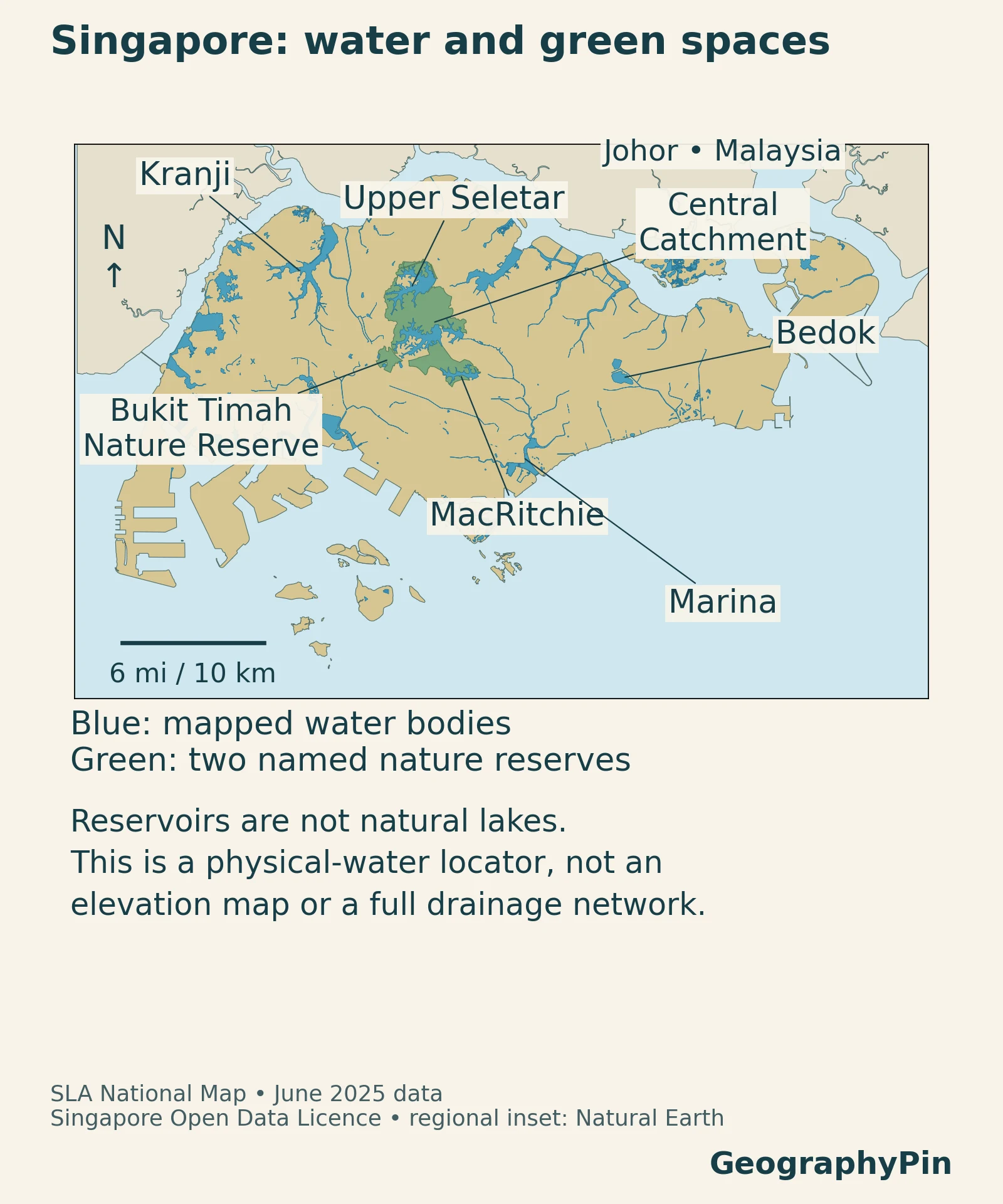
A road map can make Singapore look like one continuous built-up surface. A physical map draws attention instead to water bodies, hills and green areas within that development. The central forest-and-reservoir landscape is particularly useful for understanding why a dense city-state still contains contrasting local environments.
4. Reclamation, polders and dated land area
Why Singapore’s area needs a date
Land reclamation changes coastlines, so an area figure without a reference date can be misleading. SingStat’s published series gives about 287.4 square miles (744.3 km²) at December 2025 and 287.7 square miles (745.1 km²) at June 2026. The table above uses the later figure.
SingStat describes the cadastral high-water-mark basis of its land-area measurement. A national area statistic is therefore not obtained by tracing any convenient map on a screen. The June 2025 coastal geometry used in this article’s maps is also older than the June 2026 area statistic; the map is not presented as an exact 2026 land survey.
Reclaimed land does not always have the same elevation
Pulau Tekong provides a useful example of different reclamation methods. A September 2025 HDB and PUB factsheet describes Singapore’s first polder there: reclaimed land below mean sea level protected by a dike and supported by a water-management system. The project demonstrates that creating usable land and raising all that land above sea level are not the same operation.
The dike keeps surrounding seawater out, while drainage and water-level management remain essential inside the protected area. The low-lying ground therefore depends on the protective infrastructure around it.
Future development maps need another distinction. The Urban Redevelopment Authority’s Master Plan guides permissible land use and development over roughly ten to fifteen years. A planned use or future coastline on a planning map should not automatically be treated as a feature already built on the ground.
5. Reservoirs and urban water geography
Heavy rainfall does not remove the need for water planning
Singapore receives abundant tropical rain, but its small land area limits the space available to collect and store it. The Ministry of Sustainability and the Environment describes four supply sources: local catchment water, imported water, high-grade recycled water called NEWater, and desalinated seawater. These are the Four National Taps.
About two-thirds of the land surface serves as water catchment. Rainwater moves through drains and canals into reservoirs before treatment. Urban catchments make water quality part of land-use management: pollutants washed off developed land can enter waterways, so collecting rain is only one part of supplying usable water.
Marina separates a freshwater reservoir from the sea
At Marina, a barrier across the channel keeps seawater out. PUB explains that the barrage opened in 2008, with the reservoir subsequently becoming freshwater through replacement of its salty water by rainwater. It was commissioned as a freshwater reservoir in 2010. This is not a desalination plant converting incoming seawater into drinking water.
The barrage also manages excess stormwater. During heavy rain at low tide, gates can release water toward the sea. When the tide is high, pumps can discharge excess water instead. The same infrastructure therefore connects water supply, flood management and recreation, with operations depending on conditions on both sides of the barrier.
6. Green spaces and coastal habitats
Forest and reservoirs form a central landscape
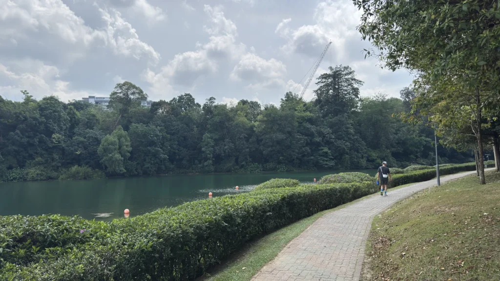
The Central Catchment Nature Reserve contains forest around reservoirs, with MacRitchie at its southeastern end. The featured photograph shows that wooded-water setting rather than the downtown skyline. The reserve also includes the Nee Soon freshwater swamp forest, illustrating that not every green area has the same water conditions or habitat.
Connections between green spaces matter as well as their size. NParks describes the Eco-Link across the Bukit Timah Expressway as a connection between Bukit Timah Nature Reserve and Central Catchment Nature Reserve. A patch of vegetation on a map is part of a larger ecological setting, not simply empty space awaiting development.
Pulau Ubin and Sungei Buloh show different shores
On Pulau Ubin, Chek Jawa brings together sandy and rocky shores, seagrass, coral rubble, mangroves and coastal forest. The island also contains former quarries that now provide habitats and landscape viewpoints. These settings show how natural processes and earlier land uses can coexist within a small island.
Sungei Buloh offers a mainland coastal example. The wetland reserve includes mangroves, mudflats, ponds and forest and is recognized for its importance to migratory birds. It is a different environment from a freshwater reservoir surrounded by inland forest. Both belong in a description of Singapore, alongside reclaimed industrial land and urban neighborhoods.
7. Climate and monsoons
A tropical climate with seasonal rainfall differences
The Meteorological Service Singapore describes high temperatures, humidity and abundant rainfall near the equator. The northeast monsoon generally runs from December to early March, while the southwest monsoon runs from June to September, with inter-monsoon periods between them.
These are not four temperate seasons, nor a simple division into a completely wet and a completely dry half-year. Rainfall is generally greater from November to January, while February is relatively drier. Afternoon thunderstorms, northeast monsoon surges and lines of thunderstorms known as Sumatra squalls can all contribute rain. Daily conditions can change substantially even though average temperatures vary little through the year.
8. Languages and national history
Four official languages and one national language
Article 153A of the Constitution names English, Malay, Mandarin and Tamil as official languages, while Malay is the national language. Official-language status and national-language status are distinct designations.
Singapore’s present national status dates from independence on August 9, 1965. It had joined the Federation of Malaysia in September 1963 before separating less than two years later. The shared peninsula-and-straits setting helps explain why the two countries’ histories are connected, even though they are separate sovereign states today.
9. Urban centres and the maritime economy
One city-state contains several employment centres
Singapore’s urban geography is not limited to a single downtown core. URA’s decentralisation strategy identifies regional centres including Woodlands, Jurong Lake District and Tampines. The strategy aims to bring employment and services closer to different residential areas and combine uses rather than concentrate every activity in the centre.
The 2026 population report also shows why neighborhoods matter: more than half of residents lived in nine of the fifty-five planning areas. These are resident-population statistics, not a map of every worker or visitor moving through the city during a day.
The port connects a small territory with a large trading network
The Ministry of Transport links Singapore’s maritime role to its position on major shipping routes and to the services available there. Container handling and transshipment are part of the picture, alongside ship management, finance, insurance, supplies and other maritime activities. Transshipment means cargo is transferred between ships for onward transport; it need not be consumed in Singapore.
That distinction is important for understanding the city-state’s economic geography. The volume of trade passing through a port does not measure the size of the domestic market alone. Infrastructure and business networks allow a compact territory to serve routes and customers far beyond its own shoreline.
What Did We Learn Today?
Singapore’s geography combines an island-and-straits location with intensive management of limited land and water. Its skyline is only one part of a landscape that includes forests, wetlands, reservoirs, smaller islands and reclaimed coasts. Dates and definitions matter: a coastal map, a land-area statistic, a future development plan and a resident-population count each describe something different.
Sources & Data Notes
Population and the headline land area refer to June 2026. Residents comprise citizens and permanent residents; the total population also includes non-residents. The maps use June 2025 coastal and hydrographic data and are not a measurement of the 2026 land total. The cited constitutional consolidation is used for the specific language provisions in Article 153A.
- Ministry of Foreign Affairs: Singapore’s regional setting
- SingStat: Population Trends 2026
- National Population and Talent Division: June 2026 population definitions
- SingStat: land area at June 2026 and December 2025
- SingStat: physical geography and area measurement
- Lythgoe and colleagues, 2020: Singapore’s geological setting
- HDB and PUB: Pulau Tekong polder factsheet, September 2025
- URA: statutory land-use planning
- Ministry of Sustainability and the Environment: water supply and catchments
- PUB: Marina Barrage and its operation
- NParks: Central Catchment Nature Reserve
- NParks: Pulau Ubin’s habitats and former quarries
- NParks: Sungei Buloh Wetland Reserve
- Meteorological Service Singapore: climate and monsoons
- Constitution, Article 153A: official and national languages
- National Archives of Singapore: federation and independence
- URA: regional centres and decentralisation
- Ministry of Transport: Singapore’s maritime economy
Maps: GeographyPin. Contains information from SLA National Map Polygon, June 2025, accessed November 14, 2026 via data.gov.sg and made available under the Singapore Open Data Licence. Regional context uses Natural Earth public-domain data. No official endorsement is implied. Insets use different scales; mapped land is not a claim about territorial waters. The landscape map shows selected water features and two named reserve polygons, not measured elevation or a complete drainage network.
Featured photograph: MacRitchie Reservoir, August 8, 2025, LN9267 / Wikimedia Commons, CC BY-SA 4.0. Cropped and resized; the derivative retains the same license.
