Malaysia’s map has two distinct parts, and understanding both changes how the country’s geography makes sense. A mountain-backed peninsula faces Borneo across the South China Sea, while each region contains its own contrasts between cities, coastal lowlands and uplands. The country profile below connects those landscapes with dated national facts and the history of the federation.
Malaysia is a Southeast Asian federation divided into Peninsular Malaysia and East Malaysia by the South China Sea. Its geography includes coastal lowlands, mountain ranges, tropical forests and river systems. Kuala Lumpur is the national capital; Putrajaya is the federal administrative centre. Sabah and Sarawak occupy part, not all, of Borneo.
How to use this article: Start with the two national regions, compare Borneo’s terrain, or see why rainfall seasons differ.
1. Where is Malaysia?
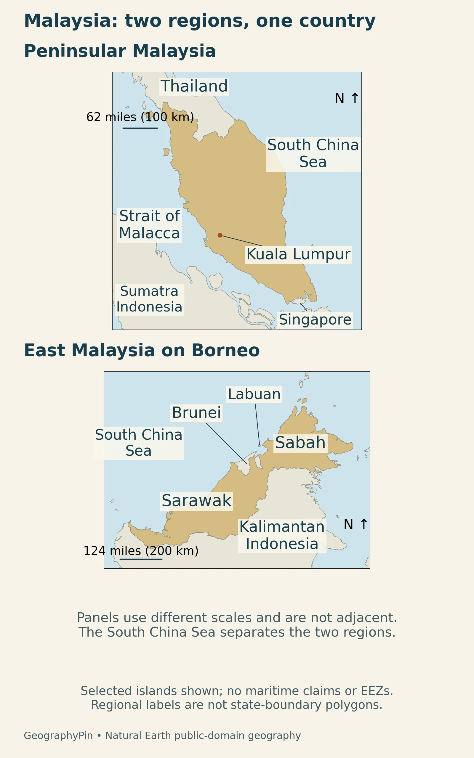
Malaysia is a Southeast Asian country with two main land regions separated by the South China Sea. Peninsular Malaysia occupies the southern part of the Malay Peninsula. East Malaysia lies on Borneo and includes Sabah, Sarawak and the nearby federal territory of Labuan. Borneo is not another name for Malaysia: Indonesia and Brunei also occupy parts of the island.
Two regions with different neighbors
Thailand borders the peninsula to the north, while Singapore lies beyond its southern end. On Borneo, Malaysia adjoins Indonesian Kalimantan and Brunei. The island’s political boundaries cut across a continuous landmass, whereas the sea separates Malaysia’s two main regions.
The PCGN geographic-names factfile distinguishes eleven peninsular states from the Borneo states of Sabah and Sarawak. This is a useful starting point for reading the map: “peninsular” and “East Malaysian” describe broad geographic settings, not two separate countries.
2. Country facts and administrative geography
| Topic | Fact | Scope |
|---|---|---|
| National capital | Kuala Lumpur | Distinct from the federal administrative centre |
| Federal administrative centre | Putrajaya | Location of the Prime Minister’s Office |
| Area | About 127,000 sq mi (330,000 km²) | Rounded from UN surface-area data for 2023 |
| Population | 34.4 million | DOSM estimate for the third quarter of 2026 |
| National language | Malay, or Bahasa Melayu | Not the only language used in the country |
| Currency | Malaysian ringgit (MYR) | National currency |
| Federal structure | 13 states and 3 federal territories | Territories: Kuala Lumpur, Putrajaya and Labuan |
The population is the Department of Statistics Malaysia’s quarterly estimate, not a census count or a whole-year average. The UN country table supplies the dated surface-area figure used for the rounded area above.
Kuala Lumpur and Putrajaya have different roles
Kuala Lumpur remains the national capital. Putrajaya is the federal administrative centre, rather than a replacement name for Kuala Lumpur. The Prime Minister’s Office describes its relocation to the Perdana Putra complex in Putrajaya in 1999. Both places are on the peninsula; Labuan, the third federal territory, is off Borneo.
The Federal Constitution identifies Malay as the national language and sets out the federation’s states and territories. A national-language designation does not mean that every community uses only that language. It also should not be confused with citizenship or with an ethnic label.
3. Peninsular mountains and coastal lowlands
The peninsula has an upland spine and two coastal sides
The Titiwangsa Range runs broadly north–south through the peninsula. The Malaysia Biodiversity Information System traces it from the Thai border toward Negeri Sembilan. Lower coastal country lies on either side: the Strait of Malacca is to the west, while the South China Sea lies to the east. Southern waters include the Strait of Johor.
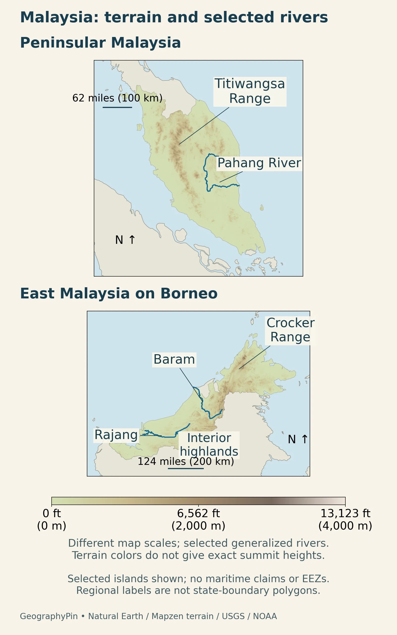
This arrangement helps explain why “coastal Malaysia” is not one uniform setting. A west-facing coastal plain, an interior mountain valley and an east-facing river mouth occupy different positions relative to the uplands and seasonal winds. The Pahang River shown on the map drains toward the peninsula’s eastern coast.
4. Borneo’s mountains, forests and karst
Sabah and Sarawak are not one flat coastal strip
Sarawak’s official geography overview describes coastal lowlands, hills and interior highlands. Sabah also contains major mountains. Their position on Borneo gives East Malaysia a different geographic context from the peninsula: rivers and uplands extend inland toward a much larger island interior, rather than across a narrow peninsula.
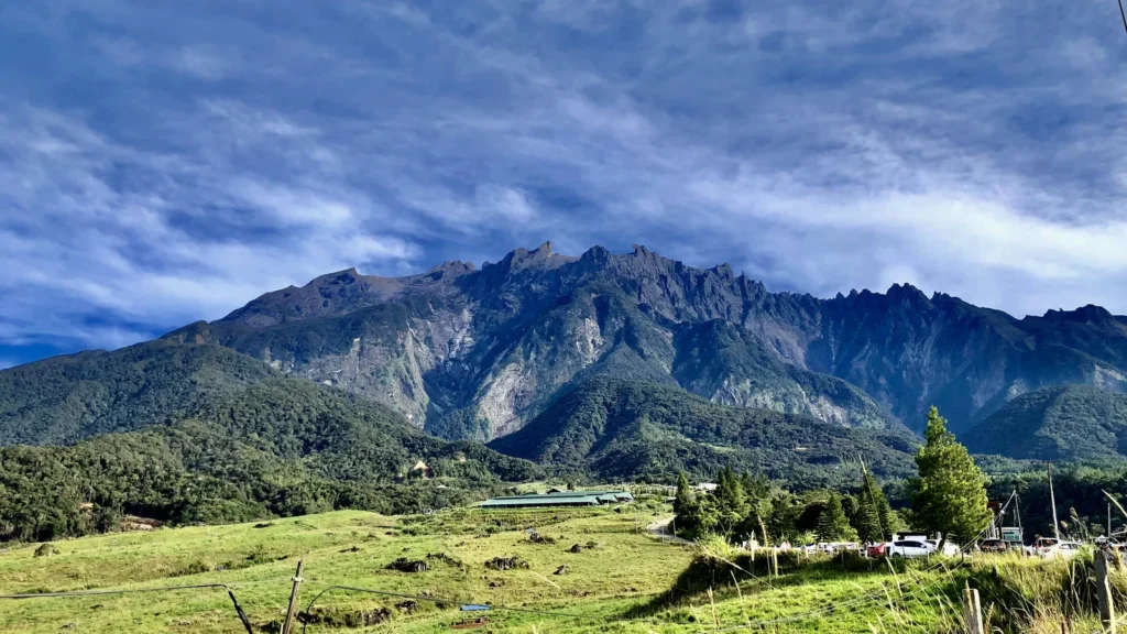
Mount Kinabalu in Sabah rises to about 13,435 feet (4,095 m), as listed by UNESCO. Its granite massif is a distinctive part of the landscape, but elevation alone does not explain the park’s ecological variety. Changes in altitude, steep terrain and different rocks create contrasting growing conditions.
High mountains and limestone landscapes support different habitats
Kinabalu Park includes lowland and hill rainforest, mountain forest, and higher scrub. A view of its exposed upper mountain therefore represents only part of the park, not the vegetation of all Sabah. The featured photograph shows the mountain above cultivated green foreground and wooded slopes, illustrating that local contrast.
In Sarawak, Gunung Mulu National Park offers another example. Its sandstone mountain stands within a landscape renowned for limestone karst, caves, deeply cut canyons and underground habitats. The distinction between sandstone and limestone matters: the entire mountain landscape is not one block of the same rock.
Caves and surface rivers connect parts of this karst environment. Water flowing underground helps create a drainage system that cannot be understood from visible river lines alone. The park is a particular protected landscape within Sarawak, not a model for every part of Malaysian Borneo.
5. Rivers link inland and coastal landscapes
The Rajang connects the interior with a coastal delta
The Rajang provides a clear river example in Sarawak. Research on the river and estuary describes an upper catchment in the interior mountains, a westward course through settlements including Kapit and Sibu, and branching channels toward the South China Sea. Its downstream landscape includes peat-covered lowlands.
The lower river is an estuary as well as a route for freshwater. Tides influence channels farther inland than saltwater necessarily reaches, so a tidal river is not automatically salty along its whole tidal reach. The freshwater–saltwater transition also shifts with conditions. These are features of a changing river–sea connection, not a fixed line that can be marked once for all seasons.
The map includes only selected river paths. Small tributaries and delta branches are not fully represented. In both national regions, following a river from upland to coast connects landforms that look separate when viewed only as place names.
Mangrove shores are more than a line between land and water
At the southern end of the peninsula, Tanjung Piai National Park protects intertidal mangroves and mudflats. The park authority describes erosion-control structures and mangrove planting in response to coastal pressures, including waves generated by nearby shipping. This is a managed coast as well as a habitat.
Within the site, vegetation changes with exposure and ground conditions. Trees growing in softer mud near the sea differ from those on firmer, more sheltered ground farther inland. These wetlands also provide resting areas for migrating waterbirds.
Farther north on the west coast, Matang in Perak provides a different example. A NASA and USGS satellite interpretation published in 2006 distinguishes its mangrove forest and tidal waterways from nearby farms and settlements, and describes harvesting and regrowth within the managed forest. That historical view illustrates how conservation, livelihoods and land use can overlap in a coastal landscape.
6. Monsoons and regional climate differences
Malaysia does not have one nationwide rainy season
The Malaysian Meteorological Department explains the regional effects of the monsoons. The northeast monsoon, generally November–March, brings particularly heavy rain to the peninsula’s east coast, western Sarawak and eastern Sabah. The southwest monsoon, from late May to September, is relatively drier across much of the country, but Sabah is an important exception.
The peninsula’s west coast commonly has rainfall peaks during the intervening monsoon-transition periods. Seasonal wind direction, coastal exposure and relief therefore need to be considered together. “Drier” is a comparison with wetter periods, not a promise of rain-free weather. A country-wide seasonal label cannot describe every coast and mountain location equally well.
7. How the modern federation took shape
The present map reflects a federation formed in 1963
The National Archives of Singapore’s constitutional-document account explains that Malaysia was formed on September 16, 1963, bringing together the Federation of Malaya, Singapore, Sarawak and North Borneo, now Sabah. Brunei did not join. Singapore became an independent sovereign republic on August 9, 1965.
That sequence helps explain two features of the modern map: Malaysia includes territories on both the peninsula and Borneo, while neighboring Singapore and Brunei are separate countries. Physical proximity alone does not determine political membership. The federation’s historical composition matters alongside coastlines and mountain ranges.
8. Cities and regional development
Economic geography varies within each national region
The World Bank’s July 2026 analysis describes substantial differences between Malaysian states and districts. It identifies Kuala Lumpur’s dominant position in the urban system, uneven development of medium-sized cities, and economic expansion around urban edges. Sprawling development can increase infrastructure costs and weaken the benefits of urban concentration.
These findings caution against reducing the country to a simple prosperous-peninsula versus undeveloped-Borneo contrast. Conditions vary within states, and infrastructure, institutions and access to jobs matter alongside natural resources and terrain. A national total cannot reveal all those local differences.
Administrative and statistical boundaries also deserve attention. OpenDOSM’s state GDP dataset includes Putrajaya’s economic value under Kuala Lumpur because attribution is difficult to separate. Its figures are measured at constant 2015 prices. Neither the combined reporting area nor that price basis should be mistaken for a separate city population or a current-price household income measure.
What Did We Learn Today?
Malaysia’s two-region shape is central to understanding the country. Peninsular and Borneo landscapes belong to one federation, but they have different neighbors, terrain and coastal settings. Mountains, rivers and seasonal winds create further contrasts within those regions. National statistics provide a useful overview, while local landforms, administrative boundaries and reporting dates explain why individual places cannot all be described in the same way.
Sources & Data Notes
Population is DOSM’s third-quarter 2026 estimate. Rounded area uses the UN table’s 2023 surface-area entry, not a new land survey. The 2010 constitutional reprint supports the specific language and federal-structure facts; the November 2026 PCGN factfile corroborates the geographic structure. Historical river research supports physical processes, not current flood or salinity predictions.
- Malaysia Biodiversity Information System: physical geography
- DOSM: population estimate, third quarter 2026
- United Nations Statistics Division: Malaysia country data
- Federal Constitution: Articles 1 and 152, 2010 reprint
- UK PCGN: Malaysia geographic-names factfile, November 2026
- Prime Minister’s Office: Putrajaya and Perdana Putra
- Sarawak government: regional geography
- UNESCO: Kinabalu Park
- UNESCO: Gunung Mulu National Park
- Müller-Dum and colleagues, 2019: Rajang River and estuary
- MET Malaysia: monsoons and weather phenomena
- National Archives of Singapore: federation and separation documents
- World Bank, July 2026: regional development in Malaysia
- OpenDOSM: state GDP, methodology and geographic coverage
- Johor National Parks: Tanjung Piai coastal wetlands
- Johor National Parks: Tanjung Piai habitats
- NASA and USGS: historical satellite interpretation of Matang
Maps: GeographyPin, with Natural Earth public-domain geography and rivers. Relief uses real Mapzen terrain, drawing on USGS SRTM/GMTED2010 and NOAA ETOPO1. The two panels have different scales; selected islands and rivers are shown, without maritime-claim lines. The generalized river feature labeled “Bajang” in the source data is displayed as Rajang after comparison with the cited river study’s geographic map.
Featured photograph: Mount Kinabalu, April 11, 2024, AustinXia / Wikimedia Commons, CC BY-SA 4.0. Cropped and resized; the derivative retains the same license. No GeographyPin watermark has been added to the photograph.

