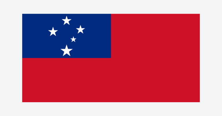
A map of Samoa needs two scales of explanation. At the regional scale, the independent country must be distinguished from neighboring American Samoa. Within the country, Savai‘i and Upolu dominate the landscape: volcanic interiors rise above coastal settlements, and the age and permeability of their rocks help determine where water flows above or below ground.
Samoa is an independent island country in Polynesia, centered on Savai‘i and Upolu in the South Pacific. Apia, its capital, is on Upolu. American Samoa is a separate US territory farther east, not part of the country. Samoa’s volcanic relief, contrasting rainfall and coastal connections help explain its landscapes, settlements and water resources.
How to use this article: Compare physical regions, understand water and rock, follow Apia and Faleolo, or check population coverage.
1. Locate Samoa and Define the Country
Samoa is not American Samoa
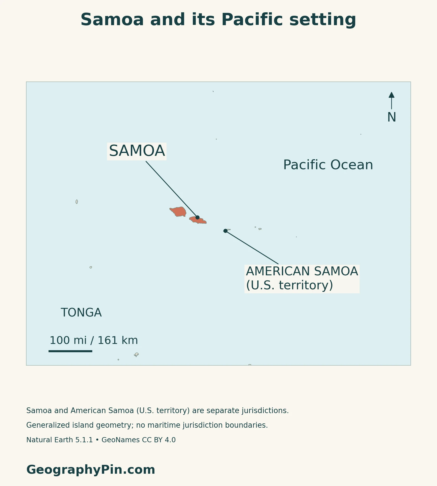
The Independent State of Samoa lies in Polynesia in the South Pacific. Its principal islands are Savai‘i and Upolu, with smaller islands including Manono and Apolima. American Samoa lies farther east and is a United States territory. The shared regional name does not make the two a single political unit.
Use the Oceania countries and capitals guide for the wider regional comparison. This profile’s population, area and government facts refer only to independent Samoa.
Nearby islands can have different calendar dates
Samoa uses UTC+13, while American Samoa uses UTC−11. Under the current time rules, their clocks show the same time but Samoa is one calendar day ahead. Samoa does not currently make a seasonal daylight-saving change.
For the calendar arithmetic and why the boundary differs from a meridian, see the International Date Line guide.
2. Savai‘i, Upolu and Their Volcanic Landscapes
Two large islands with distinct shapes
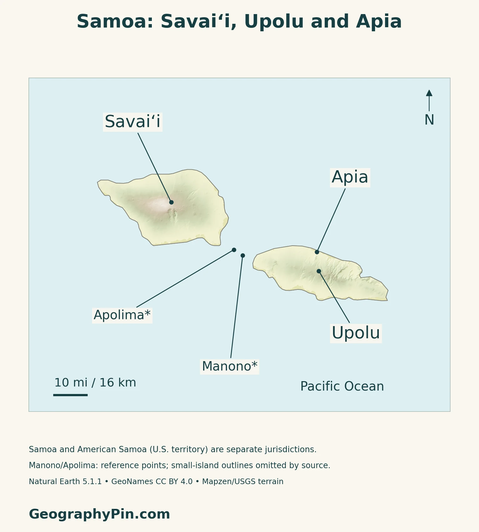
Savai‘i is Samoa’s largest island, west of the more elongated Upolu. Both have volcanic interiors rather than the low, narrow land surface of a coral atoll. The original terrain map makes their central high ground visible without treating every island as one identical cone.
| Place | Physical setting | Human-geography reference |
|---|---|---|
| Savai‘i | Broad volcanic island with a high interior | Salelologa is the eastern ferry gateway |
| Upolu | Elongated island with a central volcanic ridge | Apia lies on the northern coast |
| Manono and Apolima | Smaller islands between the two main islands | Part of Samoa, not American Samoa |
| American Samoa | Separate islands farther east in the same wider archipelago | US territory, excluded from Samoa’s country facts |
Lava has reshaped Savai‘i’s coast
The Smithsonian’s Global Volcanism Program describes Savai‘i as a broad basaltic shield with numerous smaller cones. Its historical eruptions sent lava toward the northern coast, where flows covered reefs and damaged villages. The Matavanu eruption lasted from 1905 to 1911.
Upolu also has a basaltic shield foundation, with cones and craters along its central ridge and younger flows on parts of its surface. Its last eruption is not precisely dated in the Smithsonian catalogue.
3. Rainfall, Groundwater and Crater Lakes
Season and exposure change the water supply
Samoa is warm and humid throughout the year, with a wetter season from November to April and a drier season from May to October.
Easterly and southeasterly trade winds interact with the high ground. The Pacific Soils Portal identifies wetter eastern Upolu and rain-shadow effects on western Upolu and parts of Savai‘i. Rainfall also varies between coastal and upland settings, so an observation at Apia cannot describe every slope.
Heavy rainfall does not guarantee a dense river network
The environment ministry’s 2023 assessment connects water resources to the underlying volcanic rocks. Older, more weathered rocks in eastern Upolu favor surface streams. Younger, more permeable rocks across much of Savai‘i and western Upolu allow more water to enter the ground.
This creates an important distinction between rainfall and accessible water. Some catchments carry water only seasonally or after storms; groundwater can also be difficult to reach or saline near the coast. A wet-looking island on a climate map therefore does not have the same water supply everywhere.
Lake Lanoto‘o shows another volcanic water landscape
In Upolu’s central highlands, the Lake Lanoto‘o Ramsar site includes three small crater lakes and associated wetlands. Samoa’s official site description links this forested upland landscape with the watershed serving Apia.
A lake, a stream and an aquifer store and move water differently. Their coexistence helps explain why protecting an inland catchment matters to people living on the coast, even where the uplands themselves are sparsely settled.
4. Apia, Gateways and Inter-Island Connections
Apia and Faleolo have different roles
Upolu held 78% of the population in the 2021 census, even though Savai‘i is the larger island. Apia is the capital on Upolu’s northern coast. Faleolo International Airport is farther west, on the island’s northwestern coast, about 25 miles (40 km) from Apia according to the airport authority.
The airport authority also identifies Maota near Salelologa and Asau on Savai‘i. These locations show how aviation infrastructure extends beyond the capital, without implying that every airport has the same services or a daily connection.
The main domestic ferry crosses between islands
Mulifanua on Upolu and Salelologa on Savai‘i are the principal terminals for the inter-island ferry. The Samoa Shipping Corporation distinguishes that domestic connection from its international route between Apia and Pago Pago in American Samoa.
The distinction is geographic as well as administrative: crossing from Upolu to Savai‘i stays within Samoa, whereas travel to American Samoa crosses into a separate territory.
Apia links the islands with overseas trade
The Samoa Ports Authority identifies Apia as the country’s international commercial port, while Mulifanua and Salelologa serve domestic movement. Asau, on Savai‘i’s northwestern coast, has a more restricted small-vessel role because of its approach channel.
Read alongside the terrain map, these gateways show how an island country is connected through particular coastal places. The capital, international airport and inter-island ferry terminal are not interchangeable points.
5. Country Facts with Dates and Coverage
| Item | Reference | Date or scope |
|---|---|---|
| Capital | Apia | On Upolu |
| Population | 205,557 | Final 2021 census; November 6, 2021 |
| Surface area | 1,097 sq mi (2,842 km²) | UN series, 2023; not territorial seas |
| Languages | Samoan and English | Constitutional legislative use explained below |
| Currency | Tala (WST) | 100 sene per tala |
| Government | Parliamentary democracy | Independent state, separate from American Samoa |
| District categories | 11 traditional districts; 51 electoral constituencies | Different from four census statistical regions |
The population is a dated census, not a 2026 estimate
The final 2021 census recorded 205,557 people on November 6. It counted people present who had been living in Samoa for at least three months, excluding short-term visitors and Samoans overseas for more than three months.
The Bureau of Statistics scheduled the 2026 enumeration for October 13–November 7. The figure above remains explicitly the final 2021 result; it does not substitute a fieldwork announcement for a published 2026 total.
Language and district labels need context
Article 54 of the Constitution provides for Samoan and English in Legislative Assembly debates and records.
Samoa’s 11 traditional districts, 51 electoral constituencies and four census regions describe different systems. The statistical regions are Apia Urban Area, North West Upolu, Rest of Upolu and Savai‘i. They are useful for population comparison, but they are not four provinces.
As with other island countries, the state and its largest island are not synonyms. Keep the national boundary separate from the geographic island group when comparing countries.
What Did We Learn Today?
Samoa and American Samoa belong to the same wider island region but are politically separate. Within Samoa, Savai‘i and Upolu combine volcanic high ground with coastal settlements and distinct gateways. Rainfall, rock permeability and catchment conditions work together to shape water availability. Apia’s capital and port roles, Faleolo’s airport and the Mulifanua–Salelologa ferry explain different parts of the country’s connections.
Sources & Data Notes
Population uses the final 2021 census with its stated residence coverage, not an assumed result from the 2026 census exercise. Samoa’s country facts exclude American Samoa. Climate descriptions are long-term patterns, not a current forecast. The water assessment is dated 2023; the Ramsar site description is dated 2012. Volcano records describe geological history, not a current eruption warning. Airport and port descriptions establish locations and roles, not current flight or sailing schedules.
- Smithsonian GVP: Savai‘i volcanic landforms and eruption history
- Smithsonian GVP: Upolu volcanic landforms
- Pacific Soils Portal: Samoa climate setting
- Samoa Tourism Authority: seasons and rainfall contrasts
- MNRE: State of the Environment 2023, water resources, pp. 54–55
- MNRE/Ramsar: Lake Lanoto‘o site information, August 2012
- Samoa Airport Authority: airport locations and roles
- Samoa Ports Authority: international and domestic ports
- Samoa Shipping Corporation: domestic and international network
- Samoa Tourism Authority: Mulifanua and Salelologa terminal locations
- Samoa Bureau of Statistics: final 2021 census, scope and regional tables
- Samoa Bureau of Statistics: 2026 enumeration announcement
- UN World Statistics Pocketbook 2025: Samoa, p. 212; surface area dated 2023
- Australian DFAT: Samoa’s sovereign status and government
- US Interior Department: American Samoa territorial status
- Samoa Constitution: Articles 44 and 54, constituencies and legislative languages
- Central Bank of Samoa Act 2015: section 40, tala and sene
- Samoa 2024 national assessment: section 1.4, traditional districts
- Samoa International Date Line Act 2011: standard UTC offset
- Maintained timezone database: Pacific/Apia and Pacific/Pago_Pago rules
Map method: Original GeographyPin maps use public-domain Natural Earth country geometry v5.1.1, real Mapzen/USGS elevation data and GeoNames reference points under CC BY 4.0. The country source retains Savai‘i and Upolu but omits smaller island outlines; Manono and Apolima are marked as reference points, not enlarged coastlines. American Samoa remains separately identified as a US territory. Two anomalous coastal elevation spikes and adjacent affected shading are omitted from the relief rendering, leaving neutral land color rather than substituted heights. No river courses, maritime limits, climate zones or date-line route are invented. The cover uses the two main-island outlines and an intact flag checked against Samoa’s official flag specification.