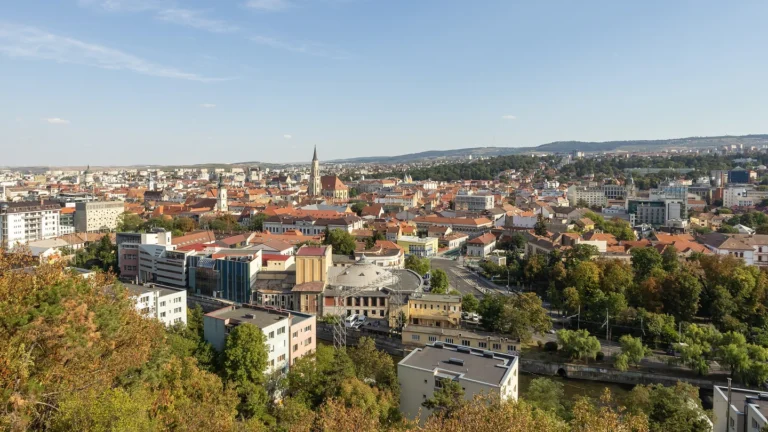
Romania’s mountains do not simply form one distant edge of the country. They curve through its interior, shaping the relationship between Transylvania, the surrounding lowlands and routes toward the Danube. The delta and Black Sea coast add another landscape entirely: low, watery and connected to a much larger international river system.
Romania is a European country with Bucharest as its capital and a coastline on the Black Sea. The Carpathians frame the Transylvanian interior, while hills and plains extend outward toward neighboring countries and the lower Danube. The river reaches the sea through a delta shared with Ukraine. Transylvania is a historical region, not a separate present-day country.
How to use this article: Start with the physical-region comparison, trace the river routes, or distinguish the delta from the canal.
1. Locate Romania between the Carpathians and Black Sea
Romania borders Hungary, Serbia, Bulgaria, Ukraine and the Republic of Moldova. Its southeastern coast faces the Black Sea. The national territory therefore connects inland Central and Eastern European landscapes with a maritime margin rather than occupying only one type of environment.
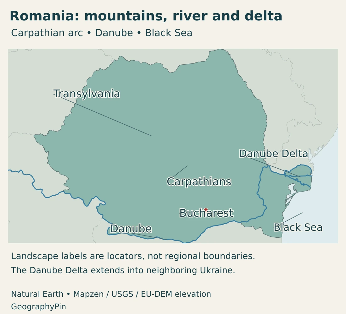
The Danube forms important stretches of Romania’s southern boundary before turning toward its delta. Bucharest is inland, south of the main Carpathian arc; it is not a port at the river’s mouth. Constanța lies on the coast, while the delta is farther north.
Physical regions and historical names are different layers
Names such as Transylvania, Wallachia, Moldavia and Dobrogea describe historical or geographic regions. They do not replace the country’s present administrative counties. The Romanian part of historical Moldavia should also be distinguished from the sovereign Republic of Moldova across the eastern border.
The Eastern European countries guide provides wider regional context. Regional labels can vary with the purpose of a map, but Romania’s national boundaries and its neighboring states are a separate question.
2. Country facts with dates and scope
| Fact | Value | Date or meaning |
|---|---|---|
| Capital | Bucharest | National capital; distinct from coastal Constanța and the delta. |
| Population | 19,041,322 | Provisional usual-resident estimate, January 1, 2026; not population by domicile. |
| Geographical size | About 92,046 square miles (238,398 km²) | EU country profile, 2026 geographical-size series; not a separately identified dry-land measure. |
| Official language | Romanian | Constitutional minority-identity rights also apply. |
| Currency | Romanian leu (RON) | Romania does not use the euro. |
| Administrative structure | 41 counties and Bucharest municipality | Historical and physical regions are separate classifications. |
| Government | Semi-presidential republic | President as head of state; prime minister leads the government. |
The resident-population estimate refers to people whose usual residence is in Romania, using a twelve-month residence or intended-stay criterion. It is not the same as the larger population-by-domicile series, which follows registered permanent addresses. People living abroad long term can therefore affect the two measures differently.
Population estimates are updated from the census using births, deaths and migration. A provisional figure should not be described as a newly counted census total. City populations require the same care: Bucharest municipality, its surrounding settlements and a wider metropolitan definition are not interchangeable.
3. Mountain arc, interior basin and outer plains
Read the country from the arc outward
| Setting | Position and terrain | Why the distinction matters |
|---|---|---|
| Carpathian arc | Mountain ranges curve through northern, eastern and southern parts of the interior. | Separates landscapes and influences routes, river catchments and local climates. |
| Transylvanian interior | A basin and plateau landscape inside the mountain framework, with the Apuseni Mountains to the west. | A basin need not be a flat depression at sea level. |
| Outer hills and plains | Hills and plateaus give way to broader lowlands, including the Romanian Plain to the south and western plains. | Provides different settlement and agricultural settings from the mountain crests. |
| Dobrogea and the delta | Land between the lower Danube and Black Sea, with the delta in the north. | Uplands, coast and delta wetlands should not be treated as one uniform surface. |
A mountain system with varied heights and forms
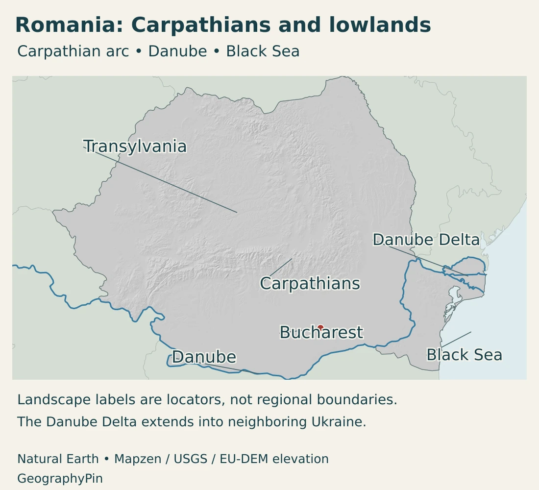
The Carpathians extend beyond Romania, so the Romanian arc is part of a wider European mountain system. Within the country, it helps organize the transition from higher terrain to foothills, plateaus and plains. Moldoveanu, the national high point, rises to about 8,346 feet (2,544 meters).
Mountain country is not a continuous wall. Valleys and lower crossings connect areas on different sides, while individual ranges contain different rocks and landforms. A national relief map is useful for seeing the broad pattern, but it does not show every pass, gorge or local road.
Why the Transylvanian basin is not a low coastal plain
The Transylvanian basin lies within the surrounding mountain framework. Geological research links its sedimentary history with the evolution and erosion of those mountains. The basin accumulated sediments during earlier stages of its development and was later affected by uplift and erosion.
“Basin” in this context describes a geological structure, not a promise that the modern surface is completely flat or below sea level. The present interior includes elevated, dissected terrain. The Apuseni Mountains distinguish its western side from the lower Pannonian setting farther west.
Historical Transylvania and the geological basin are also not identical concepts. A history map, a geological map and a county map can draw different boundaries because they answer different questions.
4. Climate, rivers and the Danube Delta
Romania has a temperate continental climate with regional influences rather than one uniform weather pattern. The national meteorological administration identifies Atlantic influences in the west, stronger continental conditions in the east, and distinct influences near the Black Sea and in the southwest.
Elevation adds another contrast. The Carpathian ranges have cooler, moist mountain environments, while lower terrain experiences different temperature and rainfall conditions. A coastal location does not make the whole country maritime, and a mountain climate should not be applied to Bucharest or the plains.
Different river paths lead toward the same sea
Most Romanian rivers belong to the Danube drainage system, but they do not all meet the main river in Romania. The Mureș and Someș flow toward the Tisza system, while other rivers reach the Danube more directly. Small coastal catchments provide exceptions to the broad Danube pattern.
This is why an interior river can flow away from the nearest stretch of Romania’s Black Sea coast and still eventually reach that sea. A drainage basin follows connected channels and terrain, not the shortest straight line across a national map. Our Danube River map follows the larger international system.
The delta is a wetland landscape, not the shipping canal
At the Black Sea, the Danube spreads through distributary channels and a mosaic of lakes, marshes, reedbeds and higher ground. The delta is shared by Romania and Ukraine. Its channels and shorelines are dynamic, so a generalized country map should not be read as a survey of today’s water edge.
The Romanian Danube Delta World Heritage property and the wider transboundary biosphere reserve are different designations with different boundaries. Neither label means that the entire delta is exclusively Romanian territory. Protected wetlands also contain human histories and livelihoods; they are not simply blank spaces between river channels.
The Danube–Black Sea Canal is a separate, engineered connection. Its main route reaches the Constanța port system, with a northern branch toward Midia. It should not be confused with the natural delta farther north or treated as another name for the river’s complete lower course.
5. Bucharest, regional cities and languages
Bucharest is the national capital and a center of government, education, business and culture. Its location south of the mountain arc differs from the interior setting of Cluj-Napoca or the Black Sea position of Constanța. Those contrasts help explain why the country’s cities perform different regional roles.
The capital is not a summary of every Romanian landscape. Mountain and foothill settlements, interior cities, agricultural lowlands and coastal communities have different relationships with transport and land. The national map becomes more useful when those settings are read together rather than as a list of place names.
Romanian language and minority identities
Romanian is the official language. The Constitution also recognizes the right of people belonging to national minorities to preserve, develop and express their ethnic, cultural, linguistic and religious identity. An official-language rule does not imply a population with only one identity or mother tongue.
Romania and Roma are not interchangeable terms. Romania is a sovereign state; Roma refers to an ethnic identity found in Romania and other countries. National population statistics count residents under their stated definitions, not just one ethnic group.
6. Government and geographic connections
Romania is a semi-presidential republic, with a president as head of state and a prime minister leading the government. Its territorial administration includes forty-one counties and Bucharest municipality. Historical regions and physical landscapes are not additional federal states.
The country uses the Romanian leu, not the euro. Membership of the European Union does not by itself mean that a country uses the common currency.
An inland manufacturing example
Mioveni illustrates an economic geography beyond the capital. Renault Group describes the Dacia site there as a complex combining vehicle assembly, chassis production and logistics. These activities link a Romanian industrial location with suppliers and markets outside the country.
The company’s Romanian locations also include engineering and design functions in Bucharest. Manufacturing and services can therefore occupy different sites within one production network. Their locations reflect investment, skills and transport connections as well as terrain.
The coast connects to inland waterways
Constanța provides a different kind of connection: a Black Sea port linked to the Danube by an artificial canal. That route allows the coast and the inland river network to function together without making Constanța a delta city.
The distinction matters when reading a transport map. A sea port, a river port, a canal and a delta are not equivalent features, even when vessels move between them. Romania’s position brings several of these systems close together.
Viewed as a whole, the country combines an interior mountain framework, inhabited basins and plains, international river connections and a maritime outlet. Its geography is not just a contrast between Transylvania and Bucharest: the delta, coast and outer lowlands are equally important parts of the national picture.
Frequently Asked Questions
Is Transylvania a separate country?
No. Transylvania is a historical region within modern Romania. The Transylvanian geological basin is a related but different geographic concept, not a present-day sovereign state.
Is the whole Danube Delta in Romania?
No. The delta is shared with Ukraine. Its Romanian World Heritage property and the wider transboundary biosphere reserve should not be treated as identical territories.
Is Bucharest on the Black Sea?
No. Bucharest is inland, south of the main Carpathian arc. Constanța is a major coastal city, and the Danube Delta lies farther north along the Black Sea margin.
What Did We Learn Today?
The Carpathian arc gives Romania a distinctive interior framework, but the country also includes broad lowlands, a Black Sea coast and a shared river delta. Transylvania’s historical identity differs from a geological basin or an administrative unit. River routes, the engineered canal and coastal ports connect these landscapes in different ways.
Sources & Data Notes
The population is a provisional usual-resident estimate for January 1, 2026, not a census count or a population-by-domicile total. The geographical-size figure follows the EU profile’s published series; no land–water split or population density is inferred. Unit conversions are rounded.
- Romanian national authorities, country report to FAO, 1995: Stable physical framework: Carpathian arc, hilly Transylvanian interior, southern and western plains, Dobrogea and the delta. Historical agricultural and population statistics are not current data.
- European Union, Romania country profile: 2026 population and geographical-size series, capital, institutions, counties and currency.
- Romanian National Institute of Statistics, usual-resident population methodology: January 1 reference date, twelve-month residence criterion, census-based updates and provisional status before the December revision.
- Constitution of Romania, official consolidated text: Articles 3, 6, 13 and 14: territorial administration, minority identity rights, Romanian language and Bucharest capital.
- Study in Romania, national geography: Neighboring countries, broad relief and Moldoveanu elevation. Current population and area follow the separately dated statistical sources above.
- Sanders and colleagues, Transylvanian basin research, 2002: Sedimentary basin history and the surrounding Carpathian and Apuseni mountain framework.
- FAO, Inland Fisheries of Europe: Romania: Reference for broad physical regions and drainage connections. Historical population, political boundaries and fisheries statistics are not used as current data.
- National Meteorological Administration, Romania’s climate: Regional climatic influences and elevation contrasts.
- UNESCO, Danube Delta World Heritage property: Romanian World Heritage designation and wetland setting.
- UNEP-WCMC, Danube Delta datasheet: Dynamic delta landforms and the distinction between the World Heritage property and wider transboundary landscape.
- Ramsar, Danube Delta conservation report: Historical report establishing the shared Romanian–Ukrainian wetland setting; its dated species and investment figures are not current counts.
- Administration of the Navigable Canals: Engineered Danube–Black Sea connection to Constanța and the northern branch toward Midia.
- Renault Group, Mioveni plant: Vehicle assembly, chassis and logistics activities at the Dacia industrial site.
- Dacia, Romanian locations: Bucharest engineering and design functions, distinct from the Mioveni manufacturing location.
- European Commission, Roma in Romania: Roma as an ethnic minority, distinct from the country name; no population estimate is taken from this page.
Map sources and scope: Original GeographyPin maps use public-domain Natural Earth country boundaries, populated-place coordinate attributes, rivers and lakes. The complete modern Romanian source outline is retained. Boundaries are generalized, not an official boundary survey.
Bucharest uses the source city coordinates. The Carpathians, Transylvania and Danube Delta labels mark broad geographic locations, not surveyed region boundaries. Transylvania locates the interior basin area rather than the full historical region. The delta extends into Ukraine; its marker is not a protected-area boundary or a depiction of its complete extent. The Danube and selected delta arms follow actual source lines, not invented routes. Water features are generalized and do not depict current levels or navigation channels.
Hillshade is calculated from genuine elevations accessed through Mapzen Terrain Tiles, with no vertical exaggeration. Global elevation data courtesy of the U.S. Geological Survey. Produced using Copernicus data and information funded by the European Union – EU-DEM layers. Elevation-source attribution and terms apply. Shading is not bathymetry or a set of numerical elevation bands.
The cover uses Romania’s national flag artwork from Commons. The intact flag retains its 3:2 proportions and appears separately from the decorative outline motif.