River capture, also called stream piracy, happens when water that formerly drained through one river system is diverted into another. It changes the drainage network, not just a river’s name. Erosion can create the new connection, but glacier retreat and other landscape changes can also reroute flow across a drainage divide.
How to use this article: Follow the before-and-after diagram, examine the Yukon evidence, or compare capture and avulsion.
1. River capture changes where water goes
A river network is more than the blue line carrying its name on a map. Smaller streams feed larger ones, and the surrounding land supplies water to that network. A drainage basin, or catchment, is the area draining toward a particular outlet. A drainage divide separates neighboring drainage areas. The USGS explains these terms in its watershed guide.
Capture changes that arrangement. Part of the water supply that used to follow one route begins following another. The receiving river gains the diverted flow; the former route loses it. The amount transferred depends on the event. Capture need not remove every tributary, spring or drop of water from the losing river.
Follow the outlet, not just the bend
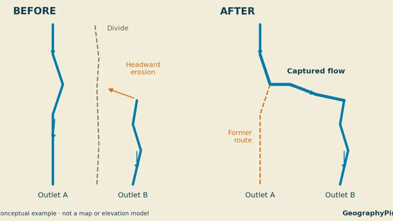
Imagine two neighboring streams draining toward outlets A and B. Before capture, the upper part of stream A feeds outlet A. After a new connection develops, that same upper flow reaches outlet B instead. The downstream destinations, rather than the river labels, reveal the change.
This also explains why a simple confluence is not enough to demonstrate capture. Two rivers joining today tells us how the network is connected now. To establish capture, we need evidence that some water previously took a different route.
The term piracy is a metaphor. Water is not choosing a better river or being pulled uphill. A changed landscape provides a route along which it can flow downhill. The scientific question is what changed that route and when.
2. How headward erosion can produce capture
One classic mechanism involves headward erosion, the upstream extension of a valley or channel. Downcutting and erosion around a stream’s head can allow its drainage network to reach farther into the landscape. If it intercepts a neighboring drainage and creates an effective downhill connection, water can be diverted into the expanding network.
The University of Alberta’s Planet Earth textbook describes this relationship between downcutting, headward erosion and capture. It is a mechanism, not a rule that every rapidly eroding stream must eventually capture its neighbor.
Read the before-and-after diagram
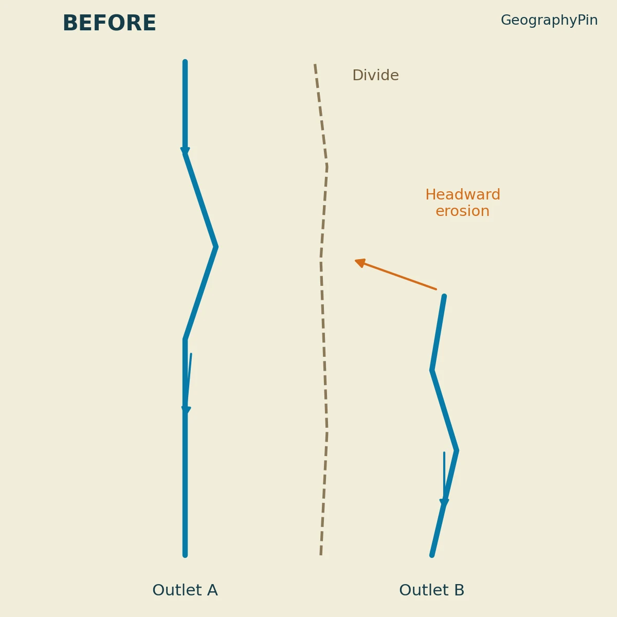
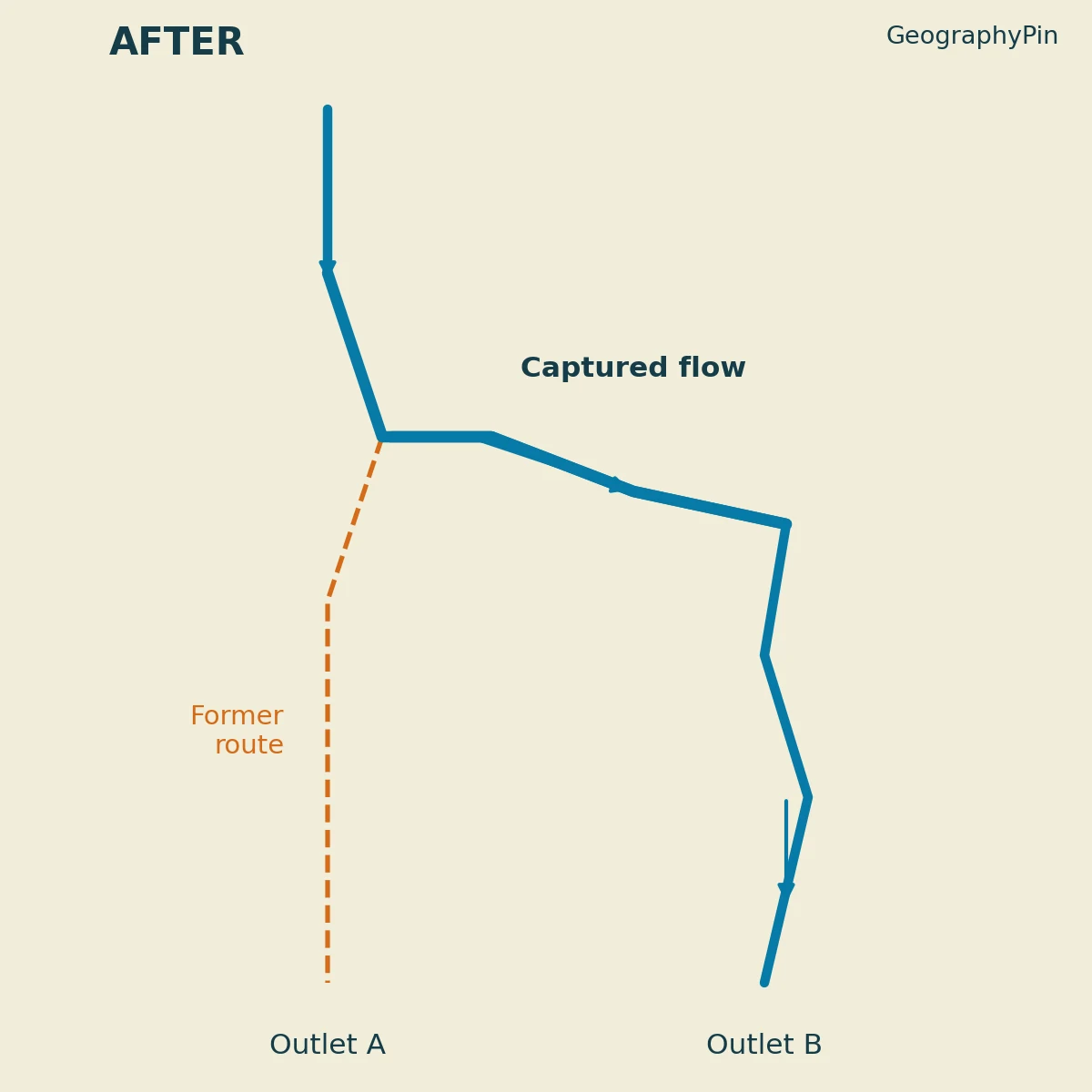
The orange arrow in the first panel shows the direction in which the channel head is extending. It is not a water-flow arrow. Blue arrows show water moving downstream. In the second panel, the new blue connection carries the upper flow toward outlet B. The dashed orange line marks the former route toward outlet A.
This is an original conceptual diagram, not a map of a real river. It illustrates the change in network connections; it does not calculate slopes, erosion rates, discharge or the exact position of a new watershed boundary. The former route is shown without an active blue channel for clarity, although real captured valleys may retain smaller streams supplied by local runoff or groundwater.
Why the smallest river is not automatically the loser
A river’s apparent size on a map does not determine which system will capture another. What matters is whether erosion and the surrounding topography create a new route for drainage. A small stream can extend into the drainage of a larger one. Conversely, many neighboring rivers remain separate despite differences in size.
“More powerful river steals a weaker river” is therefore a poor explanation on its own. It skips the physical connection that must develop and implies that channel width is a sufficient test. A useful explanation identifies the landscape change, the new downhill path and the water supply that is redirected.
3. The Yukon example: glacier retreat rerouted meltwater
The 2016 Kaskawulsh event in Canada’s Yukon provides a documented example that does not require the classic headward-erosion sequence above. Retreat of the glacier opened a different route for meltwater near its front. Daniel Shugar and colleagues investigated the change using hydrological measurements, satellite imagery and drone-derived elevation data. Their study was published in Nature Geoscience in 2017.
Two drainage routes, not two separate oceans
Before the change, much of the glacier’s meltwater traveled north along the Slims River into Kluane Lake and the Yukon River drainage, ultimately toward the Bering Sea. After the rerouting, most went through the Kaskawulsh River into the Alsek system, which reaches the North Pacific coast. The USGS account traces these connections.
The Bering Sea is itself part of the Pacific Ocean. Describing this as a transfer “from one ocean to another” would obscure the actual geography. The important change was between two drainage systems and their different coastal outlets.
| Route | Before the spring 2016 reorganization | Change documented in 2016 |
|---|---|---|
| Slims River → Kluane Lake → Yukon drainage | Received most of the glacier’s meltwater | Lost the glacier-fed supply that had sustained its large flow |
| Kaskawulsh River → Alsek drainage | Already received some meltwater | Became the route for most of that meltwater |
These are simplified drainage connections, not uninterrupted lists of every intervening river. They describe the reported event, not a new survey of present-day conditions.
What the satellite images show
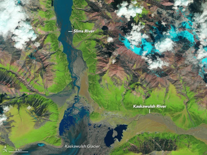
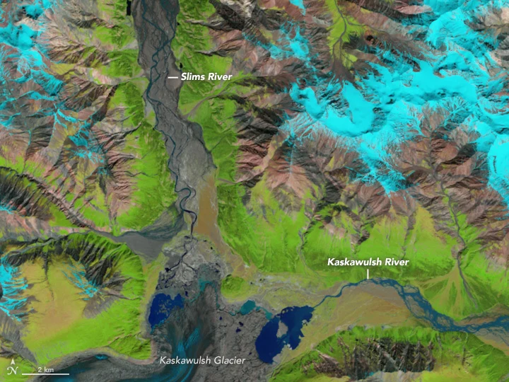
NASA’s Landsat images were acquired on June 23, 2015 and June 18, 2016. They are false-color views: dark blue identifies water, vegetation appears green, and snow and ice appear light blue. Comparing the same valley in the two images shows the greatly reduced Slims River and the changed distribution of meltwater near the glacier.
A satellite image is not a discharge meter. The evidence for capture comes from the images together with the researchers’ measurements and terrain analysis, not from treating the width of a colored patch as an exact volume of water. The NASA explanation provides the image dates, color interpretation and original credit.
The study linked the glacier retreat behind this event to industrial-era warming. That does not mean all river capture is caused by modern climate change. Nor should the paper’s predictions about possible later changes to Kluane Lake drainage be reported as events already observed in 2016. The established result is the rerouting of glacier-fed headwaters described in the 2017 research paper.
4. Capture is not the same as every channel change
Rivers change in several ways. Their banks erode, bends migrate and channels can be abandoned. Those changes matter, but they do not all demonstrate capture by another drainage system.
Capture versus avulsion
An avulsion is the abandonment of an established channel for another course. It commonly involves a new or reoccupied path across a floodplain. The term describes channel switching; capture emphasizes the transfer of drainage into another stream system. Natural Resources Canada’s flood-mapping guidance describes avulsion as movement into a newly created or previously active channel.
The concepts are not necessarily mutually exclusive. A channel-switching event can help establish a connection that transfers drainage. But an avulsion within one river’s floodplain does not, by itself, prove that a neighboring river has captured its headwaters.
| Observation | What it tells you | What it does not establish alone |
|---|---|---|
| A river occupies a different channel | Its course has changed | That flow was transferred between neighboring drainage systems |
| A small stream occupies a large valley | Present flow and valley size differ | The cause or date of that mismatch |
| A river has a sharp bend | Its course changes direction | That the bend is a capture site |
| Historical and terrain evidence show flow changing drainage routes | A former connection was replaced | The mechanism without further evidence |
Table downloads (2)
- Glacier-fed drainage routes before and after the 2016 Yukon event (3 × 3)View tableDownload CSV
- Evidence and limits when interpreting river capture (5 × 3)View tableDownload CSV
A dry valley is a clue, not a complete history
The Alberta textbook notes that capture can leave a large valley carrying little or no water. That is a useful starting point for investigation, not permission to label every dry valley a captured river. A cautious interpretation asks how the valley formed, where its former flow went and whether the proposed connection is consistent with the terrain.
5. How scientists test a capture explanation
The Yukon study illustrates why several types of evidence are stronger than a single striking map. Images from different dates establish change. Flow observations identify the redistribution of water. Elevation data help test whether the proposed route is physically plausible.
Ask three questions of any capture claim
- What was the former route? Look for dated evidence or a documented reconstruction, rather than assuming today’s river names describe the past.
- What new connection replaced it? Identify the receiving drainage and the physical path that redirected the water.
- What changed the landscape? Distinguish an observed trigger, such as glacier retreat, from a proposed explanation that still needs testing.
These questions are a reading guide, not a substitute for fieldwork. An attractive before-and-after sketch explains a hypothesis; it cannot establish the history of an actual valley. Likewise, a map of current drainage shows where water goes now, not automatically how the network evolved.
Capture can change more than river discharge. Water also carries sediment. A receiving reach may gain sediment while a lake or former channel loses a supply it previously received. USGS identifies these changes as potential influences on channel erosion and downstream habitats in the Kaskawulsh case. The consequences depend on the particular river system; they should not be turned into a universal prediction of flooding, drying or ecological damage.
Frequently Asked Questions
Does river capture mean an entire river disappears?
Not necessarily. A captured river can lose an important headwater supply while retaining water from other tributaries, springs or local runoff. “Disappearance” can be a dramatic shorthand, but the more precise question is which part of the water supply was diverted and what flow remained.
Does headward erosion mean water flows uphill?
No. The channel head or valley extends upstream as erosion changes the landscape. Water in the channel still flows downhill. This is why the diagram uses different arrows for upstream erosion and downstream water movement.
What Did We Learn Today?
River capture reorganizes a drainage network by redirecting water from one river system into another. Headward erosion is one mechanism, while the documented 2016 Yukon event involved glacier retreat and a new meltwater route. Capture is best established through evidence of former and replacement connections, not simply a sharp bend, a dry valley or a changed channel. The distinction matters because reorganized drainage also changes where sediment and water are delivered.
Sources & Data Notes
The original diagrams explain a hypothetical headward-erosion capture and are not reconstructions of the Yukon event. The Yukon case is based on the 2017 research and contemporary NASA/USGS accounts; predictions of later drainage changes are not treated as observations. Satellite scenes date to June 23, 2015 and June 18, 2016. Their original NASA/USGS credit is retained, and no GeographyPin watermark is added to them.
- USGS: Watersheds and Drainage Basins
- University of Alberta, Planet Earth: Rivers, Lakes, and Landscapes
- Shugar and colleagues (2017): River piracy and drainage basin reorganization led by climate-driven glacier retreat
- NASA Earth Observatory: River Piracy in the Yukon (2017)
- USGS EROS: Kaskawulsh Glacier, Canada (2017)
- Natural Resources Canada (2024): Geomorphic Considerations in Flood Mapping