Plovdiv spreads across both banks of the Maritsa River in southern Bulgaria. Most of the surrounding Upper Thracian Plain is low and open, which makes the compact group of hills in the old city easy to pick out. The river, hills and municipal boundary tell three different stories about where the city begins and ends.
Plovdiv is a city on the Maritsa River in Bulgaria’s Upper Thracian Plain. Bulgaria’s National Statistical Institute reported 333,994 residents in Plovdiv at the end of 2025, for both the city settlement and its municipality. The wider functional urban area is a different statistical unit, including surrounding municipalities linked to the city.
How to use this article: Start with the city and urban-area maps, find Old Town’s three hills, then compare municipal and wider-area population on the same date.
Plovdiv on the Upper Thracian Plain
How to read the city and wider-area maps
Plovdiv sits in the low, relatively flat corridor of the Maritsa. Farther south, the ground rises toward the Rhodope Mountains. This contrast matters at the wider scale: the same functional urban area covers lowland settlements as well as municipalities that extend into upland terrain. See the Bulgaria geography profile for the plain’s position in the country.
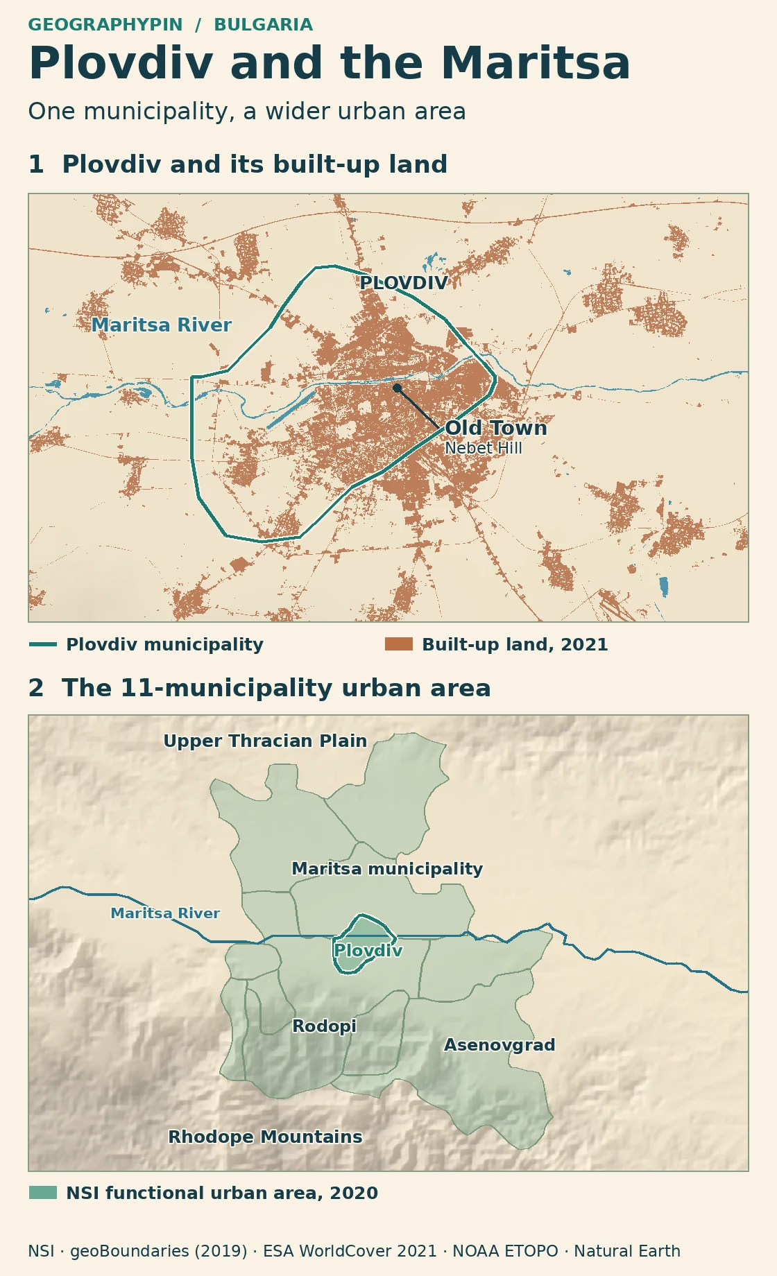
On the close-up, the green line outlines Plovdiv municipality. The orange patches show land classified as built-up in 2021, including clusters beyond that line. On the wider map, green shading identifies the 11 municipalities in the National Statistical Institute’s 2020 functional urban area. The shaded area is not a continuous city footprint; much of it is not built up.
Why Plovdiv is known for seven hills
Nebet Hill and the other Old Town hills
Plovdiv’s traditional count was seven. The municipal environmental program says Markovo Tepe was destroyed in the 1930s, which explains the count of six remaining hills. It also names the three closely spaced hills of the historic core: Nebet Tepe, Dzhambaz Tepe and Taksim Tepe. Together they are known as the Three Hills.
Look south of the Maritsa for this cluster, not at the center of the municipal outline. The old town occupies part of the hill group. Nebet Hill, or Nebet Tepe, is at its northern end and is the reference point marked on the close-up. The other three surviving hills belong to the broader city, not to the Old Town’s three-hill group.
The Maritsa is not the city boundary
The river runs through Plovdiv, with urban development on both sides. The municipality’s geography profile lists six city districts, including North and Central. The old town’s hilltops give one view of Plovdiv, but the wider city spreads across lower terrain rather than stopping at the river or the foot of the hills.
“Maritsa municipality” on the wider map names a different local authority north of Plovdiv. It is not another name for Plovdiv’s riverfront or North district. Rodopi is also a separate municipality, while the Rhodope Mountains are a physical feature extending well beyond it. Reading these labels as different kinds of place avoids confusing local government with the landscape.
Population: city, municipality and urban area
Compare population using the same date in each row
Bulgaria’s National Statistical Institute (NSI) published the same year-end population for the Plovdiv city settlement and for Plovdiv municipality in 2025: 333,994. These are distinct statistical labels even though their figures match. The larger functional urban area includes the city and surrounding communities linked to it, with commuting helping define the wider statistical area.
| Area | Population | Reference date |
|---|---|---|
| Plovdiv city settlement | 333,994 | December 31, 2025 |
| Plovdiv municipality | 333,994 | December 31, 2025 |
| Plovdiv municipality | 342,048 | December 31, 2020 |
| Plovdiv functional urban area, 11 municipalities | 542,203 | December 31, 2020 |
Compare the two 2020 figures to see what the wider boundary adds: 200,155 people lived across the other ten municipalities in that historical snapshot. Do not subtract the 2025 city total from the 2020 wider-area figure. That would mix years as well as geographic definitions. Plovdiv Province is a separate administrative area and is not a substitute for the wider urban measure.
Frequently Asked Questions
Which name helps locate Plovdiv’s historic center?
Look for Old Town or Nebet Tepe, also spelled Nebet Hill in English. It identifies the northern hill of the historic three-hill group, not a marker for all of Plovdiv.
Why do some sources say six hills and others seven?
Seven is the historic count. Six remain after Markovo Tepe was destroyed in the 1930s. Three of those six form the compact group associated with the Old Town.
Does a built-up area outside Plovdiv’s green line belong to the city?
Not necessarily. The mapped land cover identifies developed surfaces, not a legal boundary. A patch beyond the line could be a neighboring settlement or industrial land in another municipality.
What Did We Learn Today?
Look for the Maritsa and Nebet Hill to locate the city. Read the municipal outline for local government, and use the wider urban-area map to understand the region linked to Plovdiv. For population comparisons, use the same date as well as the correct boundary.
Sources & Data Notes
View sources and map notes
- Bulgarian National Statistical Institute: population by towns as of December 31, 2025 and final municipal population for 2025. These are dated estimates, not a 2025 census.
- NSI, Cities and Their Functional Urban Areas, 2010–2020, local table for area BG002L2 and municipality PDV22 at the end of 2020. The contemporaneous study and its 11 named municipalities define the comparison, not the province. Eurostat: functional urban area method.
- Municipality of Plovdiv geography; municipal air-quality program for 2025–2029, geographical setting and hills; Old Plovdiv Municipal Institute, three-hill group and Nebet Hill.
- GeographyPin used geoBoundaries Bulgaria ADM2 generalized 2019 municipal shapes, assembled against NSI’s 2020 roster, NOAA ETOPO 2022 relief and Natural Earth generalized river line. No district, city-settlement or province polygon is proposed.
- Built-up and water pixels are selected classes from ESA WorldCover 10 m 2021 v200, adapted under CC BY 4.0. © ESA WorldCover project 2021 / Contains modified Copernicus Sentinel data (2021) processed by ESA WorldCover consortium.
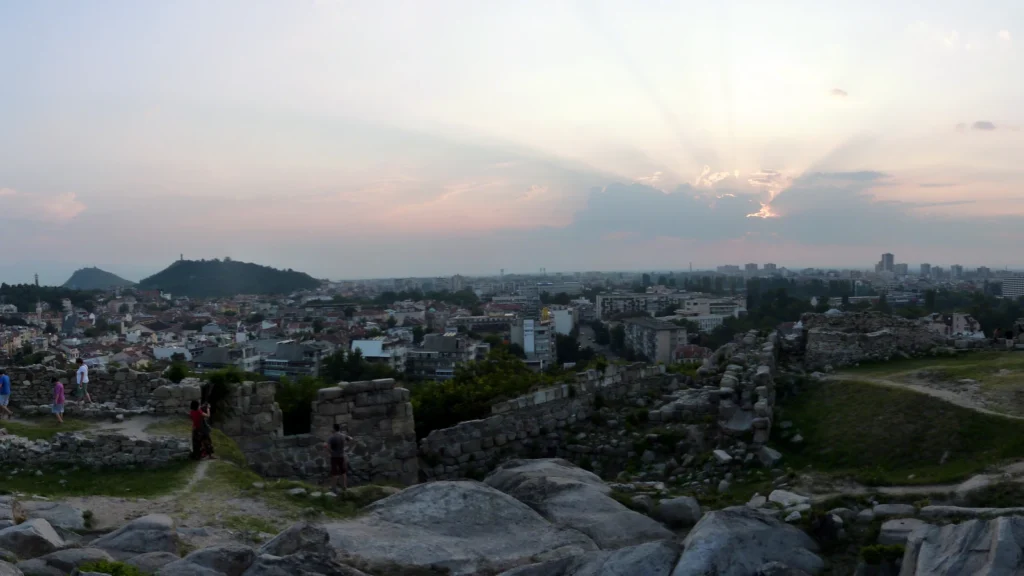
- Featured photograph: Erwan Martin, view from Nebet Hill, August 2014, CC BY 2.0, cropped.