Nusa Penida lies just off Bali, but arriving on the island of Bali does not put you on Penida. The map separates the main island of Nusa Penida from two smaller neighbors, the boat approaches and the one bridge people often mistake for a link to Penida.
Nusa Penida is southeast of Bali, across Badung Strait
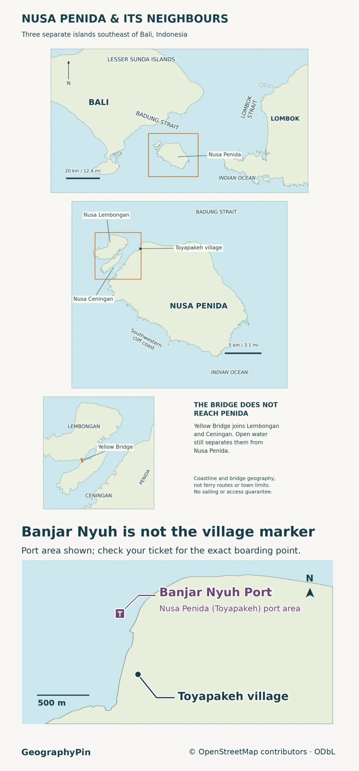
Nusa Penida is a separate Indonesian island southeast of Bali near the western end of the Lesser Sunda Islands. It belongs to Bali Province, but you cross Badung Strait by boat from the main island. The Yellow Bridge joins nearby Nusa Lembongan and Nusa Ceningan, not Nusa Penida.
How to use this article: Check which island your boat reaches, compare the cliff coast and port shore, identify both ends of the Yellow Bridge, or see what the name Nusa Penida can cover.
Nusa Penida on a map of Indonesia
Find Java on a regional map, then look east to Bali and Lombok. Nusa Penida sits off the southeastern shore of Bali, toward the western end of the Lesser Sunda island chain. The chain is a geographic grouping, not a province: Nusa Penida is in Bali Province, not West Nusa Tenggara.
On the local map, Nusa Penida is the largest of the three islands. Nusa Lembongan and Nusa Ceningan lie to its northwest, with Ceningan between Lembongan and Penida. The map shows the Indian Ocean to the south and the much broader opening of Lombok Strait to the east. The narrower Badung Strait is the Bali-facing crossing.
Badung Strait: The crossing from Bali
Check the departure and arrival island separately
Badung Strait, or Selat Badung, is the water between southeastern Bali and the Nusa islands. It is not the full Bali-to-Lombok crossing. Indonesia’s tourism authority names Sanur and Kusamba as departure areas on Bali, with Toyapakeh and Sampalan among the landings on Penida. These are names to check on a booking, not interchangeable docks or a list of every departure.
| Start and destination | Physical connection | What to verify |
|---|---|---|
| Main island of Bali → Nusa Penida | Boat across Badung Strait; no road bridge. | Confirm both named ports and the operator’s terminal. |
| Main island of Bali → Nusa Lembongan | Boat to a different island. | Check for a Lembongan landing if that is your destination. |
| Nusa Lembongan ↔ Nusa Ceningan | Yellow Bridge over the narrow channel. | Road and bridge map symbols do not establish current access. |
| Lembongan–Ceningan area → Nusa Penida | Separate water crossing to Penida, not a continuation over the bridge. | Confirm the island and pier the boat leaves from, then arrange onward transport. |
Bali’s transport department calls the Toyapakeh port Pelabuhan Nusa Penida (Toyapakeh) and places it at Banjar Nyuh in Ped village. For example, Ganesha Express lists Sanur Harbour on Bali to “Nusa Penida (Banjar Nyuh Port)” on its booking page. That is the two-port pairing to look for; check the date and boarding details on your ticket. Sampalan is a separate arrival on the north shore. Check the pier name before arranging a pickup; a ticket that says only “Nusa Penida” does not tell you where to meet a driver. For conditions at sea, use BMKG’s Badung Strait marine forecast and confirm your trip with the operator.
Nusa Penida’s limestone cliff coast
The high cliffs and the port shore are different landscapes
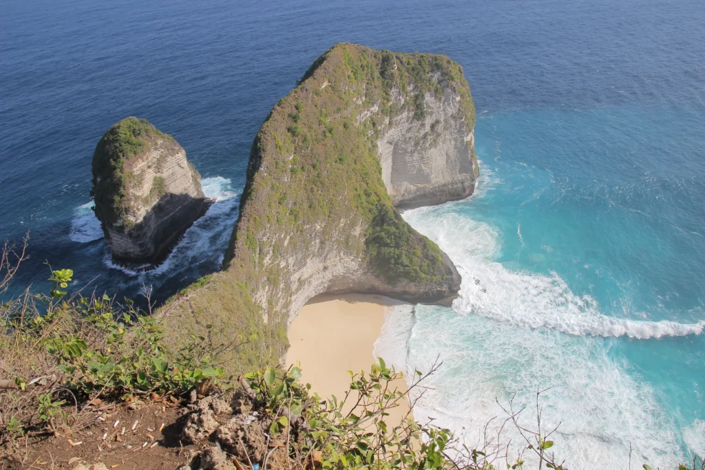
Fieldwork published by Indonesia’s Geological Agency distinguishes steep cliff coasts, sandy coasts and rocky shores. On Penida the pronounced cliffs are concentrated along the south, whereas the north has lower terrain and sandy coastal sections. That contrast explains why a boat landing and the cliffs in a photograph can be on very different sides of the same island.
The southern cliffs expose layered limestone. The coastal geology study describes wave-cut notches at some limestone faces and interprets part of the island’s broader north–south relief as uneven uplift. These are different processes: tectonic movement helps account for the elevated land, while waves and weathering work on the coastline. The evidence does not require every sea stack or cove to have the same history.
Kelingking is on the southwest coast, with Broken Beach on the same broad western side. Atuh and Diamond Beach are on the east. Treat the viewpoint and the beach below as separate access decisions. A coastline point on the map does not show a usable staircase, current ocean conditions, or a safe way down.
Lembongan and Ceningan: Where the bridge goes
The Yellow Bridge stops at Ceningan
Indonesia’s tourism authority describes the Yellow Bridge, or Jembatan Kuning, as the crossing from Nusa Lembongan to Nusa Ceningan. It crosses the narrow channel between those two islands. The water between Ceningan and the main island of Penida is separate. There is no through road to Penida by continuing across the Yellow Bridge.
This distinction also helps with place names. Jungutbatu is a settlement on Lembongan, and the district places its mangrove area there. If your visit is based around Kelingking on Penida, a boat ticket to Lembongan does not bring you to the same island. Check both the final landing and whether the island where you plan to sleep matches it.
The island, the district and the marine protected area
Three ways to read the name Nusa Penida
The island is one physical landmass. Nusa Penida District, or Kecamatan Nusa Penida, is the local administrative unit that includes the three inhabited islands: Penida, Lembongan and Ceningan. It is part of Klungkung Regency, which also has territory on the main island of Bali. The district name on an address does not by itself identify the island where that address sits.
There is a third use of the name. Indonesia’s fisheries ministry lists Nusa Penida Marine Conservation Area as a protected marine area in Bali Province. Its designated waters are not the land area of the main island or the land area of the district. A coastline or district map is not a substitute for the official conservation map when checking what activities are allowed in a particular location.
For an island itinerary, save two names rather than one: the island and the specific village, viewpoint or landing. The three islands belong together on a regional map, but the channels still affect where a person can go by land.
Frequently Asked Questions
Can a vehicle cross between Bali and Nusa Penida?
The Klungkung transport office announced that its roll-on, roll-off ferry between Padangbai and Nusa Penida resumed October 5, 2026 after maintenance. That is a separate service from the passenger fast boats. Confirm current sailing, vehicle eligibility and boarding point before relying on it.
Why might a map show few streams on the limestone hills?
Rainwater can seep into cracks and cavities in limestone instead of staying in surface channels. A Nusa Penida groundwater study found that cavities and porous limestone can hold water below ground. That does not mean the island has no water or that every mapped site has a reliable supply.
Is Broken Beach the same coastal feature as Kelingking?
No. Kelingking is a projecting limestone headland with a beach below it. Broken Beach, also called Pasih Uug, is a separate coastal cove with a natural rock arch. Their names appear together in excursion descriptions but refer to different stops.
Which islands does the Yellow Bridge connect?
It connects Nusa Lembongan and Nusa Ceningan. It does not connect either to Nusa Penida. The bridge close-up shows all three shores.
What Did We Learn Today?
Nusa Penida is in Bali Province, not on the main island of Bali. Badung Strait separates them, and the Yellow Bridge connects only Lembongan and Ceningan. Use the island name and a specific landing or site to tell a boat arrival, a cliff viewpoint and a district address apart.
Sources & Data Notes
Sources checked November 20, 2026. See Klungkung district geography, Klungkung regional map, Amerta field study and Lesser Sunda setting, Indonesia Travel island locations, Indonesia Travel Yellow Bridge and neighboring islands, Bali transport port locations, Klungkung October 2026 ferry resumption, Geological Agency coastal field survey, karst groundwater field study, Kelingking and Pasih Uug, Ministry marine conservation register. Port names identify places, not current departures. The map is a locator, not a navigation chart or a map of conservation zoning. Photograph from 2018: Kresnanta via Wikimedia Commons, CC BY-SA 4.0, resized and converted to WebP.

Map: GeographyPin; shorelines, locations and the Yellow Bridge from OpenStreetMap contributors (ODbL), with terrain from AWS Terrain Tiles. The map shows geographic context, not ferry tracks, operating status or administrative boundaries. The Banjar Nyuh port-area point is from Bali Governor Regulation 8/2021, Port Master Plan, §III.1, which locates Pelabuhan Nusa Penida (Toyapakeh) at Banjar Nyuh, Desa Ped (8°40′32″ S, 115°29′15″ E). The Toyapakeh village marker and shoreline geometry come from OpenStreetMap, ODbL. The port symbol marks the landing area, not a specific berth.