Malawi’s long lake is its most recognizable feature, but the country’s geography reaches well beyond the shore. Escarpments connect the lake basin with inland plateaus, while the Shire links northern waters to southern cities and the Zambezi. Reading those connections reveals why climate and livelihoods change so much across a relatively narrow country.
Malawi is a landlocked African republic with Lilongwe as its capital. Its geography combines Lake Malawi, steep Rift escarpments, central plateaus, Nyika’s northern uplands and the southern highlands. The Shire carries water from the lake toward the Zambezi, linking fishing and lakeshore communities with downstream water supply, irrigation and hydropower.
How to use this article: Compare the plateau and lakeshore, explore seasonal climate, or follow the Shire’s water connections.
1. Locate Malawi along the southern Rift
Malawi is a landlocked African country between Zambia, Tanzania and Mozambique. Zambia lies to the west, Tanzania to the north and northeast, and Mozambique along much of the eastern and southern side. Its elongated outline follows the southern part of the East African Rift system, with Lake Malawi occupying a prominent position along the eastern side.
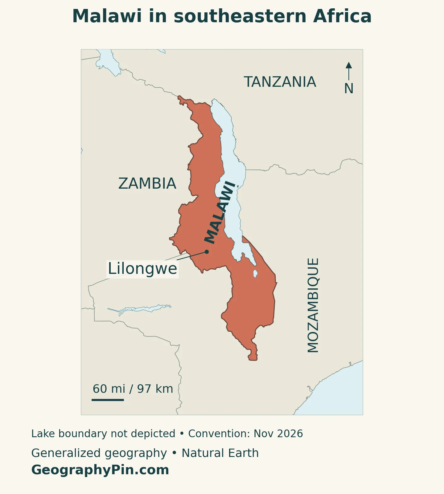
Lilongwe, the capital, is inland on the central plateau rather than on the lakeshore. The country’s long north–south orientation can obscure how much its terrain changes from west to east: uplands and escarpments descend toward the lake, while the Shire River carries water south into a different lowland setting.
Malawi belongs to the UN’s Eastern Africa statistical grouping and is also a member of the Southern African Development Community. These describe different kinds of regional association, not competing national borders. Our East Africa countries map explains the wider regional grouping.
2. Country facts with dates and coverage
| Fact | Reference |
|---|---|
| Official name | Republic of Malawi. |
| Capital | Lilongwe; capital since 1975, succeeding Zomba. |
| Census population | 17,563,749 people, final 2018 census. |
| Projected population | 21,201,635 people at midyear 2026, National Statistical Office projection based on the 2018 census. |
| Surface area | About 45,454 square miles (117,726 square kilometers), UNData reference year 2023; includes inland water. |
| Languages | English is the official language; Chichewa is the national language. Other languages, including Chitumbuka, are also spoken. |
| Currency | Malawi kwacha (MWK). |
| Administrative geography | Three regions and 28 districts; city authorities are distinguished from the surrounding districts in statistical tables. |
The 2026 population figure is a projection, not another census or a live count. The National Statistical Office moved its 2018 census base to July 1 before projecting later midyear populations. It should not be compared with a different organization’s estimate as if both were direct headcounts on the same date.
Surface area includes water as well as land. The 2018 census’s land-area table uses about 36,507 square miles (94,552 square kilometers) for its population-density calculations. That is a different measure from total surface area, not an alternative size for the entire country. Neither figure means that all of Lake Malawi belongs to Malawi.
3. Lake lowlands, escarpments and high plateaus
Malawi’s landscape is organized around a Rift valley, but it is not simply a country of lake shores. Plateaus extend inland, escarpments form steep transitions, and high mountains rise in the north and south. These changes in elevation help explain differences in temperature, water supply, cultivation and settlement.
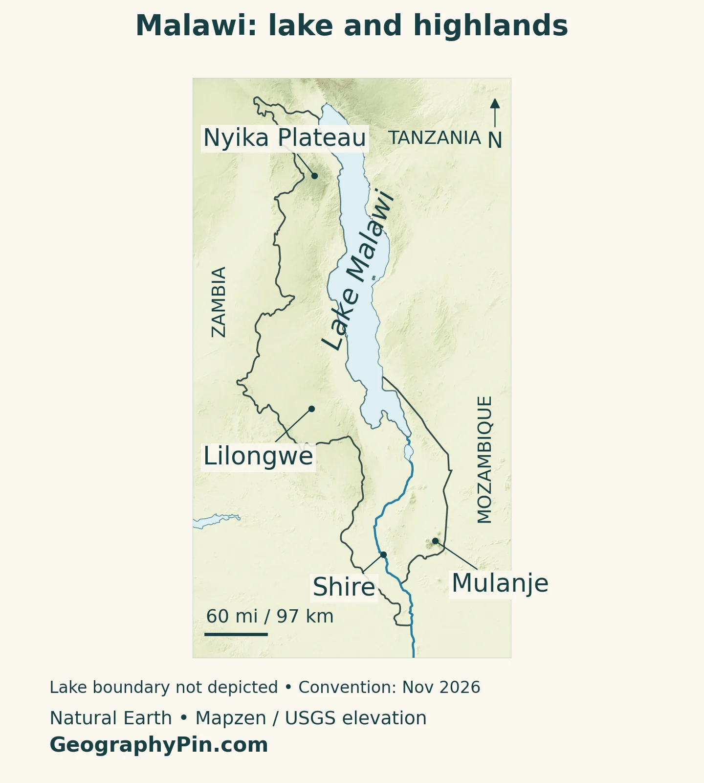
| Setting | What to recognize | Why it matters |
|---|---|---|
| Lake Malawi and its margins | A long Rift lake with adjoining plains and steep slopes | Fishing, shoreline settlements and water-level changes connect people with the lake. |
| Central and western plateaus | Rolling uplands, including the Kasungu–Lilongwe plain | Inland agriculture and the capital occupy a different setting from the lake lowlands. |
| Rift escarpments | Sharp transitions between uplands and lower terrain | Streams descend through these slopes, linking catchments with the lake. |
| Nyika Plateau | Northern high grasslands with forest patches | Cooler upland habitats contrast with lower lakeshore environments. |
| Southern highlands and Mulanje | High ground and a prominent massif above surrounding plains | Mountain environments and downstream water systems meet densely used landscapes. |
| Shire Valley | A southern river corridor leading toward Mozambique | River flow supports water supply, power generation and irrigation. |
The plateau and lakeshore are different living environments
The Kasungu–Lilongwe plain is an extensive agricultural plateau. Its gentler terrain contrasts with the more abrupt Rift escarpments, where streams cut down toward lower ground. In the Lake Malawi basin, weathered rock and sediment deposits also create different groundwater conditions: a borehole on a plateau does not tap the same kind of aquifer as one in lakeshore sediments.
Nyika adds another contrast. Malawi’s Department of Tourism describes a northern plateau of grasslands and montane evergreen forest. Farther south, Mulanje rises above plains and villages as a distinctive massif, not part of the same continuous high surface as Nyika. UNESCO inscribed Mount Mulanje Cultural Landscape in 2025, recognizing relationships between the mountain and surrounding communities as well as its physical presence.
4. How the lake shapes climate and settlement
Lake Malawi influences its surroundings, but elevation and exposure remain equally important. Research on the lake basin finds that relief and proximity to the water affect rainfall patterns. The lakeshore lowlands are generally warmer than the Nyika highlands; being beside the same lake does not give every nearby slope the same climate.
A summer rainy season, with strong local differences
Malawi’s main rainy season broadly runs from November through April. May through August is generally cooler and drier, followed by a hotter period in September and October before the next rains. These are seasonal patterns, not a guarantee that rainfall begins or ends on a particular day everywhere.
The meteorological service identifies strong southerly and southeasterly Mwera winds during the cooler season. Such winds can make lake conditions difficult for fishing and navigation even when inland weather seems relatively dry. Lake transport therefore depends on more than rainfall alone.
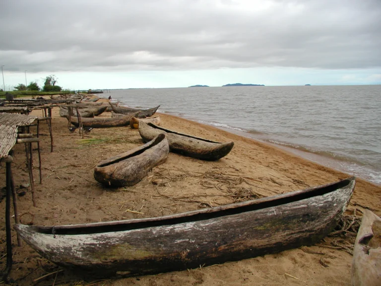
For settlement, the water creates opportunities and constraints at the same time. Fishing and lakeside activity depend on access to the shore, while changes in lake level can affect buildings and infrastructure close to it. Inland Lilongwe shows why Malawi’s population cannot be understood as a narrow ribbon around the lake: administrative activity and agricultural connections also sustain major centers away from the water.
Landlocked does not mean isolated from tropical-storm impacts. The meteorological service’s account of Cyclone Freddy in 2023 documents severe rainfall, flooding and landslides. Steep terrain, intense rain and downstream exposure can combine to produce hazards well beyond an ocean coastline.
5. Follow the Shire from the lake to the Zambezi
The Shire is Lake Malawi’s only outlet. It flows south through Malawi and continues into Mozambique, where it joins the Zambezi. This connects the lake with a much larger river basin rather than leaving it as an isolated inland water body.
One river connects electricity, drinking water and land management
The Kamuzu Barrage at Liwonde regulates outflow from the lake into the Shire. A World Bank explanation of the upgraded barrage emphasizes that it cannot independently control the level of such a large lake. Direct rainfall, river inflows from the surrounding basin, evaporation and outflow all affect the water balance.
Controlled releases can help sustain dry-season flows for downstream uses, including hydropower and irrigation. But a barrage is not a substitute for catchment management or flood planning. Heavy inflows can raise lake levels even when a structure downstream is operating.
Blantyre’s water supply illustrates the connection between lowlands and uplands. Blantyre Water Board draws water from the Shire at Walker’s Ferry, below the city, and pumps it uphill. A southern highland city therefore depends on a river fed by the lake far to its north.
The same river can carry sediment and aquatic vegetation into power infrastructure. The Millennium Challenge Corporation’s account of its Malawi environmental program describes how these materials obstructed equipment and reduced generating capacity. Soil conservation and vegetation management upstream can consequently matter to electricity users downstream, not just to the farms beside a stream.
These links explain why a physical map is useful for understanding the economy. Lake levels, river gradients, cultivated slopes and the position of cities form one connected system, even where they fall under different local authorities.
6. People, cities and a working landscape
Lilongwe became Malawi’s capital in 1975, replacing Zomba. Its central plateau location distinguishes it from lakeside settlements and from the southern urban centers. Lilongwe City Council describes its development from an agricultural market center into the national capital.
Blantyre is another major urban center in the south, while Zomba retains its identity as the former capital. National capital, largest city and principal commercial center are different roles; a country need not concentrate them all in the same place. For quick comparisons across the continent, see our African countries and capitals list.
Malawi is a republic. The Northern, Central and Southern regions provide broad administrative reference areas, subdivided into districts. They should not be mistaken for the physical regions in the map above: a district boundary does not necessarily follow an escarpment, drainage basin or habitat edge.
English serves as the official language, while Chichewa has national-language status and widespread everyday use. Other languages remain important, including Chitumbuka. These labels describe public roles, not a claim that every household speaks the same language.
Agriculture, urban services, water infrastructure and lake-related livelihoods occupy different parts of the landscape. The central agricultural plateau, the lakeshore and the Shire-connected southern cities each reveal a different relationship between people and terrain. None alone represents the whole country.
7. A shared lake, distinctive habitats and a disputed boundary
Lake Malawi is also called Lake Nyasa, particularly in Tanzania. The different names refer to the same lake, not to two neighboring bodies of water. Malawi, Tanzania and Mozambique all have shores on it.
A March 2026 legal study describes competing Malawi–Tanzania claims over the lake boundary. Malawi’s position places the boundary at the Tanzanian shoreline, while Tanzania advocates a line through the lake. In an August 2026 declaration deposited with the United Nations, Malawi expressly maintained its boundary position and stated that watercourse cooperation does not determine the lake boundary. A generalized country outline should not be read as a legal settlement of these competing positions. The maps here are geographic reference illustrations, not an adjudication of sovereignty.
Lake Malawi National Park protects a particular area at the lake’s southern end; the UNESCO listing does not cover the entire lake. Its importance includes the remarkable diversity of cichlid fishes and the evolutionary processes represented by them. Keeping the park distinct from the whole lake helps avoid overstating both its boundaries and what one protected designation covers.
Mountain, plateau and lake habitats also call for different kinds of care. Nyika’s grasslands and forest patches differ from Mulanje’s mountain landscape and the aquatic environments of the national park. Protecting one of these places does not automatically protect the river catchments and inhabited slopes that connect them.
What Did We Learn Today?
Malawi’s lake, escarpments, plateaus and southern highlands work as a connected landscape. Elevation and the lake influence climate, while the Shire carries water toward the Zambezi and supports users far from the lakeshore. Lilongwe occupies the central plateau, and neither a generalized lake boundary nor a national-park designation should be mistaken for the full geographic or legal story.
Sources & Data Notes
Population figures distinguish the final 2018 census from the NSO’s midyear 2026 projection. Surface area follows UNData’s 2023 reference; the separate land-only figure comes from the census density table. Climate descriptions are broad patterns, with cyclone impacts explicitly dated 2023. Lake naming and disputed jurisdiction are distinguished from physical geography. Sources checked November 16, 2026.
- United Nations depositary: Malawi’s August 26, 2026 declaration preserving its Lake Malawi boundary position
- Raege Omar (March 2026): legal study of the Malawi–Tanzania lake boundary dispute
- National Statistical Office: final 2018 census, population and land-area tables
- National Statistical Office: Population Projections 2018–2050, midyear method and Annex 1.5
- UNData: 2023-reference surface area and currency
- UK Permanent Committee on Geographical Names: 2025 languages and administrative geography
- SADC: Malawi’s regional membership, neighbors and republic
- Lilongwe City Council: capital history and central plateau setting
- Banda, Kalin and Phoenix (2024): Lake Malawi basin relief, climate and groundwater
- Department of Climate Change and Meteorological Services: State of Malawi Climate 2023
- World Bank water specialists (2024): lake levels, Shire outflow and the Kamuzu Barrage
- Blantyre Water Board: Shire abstraction and uphill water supply
- Millennium Challenge Corporation: Shire sediment, aquatic weeds and hydropower infrastructure
- Malawi Department of Tourism: Nyika plateau habitats
- UNESCO: Mount Mulanje Cultural Landscape, inscribed 2025
- UNESCO: Lake Malawi National Park and cichlid diversity
- Tanzanian High Commission: Lake Malawi/Nyasa naming and boundary dispute, December 2020
Map method: Original GeographyPin maps use public-domain Natural Earth country geometry, Lilongwe location, lake polygons and river channels. Lake water is shown uniformly, with no sovereignty boundary inside Lake Malawi. The cover excludes lake water from its land silhouette and does not depict lake jurisdiction. Relief uses Mapzen Terrain Tiles with USGS SRTM/GMTED2010 data; one isolated invalid inland elevation cell was replaced with the median of neighboring valid cells. Colors indicate elevation, not vegetation. Mulanje uses a UNESCO landscape reference, not a summit. Nyika uses the Nyika coordinate in Malawi’s tentative-list submission, not a protected-area boundary or evidence of inscription. Borders and shorelines are generalized; Web Mercator scale varies with latitude. The cover is an original flag-and-outline design.