Jordan River & the Dead Sea: How the River Feeds a Salt Lake
It’s the story of an endorheic system: the Jordan River delivers fresh water to the Dead Sea, which has no outlet and loses nearly all its water to evaporation—concentrating salts to ~10× ocean levels. Historically ~1.3 billion m³/year flowed to the lake; today, a small fraction arrives, driving dramatic level declines.
The River–Lake System at a Glance
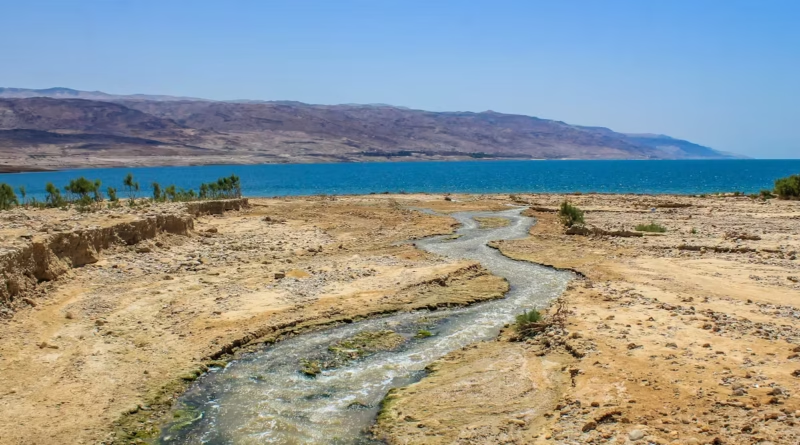
The Jordan River is fed by three cool headwater streams—the Hasbani/Snir, Dan, and Banias (Hermon)—which meet in the Hula Valley and form the Upper Jordan. The river enters the Sea of Galilee, exits at its southern tip, and then runs as the Lower Jordan to the Dead Sea. Total river length is about 251 km (156 mi). Key tributaries include the Yarmouk from the east and the Zarqa.
The Dead Sea sits roughly 430–440 meters (1,410–1,444 feet) below mean sea level, with its main northern basin about 50 km (31 mi) long and up to ~15 km (9 mi) wide. It’s “dead” because extreme salinity prevents typical aquatic life. As of 2025, widely cited figures place the shoreline around −438 to −440 m (−1,437 to −1,444 ft), reflecting a multi-decadal decline.
Headwaters and Tributaries
The Hasbani/Snir rises in Lebanon, the Banias from springs at Hermon’s base, and the Dan from one of Israel’s largest springs. After the Sea of Galilee, the Lower Jordan is joined by wadis and the Yarmouk (once the largest tributary), before entering the Dead Sea near the Lisan Peninsula.
| Metric | Value (first mention in both units) |
|---|---|
| Jordan River length | ~251 km (156 mi) |
| Dead Sea surface elevation (2025 range) | ~−438 to −440 m (−1,437 to −1,444 ft) |
| Historic inflow to Dead Sea | ~1.2–1.3 billion m³/yr (0.29–0.31 cu mi/yr) |
| Recent inflow to Dead Sea | ~<30–100 million m³/yr (0.007–0.024 cu mi/yr) |
| Dead Sea salinity | ~342 g/kg (~34%) vs. ocean ~35 g/kg (~3.5%) |
| Typical evaporation rate | ~1.1–2.0 m/yr (3.6–6.6 ft/yr) |
How the Jordan River Feeds a Salt Lake
In an endorheic (closed) basin like the Dead Sea, water comes in but does not flow out to the ocean. The Jordan River, plus smaller wadis and a network of saline springs, supply inflow. Because the climate of the Jordan Rift is hot and arid, nearly all water loss is through evaporation at the lake surface. Over centuries, this steady “input minus output” piles up dissolved minerals—chiefly chlorides of magnesium, sodium, calcium, and potassium—making the Dead Sea one of the saltiest large lakes on Earth.
Evaporation at the Dead Sea is intense—on the order of ~1.1 to ~2.0 meters (3.6–6.6 feet) per year depending on weather and salinity—so even historic inflows struggled to keep levels steady. With a modern-era collapse in inflow, the balance tipped and levels began dropping roughly ~1 meter (3.3 feet) per year in some recent decades.
The Evaporation Engine of the Rift Valley
Trapped air, low elevation, and strong sunshine drive evaporation. As water leaves, salinity rises, increasing density; denser brines sink, setting up stratification patterns that scientists at IOLR track with long-term buoy measurements and profiles.
Why Salt Accumulates
Rivers carry dissolved ions weathered from rocks. In open basins these ions eventually flush to sea; here they stay. As the lake shrinks, “residual” salts concentrate further, explaining why people float so easily—the brine density is around 1.24 kg/L versus ~1.025 kg/L for seawater.
Seasonal Pulses
Most inflow arrives during the rainy season (roughly November–March). Winter floods may briefly raise the river and freshen near-shore waters, while hot, dry summers accelerate evaporation and push salinity and density higher again.
Dams, Diversions, and Water Quality—What Humans Changed
Since the 1960s, the Degania Dam at the Sea of Galilee’s southern outlet has regulated how much fresh water continues into the Lower Jordan. A few kilometers downstream, the Alumot embankment marks a transition where, historically, brackish return flows and treated wastewater entered, degrading water quality. These controls—built to meet national water needs—have also throttled the Dead Sea’s freshwater supply.
By the late 20th century, diversions by Israel, Jordan, and Syria had reduced Lower Jordan River flow by 90–98%. Today, multiple authoritative sources estimate that <100 million m³/year—sometimes closer to ~30 million m³—reaches the Dead Sea, compared with ~1.2–1.3 billion m³ historically. This drop is the single biggest reason the lake keeps shrinking. For a readable overview, see EcoPeace Middle East’s Jordan River page and a U.S. EPA project brief.
Degania & Alumot: Two Control Points
Degania gates have sometimes been opened in wet years (e.g., 1995 and 2013) to pass more freshwater; policy since the 2010s aims to modestly increase flows to revive sections of the river. Still, Alumot historically segregated cleaner northern water from mixed, lower-quality flows to the south, limiting true river rehabilitation unless additional freshwater is committed.
Today’s Lower Jordan
Recent upgrades and treatment projects have removed raw sewage in many reaches, but the “river” that reaches the Dead Sea is often a blend—treated effluent, saline springs, agricultural return flows—unless dedicated freshwater releases are made.
Salinity, Floating, and Chemistry
The Dead Sea’s salinity is around 342 g/kg (~34%)—nearly ten times average ocean water. Major cations include magnesium (very high), sodium, calcium, and potassium; chloride (with notable bromide) dominates anions. The density (~1.24 kg/L) explains easy “floating,” and the brine’s chemistry drives unique minerals like carnallite (KMgCl₃·6H₂O).
Because evaporation removes water but not salt, any reduction in inflow accelerates concentration. However, as surface area shrinks, total evaporation can slowly decline, a feedback that slightly moderates the rate of level fall even as salinity climbs. (Israel’s marine institute and industry sustainability reports discuss these coupled changes.)
Levels, Projects, and Industry
Lake level. As of 2025, reporting and monitoring portals place the shoreline near −438 to −440 m (−1,437 to −1,444 ft), with recent years seeing ~0.8–1.2 m (2.6–3.9 ft) annual drops depending on climate and operations. New science also documents underwater “white smoker” brine chimneys linked to sinkhole risks onshore, underscoring how fast the system is changing.
Red–Dead pipeline status. The proposed Red Sea–Dead Sea Water Conveyance—once envisioned to bring desalination brine north to stabilize levels—was officially abandoned by Jordan in 2021 after years of study and fits and starts. Regional cooperation has since shifted toward other water-energy swaps.
“Reverse carrier” to Kinneret. Israel has built a world-first “reverse” national water carrier to pump desalinated Mediterranean water into the Sea of Galilee. The aim is to keep the lake healthy and, in wetter years, enable more consistent environmental releases downstream to the Lower Jordan. Full-scale operation ramped up in the early–mid 2020s.
Industry in the south. The Dead Sea’s southern basin functions largely as evaporation ponds for potash and other minerals (Israeli and Jordanian operations). These shallow, warm ponds accelerate evaporation to crystallize salts; they’re sustained by a feeder canal from the northern basin.
Restoration Paths: How Much Water Is Enough?
Environmental flow studies and advocacy groups argue that restoring even a few hundred million cubic meters per year of freshwater to the Lower Jordan would transform river health and slow the Dead Sea’s decline. Options include: (1) guaranteed releases from Kinneret via Degania, (2) saline-spring management, (3) improved wastewater treatment with higher freshwater fractions, and (4) regional water-energy deals that free up natural water for the river.
Realistically, climate change and growing populations mean demand is rising. That is why cooperative solutions—like Jordan receiving more desalinated water in exchange for regional renewable-energy projects—are at the center of current diplomacy. The Dead Sea will likely remain a shrinking, hypersaline lake without sustained, multi-state commitments to send more real river water downstream.
FAQ
Why is the Dead Sea so salty compared with the ocean?
It’s a closed basin with extreme evaporation. Rivers bring in dissolved minerals, but no outlet carries them away. Over millennia, salts concentrate to ~34% by mass—almost 10× ocean salinity—producing very dense water you can float in easily.
How much of the Jordan River’s natural flow still reaches the Dead Sea?
Historic inflow was ~1.2–1.3 billion m³/year. Today, depending on the year and accounting method, estimates range from <30 million to <100 million m³/year—just a few percent of natural flow.
Is the Red–Dead canal going to refill the Dead Sea?
No. After years of studies, Jordan abandoned the Red–Dead conveyance in 2021. Current strategies emphasize desalination, water-for-energy deals, and targeted environmental flows instead.
Where does industry fit into the water balance?
Mineral works in the southern basin pump brine through large evaporation ponds that enhance water loss to harvest potash, bromine, and magnesium. These operations affect the south but are not the primary cause of the historic flow collapse from the river.
What Did We Learn Today?
- The Jordan–Dead Sea is an endorheic system: inflow in, evaporation out, salts stay.
- Historic inflow was ~1.2–1.3 billion m³/yr; today only a few percent reaches the lake.
- Evaporation of ~1.1–2.0 m/yr and reduced inflow together drive ~meter-scale annual drops.
- Controls at Degania and Alumot, plus basin-wide diversions, reshaped the Lower Jordan.
- 2025 policy focus: Kinneret stabilization and environmental flows; the Red–Dead pipeline is off the table.