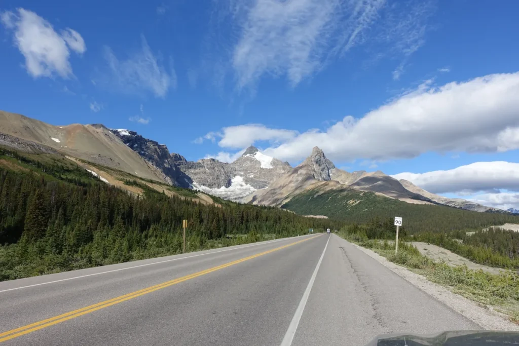
The Icefields Parkway is a mountain drive between Lake Louise and Jasper, not a string of stops clustered around one town. Group the lakes, icefield and waterfalls by their position on Highway 93 North, then leave time for the road and for the stops that matter most to you.
Bow Lake south, the icefield midway, Athabasca Falls north
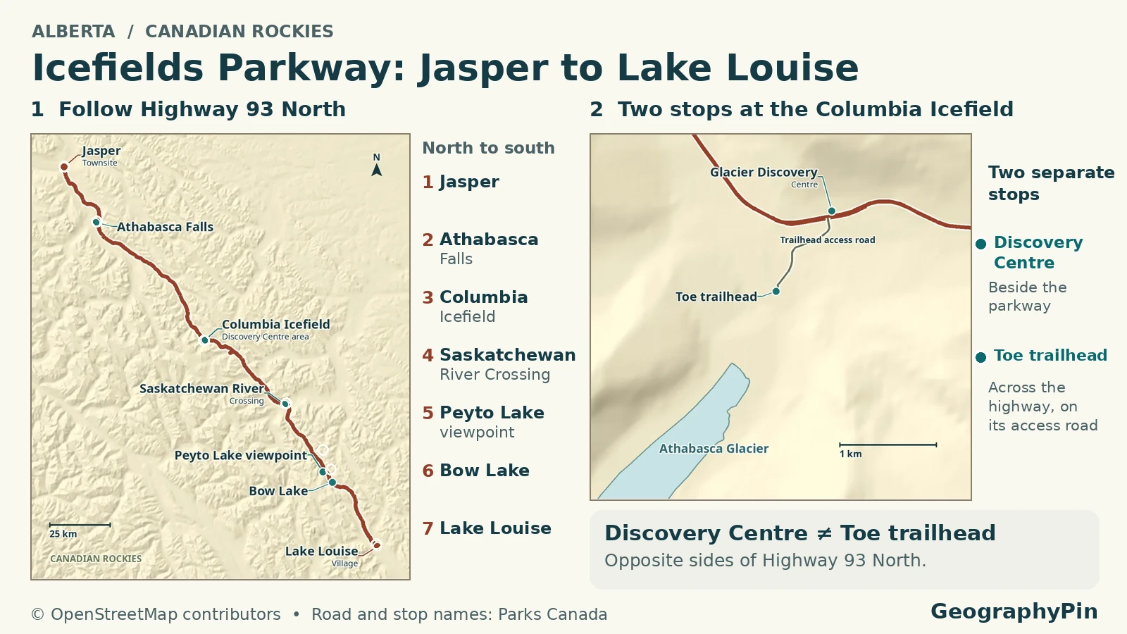
For a one-way Icefields Parkway itinerary, group Bow Lake and Peyto Lake near the Lake Louise end, make one deliberate Columbia Icefield stop, and save Athabasca Falls for the Jasper end. Reverse that order southbound. Add sightseeing to the driving time, and check Highway 93 North before setting out.
Starting and ending in Lake Louise? Group Bow Lake and a Peyto Lake stop, then retrace Highway 93. Driving through to Jasper? Continue from the Icefield area to Athabasca Falls. The road-time estimate does not cover stops, parking or walks.
How to use this article: Compare the three stop groups, identify the correct glacier or tour arrival, distinguish Jasper’s two waterfall stops, or check winter driving requirements.
Plan the drive in three parts
Highway 93 North (93N) runs through Banff and Jasper national parks. Parks Canada describes the Parkway as about 144 miles (232 kilometers) long and advises allowing 3–4 hours for the drive, before sightseeing. The separate approach to the Lake Louise lakeshore is not the southern start of the Parkway.
Which stops belong to the same part of the drive?
| Section | Natural grouping | How to use it |
|---|---|---|
| South: Lake Louise end | Bow Lake and Peyto Lake | Pair the two if access and parking allow. This is the simplest group for a short return outing from Lake Louise. |
| Middle: Columbia Icefield | Discovery Centre or Toe of the Athabasca Glacier trailhead | Choose the correct arrival point before setting a time. A booked experience changes the rest of your day. |
| North: Jasper end | Sunwapta Falls and Athabasca Falls | Both are north of the icefield. If short of daylight, choose one rather than stopping at both. |
Park and road information checked November 20, 2026. A through trip ends at the other community. Returning to the starting town adds the drive back; it does not fit the same time budget. For an out-and-back visit, use the group closest to your base and set a turnaround time.
Bow Lake and the southern stops
Parks Canada lists two distinct Bow Lake arrivals. Bow Lake Viewpoint and Day-use Area is approximately 23 miles (37 kilometers) from Lake Louise and is listed as summer only. The separate main Bow Lake parking area is reached via the turnoff toward The Lodge at Bow Lake on the north shore, at roughly 24 miles (39 kilometers) from Lake Louise.
Use the day-use area for a planned roadside break when it is open, or the main lot for the north-shore approach. The summer-only label on one does not describe the other. Parks Canada notes a short gravel approach from the main lot to the lakeshore, but snow and ice can change footing; check the local report before counting on a walk.
Continue to the Bow Summit/Peyto Lake area, roughly 27 miles (43 kilometers) from Lake Louise. Peyto is not a view from Bow Lake’s parking area. Choose the correct access and amount of walking rather than treating Bow Summit as another Bow Lake stop.
Do not let a full lot force a tight timetable. Parks Canada warns that summer lots can fill and there may be no space to wait. If one stop is full, carry on to your next planned stop rather than parking outside designated areas. Treat Bow Glacier Falls as a separate hike and check its trail bulletin rather than adding it to a quick lakeshore stop.
Choose the right Columbia Icefield stop
Discovery Centre and glacier trailhead are different arrivals
The Columbia Icefield is the larger ice mass. Athabasca Glacier flows from it, but seeing the glacier, visiting the centre and checking in for a commercial excursion are different plans. Choose the destination name that matches what you want to do.
| Destination | From Lake Louise / from Jasper | Use it for |
|---|---|---|
| Columbia Icefield Discovery and Information Centre | About 80 mi (128 km) / 65 mi (104 km) | Seasonal visitor facilities and the tour operator’s check-in and shuttles. |
| Toe of the Athabasca Glacier Trail (Trail 52) | About 81 mi (130 km) / 64 mi (103 km) | The separate foreland trailhead, subject to access and trail conditions. |
These are rounded Parks Canada route-table distances; do not subtract them to estimate a walk between lots. The Discovery Centre is listed as summer only. Parks Canada separately lists seasonal motor-vehicle access on Toe of the Glacier Road, so do not assume you can drive to that trailhead in winter even when 93N is open.
The commercial operator calls the tour hub the Glacier Discovery Centre. Its glacier and Skywalk shuttles leave from there, with different parking or check-in directions for particular products. Follow your ticket instructions. The tour shuttle is not transportation from Lake Louise or Jasper.
At the glacier trail, stay on the marked route and off the ice. The approach through the rocky foreland is not a self-guided glacier crossing. Check the current Parks Canada trail report before leaving the highway.
Athabasca Falls and the approach to Jasper
Sunwapta Falls is not Athabasca Falls
Northbound from the icefield, Sunwapta Falls comes first, about 34 miles (54 kilometers) from Jasper. Athabasca Falls follows, about 19 miles (30 kilometers) from Jasper. Bow Lake and Peyto Lake are on the opposite side of the icefield, toward Lake Louise.
At Athabasca Falls, short built paths lead to several views of the river in its gorge. Stairs and a bridge serve some viewpoints, so the published description does not guarantee step-free access to every view. Stay behind barriers and never use icy riverbanks or frozen water as a shortcut.
Use the 93N approach and check the turnoff. 93A (Wabasso Road) is a different road and has seasonal closures. A route app suggesting 93A as a through alternative is not evidence that it is open or suitable for your vehicle. Check the park’s road restrictions and 511 Alberta.
Check road conditions, fuel and your return
Winter equipment, fuel and no cellular coverage
Parks Canada requires snow tires marked with a snowflake or M+S, or tire chains, from November 1 through March 31 and at other times when the Parkway is covered with snow and ice. Check the actual tires or approved equipment before leaving on a rental, rather than relying on the size or drivetrain of the vehicle.
Fuel in Lake Louise or Jasper. Parks Canada lists the station at Saskatchewan River Crossing as summer only. Its winter guidance says not to count on fuel, restaurants, lodging or cellular service between the endpoints. Some toilets may be available, but that is not a reason to expect a staffed stop. Download the route and carry what you need before leaving town.
Use 511 Alberta to check Highway 93N before departure; check Parks Canada separately for the specific trail or access road. The road can close for weather or avalanche control, and 511 explicitly says no available report does not mean normal conditions. Choose a shorter outing, postpone or turn back when conditions do not support the drive.
Without a car, compare a point-to-point transfer with a sightseeing tour. A transfer is useful for reaching your next accommodation, but does not generally promise the stops you want. Pick a sightseeing product only after confirming where it boards, where it leaves you, and which stops it actually includes. Published seasonal examples are not proof of service on your travel date.
Frequently Asked Questions
Do I need a national parks pass if I only drive through?
Parks Canada says a valid national parks pass is required to drive the Icefields Parkway. Check its current admission information for your dates; the parks pass is not a reservation for a commercial glacier tour.
Can park avalanche control make a nearby slope safe for walking?
No. Parks Canada says its Parkway avalanche work protects road travel, not nearby mountain recreation. An open highway tells you nothing about whether an adjacent route is suitable for walking or snowshoeing.
Can I bring a pet on the commercial Icefield shuttles?
The operator does not allow ordinary pets on its glacier experiences or Skywalk. It makes an exception for qualifying service animals; check its documentation policy before travel. A rule for a public trail or viewpoint does not apply to the tour vehicle.
What Did We Learn Today?
Group the southern lakes, the icefield and the Jasper-side waterfalls separately. At the icefield, pin the entrance that matches your plan. Allow time beyond the drive, carry what you need between towns, and check road and local access conditions before committing to a stop or a full crossing.
Sources & Data Notes
Reviewed November 20, 2026: Parks Canada stop table and Highway 93N guidance, Banff National Park route and seasonal services, winter maintenance, drive estimate and avalanche guidance, Jasper road restrictions, winter driving and parks pass, 511 condition definitions, commercial shuttle and pet policy, example sightseeing transfer product. Stop distances use the named Parks Canada route-table entries, rounded and converted to miles. Highway length and distances from different reference points may differ slightly. No live road, parking or tour availability is asserted.
Photograph: Icefields Parkway 2025, Douglaspperkins / Wikimedia Commons / CC BY-SA 4.0, August 12, 2025. Resized and converted to WebP without cropping; derivative remains under CC BY-SA 4.0.

The atlas uses OpenStreetMap contributors (ODbL) and AWS Terrain Tiles. It shows mapped geography, not current access or the actual current edge of the glacier.